Полная версия
Scotland
Vertical crustal movement linked to erosion or deposition
Addition or subtraction of material to the surface of the Earth is happening all the time as sediment is deposited or solid material is eroded. The discipline of sedimentology is concerned with the wide range of different processes that are involved in the erosion, transport and deposition of material, whether the primary agent of movement is water, ice, mud or wind. An important point is that few of these sedimentary processes relate directly to the large tectonic movements of the Earth’s crust that we have discussed above. Landscape is often produced by erosion of thick sedimentary deposits that formed in sedimentary basins where material eroded from the surrounding uplands accumulated. One of the characteristic features of these thick deposits is their layered appearance – as, for example, in the Torridonian Sandstones of northwestern Scotland (see Chapter 4). Layering varies from millimetre-scale laminations produced by very small fluctuations in depositional processes, to sheets hundreds of metres thick that extend across an entire sedimentary basin. These thicker sheets are often so distinctive that they are named and mapped as separate geological units representing significant changes in the local environment at the time they were deposited.
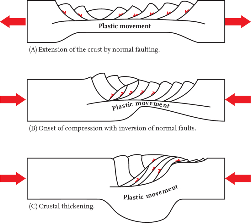
FIG 18. Example of a cross-section through the crust, showing how a divergent movement pattern (A) may be modified by later convergent movements (B and C).
Vertical crustal movements due to loading or unloading
In addition to the direct raising or lowering of the surface by erosion or deposition, there is a secondary effect due to the unloading or loading of the crust that may take some thousands of years to produce significant effects. As mentioned above, we can visualise the lithosphere as ‘floating’ on the asthenosphere like a boat floating in water. Loading or unloading the surface of the Earth by deposition or erosion will therefore lower or raise the scenery, just as a boat will sit lower or higher in the water depending on its load.
An example of such loading has been the build-up of ice sheets during the Ice Age. The weight of these build-ups depressed the Earth’s surface in the areas involved, and when the ice melted the Earth’s surface rose again. Western Scotland provides an example of an area that has been rising because of ‘rebound’ since the ice of the Ice Age disappeared on melting.
A second example of this is the lowering of the area around the Mississippi Delta, loaded by sediment eroded from the more central and northern parts of North America. The Delta region, including New Orleans, is doomed to sink continually as the Mississippi River deposits sediment around its mouth, increasing the crustal load there.
Conversely, unloading of the Earth’s surface will cause it to rise. Recent theoretical work on the River Severn suggests that unloading of the crust by erosion may have played a role in raising the Cotswold Hills to the east and an equivalent range of hills in the Welsh Borders.
Vertical movements due to thermal expansion or contraction
Changes in the temperature of the crust and lithosphere are an inevitable result of many of the processes active within the Earth, because they often involve the transfer of heat. In particular, rising plumes of hot material in the Earth’s mantle, often independent of the plate boundaries, are now widely recognised as an explanation for various areas of intense volcanic activity (for example beneath Iceland today). These plumes are often referred to as ‘hot spots’ (Fig. 15). Heating and cooling leads to expansion or contraction of the lithosphere and can cause the surface to rise or sink, at least locally.
An example of this is the way that Britain was tilted downwards to the east about 60 million years ago. At about this time, eastern North America moved away from western Europe as the North American and Eurasian plates diverged. The divergence resulted in large volumes of hot material from deep within the Earth being brought to the surface and added to the crust of western Britain. It is believed that the heating and expansion of the crustal rocks in the west has elevated them above the rocks to the east, giving an eastward tilt to the rock layers and exposing the oldest rocks in the west and the youngest ones in the east.
THE CHALLENGE OF MEASURING CRUSTAL MOVEMENTS
Having just reviewed some of the processes that may cause movements of the Earth’s surface, it is useful to consider the practical difficulties of how such movements are measured.
For present-day applications, it seems natural to regard sea level as a datum against which vertical landscape movements can be measured, as long as we remember to allow for tidal and storm variations. However, much work has demonstrated that global sea level has changed rapidly and frequently through time, due to climate fluctuations affecting the size of the polar icecaps and changing the total amount of liquid water present in the oceans and seas (see Chapter 5). It has also been shown that plate tectonic movements can have an important effect on global sea level by changing the size and shape of ocean basins.
Attempts have been made to develop charts showing how sea level, generalised for the whole world, has varied through time. However, it has proved very difficult to distinguish a worldwide signal from local variations, and the dating of the changes is often too uncertain to allow confident correlation between areas.
In sedimentary basins, estimates of vertical movements have been made using the thicknesses of sediment layers accumulating over different time intervals in different depths of water. In areas of mountain building, amounts of vertical uplift have been estimated using certain indicator minerals that show the rates of cooling that rocks have experienced as they were brought up to the surface. However, both these approaches are only really possible in areas that have been subjected to movements of the Earth’s crust that are large and continuous enough to dominate completely other possible sources of error.
Local movements are also difficult to estimate, although fold and/or fault patterns may allow a simple measure in some cases. Over short present-day periods of time it has proved to be possible to detect vertical movement patterns using satellite imagery. Movement of sediment across the Earth’s surface by rivers or sea currents can be estimated if mineral grains in the sediment can be tracked back to the areas from which they have come. In the detailed consideration of landscapes in this book, we have to rely on using the widest possible range of types of evidence, carefully distinguishing the times and scales involved. Even then, we are often left with probable movement suggestions rather than certainties.
CHAPTER 4
Episodes in the Bedrock History of Scotland
CHAPTERS 2 AND 3 HAVE INTRODUCED the idea that natural landscapes are the results of combinations of surface modification (Chapter 2) and internal movements (Chapter 3). The responses of the Earth’s surface to these combinations have depended on the bedrock present locally on the surface at each stage. It is now time, therefore, to turn specifically to Scotland, to summarise the distribution and history of its bedrock.
The mapping of the bedrock of Scotland has been a heroic task that started over 200 years ago. Most of the systematic work has been carried out by the British Geological Survey, and is now available on different scales, forming a monument to the efforts of many remarkable people and the Survey itself (Fig. 19). For the generalising approach of this book much of this work has had to be simplified.
Scotland’s geological history is unusually long and varied for a country of its size. One reason for this is that present-day Scotland is the result of the convergence or movement together of at least five different areas of crust, often referred to as terranes (Fig. 20). These terranes are fragments of continental crust that have been carried together by plate tectonic movements that resulted eventually in the construction of crustal Scotland, as we find it now.
Although most of the surface modifications and internal movements have overlapped in time and space, it helps to pick out discrete episodes in summarising aspects of Scotland’s history. The first nine of these episodes are represented in the bedrock record and are outlined in the rest of this chapter. Episodes 10–12 are mainly represented in the record of recent surface modifications, and they are described in Chapter 5. All 12 episodes have been placed in chronological order in Figure 21 (where Episode 1 is the oldest and 12 the most recent) using the International Stratigraphy Chart 2009, which provides an accepted standard for the names used in dividing and describing geological time (see www.stratigraphy.org).
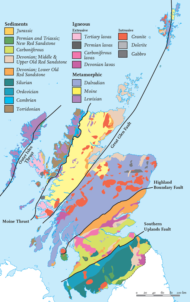
FIG 19. Simplified geological map of Scotland. (Redrawn from British Geological Survey 1 : 625,000 map)
We provide a ‘Timeline’ as part of the description of the geology of each of our Areas. These timelines are designed to summarise the time sequence of events that is represented in or near each Area, using the standard International Stratigraphic divisions. Standard colours are used for the divisions and ages. If part of the stratigraphic record is absent, the division is not coloured.
The bedrock episodes can be grouped as follows:
(1) Pre-Caledonian Greenland-margin episodes (Episodes 1–3)
(2) Caledonian mountain-building episodes (Episodes 4–6)
(3) Post-Caledonian episodes (Episodes 7–9)
The distribution of these groups of rocks is shown in Figure 22, and the episodes involved in their formation are described below.
PRE-CALEDONIAN GREENLAND-MARGIN EPISODES
Episode 1: formation of the Lewisian Complex
Rocks of the Lewisian Complex are very largely restricted to the Hebridean terrane, where they make up almost all of the bedrock of the Outer Hebrides, and much of the bedrock of the mainland. They also occur occasionally in the neighbouring part of the Northern Highland terrane, where they became involved in the much younger Caledonian movement history. The Lewisian Complex takes its name from the largest and northernmost of the islands of the Outer Hebrides.
The Lewisian Complex consists of metamorphic rocks (typically coarsely crystalline gneisses) that formed by alteration of earlier rocks when high temperatures and/or pressures peaked during movements at deep levels within the Earth’s crust. The great interest of these metamorphic rocks is that they can provide information about the conditions deep within the crust when these movements were taking place. Unlike igneous rocks that formed by crystallisation from completely melted rock material, metamorphic rocks have involved changes in rocks that were at least partly solid, so they preserve information about features present before, as well as conditions during, the metamorphism. In most cases, the minerals now present are stable at present-day surface temperatures and pressures, are large in crystal size, and interlock with neighbouring crystals, so the rocks are resistant to surface weathering compared with many other rock types.
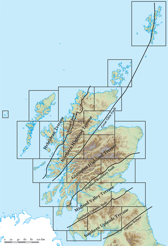
FIG 20. The five terranes of Scotland. (After Trewin 2002)
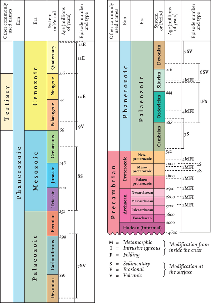
FIG 21. Episodes in Scotland’s geological history. The age scale is not linear and has been deliberately chosen so that younger episodes are given greater space than older ones, because they are usually known in greater detail. The chart indicates the ages covered by the 12 episodes, and the dominant processes represented by them. (Redrawn from International Stratigraphy Chart 2009, www.stratigraphy.org)
One of the most important research tools applied to the Lewisian rocks has been the dating of the various mineral components, using the fact that some of them contain radioactive materials that have been steadily changing since they were first trapped when the minerals formed. The amount of change gives a measure of the time over which it has been taking place. New analytical methods have led to increasingly accurate and reliable figures. As this work has continued, it has become clear that the Lewisian is truly a ‘complex’, made up of many distinct volumes of crust, each preserving certain episodes of movement and rock alteration. Many of the folds or fractures mapped in the Lewisian have a northwest/southeast trend, almost at right angles to the Moine Thrust Zone and the associated folds and fractures that form the margin of the Hebridean terrane. However, mapping of these structures has shown that the movement and alteration of the Lewisian occurred in a number of phases with different compression and shearing directions. The evidence is too fragmentary to allow identification of the boundaries of tectonic plates similar to those that can be identified in younger bedrock areas. This is hardly surprising, because these are some of the earliest movement events recognised anywhere on the surface of the whole Earth, representing glimpses of early crustal activity that has escaped reworking or obliteration in more recent episodes.
Important phases of activity and mineral alteration have been recognised in the Lewisian Complex, some in the Archaean (3.2 and 2.8 billion years ago), generally named Scourian and Inverian. Other rocks were formed and/or altered in the Proterozoic (2.4, 1.7 and 1.1 billion years ago) and are named Laxfordian. The Archaean phases are older than any other for which there is evidence in Britain. Most of the rocks altered in these phases were originally igneous but some were sedimentary, and all had actually been formed as rocks even earlier. It is clear from the minerals present that some phases involved crust being moved downwards to considerable depths – several tens of kilometres below the surface – although before the next episode (described below) the rocks had been moved back upwards and were exposed at the surface.
Surface modification of the Lewisian during the Tertiary and the Ice Age has carved it into typical ‘knock-and-lochan’ topography, in which the land surface consists of hillocks of exposed rock tens to hundreds of metres across (called knocks, from the Gaelic cnoc, a small, rocky hill), separated by water and bog-filled hollows (lochans) which often pick out folds and linear fractures in the bedrock (Fig. 23). This wild knock-and-lochan landscape was once thought to represent the first formed surface of the Earth, but it is now realised that the surface shapes of the landscape are very much younger, and that the metamorphic alterations and movements, although very old, were preceded by even earlier episodes.
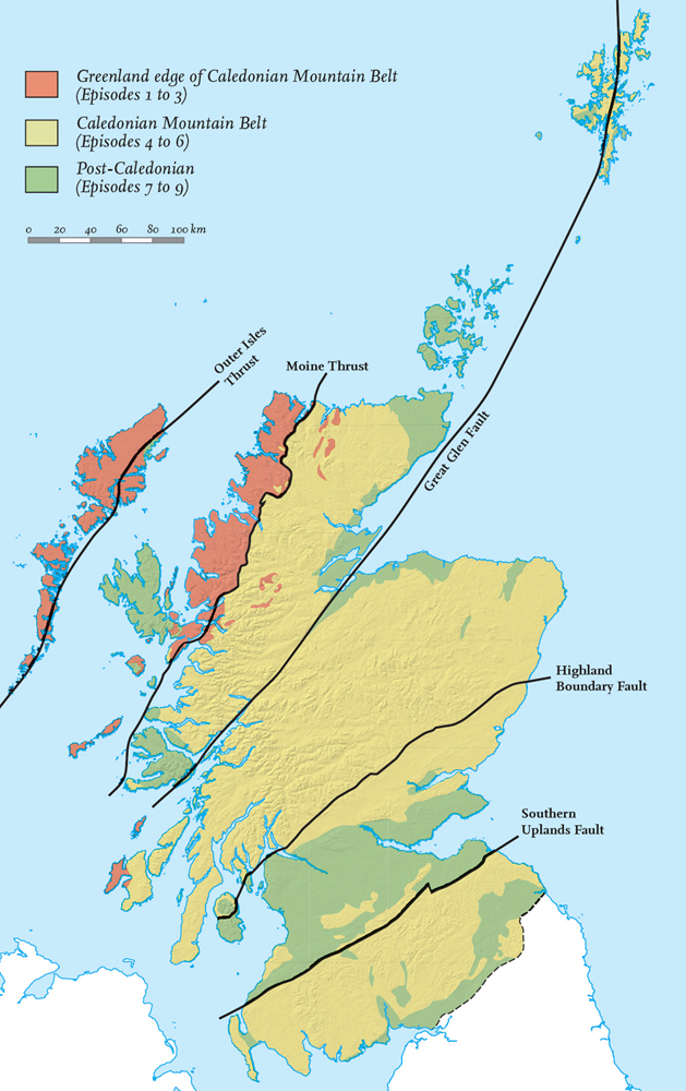
FIG 22. The distribution of the Pre-, Syn- and Post-Caledonian rocks in Scotland.
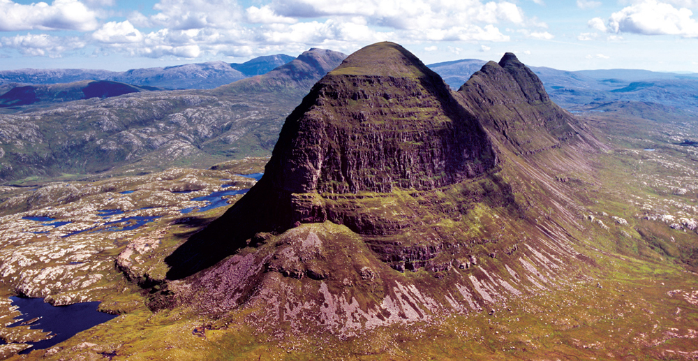
FIG 23. Aerial oblique view of Suilven (731 m), carved from Neoproterozoic Torridonian Sandstones resting unconformably on the knock-and-lochan topography of the Lewisian Complex. (© Adrian Warren/lastrefuge.co.uk)
Episode 2: formation of the Torridonian Sandstones
Mountains and slopes made of uniform but well-layered successions of Torridonian Sandstones, often tens to hundreds of metres thick, provide some highly characteristic elements of the Hebridean terrane (Fig. 23). The layers are generally rather flat-lying, except in the folded and faulted bedrock of the Moine Thrust Zone where the Torridonian has been deformed along the eastern terrane boundary. Careful examination of the layering shows that it generally reflects episodes in the life of Torridonian rivers, which occasionally flooded and deposited sandy or gravelly river bars, often with muddy tops that have weathered to pick out the layers . Although much of the Torridonian was deposited by rivers, some of it accumulated in lakes or in the sea.
At least two different episodes of deposition are represented in the Torridonian Sandstones, and these have been dated, using radiometric methods, as Mesoproterozoic and Neoproterozoic (1.2 and 1.0 – 0.95 billion years ago respectively: Fig. 21). These two episodes left thick successions of sediment in the crustal record: up to 2 km in the Mesoproterozoic and up to 5 km in the Neoproterozoic. Thicknesses as great as these imply the downward movement of certain areas (basins) of the Earth’s surface close to areas where erosion due to upward movement was producing large quantities of sediment. In other words, although the Torridonian Sandstones are the result of modification by surface processes, these processes must have been linked to important vertical movements of the crust, due to forces acting within the Earth.
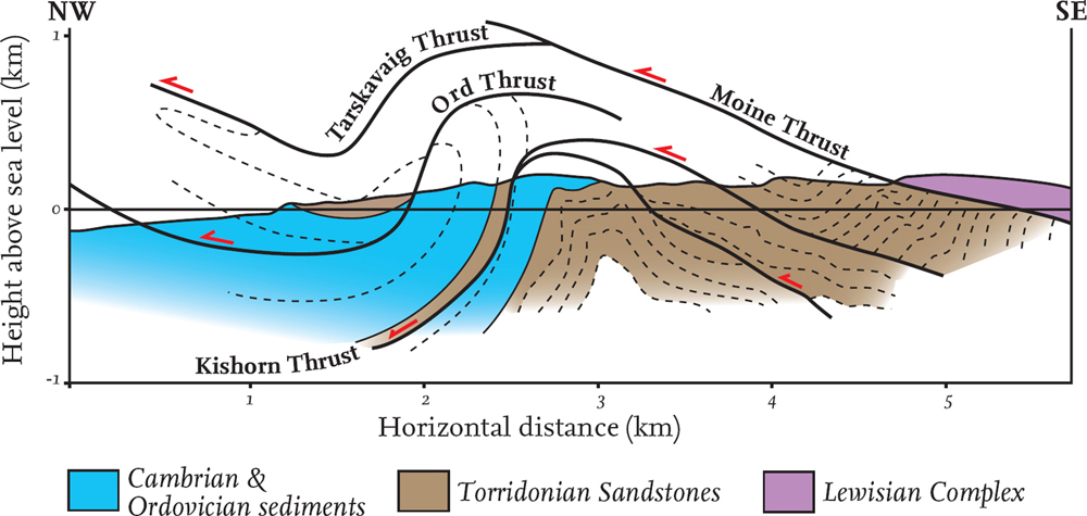
FIG 24. Cross-section through the Ord window of Southern Skye, showing the folded and fractured structure of the bedrock below the Moine Thrust.
The contact between the flat-lying layering of the Torridonian and the underlying Lewisian Complex is an unconformity that formed when the Torridonian sediments were deposited onto topography of valleys and hills (often hundreds of metres in relief) that had been carved in the Lewisian Complex. This unconformity, although preserving local Proterozoic hills and valleys, is relatively flat-lying overall, showing that widespread vertical movements – rather than significant folding or tilting – must have been involved.
The western and eastern margins of the present-day Atlantic Ocean were close to one another within a ‘super’-continent when the Torridonian sediments were accumulating. It seems likely that much of the sediment was derived from upland areas whose crust is now in Greenland or eastern Canada.
Episode 3: Cambrian and Ordovician sedimentation
A rather uniform succession of sediments of Cambrian and Ordovician age occurs more or less continuously along a strip from Skye, in the south, to the north coast of the Scottish mainland (Figs 19, 20, 22: our ‘Greenland edge’). This succession was deposited unconformably on the eroded rocks of the Lewisian Complex and the Torridonian Sandstones. These Cambrian and Ordovician sediments only occur in the Hebridean terrane, and their usually gentle tilt is evidence of the lack of later movements, although they have been folded and fractured in the Moine Thrust Zone along the terrane’s edge (Fig. 24).
Where most fully developed, this sedimentary succession is about 1 km in thickness and consists of a lower unit of quartzites (up to 100 m thick) that forms a greyish-white cap on some mountains and weathers to produce distinctive angular scree and boulder fields. Above this is a thin unit of mudstones, fractured and folded by subsequent movements on the Moine Thrust, overlain by a thick succession of limestones which, according to the fossil evidence contained within them, span the time interval from early Cambrian to early Ordovician (Fig. 21). In the present-day landscape, these limestones often produce swallow holes and caves formed by solution of the limestone’s fracture joints, as well as unusually lush grass wherever there is significant soil development.
The whole of this succession appears to have formed on the edge of a sea, and the occurrence of similar sediments on both sides of the present-day North Atlantic, a much more recent feature of the Earth’s surface, suggests a widespread uniformity in the coastal environments at this time. It is believed that these deposits formed due to surface modification involving global sea-level change, with no clear evidence of local movements due to processes deeper within the Earth.
CALEDONIAN MOUNTAIN-BUILDING EPISODES
The Latin adjective Caledonian is widely used to indicate Scottish-ness, and is used in geology for the important phase of mountain building that dominated earth movements and surface modification in Scotland between Ordovician and Devonian times. Evidence of similar movements and modifications during the same time periods is found along the east coast of the USA, Canada and Greenland, and through Ireland, Norway, Sweden and Spitsbergen. The terranes now recognised in Scotland have been mentioned above and shown in Figure 20. Distinct areas of continental crust, some thousands of kilometres across, others much smaller, rode on plates (Chapter 3) that moved independently and came together at different stages over Ordovician, Silurian and Devonian times to create the final assemblage of crustal fragments now present in Scotland. The main crustal fragments and their plates and intervening oceans are tracked in summary in Figure 25.
Episode 4: making the core of the Caledonian mountains
The core of the Caledonian mountain belt is represented by the metamorphic bedrock that forms most of the Northern Highland and Grampian Highland terranes (Fig. 20). The metamorphism of the originally largely sedimentary rocks occurred under the high pressures and temperatures that reflect their deep burial when compressive movements caused thickening of the crust and mountain uplift at the surface.
For many years a distinction has been drawn between the Moine and Dalradian supergroups in the mapping of the metamorphic core of the Caledonian mountain belt (Figs 19 and 20). The Moine Supergroup was named after a stretch of moorland on the north coast. It forms most of the Northern Highland terrane and may be present also in part of the Grampian Highland Terrane (Fig. 19). In contrast, the Dalradian Supergroup contains a greater variety of metamorphic rock types that have made it possible to trace distinctive subdivisions across most of the rest of the Grampian Highland terrane and even into Shetland. The name Dalradian has many historic roots and, in a geological sense it simply indicates association with the Scottish Highlands and parts of Ireland. There is general agreement that the original (pre-metamorphism) sediments of the Moine are older than those of the Dalradian, but the mapping of any boundary between them is still very arbitrary, and is not important in our review of landscapes across Scotland.
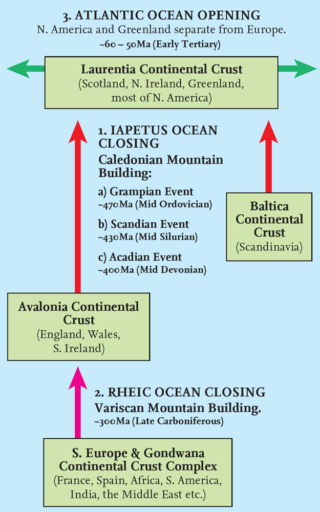
FIG 25. Diagram showing major plate-scale ocean closings and openings, with compressive events on the plate margins that generated events during the Caledonian and later Variscan mountain building. Ma (mega-annum) = million years ago.
The dominant bedrock of both these supergroups is metamorphic. In other words, the bedrock has been altered but not melted, during the growth of new minerals under the high temperatures and/or pressures generated by compressive movements and thickening of the crust. The original rocks of the Moine and Dalradian were mostly formed as sediments, mainly muds and sands but also occasionally lime-rich sediments. These sediments have now been transformed into schists (also called pelites; originally mudstones) and psammites (originally sandstones).
Knowledge of the age of the original rocks and the age of their alteration depends on sophisticated analysis of the decay of radioactive mineral components. The Moine Supergroup appears to have been deposited in the Neoproterozoic (about 1000 – 900 million years ago), so it was being formed at the same time as part of the Torridonian succession, although horizontal movements have brought them closer since they formed. Today, the Moine contains evidence of at least three different episodes of mineral alteration, the first around 850 million years ago (Knoydartian), the second 470 million years ago (Grampian; mid-Ordovician) and the last roughly 430 million years ago (Scandian; mid-Silurian), each resulting from phases of movement in the Earth’s crust where the rocks were moved, folded and fractured (Fig. 21). The Grampian and Scandian episodes are usefully distinguished as important phases in building the core of the Caledonian mountain belt. A further phase, the Acadian (mid-Devonian, 400 million years ago), is more clearly seen in other areas, showing that the movement pattern along the mountain belt involved many distinct continental fragments with different movement histories (Fig. 25). Much later, in the Mesozoic and Cenozoic, this belt was split by the plate divergence that formed the Atlantic Ocean, explaining why today there are other fragments of the Caledonian belt in Canada, Greenland and Scandinavia.