

Полная версия
Britain’s Structure and Scenery
morphe form, hence the process is called contact metamorphism).
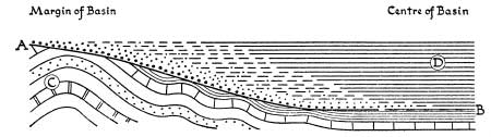
FIG. 7.—Diagrammatic Section of an Unconformity A—B is the plane of the unconformity. After the deposition of the group of beds marked C they were gently folded by earth-building movements and were subjected to denudation. Gentle subsidence followed so that the group of beds marked D were deposited gradually over a larger and larger area—they rest unconformably on the older series and at the same time overstep them. In the centre of the basin fine-grained shales were deposited and the diagram suggests that sedimentation was almost continuous. Towards the margins of the basin the fine-grained deposits pass laterally into sands and other coarser sediments and to shore deposits.
This section represents diagrammatically the relationship between the Silurian and the underlying Ordovician in the Welsh Borderlands. See also Plate IV B.
Thus clay and shale are baked into hard slatey rocks, limestone is changed into marble. Some of the molten rock is very fluid when it is first poured out and spreads evenly over a wide surface as did the basalts of Northern Ireland; sometimes it formed hexagonal columns on cooling as at Giant’s Causeway and the Island of Staffa (Plate XVA). In other cases the molten rock was very sticky and consolidated almost on the spot—the famous conical “spire” of Mont Pele of Martinique in the West Indies is the best modern example of this (it was formed during the disastrous eruption in 1902) but there are many examples from earlier periods in the British Isles, such as Ailsa Craig in the Firth of Clyde. Even more important, though it cannot be observed at the surface, is the underground movement of great masses of molten “magma.” At the height of great earth-building movements the magma is squeezed into the core of mountain ranges so that millions of years afterwards, when the mountains have been denuded down to their roots, this core is exposed. A typical rock so formed is granite. The metamorphism caused by a huge granite mass taking eons to cool can perhaps be imagined rather than described and the “metamorphic aureole” is often very extensive; it is economically important because of the valuable metallic minerals which are associated with the gases and heated liquids given off by the magma. These latter often find their way into cracks or veins and there the minerals are deposited—hence the association of ores of tin and copper with the metamorphic aureoles of the granites of Devon and Cornwall. These Devon and Cornish granite masses are the roots or cores of giant mountains formed by the Armorican earth movements but long since worn down almost to a level surface. It is clear that there is a definite cycle of igneous activity associated with a cycle of earth movements—volcanic activity heralding the oncoming storm; intrusion and movement of huge underground masses at the height of the storm; and finally renewed volcanic activity when the storm is dying away. The few volcanoes on the surface to-day which are active may be regarded as the last remnants of the once wide-spread activity at the end of the Alpine earth movements. Many of those are at the end of their lives—dormant or even extinct or merely giving off vapours (“sol-fataric stage”). Hot springs and geysers are indications of a nearly dead volcanic area.
One of the still unsolved puzzles of earth history is whether or not there have been true climatic cycles in the past. There is no doubt that at several periods there have been ice ages, though perhaps nothing as severe as that which overwhelmed the northern hemisphere so recently in geological time that man was already well established and hence known simply as “the Ice Age.” We know definitely that some of the red rocks found in the British Isles—such as the Permian or New Red Sandstone—were laid down under desert conditions and there must have been other times when what is now our country must have been wet and hot. Many of the phenomena, however, may be explained by a different distribution of land and water in the past or at most by a shifting of the earth’s axis.
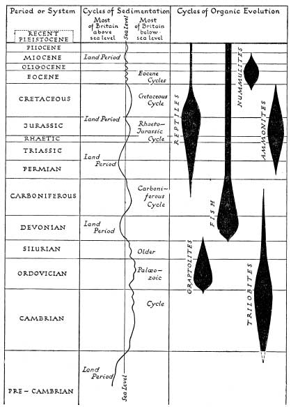
FIG. 8.—Major episodes in Earth History
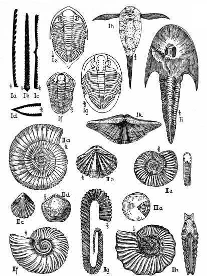
FIG. 9.—Some characteristic Fossils.
Those numbered I are Palaeozoic; those numbered II are Mesozoic and III Cenozoic.
Graptolites:—Ia Monograptus (Silurian); Ib Diplograplus (Ordovician); Ic Didymo-graptus extensus (Ordovician); Id D. murchisoni (Ordovician). Trilobites:—Ie Phacops caudatus (Silurian); If Calymene blumenbachi (Silurian); Ig Ogygia buchi (Ordovician). Primitive fish:—Ih Pterichthys milleri and Ii Cephalaspis lyelli (Old Red Sandstone). Brachiopods:—Ik Spirifer verneuilli (Devonian); IIb Spiriferina walcotti,; 11c Rhynchonella rimosa and 11d Waldheimia numismalis (all Lias). Ammonites:—11a Dactylioceras commune (Lias); 11e Pcrisphinctes biplex (Jurassic, Kimerid-gian); 11f Hoplites splendens (Cretaceous: Gault); 11g Hamites attenuatus (Crctaceous: Gault): 11h Hoplites auritus (Cretaceous: Greensand). Nummulites: 111a Nummulites laevigatus (Eocene).
The existence of a plastic or semi-molten layer under the solid part of the earth’s crust has already been argued and there is nothing inherently impossible in the idea that the continents consist of relatively light rocks and form masses as it were floating on a plastic layer. If this is so, it is but one step towards the idea that the continental masses may drift away from or towards one another—hence the Theory of Continental Drift associated with the name of the German geologist Wegener. But the attempt to secure observational confirmation of drift, however slight, has been disappointing.
The similarity in the rocks which make up such widely separated lands as Africa, Peninsular India and western Australia is so striking, however, that this absence of direct observational proof of drift is inconclusive. It may be that drift only takes place at certain periods when the underlying rocks are in a particular condition of plasticity.
Amidst all the changing scenes which geological time has witnessed—for we may say that geology is really geographical evolution—there has gone on the evolution of living organisms. Just as in times of war things happen and life is speeded up so there is some evidence to show that the rapidly changing environmental conditions which must have characterised the great periods of earth movement induced a rapidity of organic evolution. Whether that be so or not the fact remains that before the Caledonian movements the world was populated almost exclusively by lowly plants which have left few traces and by invertebrate animals. After the movements was the age of fishes—the many weird forms of the Old Red Sandstone—and a rapid evolution of fern-like plants. Before the Armorican movements there were some amphibians but it is after the movements that we have the great age of reptiles and the seas became populated by the well-known coiled ammonites and innumerable brachiopods. The curious graptolites which scarcely survived the Caledonian movements had completely gone. The doom of the heavily armoured and small-brained Jurassic and early Cretaceous reptiles was sealed well before the earliest inklings of the Alpine movements. The victory of the mammals, with man himself to follow later, was assured long before the time the Alpine storm really broke.
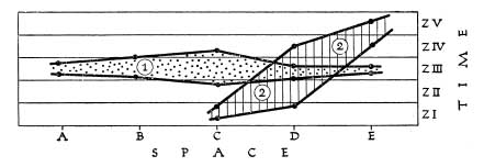
FIG. 10.—Diagram illustrating the distribution in time and space of a typical fossil. ZI, ZII, ZIII, ZIV, ZV are zones
The species 1 is found at all five localities A, B, C, D and E and is restricted in its vertical distribution to Zone III. Only in one locality, C, is it found slightly below and slightly above the limits of the zone. It is therefore a good “zonal index.” Species 2, on the other hand, is only found in three of the five localities; it has a wide range in time and is found at a much lower horizon in locality C than in locality E. It is therefore of no use as a zonal index but such a distribution is characteristic of a “facies” fossil—a species seeking some special habitat conditions such as shallow water near a shoreline.
We are now in a position to apply the general principles already enunciated and to see how far they explain the building up of the present-day structure of the British Isles and to see what evidence the rocks of this country contain of the evolution of the great world groups of animals and plants and, in the later stages, of our own particular native fauna and flora.
CHAPTER 4
THE GEOLOGICAL MAP
DURING the war an important series of maps, designed to supply information basic to any work of national planning, was initiated by the Research Division of the Ministry of Town and Country Planning and published by the Ordnance Survey. The main series is on the scale of 1: 625,000 or approximately 10 miles to the inch and the series to be issued on that scale, covering the island of Britain in two large sheets, includes many of the maps which were proposed in the scheme for a National Atlas drawn up by the National Atlas Committee of the British Association for the Advancement of Science. Amongst the maps actually prepared and available, those of the Relief of the Land, Land Utilisation, Types of Vegetation, Types of Farming and Land Classification are very relative to the study of the natural history of this country, but fundamental to any study are the geological maps. Following the practice of the Geological Survey in some of their detailed maps, there are to be two maps—one to show the history of this country, while fundamental to any study are the geological maps. Following the practice of the Geological Survey in some of their detailed maps, there are to be two maps—one to show the “solid” geology as it would appear if superficial deposits such as boulder clay, glacial sands and gravels and clay-with-flints were removed and the other to show the “drift” geology with all those surface deposits indicated.1 It has already been pointed out that many geologists are interested primarily in the older rocks and in the structure of the earth’s crust and the superficial deposits are to them simply a nuisance; from the economic point of view in the investigation of mineral resources the same is true and so the drift deposits and their mapping have been relatively neglected—notwithstanding their supreme importance in agriculture.
The Geological Survey came into existence in 1835 as an offshoot of the Ordnance Survey and its immediate task was the mapping of the geology of the country on the scale of one inch to one mile. This work was vigorously prosecuted, especially under the energetic guidance of Sir Roderick Impey Murchison who became Director-General in 1855, and the results were published in the form of hand-coloured one-inch maps, the base maps used being the original one-inch sheets of the Ordnance Survey. These original one-inch maps were “solid” maps though indications of the presence of drift is conveyed by words printed across the map in appropriate places. Its preliminary work finished, the Geological Survey then set to work to carry out a detailed revision or second survey. The field work was done on the six-inch or even, in cases, a larger scale. Attention was concentrated on the coalfields and on areas around populous centres, together with selected tracts in different parts of the country. For purposes of publication the “small-sheet series” of one-inch Ordnance Survey maps was chosen and these have been kept up to date for use as Geological Survey base maps long after they have been superseded by other editions for ordinary uses. They cover an area of 18 miles from east to west and 12 miles from north to south, and have the advantage of showing contours in black as part of the base map. Some of the small sheets series are hand coloured but the technical advances in colour printing has meant that all the later maps have been printed in colours. Each sheet is accompanied normally by a detailed explanatory memoir. In those areas where drift deposits are widespread or important it is usual to publish two editions of the map, the Solid and the Drift Editions, which are in fact two distinct maps. After more than half a century of work only about a third of the country has been re-surveyed and the maps published, so that for the rest reliance still has to be placed on the original survey and hand-coloured maps of a century ago. There is thus an obvious difficulty in issuing generalised maps of the whole country in that the detail available is so varied from one part to another, and it explains why, in a country where superficial deposits are of such tremendous importance in the study of soils, vegetation and agriculture, there is no generalised map to show their distribution. Pending the publication of the maps on the 10-mile scale just mentioned there is a useful map of the solid geology of the British Isles on the scale of 25 miles to one inch, published by the Ordnance Survey as one sheet at the modest price of two shillings.
This map is of the greatest value in giving a general picture of the distribution in Britain of the rocks of each of the systems. In the third edition, which is dated 1939, very considerable revisions and additions were made as a result of incorporating recent work.
Speaking very generally,. in geological terms the oldest part of Britain is the north-west and on the whole the rocks become steadily younger in geological age as one goes towards the south and east so that the major stretches of the Tertiary rocks are to be found in the London and Hampshire Basins.
The great mass of the Highlands of Scotland is made up of a complex of ancient metamorphic rocks with numerous large intrusions of granite. As described more fully in Chapter 23, one must picture the whole as the worn-down stumps of the great Caledonian fold mountains and there is little to-day in the relatively tame, rolling relief of much of the Scottish moorland to suggest the wild contortions exhibited by the underlying rocks—structures the interpretation of which has long baffled and continues to baffle the most expert of geologists. The oldest rocks of all are probably the Lewisian gneisses in the Outer Hebrides but the relative ages of the different pre-Cambrian or Archaean rocks is still uncertain. Along the coastlands of the North-West Highlands is a considerable stretch of Torridonian Sandstones—still pre-Cambrian but unmetamorphosed sediments, obviously much younger than the main bulk of the Highland rocks (see Plate IB). There is a narrow belt of Cambrian also in the north-west of the Highlands but the main masses of Old Red Sandstone—reminders of the great lake basins created by the Caledonian upheaval—lie on the east. Tiny patches of Jurassic rocks both in the west and along the east coast in the far north are reminders that Jurassic seas must have stretched far north but have left only small traces, and there is little evidence of the detailed geological history of Scotland over vast periods of time. Though the Alpine earth movements failed to fold the rigid old mass of the Highlands there is abundant evidence of the way in which great cracks were formed through which poured masses of molten lava. These make the great red splashes on the map in Skye and Mull and many of the smaller Hebridean islands.
A glance at the distribution of the deep purple colour used to indicate the Cambrian and the mauves used for the Ordovician and Silurian serves to demonstrate that it is the Older Palaeozoic rocks which make up the Caledonian mountain ranges of the Southern Uplands of Scotland, the English Lake District and the Isle of Man, as well as the whole of north and central Wales. That the Old Red Sandstone occupied basins is not only clear from the Highlands of Scotland: there are broad belts in the great tectonic depression of the Central Lowlands of Scotland between the Highlands and the Southern Uplands. In the south the main stretch of the Old Red Sandstone is in the Welsh Borderland whilst marine Devonian rocks of the same age cover Exmoor and much of South Devon and Cornwall.
Three colours are used for the rocks of the Carboniferous system—blue for the Carboniferous Limestone and the Scottish rocks (with sandstones, shales and coals) of the same age; sage green for the Millstone Grit and barren Culm Measures of Devon and Cornwall, and slate-grey for the Coal Measures. In passing it must be noted that the outcrops of Coal Measures shown on the geological map are not co-extensive with the coalfields because much of the most valuable parts of the coalfields are hidden beneath younger rocks. The Carboniferous rocks, with many areas of lava and other reminders of volcanic activity, fill in the remainder of the central lowland of Scotland whilst in England one is struck at once by the great north-south stretch of Carboniferous rocks which makes up the Pennines—the so-called backbone of England. This north-south alignment is a new one: it is a reminder that the rocks were deposited long after the Caledonian folding and that after their deposition were subject to the Armorican movements. These created north-south folds such as the Pennines and Malverns, folded as it were against the older blocks to the north and west, as well as the more common east-west folds so well seen in the alignments of the beds in South Wales and in the South-western Peninsula. Where the north-south and the east-west folds crossed, the creation of basins and dome-shaped uplifts is obvious and can be clearly seen from the map. Thus the South Wales Coalfield and the Forest of Dean are examples of basins and the Mendips are an example of the uplifts.
The way in which the bright blue streak of the Magnesian Limestone (Permian) cuts across different beds of the Carboniferous shows that the latter had already been folded and denuded before the deposition of the Permian.
The remainder of the map relates to Lowland Britain. The Midlands of England show clearly the stretch of the red Triassic deposits and the islands of older rocks which appear from beneath this cover.

FIG. 11.—A Simplified Geological Map of the British Isles
Then follow the successive belts of the Scarplands (see Chapter 18), sweeping across England from north-east to south-west—brown for the Liassic clays, yellow for the Oolitic sequence, dark green for the lower Cretaceous rocks, and light blue-green for the Chalk follow one another in sequence of ever decreasing age as one goes towards the south-east. It is in the south-east that the orderly sequence is interrupted and this is a reminder that the south and south-east of Britain lay on the fringes of the great Alpine storm and that some of the rocks there were folded by the Alpine movements. The uplift of the Weald, roughly east and west in its main axis, separates the two main Tertiary basins of London and Hampshire ; the sharpest folds of Alpine date are those in the extreme south—across the Isle of Wight and the Isle of Purbeck. The location of the main stretch of Pliocene rocks in the coastal parts of Norfolk and Suffolk is suggestive, and rightly so, that by that period the geography of Britain had acquired something of its present form—only certain parts, on the whole near the present coasts, came under Pliocene seas.
There the geological story shown by the general map we have been discussing ceases. It tells us nothing of the stupendous events of the Great Ice Age. For that we must turn to the detailed drift maps and from them try to piece together what is one of the most fascinating and important, and yet, despite its recent occurrence in terms of geological time, one of the most difficult episodes to reconstruct in the geological story of the building of Britain. Before we deal with this, however, it is essential to consider how many of the major surface features of Britain have evolved.
CHAPTER 5
LAND FORMS AND SCENERY THE WORK OF RIVERS
ALTHOUGH it is clear enough that the form of the surface—the relief of the land—is in the main determined by the underlying geological structure, the relationship between land forms and structures is by no means a simple one. It is only within the past few decades that the specialist study of land forms, the science of geomorphology, by developing its own technique, has demonstrated that it is possible to reconstruct a long and often complex history by detailed investigation of the form of the ground and that the details of land relief may bear surprisingly little relationship to the structural geology. For the most part geologists have paid little attention to this natural development of their studies. Apart from a few outstanding works by geologists such as J. E. Marr’s Scientific Study of Scenery first published in 1920 and more general works such as Lord Avebury’s Scenery of England and Wales, the foundation of detailed work was laid by such physical geographers as the American W. M. Davis, whose famous studies of the evolution of rivers was nevertheless carried out in our own Wealden country, and the Frenchman Emmanuel de Martonne whose Traite de Géographie Physique contains many British examples. Much recent work has emanated from America and other detailed work from Germany. In this country some of the younger geographers, headed by J. A. Steers and W. V. Lewis, have concerned themselves especially with coastal phenomena, others such as Professor D. L. Linton and Professor A. A. Miller with river evolution whilst a leader amongst those devoted to general geomorphological studies is Professor S. W. Wooldridge, whose Physical Basis of Geography: an Outline of Geomorphology, was first published in 1937.
Briefly, it may be said that land-forms depend first on the nature of the rocks and their disposition (that is, in other words, on lithology and structure), secondly on the climatic conditions, with resulting soil mantle and vegetation cover, under which the sculpturing of the land surface has been and is taking place, and thirdly on the phase or stage within the erosion cycle.
However erroneous, it is common to find references to “hard” rocks and “soft” rocks which are regarded as respectively resistant to and less resistant to weathering. Since most of the older rocks are “hard” in this sense the common distinction is drawn between the old hard rocks and the young soft rocks characteristic respectively of Highland and Lowland Britain. Although in any given area it is broadly true that the positive features of the relief, the mountains, hills and plateaus, are coincident with the outcrop of resistant rocks and the negative features, the valleys and plains, to that of “weak” rocks, resistance to weathering is not a matter of actual hardness. Chalk could not be described as a hard rock, yet it gives rise to the main hill ridges of south-eastern England. Under certain circumstances even a bed of gravel is sufficiently “hard” to form a capping and preserve a hill from denudation as in the case of Shooter’s Hill to the south-east of London. Both with chalk and gravel this is largely due to the fact that rain water soaks into the rock so readily that it does not have time to collect in rivulets on the surface and wash away the surface soil. When reached in deep excavations such as wells even clay is quite hard but when at the surface it has absorbed a certain amount of water it is impervious to more. When rain falls on the surface it is then easily eroded—as muddy streams bear witness—and so outcrops of clay are marked by valleys and lowlands.
In the British Isles we are concerned with the land-forms which develop in a moist, temperate climate. We are not, for example, directly concerned with land-forms which develop in hot deserts or in the rainy tropics except in so far as such conditions once prevailed in distant geological epochs and have bequeathed to us fragments of “fossil” landscapes in the sun-shattered rocks which peep from beneath a cover of later strata in the Wrekin or the ridges of Charnwood Forest to remind us of the deserts of Triassic days. We are, however, concerned with land forms which develop under conditions of extreme cold under great ice-sheets or valley glaciers or on the margins of ice-covered seas, for much of the surface of this country was profoundly modified during the Great Ice Age. This is geologically so recent that not a few of our lakes and swamps are the last remains of those left behind by the retreating ice.
