

Полная версия
Britain’s Structure and Scenery

Collins New Naturalist Library
4
Britain’s Structure and Scenery
L. Dudley Stamp

Editors:
JAMES FISHER M.A.
JOHN GILMOUR M.A.
JULIAN HUXLEY M.A. D.Sc. F.R.S.
L. DUDLEY STAMP C.B.E., B.A. D.Sc.
PHOTOGRAPHIC EDITOR:
ERIC HOSKING F.R.P.S.
The aim of this series is to interest the general reader in the wild life of Britain by recapturing the inquiring spirit of the old naturalist. The Editors believe that the natural pride of the British public in the native fauna and flora, to which must be added concern for their conservation, are best fostered by maintaining a high standard of accuracy combined with clarity of exposition in presenting the results of modern scientific research. The plants and animals are described in relation to their homes and habitats and are portrayed in the full beauty of their natural colours, by the latest methods of colour photography and reproduction.
TO
A TRUE LOVER OF THE COUNTRYSIDE
THE RT. HON. LORD JUSTICE SCOTT, P.C.
TO SERVE UNDER WHOM FOR A YEAR
IS A LIBERAL EDUCATION
Table of Contents
Cover Page
Title Page
Editors:
Editors’ Preface
Introduction
CHAPTER 1 HIGHLAND BRITAIN AND LOWLAND BRITAIN
CHAPTER 2 READING THE ROCKS
CHAPTER 3 EARTH HISTORY—TIME AND LIFE
CHAPTER 4 THE GEOLOGICAL MAP
CHAPTER 5 LAND FORMS AND SCENERY THE WORK OF RIVERS
CHAPTER 6 THE WORK OF THE SEA
CHAPTER 7 THE SCENERY OF THE SEDIMENTARY ROCKS
CHAPTER 8 THE SCENERY OF LIMESTONE COUNTRY
CHAPTER 9 THE LAND FORMS OF VOLCANIC COUNTRY
CHAPTER 10 THE SCENERY OF GLACIATION
CHAPTER 11 SOILS
CHAPTER 12 GEOGRAPHICAL EVOLUTION
CHAPTER 13 THE PLIOCENE PERIOD
CHAPTER 14 THE GREAT ICE AGE AND AFTER
CHAPTER 15 THE REGIONS OF BRITAIN
CHAPTER 16 THE WEALD
CHAPTER 17 EAST ANGLIA AND THE FENS
CHAPTER 18 THE ENGLISH SCARPLANDS
CHAPTER 19 THE ENGLISH MIDLANDS
CHAPTER 20 THE SOUTH-WEST
CHAPTER 21 THE WELSH MASSIF
CHAPTER 22 THE NORTH OF ENGLAND—THE LAKES AND THE PENNINES
CHAPTER 23 SCOTLAND
CHAPTER 24 IRELAND
Annotated Bibliography
Index
Photographic Insert
Acknowledgments
Copyright
About the Publisher
EDITORS’ PREFACE
IT IS ONE of the principal objects of the NEW NATURALIST series to present in simple language to the lay reader the results of recent scientific work in the many fields covered by the general term “Natural History.” Another is to take the results of laboratory research into the realm of field studies and particularly to recapture the spirit of the old naturalists whose keen delight was in the study of animals and plants in their native haunts.
The present volume may be regarded in many respects as a background volume to the whole series in that it attempts to trace the evolution, through the many millions of years of geological time, of the geography of the British Isles and so to present a general view of the stage and setting of Britain’s Natural History.
The task has been rendered especially difficult for several reasons. In the first place it has been necessary to compress a large section of the science of geology into a very small space; in the second place it has been necessary to eliminate a whole scientific terminology which to the geologist makes for brevity and precision but which would be unfamiliar to the non-geologist. In addition, any attempt to reconstruct the geography of past ages is beset with pitfalls, so that the generalisations here presented may appear to have a definiteness which is not warranted by the facts. They must be regarded as liable to constant revision and even now, as the results of the borings undertaken in the intensive war-time search for oil are studied, they may be greatly modified.
THE EDITORS
INTRODUCTION
THE WEALTH of a country’s fauna and flora is not to be measured by numbers of species alone. Its wealth lies rather in variety, and to a naturalist in the British Isles the fascination of the native fauna and flora is in the great variety to be found in a small space. Gilbert White’s immortal Natural History of Selborne is, in essence, the natural history of a single parish of a few square miles. Yet like many another English parish Selborne, at the western end of the Weald in Hampshire near the borders of Surrey and Sussex, embraces within its limited area many distinctly different habitats or environments, each with its characteristic and often contrasted plants and animals. On the one side lie the open, wind-swept chalk downs with their calcareous soils and lime-loving plants, on the other the coarse sands of the Lower Greensand formation with sterile, acid, hungry soils—too “hungry” to attract the farmer and so given over to heathland and woodland of oak, birch and pine—whilst between the two are the Gault vale with its heavy clay soils and the magnificent “foxmould” developed on the Upper Greensand and accounted one of the finest agricultural soils in the whole of Britain. Such contrasts within a single parish or group of parishes are by no means unusual—indeed parish boundaries were often drawn originally so as to include as great a variety as possible of types of land—and they are reflected in the relief or form of the ground, in soils, in the natural vegetation cover and its associated animal life as well as in the way man, though kept within certain limits, has adapted the natural environment to his own ends. Small differences of elevation, slope, aspect and shelter cause purely local variations in the climate giving rise to different “microclimates” in the area, but they are variations sufficient to spell success or failure in many a farming enterprise, just as they permit or prevent the survival of a given species of the wild flora or fauna.
Those who are accustomed to larger spheres are apt to be obsessed with the discovery that it is by no means difficult to travel by road or rail from coast to coast of Britain, from east to west or even from north to south, in a single day. Yet in 25 miles of such a journey may be found a variety of scenery only to be equalled in a journey of ten times that distance in other lands. The kaleidoscopic rapidity with which the British scene changes is well illustrated from our coastline. It has recently been calculated that the coastline of England and Wales alone—the deeply indented and island-fringed coastline of Scotland is much longer in proportion—is some 2751 miles in length. Within that length may be found mud-flats, sand-dunes, shingle beaches, raised beaches and drowned valleys, sheltered bays and stormy headlands, together with cliffs of the most varied types. The cliffs alone range from the crumbling or slippery boulder clay slopes but a few feet high along parts of the east coast to giants rising almost sheer for a thousand feet from the sea below ; in colour and material they range from the dazzling white chalk of the south and east, or the brilliant red of the New Red Sandstone of Torbay, to the majestic greys and ochres of the granite coasts or the forbidding grey and black of some of the slate cliffs. Inland the story is the same. In the Scottish Highlands it is easy to find a dozen square miles not only without a human habitation or track, but also where the foot of man rarely treads and which even scarcely knows the foot of one of his domestic animals. Yet another dozen square miles of a part of the English lowland may be almost as densely peopled as any similar area on the earth’s surface and one where wild nature seems almost to have been eliminated.
England, Wales and Scotland are divided into 85 counties or shires (England 40, Wales 12, Scotland 33) most of which have persisted with few changes of boundary for more than a thousand years. These years have seen vast changes and some of the counties appear to-day anomalous in a modern world—small, sparsely populated, and poor—but, notwithstanding, intensely proud of their history and tradition and jealous of their ancient rights and privileges. Others have become, with vastly increased populations, too unwieldy and have been divided, so that there are now in England 50 Administrative Counties, making a total for Britain, without the Isle of Man, of 95 Administrative Counties, not including the large towns and cities which are County Boroughs having the status of counties. It would be interesting to know how many of the 45,000,000 people of Britain can lay claim to have set foot in each of the 95 counties. There are whole counties so far off the beaten track that not a man in a thousand has visited them or knows anything of the conditions of life in them, often so greatly different from his home area. How many, for example, know the Shetlands where the midwinter sun at noon does not rise more than six degrees above the horizon but where it is possible to read at midnight in summer without artificial light? If one liked to make the test more severe and ask how many of the 45,000,000 have visited every one of the inhabited islands which make up the British Isles it is most probable that the answer would be—none.
All this is intended to suggest the remoteness, the inaccessibility and the generally unknown character of so many parts of what, if one is content to think merely in terms of square miles and average density of population, is a small and very densely peopled country. So much of it is, indeed, a terra incognita even to the well-travelled minority. To the new naturalist there is much to be explored. It may be that to find a new species of plant or animal not yet described would be an event of unlikely occurrence, but there are many areas where the vegetation has never been mapped or described, where the changing balance of plant and animal life is waiting to be observed and recorded for the first time and where the explanation of observed changes is still a matter of guesswork. Some of the unexplained features are matters of the highest economic importance—the changing character of hill pastures, the new plant relationships created by afforestation and the introduction of foreign trees are some that spring to mind—and all are pregnant with possible scientific results.
Such are the opportunities awaiting the field observer. He has in his homeland what is in many respects a museum model illustrating the evolution of the world as a whole. For the great variety of environments is the outward and visible reflection of a long and complex geological history. Each of the great ages in the earth’s evolution has left its mark on these islands; rocks laid down in all the great periods of geological time are to be found represented in the British Isles.
It thus becomes the purpose of this book to trace the geological evolution of our homeland—to trace, step by step, the building of the British Isles. By this means we are able to understand the structure or the build of its contrasted regions. We are, in fact, attempting to understand the structure and the development of the stage upon which the drama of British natural history is played. In studying the broader aspects we need to consider the British Isles as a whole but, since so many of the books in this series consider primarily the island of Britain—that is England, Wales and Scotland—with its associated smaller islands, we shall consider in more detail and draw most of our examples from it. In tracing the evolution of the structure of the country and of its physical features we are, in fact, attempting to visualise the long history which lies behind the basal elements in its scenery—mountain and plain, hill and dale—recognising at the same time that the intimate details of that scenery are the work of man and lie outside the scope of this volume.
CHAPTER 1
HIGHLAND BRITAIN AND LOWLAND BRITAIN
SIR HALFORD MACKINDER in his now classic book, Britain and the British Seas, published in 1902, made a simple yet fundamental distinction between two roughly equal halves of the island of Britain. If one draws a line approximately from the mouth of the Tees to the mouth of the Exe it will be found that all the main hill masses and mountains lie to the north and west, the major stretches of plain and lowland to the south and east. To the north and west lies Highland Britain, to the south and east lies Lowland Britain. There is rarely, in nature, a sharp line between two such regions but rather does the one fade gradually into the other. This is true in Britain; nevertheless it is possible to draw a line with some accuracy and this has been done in Fig. 1.
In Highland Britain the dominant character of the country is upland. There are large and continuous stretches more than a thousand feet above sea level; plains and valleys occur but they are of limited extent and tend to form interruptions in the general upland character of the country as a whole. In some places are rugged mountains and even at lower levels crags of rock may appear at the surface. Even where the rocks do not thus appear at the surface itself they are often but thinly covered by poor stony soils, whilst the many steep slopes as well as the broken character of the relief may make farming difficult. On the whole man has sought out for himself the more sheltered situations for his farms, his villages and his towns. They nestle in valleys ; they flourish and spread only where the larger tracts of flat land or more fertile soil occur or where man has been attracted to otherwise inhospitable surroundings by stores of mineral wealth. The higher, poorer, wetter or less accessible parts of Highland Britain have been left largely to nature. There are vast stretches of moorland, some of it covering land from which the original forest cover has been removed, as well as mosses and bogs, scrub woodland and forests. We may summarise the position by saying that in Highland Britain human settlement is essentially discontinuous: the cultivated areas occupy valleys and plains separated by large expanses of uncultivated hill lands. This is well shown in the aerial view of a Lakeland valley in Plate I.
Lowland Britain offers a striking contrast in many ways. Though so much less rugged, there are few parts where level land is uninterrupted by hills and such true plains as do exist are to a considerable degree the result of man’s handiwork—as the large stretch of the drained fenlands of eastern England bears witness. Lowland Britain is best described as an undulating lowland where lines of low hills are separated by broad open valleys and where “islands” of upland break the monotony of the more level areas.
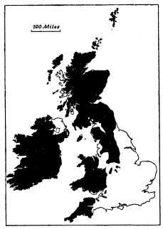
FIG. 1.—Highland Britain and Lowland Britain
Even the highest of the hills scarcely ever exceed a thousand feet above sea level, though many of the ridges reach 600 or 700 feet. The environment is kinder ; the soils tend to be deeper and richer, there are few steep slopes to interrupt cultivation and plough lands are to be found right to the tops of the hills. There is little to hinder man’s use of the whole: human settlement is essentially continuous and the cultivated land of one parish merges into that of the next. Villages and towns are closely and evenly scattered ; their siting has sometimes been dictated by convenience of a water supply, sometimes by situation on a natural routeway, sometimes just to maintain an even spacing of settlements. It follows that the greater part of Lowland Britain is occupied by farmland—by “cultivated” or “improved” land, which includes both plough and grass land—and that such moorlands, heaths, “wastes” and other unimproved lands as occur, do so as islands interrupting the otherwise continuous farmland and coinciding with patches of poorer soils.
It so happens that the rain-bearing winds in Britain blow from the west, especially from the south-west, and that the hill masses of Britain are in the west of the country. As a result Highland Britain as a whole gets a heavy rainfall, for the hills stand in the path of the rain-bearing winds, whilst most of the Lowland Britain is relatively dry. Taking a very general figure, most of Highland Britain gets more than 30 inches of rain a year while most of Lowland Britain gets less. Since the trouble with our climate is that we tend to get too much rain and too little sun it is clear that differences in climate reinforce those due to other features between Highland and Lowland Britain. In the far north-west, for example, where lowland does exist it is of comparatively little value because heavy rainfall and constant cloud result in water-logged conditions and almost useless bogs occur where otherwise good farmland might be found. The contrast in rainfall is shown in the accompanying map, while the effect of the combination of high ground and high rainfall is well brought out in Fig. 3 which shows the general distribution of moorland.
Although the chief visible contrasts between Highland and Lowland Britain are thus to be found in elevation, relief of the ground and soils, these are, in fact, the results of the underlying geological structure. The rocks which underly the hills are for the most part old even in the geological sense and in the course of ages have tended to become indurated and hard or at least resistant to weathering and hence tend to form hill masses rising above the general level. The rocks which underly the lowlands on the other hand are younger in the geological sense, though often very ancient if measured in years. They are softer or less resistant to weathering—there is evidence of this in the muddy streams to be seen after heavy rain, showing that soil or mud or silt is being swept off the land and carried seawards.
It happens that Highland Britain is made up mainly of rocks which are older than the Coal Measures (which contain the bulk of workable coal seams in this country) whereas Lowland Britain is made up mainly of rocks which are younger than the Coal Measures. It is for this reason that we find most of the coalfields of Britain on the margins of the highlands and the lowlands.
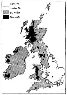
FIG. 2.—The Mean Annual Rainfall of the British Isles, showing the contrast between the wetter west and the drier east
The greatest of them all, the Yorkshire, Nottinghamshire and Derbyshire Coalfield, stretches up on to the Pennines and down on to the lowlands ; so do the coalfields of Lancashire and of Northumberland and Durham. The great South Wales field lies just north of the fertile Vale of Glamorgan and amongst the moorland heights.
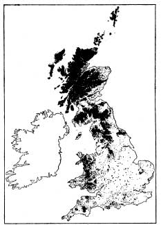
FIG. 3.—The Chief Moorland Areas of Great Britain, showing the close correspondence with areas of heavy rainfall (Fig. 2) and their association with Highland Britain
As a prelude to understanding the different regions of Britain and consequently the varied habitats in which our plants and animals live it is thus essential to understand. the geology and structure of the ground and to appreciate something of the long and complicated geological history of the country.
CHAPTER 2
READING THE ROCKS
IT HAS long been known that the solid rocks which build up the earth’s crust sometimes contain remains of animals and plants. A slab of shale from the tip-heap of a coal mine may be split open to reveal a beautifully preserved and delicate leaf which, whilst bearing a superficial resemblance to some ferns, on closer examination is found to be different from anything now living. In one of the literary classics which geology has given the English language the young Scottish stone-mason, Hugh Miller, has described the thrill of the chase when his hammer was used to make the Old Red Sandstone rocks give up entombed fragments—so clearly of fish yet so utterly different from their counterparts of the present day. Sometimes it is merely the footprint of some long-extinct reptile, sometimes the actual bones or teeth ; at other times it may be the remains of some minute creatures only revealed by the microscope which excite interest and inquiry into the origin of fossils, as all these remains of the animals and plants of the past are called.
Fossils were once hailed as incontrovertible evidence of the reality of Noah’s flood. Since it was soon made clear that they were to be found in different rocks and at different levels there arose the idea of several successive creations each in its turn overwhelmed by a great deluge. Forming as it were a mantle over many parts of the country are superficial deposits of clay, sand and gravel, to which reference will be made later. These “drift” deposits not infrequently contain shells and other fossils and the inference that these deposits were laid down by the latest flood was so obvious that they were called by the eighteenth century geologists “diluvium” (Latin, diluvium, a deluge or flood) or “diluvial deposits.”
A great advance was made when William Smith (1769 – 1839), who has very rightly been called the Father of English Geology, showed that the same fossils (i.e. different specimens of the same species) were to be found in different parts of the country, sometimes in the same type of rock but sometimes in rocks of different types. If several different species were associated together in one area then the same ones would be associated together in another. So he introduced the Law of Strata identified by fossils, and was able to produce the first geological map of England and Wales (published 1815). Two limestones from different parts of the country might appear to be very similar but if they contained different sets of fossils the inference was that they were of different ages. If on the other hand a sandstone from one region contained fossils identical with those from a shale in another the inference was that the two rocks were being formed at the same time—that they were of the same geological age or “synchronous” and could be “correlated.” It was found that when a species died out or “became extinct” it did not reappear in later rocks. Of course this was quite consistent with the idea of a succession of separate creations and it was not till much later that the theory of evolution permitted the tracing of the relationship between the fossils of one set of rocks and those of another.
The determination of the geological age of rocks by the fossils they contain is one of the two fundamental principles underlying the whole study of historical geology. The other is the Law of Superposition. Where one bed of rock rests upon another it is presumed that the upper bed was laid down after the lower and hence that the upper bed is the younger. A large proportion of the fossil-bearing rocks are sedimentary rocks (i.e. they were laid down as sediments under water—in the sea or in fresh-water)—and this law is true for nearly all such rocks. It is also true for streams of lava poured out from volcanoes or associated beds of ashes. Pompeii was there before the ashes by which the city was buried. But the Law of Superposition only remains true so long as the original order of the rocks has remained unchanged. With earthquakes and mountain-building movements the original order may be changed—the rocks may be folded, or even bent right over so that the original order is reversed. But reversal of the order in this way is the exception, not the rule, and can be detected by detailed survey. No one who has spent a holiday on the magnificent coast of north Cornwall can fail to have noticed how folded and broken are the rocks exposed along the sea cliffs. Examples are shown in Plates III and IV.
