 полная версия
History of Julius Caesar Vol. 2 of 2
490
491
Plate 22 shows the places which Cæsar’s eye could embrace from the summit of the Roche-Blanche. He could see neither the plateau, nor the country situated on the norther slopes of the mountains of Gergovia and Rissoles. It was for this reason that he had to learn from the deserters the form of the ground which lay on the other side. He thus learnt that the ridge of this latter mountain (dorsum ejus jugi) was not very uneven, and gave access to the western part of the town (ad alteram partem oppidi) by a narrow wooded passage (the defile of the Goules, which separates Rissoles from Gergovia). (See Plate 21 in C.) This defile leads to the gate P of the oppidum. The foundations, of masonry, and the approaches to this gate, were uncovered in the month of July, 1861. The wide road which led from this gate to the defile C is distinctly seen. The alarm of Vercingetorix may be imagined; he feared lest the Romans might shut up from the Gauls this issue from the oppidum. These latter would have been almost blockaded (pœne circumvallati), without any way out, and in the impossibility of producing forage from the valley of the Artières, since the northern part of the town was difficult to access. Consequently, the words si alterum collem amisissent can only apply to the mountain mass of Rissoles, and not, as several authors have pretended, to Montrognon or to Puy-Giroux; for the possession of those two peaks, detached and rather far from the mountain mass of Gergovia, offered no interest either for the attack or for the defence.
The spot which it was important for the Gauls to fortify was the part D E of the heights of Rissoles which are opposite the village of Opme, because troops could only scale the mass by the western slope. How can any one suppose that, fearing for the defile of the Goules, the Gauls would have abandoned their camp before the place to go and entrench themselves on Montrognon, three kilomètres from Gergovia? How admit that Cæsar, to threaten the defile, would have sent troops to make the circuit of the mountain of Gergovia by the north? How could the legion, which supported this movement, without advancing far, and which concealed itself in the woods, have assisted in the stratagem, if the false attack had been made to the east and to the north of Gergovia, at two leagues from the camp? In passing by the south, that is, by the defile of Opme, the legion was always in communication with the camps, on which it could fall back, and the broken and wooded ground prevented the Gauls from knowing accurately the importance of the attack. Besides, two facts which result from the “Commentaries” prove that the Gauls were not very far from the oppidum. Cæsar sees the southern front abandoned, and he establishes his legions at a distance of 1,200 paces from the place. The soldiers scale the heights at a rapid pace; but scarcely have they reached the principal enclosure, when the Gauls, who hear the cries of the women and of the small number of defenders left in the place (primo exaudito clamore), have time to hurry to them, and drive back the Romans. Consequently, the Gauls were at a distance where the cries could be heard; and this distance may be measured by the time which the attacking columns must have taken to climb the space of 1,200 paces, since they arrived almost simultaneously. We believe, therefore, that they were at a distance of less than two kilomètres from the gate O of the town, engaged in fortifying the plateau of the heights of Risolles.
492
According to Polyænus (VIII. xxiii. 9), the soldiers marched with their heads bent down, in order not to be seen.
493
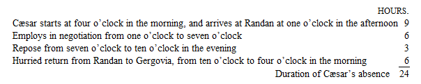
It is, in fact, 1780 mètres from the foot of the mountain, where Cæsar must have assembled his troops, between the Roche-Blanche and the Puy-de-Marmant, to the gate O of the oppidum. This is the line which passes by the ravine in which the village of Merdogne is situated; to the left and to the right the ground is too rugged for the troops to climb it.
494
General Gœler believes, with apparent reason, that we ought to read regressus instead of progressus. The 10th legion, which acted as reserve, must, in the presence of a combat, the issue of which was uncertain, have taken up a position behind rather than towards the front.
495
The part of the southern slope of Gergovia which was the scene of the last battle is clearly indicated by the ground itself. This battle took place on the whole space which extends in front of the gate O of the oppidum, the principal object of the attack. The ravine which, according to the “Commentaries,” prevented the legions from hearing the signal to retreat, is that which descends to the west of the Merdogne. Hence it may be concluded that, at this moment, Cæsar and the 10th legion were to the right of this ravine. Lastly, we understand on the spot the movement of the Ædui. To the east of Merdogne there is a spur, H, attached to the mountain of Gergovia, forty mètres below the table-land, and presenting several successive terraces. So long as the Ædui, who came from the east, had not arrived on the crest of this spur, they could not be perceived by the Romans, who were fighting towards Merdogne; but it may be imagined that, when they appeared all at once on this crest, and at a distance of 600 mètres from the right flank of the legions, the sight of them must have singularly surprised the troops, who were expecting no re-enforcement from that side.
General de Gœler, without having seen the locality, has indicated nearly the site of the Roman camp; but he does not place it sufficiently to the west. He makes the Gaulish troops encamp on the four slopes of the mountain of Gergovia. It is, no doubt, the expression circum se (VII. 36) which led him into this error. It is, indeed, impossible to admit that the Gauls could have encamped on the abrupt slopes of the northern declivity. General de Gœler is also mistaken in directing the false attack upon Montrognon. Lastly, he places the scene of the battle too much towards the west.
496
De Bello Gallico, VII. 52.
497
“In the war of the Gauls, Caius Julius Cæsar was surprised by an enemy, who carried him off, armed as he was, on his horse, when another Gaul, who recognized Cæsar, called out, intending to insult him, “Cæcos, Cæsar!” which in the Gaulish language signifies, let him go, set him loose; and so he escaped. Cæsar says so himself, in his Ephemerides, in the passage where he speaks of his good fortune.” (Servius Maurus Honoratus, a grammarian of the fifth century, in his commentary on the 11th book of the Æneid, line 743, II. p. 48, edit. Albert Lion.)
The manuscripts of Servius do not all present the same reading. The following are some of the principal variations: Cecos, Cæsar; Cæcos ac Cæsar; and Cæsar, Cesar.
498
Plutarch, Cæsar, 29.
499
There has always been a ford at Bourbon-Lancy.
500
De Bello Gallico, VII. 56.
501
A sling-ball of lead has been found at Sens, on which are stamped in relief the words “T. Labienus.” This ball forms part of the collection of the Museum of Saint-Germain.
502
MM. de Saulcy and J. Quicherat have already demonstrated in a conclusive manner that Labienus must have followed the left bank of the Yonne, after leaving Sens, and that he crossed over to the right bank of the Seine at Melun. In fact, Labienus, on the right bank, found himself, as Cæsar says, threatened on one side by the Bellovaci, on the other by the army of Camulogenus (VII. 59). On the opposite bank, on the contrary, Labienus would not have been placed between the two, since he would have had Camulogenus in front, and, at a greater distance, the Bellovaci coming from the north.
“A very large river kept the legions separated from their reserve and their baggage.” This very great river cannot be the Marne, which Cæsar does not even mention in the whole course of this campaign: it was evidently the Seine, which Labienus has crossed once only, at Melodunum (Melun); by crossing over to the right bank, he was separated from his base of operations, which was at Sens. On the contrary hypothesis, no river would have separated Labienus from his line of retreat; unless we admit, with Dulaure and several others, the identity of Agedincum with Provius, which is no longer possible.
The Captain of the Staff Rouby has made investigations on the spot, which prove that from Sens the most ancient ways leading to Paris passed on the left bank of the Yonne and of the Seine. Moreover, the discoveries of M. Carré have made us acquainted with the exact direction followed by the Roman road after quitting Sens towards Paris; it was entirely on the left bank of the Yonne. If Cæsar’s lieutenant had followed the right bank of the Yonne, he would, the day after his departure, have been arrested by the course of the Seine, and would have fallen in with the Gaulish town of Condate, built in the very angle of the two streams, in the midst of perhaps impassable marshes. If only a few thousand Gauls had occupied the heights which played so important a part in the campaign of 1814, Labienus, compelled to seek for a place to cross higher up the stream, would have been diverted considerably from his aim.
It has been supposed wrongly that the Bièvre was the marsh where Labienus, in his march on the left bank of the Seine, had been arrested by the Gaulish army. Leaving out of consideration the fact that the Bièvre, which flows through a calcareous soil, can at no epoch have formed a marsh capable of arresting an army, how can we suppose that Labienus, if he had arrived at this stream, that is, close to Lutetia, would have retraced his steps as far back as Melun, to march from thence towards the oppidum of the Parisii by the right bank of the Seine, which would have obliged him to make a journey of twenty-four leagues? The manœuvre of Labienus can only be explained by his desire to turn the strong position of Camulogenus, and arrive at Paris before him. The text of the “Commentaries” says clearly that Labienus, stopped by the marsh which shelves towards the Seine, stole away by night, surprised the passage of the Seine at Melun, and marched upon Lutetia, where he arrived before Camulogenus. To allow of the success of this manœuvre, the marsh in question must necessarily not have been far from Melun. The Essonne alone fulfils that condition. The ground on the banks of this little river offers, even at present, by its nature, a very serious obstacle to an army. It is cut up by innumerable peat mosses; and it was behind this line of Essonne that, in 1814, the Emperor Napoleon I. established his army, whilst the enemy occupied Paris.
503
We have not translated these words, fugam parare, because this passage has always appeared unintelligible to us. How, indeed, could the Gauls, seeing that the Romans were ready to pass the Seine by force, believe that this was a flight?
504
Some manuscripts have Metiosedum, a version which, in our opinion, is utterly incorrect.
505
De Bello Gallico, VII. 62.
506
See Appendix D.
507
De Bello Gallico, VII. 65. —Evocati was the name given to the old soldiers who, after having served, returned voluntarily to the ranks of the army.
508
Let us here recapitulate the numbers of the legions employed during the war in Gaul. Cæsar’s army, as we have seen, was composed in 696 of six legions, the 7th, 8th, 9th, 10th, 11th, and 12th. In 697, two new legions were raised in Italy, the 13th and 14th. Probably, in the winter between 699 and 700, Cæsar brought several cohorts composed of soldiers and sailors who were to serve in the fleet; for, on his return from the second expedition into England, notwithstanding the losses he had sustained, he was at the head of eight legions and five cohorts (V. 24). He lost at Aduatuca one legion and a half, that is, the 14th legion, besides five cohorts; but in 701 three new legions replaced the cohorts lost, and even doubled their number. These legions were the 1st, lent by Pompey (De Bello Gallico, VIII. 54, and Lucan, Pharsalia, VII., 1. 218); the 14th, which took the number of the legion destroyed at Aduatuca (De Bello Gallico, VI. 32; VIII. 4); and the 15th; this last legion was afterwards, with the 1st, given to Pompey for the war of the Parthians; it figured in the Civil War, and took, in Pompey’s army, the number 3. (Cæsar, De Bello Civili, III. 88.)
The 6th legion, judging from its number, must have been one of the oldest, for Dio Cassius (XXXVIII. 47) informs us that the legions were designated according to their order of inscription on the rolls of the army; but, as it only appears for the first time in 702, it is probable that it had remained in garrison among the Allobroges or in Italy. A proof that this legion assisted in the siege of Alesia is found in the fact that, after the surrender of the place, it was sent to winter quarters on the Saône, where Cæsar found it a few months afterwards (De Bello Gallico, VIII. 4). The distribution of the troops in their winter quarters after the taking of Alesia confirms the number of legions given above. The re-distribution after the siege of Uxellodunum gives also the same result, for in book VII. c. 46 the “Commentaries” give the positions of ten legions, without reckoning the 15th, which, according to book VIII. c. 24, had been sent to Cisalpine Gaul. These facts are repeated again, book VIII. c. 54.
509
It is evident that an army could not remain in the wars for eight years without receiving frequent re-enforcements in order to keep it up to its effective number. Thus, when, after the murder of Clodius, all the youth of Italy had been called to arms, Cæsar made new levies, which were used probably to swell the ranks of his legions, for no new numbers appear (De Bello Gallico, VII. 1). – In the same manner, when he arrived, in 702, in the south of Gaul, and crossed the Cévennes, he placed himself at the head of the troops which had been recruited in the Roman province and of the re-enforcements which he had brought from Italy (partem copiarum ex provincia supplementumque quod ex Italia adduxerat in Helvois, qui fines Arvernorum contingunt, convenire jubet). (De Bello Gallico, VII. 7.) – Labienus, on the other hand, during his expedition to Paris, left his recruits in dépôt at Sens (Labienus eo supplemento quod nuper ex Italia venerat relicto). (De Bello Gallico, VII. 57.)
510
Plutarch, Cato, 53.
511
Plutarch, Cæsar, 36.
512
See above, page 87.
513
See above, page 108, note (2).
514
We learn from the text that he formed three camps. This disposition was necessitated by circumstances and the character of the locality. The heights of Sacquenay form, in fact, three promontories, V, V, V (see Plate 24), advancing towards the north; the road to Dijon passes over the one to the left, the road to Pontallier over the one in the middle. By establishing three camps on these three promontories, Vercingetorix occupied each of these roads with one-third of his army, whilst he backed his right wing against the Vingeanne.
The Gaulish army had there a position of great natural strength, for, to attack it, the enemy would have to climb high hills which were easy to defend; it was, moreover, protected by two watercourses: one, the Vingeanne, which covered its right; the other, the Badin, a small tributary of the Vingeanne, which protected its front. In the space comprised between these two watercourses and the road from Dijon to Langres, a ground extends, measuring five kilomètres in every direction, slightly broken in some parts, but almost flat everywhere else, particularly between the Vingeanne and the hillock of Montsaugeon. Near the road, and to the west, arise hills which command it, as well as the whole country as far as Badin and the Vingeanne.
515
The field of battle of the Vingeanne, which H.M. Defay, of Langres, first pointed out, answers perfectly to all the requirements of the Latin narrative, and, moreover, material proofs exist which are undeniable evidences of the struggle. We allude to the tumuli which are found, some at Prauthoy, others on the banks of the Vingeanne, at Dardenay, and Cusey, and those which, at Pressant, Rivières-les-Fosses, Chamberceau, and Vesvres, mark, as it were, the line of retreat of the Gaulish army, to a distance of twelve kilomètres.
Two of these tumuli are situated near each other, between Prauthoy and Montsaugeon (see Plate 24, where the tumuli are marked). There is one near Dardenay, three to the west of Cusey, one at Rivières-les-Fosses, another at Chamberceau. We will not mention those which have been destroyed by agriculture, but which are still remembered by the inhabitants.
Researches lately made in these tumuli have brought to light skeletons, many of which had bronze bracelets round the arms and legs, calcined bones of men and horses, thirty-six bracelets, several iron circles which were worn around the neck, iron rings, fibulæ, fragments of metal plates, pieces of Celtic pottery, an iron sword, &c.
It is a fact worthy of remark, that the objects found in the tumuli at Rivières-les-Fosses and Chamberceau bear so close a resemblance to those of the tumuli on the banks of the Vingeanne, that we might think they had come from the hand of the same workman. Hence there can be no doubt that all these tumuli refer to one and the same incident of war. (Several of these objects are deposited in the Museum of Saint-Germain.)
We must add that the agricultural labourers of Montsaugeon, Isomes, and Cusey have found during many years, when they make trenches for drainage, horse-shoes buried a foot or two deep under the soil. In 1860, at the dredging of the Vingeanne, hundreds of horse-shoes, the inhabitants say, of excellent metal, were extracted from the gravel of the river, at a depth of two or three feet. They are generally small, and bear a groove all round, in which the heads of the nails were lodged. A great number of these horse-shoes have preserved their nails, which are flat, have a head in the form of a T, and still have their rivet – that is, the point which is folded back over the hoof – which proves that they are not shoes that have been lost, but shoes of dead horses, the foot of which has rotted away in the soil or in the gravel. Thirty-two of these horse-shoes have been collected. One of them is stamped in the middle of the curve with a mark, sometimes found on Celtic objects, and which has a certain analogy with the stamp on a plate of copper found in one of the tumuli of Montsaugeon.
When we consider that the action between the Roman and Gaulish armies was merely a cavalry battle, in which were engaged from 20,000 to 25,000 horses, the facts just stated cannot but appear interesting, although they may possibly belong to a battle of a later date.
516
We have adopted the reading, aciemque constitui jubebat, which alone gives a reasonable interpretation.
517
He was not the same as the one mentioned in pp. 307, 321, 320. (De Bello Gallico, VII. 67.)
518
The three Gaulish camps having been established on the heights of Sacquenay, four or five kilomètres behind the position occupied by the infantry during the battle, and the line of retreat towards Alesia lying to the left, in the direction of Pressant and Vesvres, if Vercingetorix had returned to ascend the hills with his 80,000 men, to remove the baggage, that operation would have taken two or three hours, during which Cæsar might have cut off his retreat, or have inflicted a still more serious defeat upon him. But, by immediately hastening his march on Pressant, in order to follow from thence the road which, by Rivières-les-Fosses and Vesvres, joined the great road from Langres to Alise, near Aujeur, he got in advance of the Roman army, which, in the disorder in which it was at that moment, was not able to pursue him at once. And this is what he did.
The text says, also, that Vercingetorix gave orders that the baggage should be taken out of the camps in all haste, to follow him. If the baggage of an army of 100,000 men had accompanied Vercingetorix, on the road followed by the infantry, we cannot understand how the Roman army, which pursued the Gauls as long as daylight lasted, should not have captured it all. But investigations made in the country situated between the field of battle and the Alise, behind the heights of Sacquenay, have brought to light vestiges of a Roman road which, starting from Thil-Châtel, thirteen kilomètres behind Sacquenay, proceeded, by Avelanges, towards the hamlet of Palus, where it branched from the road from Langres to Alise. We may suppose, therefore, that Vercingetorix caused his baggage to follow in his rear as far as Thil-Châtel, where it took the road to Palus.
The Roman road from Langres to Alise, which, without any doubt, marks the direction followed by the two armies, has been traced almost in its whole extent by Commandant Stoffel. Even at the present day, on the territories of Fraignot, Salives, Echalot, and Poiseul-la-Grange, the inhabitants call it the Road of the Romans, or Cæsar’s way.
519
We read (De Bello Gallico, VII. 68) the words, Altero die ad Alesiam castra fecit. We have before sought to prove that the words altero die must be translated by the second day after, and not by the next day. [See page 279, note (1).] It took Cæsar, therefore, two days’ march to move from the field of battle to Alesia.
A study of the country fully confirms the interpretation we give to the expression altero die. In fact, to the north and east of Alise-Sainte-Reine (Alesia), to less than two days’ march, the ground is so cut up and broken that no cavalry battle would be possible upon it. It retains this character as far as fifty-five or sixty kilomètres from Alise, to the east of the road from Pranthoy to Dijon, where it becomes more easy and open. The battle-field of the Vingeanne, which we consider as the true one, is at a distance of sixty-five kilomètres from Alise. Supposing that, on the day of the victory, the Roman army had pursued the Gauls over a space of fifteen kilomètres, it would have had to traverse in the two following days, before arriving at Alesia, a distance of fifty kilomètres, that is to say, twenty-five kilomètres a day.
520
We call the reader’s attention particularly to the numerous Roman and Gaulish coins found in one of the fosses of the camp D, the list of which will be found in Appendix C, at the end of this volume.
521
Near the western summit of the mountain two abundant springs arise; there is another on the eastern side. With these springs, as at Gergovia, it was easy to form large watering-places for cattle. Besides, manifest traces of a great number of wells are visible on the table-land, so that it is evident the besieged can never have wanted water, besides which, they could always descend to the two rivers.
522
We believe that these castella were palisaded redoubts having a recess attached, similar to the wooden blockhouses represented on the Trajan Column; often even these recesses alone composed the castellum.