 полная версия
History of Julius Caesar Vol. 2 of 2
3. From the plateau of Aire-la-Ville to the point of Epeisses, extent 6 kilomètres. – Down the river from the escarpments of Peney, the heights of the right bank (heights of Russin) form with those of the left bank an immense amphitheatre, nearly circular, the arena of which would be the ground represented green on Plate 3 (diameter, 1½ kilomètres). From the heights of Russin we can descend into the plain to the water of the river. The Rhone, in this part, has never been deep or rapid. The left bank is little elevated, entirely flat opposite the mill of Vert, and the slope of the heights which command it is far from impracticable.
Thus, it was here possible for the Helvetii to effect the passage of the river, and climb the heights of the left bank, if they had not been fortified or guarded. This operation presented least difficulty in the part t t o. And we can hardly doubt that the Romans fortified it to add to the natural obstacles, which were insufficient in this extent. (See the profile c c.)
An attentive examination of the locality, the discovery of certain irregularities of ground, which we may be allowed to consider as vestiges, lead us to explain in the following manner the expression murum fossamque perducit.
Cæsar took advantage of the mean heights at the foot of which the Rhone flows, to cause to be made, on the slope towards the river, and beginning with the crest, a longitudinal trench, of such a depth that the main wall had an elevation of 16 feet. The earth arising from the excavation was thrown down the side of the slope, and the crest was furnished with palisades. (See the profile of the retrenchment.) It was, properly speaking, a fosse, the scarp of which was higher than the counter-scarp.
The hills on the left bank, which rise opposite Russin, are accessible, especially in an extent of 900 mètres, reckoning from the point where the ravine which descends to Aire-la-Ville opens upon the river. They form there, among other peculiarities of the ground, a terrace 8 mètres in breadth, rising from 13 to 14 mètres above the plain, and descending to this by a tolerably uniform talus of 45 degrees.
The Romans would be able to prevent the access by means of the trench just described. They, no doubt, continued it to the point o, where the terrace ceases, and the heights become impracticable. It would then have been from 800 to 900 mètres long.
If we continue to descend the Rhone, we meet, on the left bank, first with the perpendicular escarpments of Cartigny, which are 70 or 80 mètres in height, and then abrupt beaches to near Avully. Below Cartigny, the Rhone surrounds a little plain, very slightly inclined towards the river, and presenting a projection of land (v r) from 5 to 6 mètres high, with a talus of less than 45 degrees. The bank being of small elevation, the Helvetii might have landed there. To prevent this, the Romans opened, in the talus which fronted the Rhone, a trench similar to the preceding; it was 250 mètres long.
The heights of Avully and Epeisses leave between them and the river a tolerably vast space, composed of two distinct parts. The first is formed of gentle slopes from Avully to a projection of land, q p; the other part is a plain comprised between this projection of land and the left bank of the river. On the right bank a torrent-like river, the London, debouches into flat ground named La Plaine. The Helvetii might have made their preparations for passing the Rhone there, and directed their efforts towards the western point of La Plaine, in face of the low and flat land comprised between the left bank and the escarpment q p. In this part the left bank is only from 1½ to 2 mètres high. Moreover, the slopes of Avully are not difficult to climb, and therefore the Romans must have sought to bar the passage in this direction. (See the broken profile d e f.) The escarpment q p, from its position and height, is easy to fortify. Its length is 700 mètres; its mean elevation above the plain, 18. It presents to the river a talus of less than 45 degrees. The Romans made in this talus, along the crest, a trench, forming wall and fosse. Its length was 700 mètres.
4. From the point of Epeisses to the escarpments of Etournel, extent 6 kilomètres. – From Epeisses to Chancy the Rhone flows in a straight line, and presents the appearance of a vast fosse, 100 mètres wide, the walls of which have an inclination of more than 45 degrees. (See the profile g g.)
At 200 mètres above Chancy, at k, the character of the banks changes suddenly. The heights on the right sink towards the river in tolerably gentle slopes, through an extent of 2,300 mètres, reckoning from k to the escarpments of Etournel. Opposite, on the left bank, extends the plateau of Chancy. It presents to the Rhone, from k to z, in a length of 1,400 mètres, an irregular crest, distant from 50 to 60 mètres from the river, and commanding it by about 20 mètres. The side towards the Rhone, from k to z, presents slopes which are very practicable. (See the profile h h.)
The position of Chancy was certainly the theatre of the most serious attempts on the part of the Helvetii. Encamped on the heights of the right bank, they could easily descend to the Rhone, and there make their preparations for passing, on an extent of 1,500 mètres. The river once crossed, they had only before them, from k to z, slopes which were practicable to debouch on the plateau of Chancy.
The Romans had then to bar the gap k z by joining the impassable escarpments which terminate in k with those which commence at z, and which are also inaccessible. To effect this, they opened from one of these points to the other, in the upper part of the slope at the foot of which the Rhone flows, a longitudinal trench k z, similar to that already spoken of. It was 1,400 mètres in length.
5. From the escarpments of Etournel to the Pas-de-l’Ecluse, an extent of 6 kilomètres. – At the escarpments of Etournel, the Rhone removes from the heights on the right, and only returns to them towards the hamlet of the Isles, 2 kilomètres farther down. These heights form a vast semi-elliptical amphitheatre, embracing a plain slightly inclined towards the river. It is marked by a green tint on Plate 3. People can descend from all sides and approach the Rhone, the bank of which is flat. Opposite, the left bank presents insurmountable obstacles until below Cologny, at s. But below this point, from s to y, the bank is flat, and the heights situated behind are accessible on an extent of 2 kilomètres.
The Helvetii, established on the heights of Pougny and Colonges, could descend to the Rhone, and cross it between Etournel and the hamlet of Les Isles. The Romans had thus to unite the escarpments which terminate at Cologny with the impracticable slopes of the mountain of Le Vuache. Here again we shall see that they took advantage of the peculiarities of the ground.
At the village of Cologny, the heights form a triangular plateau, s u x, of which the point s advances like a promontory towards the Rhone, which it commands perpendicularly by at least 20 mètres. A projection of land, s u, bounds it in front, and separates it from a plain which extends to the river. The escarpment produced by this projection of land presents to the Rhone a slope of about 45 degrees. It rises over the plain about 14 mètres towards its extremity s, but diminishes gradually in height, until it is only 2 to 3 mètres in height near the point u. (See the profile n n.) The Romans hollowed, on the slope of the escarpment from s to u, a length of 800 mètres, a trench forming wall and fosse. The plateau of Cologny, situated in the rear, offered a favorable position for the defence of this retrenchment. (See the profile p p.) They prolonged their works towards the west as far as y; beyond that, the heights presented sufficient natural obstacles. We may thus estimate that, from Cologny to the mountain of Le Vuache, the Romans executed from 1,600 to 1,700 mètres of retrenchments.
To sum up: the works executed on five principal points, between Geneva and the Jura, represent a total length of about 5,000 mètres, that is, less than the sixth part of the development of the course of the Rhone.
Admitting that Cæsar had at his disposal 10,000 men, we may suppose that he distributed them in the following manner: – 3,000 men on the heights of Avully, his head-quarters; 2,500 at Geneva; 1,000 on the plateau of Aire-la-Ville; 2,000 at Chancy; and 1,500 on the plateau of Cologny. These 10,000 men might be concentrated: in two hours, on the heights between Aire-la-Ville and Cartigny; in three hours, on the heights of Avully; in three hours and a half, on the plateau of Chancy; in three hours and a half, these troops, with the exception of those encamped at Geneva, might be brought together between Cologny and the fort of L’Ecluse. It would require five hours to carry the detachment from Geneva thither.
The detachments mentioned above, with the exception of that of Geneva, were established in what Cæsar calls the castella. These were constructed on the heights, in the proximity of the retrenchments which had to be defended – namely, at Aire-la-Ville, Avully, Chancy, and Cologny. They consisted probably of earthen redoubts, capable of containing a certain number of troops. They are represented by squares in Plate 3.
Cæsar could reconnoitre every instant the march and designs of the Helvetii, the heights of the left bank of the Rhone presenting a great number of positions where it was easy to place advantageously posts of observation. Commandant Stoffel has pointed out six, which are marked on Plate 3. As it will be observed, the Helvetii, in crossing the Rhone, could not be disturbed by darts thrown from the top of the retrenchments, for these darts would not carry to the left bank of the river. Now there exists at present, between this bank and the foot of the heights in which these trenches were cut, flat ground of more or less extent. Admitting, then, that the Rhone flowed nineteen centuries ago in the same bed as at the present day, we may ask if the Romans did not construct, in these low parts near the bank, ordinary retrenchments, composed of a fosse and rampart. The excavations undertaken by the Commandant Stoffel have revealed everywhere, in these plains, the existence of ground formed by alluvium, which would lead us to believe that the Rhone once covered them. However, even if at that epoch these little plains had been already uncovered, either wholly or in part, we can hardly suppose that Cæsar would have raised works there, since the heights situated in the rear permitted him, with less labour, to create a more redoubtable defence – that of the trenches opened along the crests. As we see, the obstacle presented to the assailants began only with these trenches, at the top of the slopes.
As to the vestiges which still appear to exist, they may be described as follows. The slopes which the Romans fortified at Chancy, from k to z, and at Cologny, from s to y, present, in the upper parts, in some places, undulations of ground, the form of which denotes the work of man. On the slope of Chancy, for instance, the ground presents a projection, i i (see the profile h h), very distinctly marked, and having the remarkable peculiarity that it is about 11 feet high and 8 to 9 feet broad. Now, is it not evident that, if one of the fosses which have been described should get filled up, either naturally, by the action of time, or by the processes of agriculture, it would take absolutely the form i i, with the dimensions just indicated? It would not, therefore, be rash to consider these peculiarities of the ground, such as i i, as traces of the Roman trenches.
We must further mention the projection of land v r, situated below Cartigny. Its form is so regular, and so sharply defined, from the crest to the foot of the talus, that it is difficult not to see in it the vestiges of a work made by men’s hands.
It is easy to estimate approximately the time which it would have taken Cæsar’s troops to construct the 5,000 mètres of trenches which extended, at separate intervals, from Geneva to the Jura.
Let us consider, to fix our ideas, a ground A D V, inclined at 45 degrees, in which is to be made the trench A B C D. The great wall A B C had 16 Roman feet in elevation: we will suppose that A B was inclined at 5 on 1, and that the small wall D C was 6 feet high.
The amount of rubbish removed would be as follows: – Section A B C D = 64 square feet, or, reducing it into square mètres, A B C D = 5 square mètres 60 centimètres.
The mètre in length of the earth thrown out would give thus 5·60 cubic mètres.
If we consider the facility of labour in the trench, since the earth has only to be thrown down the slope, we shall see that two men can dig three mètres in length of this trench in two days. Therefore, admitting that the 10,000 men at Cæsar’s disposal had only been employed a quarter of the time, from two to three days would have been sufficient for the execution of the complete work.
166
De Bello Gallico, I. 8.
167
De Bello Gallico, I. 9. – The country of the Sequani comprised the Jura, and reached to the Pas-de-l’Ecluse. (See Plate 2, Map of Gaul.)
168
It has been considered to have been an error of Cæsar to place the Santones in the proximity of the Tolosates: modern researchers have proved that the two peoples were not more than thirty or forty leagues from each other.
169
Several authors have stated wrongly that Cæsar went into Illyria; he informs us himself (De Bello Gallico, III. 7) that he went thither for the first time in the winter of 698.
170
We believe, with General de Gœler, from the itinerary marked on the Peutingerian table, that the troops of Cæsar passed by Altinum (Altino), Mantua, Cremona, Laus Pompei (Lodi Vecchio), Pavia, and Turin; but, after quitting this last place, we consider that they followed the route of Fenestrella and Ocelum. Thence they directed their march across the Cottian Alps, by Cesena and Brigantium (Briançon); then, following the road indicated by the Theodosian table, which appears to have passed along the banks of the Romanche, they proceeded to Cularo (Grenoble), on the frontier of the Vocontii, by Stabatio (Chahotte or Le Monestier, Hautes-Alpes), Durotineum (Villards-d’Arenne), Melloseeum (Misoen or Bourg-d’Oysans, Isère), and Catorissium (Bourg-d’Oysans or Chaource, Isère).
171
“Locis superioribus occupatis.” (De Bello Gallico, I. 10.)
172
There is difference of opinion as to the site of Ocelum. The following remark has been communicated to me by M.E. Celesia, who is preparing a work on ancient Italy: Ocelum only meant, in the ancient Celtic or Iberian language, principal passage. We know that, in the Pyrenees, these passages were called ports. There existed places of the name of Ocelum, in the Alps, in Gaul, and as far as Spain. (Ptolemy, II. 6.) – The itineraries found in the baths of Vicarello indicate, between Turin and Susa, an Ocelum, which appears to us to have been that of which Cæsar speaks; there was a place similarly named in Maurienne, on the left bank of the Arc, at an equal distance from the source of that river and the town of Saint-Jean; it is now Usseglio. There was another in the valley of the Lanzo, on the left bank of the Gara, from which appears to be derived the name of Garaceli or Graioceli; it was called Ocelum Lanciensium. The Ocelum of Cæsar, according to M. Celesia, who adopts the opinion of D’Anville, was called Ocelum ad Clusonem fluvium; it was situated in the valley of the Pragelatto, on the road leading from Pignerol to the defile of Fenestrella. This place has continued to preserve its primitive name of Ocelum, Occelum, Oxelum, Uxelum (Charta Adeladis, an. 1064), whence by corruption its modern name of Usseau. According to this hypothesis, Cæsar would have passed from the valley of Chiusone into that of Pragelatto, and thence, by Mount Genèvre, to Briançon, in order to arrive among the Vocontii. – Polyænus (Stratag., VIII. xxiii. 2) relates that Cæsar took advantage of a mist to escape the mountaineers.
173
“Segusiavi sunt trans Rhodanum primi.” (De Bello Gallico, I. 10.) It is to be supposed that there existed a bridge on the Rhone, near Lyons.
174
Cæsar had deferred his reply till the Ides of April (April the 8th). If it were then decided to bring the legions from Aquileia, the time necessary to bring them would have been as follows:
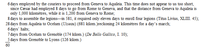
According to this reckoning, Cæsar required 60 days, reckoning from the moment when he decided on this course, to transport his legions from Aquileia to Lyons; that is to say, if he sent, as is probable, couriers on the 8th of April, the day he refused the passage to the Helvetii, the head of his column arrived at Lyons towards the 7th of June.
175
To estimate the volume and weight represented by the provisions for three months for three hundred and sixty-eight thousand persons of both sexes and of all ages, let us allow that the ration of food was small, and consisted, we may say, only in a reserve of meal, trium mensium molita cibaria, at an average of ¾ of a pound (¾ of a pound of meal gives about a pound of bread); at this rate, the Helvetii must have carried with them 24,840,000 pounds, or 12,420,000 kilogrammes of meal. Let us allow also that they had great four-wheeled carriages, capable each of carrying 2,000 kilogrammes, and drawn by four horses. The 100 kilogrammes of unrefined meal makes 2 cubic hectolitres; therefore, 2,000 kilogrammes of meal make 4 cubic mètres, so that this would lead us to suppose no more than 4 cubic mètres as the average load for the four-wheeled carriages. On our good roads in France, levelled and paved, three horses are sufficient to draw, at a walking pace, during ten hours, a four-wheeled carriage carrying 4,000 kilogrammes. It is more than 1,300 kilogrammes per collar.
We suppose that the horses of the emigrants drew only 500 kilogrammes in excess of the dead weight, which would give about 6,000 carriages and 24,000 draught animals to transport the three months’ provisions.
But these emigrants were not only provided with food, for they had also certainly baggage. It appears to us no exaggeration to suppose that each individual carried, besides his food, fifteen kilogrammes of baggage on an average. We are thus left to add to the 6,000 provision carriages about 2,500 other carriages for the baggage, which would make a total of 8,500 carriages drawn by 34,000 draught animals. We use the word animals instead of horses, as at least a part of the teams would, no doubt, be composed of oxen, the number of which would diminish daily, for the emigrants would be led to use the flesh of these animals for their own food.
Such a column of 8,500 carriages, supposing them to march in file, one carriage at a time, on a single road, could not occupy less than thirty-two leagues in length, if we reckon fifteen mètres to each carriage. This remark explains the enormous difficulties the emigration would encounter, and the slowness of its movements: we need, then, no longer be astonished at the twenty days which it took three quarters of the column to pass the Saône.
We have not comprised the provisions of grain for the animals themselves: yet it is difficult to believe that the Helvetii, so provident for their own wants, had neglected to provide for those of their beasts, and that they had reckoned exclusively for their food on the forage they might find on the road.
176
De Bello Gallico, I. 11.
177
It is an error to translate Arar, quod per fines Æduorum et Sequanorum in Rhodamam influit, by the words, “the Saône, which forms the common boundary line of the Ædui and the Sequani.” Cæsar always understands by fines, territory, and not boundary line. He expresses himself very differently when he speaks of a river separating territories. (De Bello Gallico, I. 6, 83; VII. 5.) The expression per fines thus confirms the supposition that the territories of these two peoples extended on both sides of the Saône. (See Plate 2.)
178
De Bello Gallico, I. 12. – The excavations, carried on in 1862 between Trévoux and Riottier, on the plateaux of La Bruyère and Saint-Bernard, leave no doubt of the place of this defeat. They revealed the existence of numerous sepulchres, as well Gallo-Roman as Celtic. The tumuli furnished vases of coarse clay, and many fragments of arms in silex, ornaments in bronze, iron arrow-heads, fragments of sockets. These sepultures are some by incineration, others by inhumation. In the first, the cremation had nowhere been complete, which proves that they had been burnt hastily, and excludes all notion of an ordinary cemetery. Two common fosses were divided each into two compartments, one of which contained cinders, the other human skeletons, thrown in pell-mell, skeletons of men, women, and children. Lastly, numerous country ovens line, as it were, the road followed by the Helvetii. These ovens, very common at the foot of the abrupt hills of Trévoux, Saint-Didier, Frans, Jassans, and Mizérieux, are found again on the left bank of the Ain and as far as the neighbourhood of Ambronay.
179
Cæsar declares, on two different occasions, the fixed design of the Helvetii to establish themselves in the country of the Santones (I. 9 and 11), and Titus Livius confirms this fact in these words: “Cæsar Helvetios, gentem vagam, domuit, quæ, sedem quærens, in provinciam Cæsaris Narbonem iter facere volebat.” (Epitome, CIII.) Had they, for the execution of this project, the choice between several roads (the word “road” being taken here in the general sense)? Some authors, not considering the topography of France, have believed that, to go to the Santones, the Helvetii should have marched by the shortest line, from east to west, and passed the Loire towards Roanne. But they would have had first to pass, in places almost impassable, the mountains which separate the Saône from the Loire, and, had they arrived there, they would have found their road barred by another chain of mountains, that of Le Forez, which separates the Loire from the Allier.
The only means of going from the Lower Saône into Saintonge consists in travelling at first to the north-west towards the sources of the Bourbince, where is found the greatest depression of the chain of mountains which separates the Saône from the Loire, and marching subsequently to the west, to descend towards the latter river. This is so true, that at an epoch very near to our own, before the construction of the railways, the public conveyances, to go from Lyons to La Rochelle, did not pass by Roanne, but took the direction to the north-west, to Autun, and thence to Nevers, in the valley of the Loire. We understand, in exploring this mountainous country, why Cæsar was obliged to confine himself to pursuing the Helvetii, without being ever able to attack them. We cannot find a single point where he could have gained upon them by rapidity of movement, or where he could execute any manœuvre whatever.
180
The Romans used little precision in the division of time. Forcellini (Lex., voce Hora) refers to Pliny and Censorinus. He remarks that the day – that is, the time between the rising and setting of the sun – was divided into twelve parts, at all seasons of the year, and the night the same, from which it would result that in summer the hours of the day were longer than in winter, and vice versa for the nights. – Galenus (De San. Tuend., VI. 7) observed that at Rome the longest days were equal to fifteen equinoctial hours. Now, these fifteen hours only reckoning for twelve, it happened that towards the solstice each hour was more than a quarter longer than towards the equinox. This remark was not new, for it is found in Plautus. One of his personages says to a drunkard: “Thou wilt drink four good harvests of Massic wine in an hour!” “Add,” replied the drunkard, “in an hour of winter.” (Plautus, Pseudolus, v. I, 302, edit. Ritschl.) – Vegetius says that the soldier ought to make twenty miles in five hours, and notes that he speaks of hours in summer, which at Rome, according to the foregoing calculation, would be equivalent to six hours and a quarter towards the equinox. (Vegetius, Mil., I. 9.)