Полная версия
Scotland
Important amounts of sediment were also deposited by sediment-charged meltwaters flowing out from retreating glaciers, referred to as glaciofluvial deposits, and present in a variety of forms. Sediment may accumulate in channels, ponds and lakes trapped between lobes of glacier ice or between a glacier and the valley side. Where such sediment has a ridge or mound form, it is termed a kame; where it is a flat-topped mound, it is termed a kame terrace, and is likely to have been deposited in a lake. When sub-glacial meltwater drains through tunnels, the sub-glacial stream may deposit sediment as a surface stream would, but confined to the tunnel. The result is a long sinuous ridge of gravel, termed an esker. Outwash plains often build up downstream of the melting glacier, large plains of poorly sorted, stratified sediment deposited by braided streams. Sequences of terraces are often seen in these plains, formed by river incision. Kettle holes are also common features, formed by blocks of ice that become buried in outwash sediment, and then melt to leave behind a depression. Many of these kettles have been infilled with sediments, particularly peat, during the post-glacial times, but some are still visible today as small isolated lakes or deep water-filled depressions in boggy areas that were once the low-lying outwash plains.
A famous example of ‘kame-and-kettle topography’ is found in Nithsdale, north of Dumfries. Particularly on the eastern side of the valley, there are many short, linear glaciofluvial ridges separated by depressions and hollows. The relative relief between ridge crest and depression is usually between 8 and 25 m, and the ridges are relatively short, with very few being over 500 m long. The extensive gravel pit at Kilblane, for example, is developed in three such kame ridges. The coarse sediment that makes up these ridges, and other linear kame ridges in this part of Nithsdale, was probably deposited in meltwater channels that flowed between ice-cored ridges parallel to the ice margin. As the ice ridges melted, the sediment-filled channels became inverted to produce the kames seen today. Kame terraces are also seen on both sides of the Nith, with the best developed just east of Duncow (8 km north of Dumfries) at an altitude of around 55 m. Further north, in the mid-part of the Nith valley (south of Thornhill), a similar kame-and-kettle topography is seen. The glaciofluvial deposits of Nithsdale account for the rather large number of sand and gravel pits seen just north of Dumfries, now often flooded. Glaciofluvial deposits are relatively common elsewhere in Areas 1 and 2, such as in many of the valleys on the south side of the Southern Uplands and in the area around Stranraer.
The mapping of glaciofluvial deposits in the Nith Valley has allowed the reconstruction of the pattern of glaciofluvial drainage which developed during a late stage of deglaciation. The result shows a narrow marginal zone of ice-cored ridges and troughs in the north, feeding meltwater and sediments to the ice front north of Dumfries. This ice front is marked by a terminal moraine across the Nith valley, which is crossed by the River Nith in a gorge in Dumfries. Further southeast, the drainage fed outwash systems in the Lochar Water and Nith valleys. Today, this outwash plain underlies much of the uniformly flat surface southwest of Dumfries.
A closer look at Late Devensian ice-flow directions
The broad ice-flow pattern shown in Figure 53 is useful, but presents a highly generalised picture; in reality, ice-flow directions over the course of the Late Devensian were somewhat more complicated. The large number of streamlined glacial deposits found throughout Area 1, particularly in the lowlands, has allowed a much more detailed reconstruction of Devensian ice flow. A recent study looked in detail at the glacial features present in the western part of Area 1, in particular at drumlins, erratic trains and glacial striae. It was found that several generations of these features can often be seen superimposed on one another, recording multiple passages of ice from different ice centres. These changing flow directions are summarised in Figure 54, and record the changing relative strengths of the Southern Uplands and Highlands ice centres.
Some of the earliest features in the western Southern Uplands indicate that ice from the Highlands was initially dominant during the Late Devensian, when it streamed southwards from the Firth of Clyde and crossed the Glenluce lowlands, producing north/south lineations. This Highland ice was then replaced over much of Area 1 by Southern Uplands ice, as shown by a southwest-oriented flow set running across Glenluce and the southern Rhins. A similar story is recorded by till deposits in the southern Midland Valley, around the margins of the Southern Uplands. For example, a vertical section cut by the River Nith at Nith Bridge, just south of Cumnock, reveals three tills deposited during the Late Devensian and separated by glaciofluvial sands and gravels. These tills have been carefully studied, and the bottom two were both found to have been deposited by Highland ice, which probably flowed across central Ayrshire from the Firth of Clyde area. The topmost till, by contrast, was deposited by ice originating in the Southern Uplands. There were, therefore, at least two distinctive phases of ice movement across central Ayrshire, with an initial advance of Highland ice being succeeded by Southern Uplands ice. The evidence at Nith Bridge matches similar evidence found across the southern Midland Valley, and the story indicated by streamlined landforms further southwest. It seems, therefore, that Highland ice initially expanded to encroach on the Southern Uplands, and that it was only as glaciation progressed that Southern Uplands ice became more dominant in Area 1. Further south, another major ice centre was established in the Lake District, and converging drift lineations at the tip of the Machars peninsula mark the confluence of this and Southern Uplands ice.
At the coldest stage of the last glaciation, around 20,000 years ago, Highland ice one again played a role – an ice stream flowed out from the Highlands and along the western seaboard of Area 1. As the ice moved down the Firth of Clyde, it scraped marine deposits off the sea bed and re-deposited them further south. These shelly deposits are found, for example, on top of a 10 m-high shore platform around the Mull of Galloway. The Highlands ice sheet also brought glacial erratics of the distinctive Ailsa Craig microgranite and Arran granite southwards, found today throughout the Rhins peninsula.
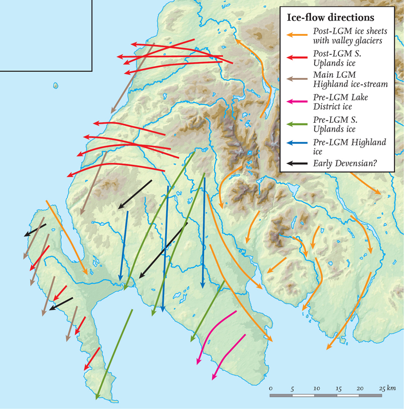
FIG 54. More detailed examination of local ice-flow directions during the Devensian (LGM is the Late Glacial Maximum that occurred late in the Devensian). After Salt and Evans, 2004
Following the glacial maximum, climate began to warm, and both the Southern Uplands and Highland ice centres contracted. Some time after Highland ice had retreated from the western seaboard, a phase of local ice expansion interrupted the general waning, and Southern Uplands ice once again flowed across the western part of Area 1. For much of the western, lowland parts of this Area, this would be the last time they were ice-covered, and the ice sheet left behind the extensive drumlin swarms described above. This Southern Uplands ice flowed southwestwards across the Rhins of Galloway, bringing with it erratics of Loch Doon granite. It also flowed roughly westwards across the Ballantrae and Girvan districts. In the Ballantrae area, flow was somewhat valley-contained, showing that the ice sheet was much thinner than it had been during the glacial maximum. Further north around Girvan, the lineations are particularly notable for their cross-cutting relationships, probably produced by the slight shifting in the main ice-dispersal centre with time.
The most recent flow set was also produced during the waning of the Southern Uplands ice sheet, again during a minor re-advance. This time, valley glaciers radiated out from a Southern Uplands dispersal centre located around Merrick, down valleys such as Nithsdale, Glenluce and northwards into the Midland Valley. Again, erratic trains from distinct granite outcrops around the Galloway area provide useful trackers, along with moraine ridges and drumlins. A local surge of Highland ice down Loch Ryan also occurred at this time, and a prominent moraine at the head of Loch Ryan (the Stranraer moraine) marks the outer limit of this re-advance.
Pollen and beetle records indicate that temperatures in Area 1 may have risen to as warm as present by around 13,000 years ago, by which time southwest Scotland must have been completely deglaciated. Temperatures then fell sharply around 12,000 years ago, culminating in the Loch Lomond Stadial. This climatic deterioration was accompanied by the return of glaciers to parts of the Southern Uplands, although these glaciers were of very limited extent, generally being confined to the highest corries. Where glaciers developed, they bulldozed earlier till deposits into moraine ridges. A fine example of one such moraine is seen at Loch Dungeon, just southeast of Corserine. Steep cliffs of Silurian sediments rise from the southeast shore of the loch, and a subsidiary corrie of Corserine opens out on the northwest shore. A glacier emerged from this corrie, and its terminus is marked by a large terminal moraine to the west of the loch and by a shallow area within the loch itself.
Even in unglaciated upland areas, ice growth often caused extensive frost shattering. The scree and loose rock this produced is still visible today, particularly on summits and upper slopes, and has often been modified by subsequent flow to form a series of lobes and sheets. Elsewhere in the lowlands, the cold climate of the Loch Lomond Stadial made itself felt through the development of permafrost, as evidenced today by features such as ice wedge casts, seen most commonly in gravel pits. Evidence for periglacial disturbance and movement of the soil (solifluction) is also widespread on lowland slopes, usually affecting 1–2 m depth of soil, though in the valley floors of the Southern Uplands, great thicknesses of solifluction deposits have accumulated.
Post-glacial landscape development
At the end of the Loch Lomond Stadial, a temperature rise of around 7 °C occurred within just 700 years, marking the start of the current Flandrian (or Holocene) period. Although the effects of glaciation still dominate much of the landscape, in the 10,000 years since the disappearance of the last glaciers the land surface has been slowly adjusting to non-glacial conditions. These changes are particularly evident in areas of high relief, where glacial retreat exposed a bare rock landscape with over-steepened slopes. Soon after deglaciation, this landscape began adjusting to the new conditions, with rock falls, debris flows and reworking of glacial sediments. As the landscape re-equilibrated and soils and stabilising vegetation became established, it seems that these processes almost stopped, as shown by the vegetated, relict nature of most of the talus slopes, debris cones and alluvial fans in this Area.
Today, Area 1 is notable for its variety of river types and sizes, reflecting contrasts in relief and catchment size throughout the Area. Most of the main rivers originate in the high ground of the Southern Uplands and drain southwards, including the Nith, Cree and Dee (Fig. 51). The upland tributaries of these rivers are akin to mountain torrents, becoming wandering gravel-bed rivers in their middle reaches as the relief becomes more subdued. Most of the major rivers have highly sinuous, meandering courses in their lower reaches, and drain into silty estuaries in the Solway Firth (Fig. 55). The River Ayr, in the Midland Valley, has one of the most meandering courses in this Area, as it weaves across a flat lowland strewn with glacial deposits. Many of the lower reaches of the watercourses in this Area have been embanked to prevent flooding of adjacent land, and some of the smaller rivers show signs of having been straightened in the past.
The first vegetation to become established early in the Holocene was a juniper-dominated community, followed by birch and hazel around 9000 years ago, and then by oak and elm during the middle Holocene. Pine forest was present in the Galloway Hills, but was never the dominant species in this Area. From around 5000 years ago, human activity first began to have a significant impact on the landscape, primarily through forest clearance to make way for agriculture. There is evidence that woodland began to be progressively replaced by peat around 5000 years ago, and that by around 4200 years ago forest cover had essentially disappeared from the Area, replaced by blanket mire. This deforestation is thought to have led to enhanced soil erosion, with an increase in slope failure, debris flow activity and river incision. Peat has been the most widespread soil type in Area 1 since around 4000 years ago, in the form of blanket bog (including the internationally important Silver Flowe Bog in the low ground of the Loch Doon intrusion), or drier heather-covered slopes.
More recently, damming is another way in which humans have significantly altered parts of Area 1, flooding valleys to create reservoirs. The Galloway hydroelectric scheme was built between 1930 and 1936, and was the first of its kind in Scotland. Although small compared to some of the later Highland schemes, it is a model of unobtrusive and ecologically sensitive hydroelectric engineering, and is studied by engineers from around the world. Making use of water principally stored in Loch Doon, Clatteringshaws Loch and Loch Ken, the scheme includes eight dams, 12 km of tunnels, aqueducts and pipelines together with six power stations along 130 km of river. Whilst Loch Doon is on the site of a natural loch, damming has increased the water level by some 9 m, submerging various small islands. Before the Loch Doon dam was built, Loch Doon Castle, a thirteenth-century castle originally located on an island in the centre of the loch, was moved, stone by stone, to the adjacent bank where it now stands. Elsewhere, dam building flooded valleys, thereby significantly altering the landscape. Such reservoirs include Clatteringshaws Loch and Loch Ken on the Water of Ken. Loch Ken is now a major nature reserve and a breeding ground for many varieties of wild birds.
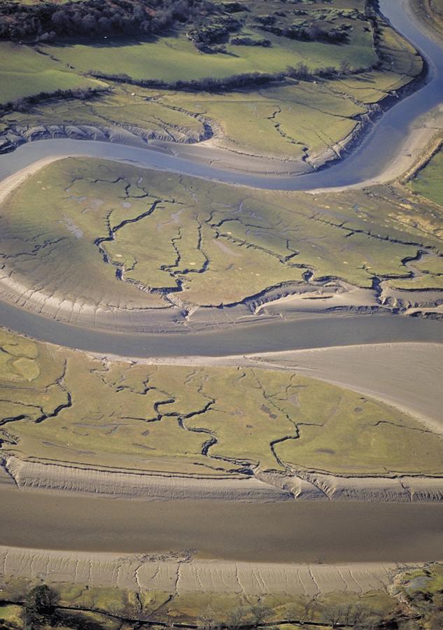
FIG 55. Tidal marshes showing typical, highly sinuous channels, where the wavelength of the channels cut in the muddy sediments reflects the tidal discharges involved. (© Patricia & Angus Macdonald/Aerographica/Scottish Natural Heritage)
Man has also altered the landscape by mining and quarrying activities, particularly prevalent in the Midland Valley where large opencast coal workings are still operational today in places, such as east of Patna. Recent clean-up efforts have greatly reduced the impact of colliery tips (bings) on the landscape, such as northeast of Girvan, where they have been landscaped and forested. Local stone has also been quarried for building stone, roadstone and crushed rock aggregate. An important source of building stone is the area around Mauchline, from which the attractive orange-red Permian sandstone has been extracted. Stone from this area has been widely used throughout the UK and Ireland, and even shipped to the USA. The granites have also been economically important for the region – the Glasgow and Liverpool docks, for example, were constructed using Criffel–Dalbeattie granite. Glacial sands, silts and gravels have also frequently been quarried, often leaving their mark on the landscape with flooded gravel pits.
Today, the Area is generally very wet and mild, as the North Atlantic Drift maintains higher temperatures than those found on the east coast. Indeed, plants normally associated with more southerly latitudes are found on the Rhins, along with dolphins and basking sharks off the coast. Much of the Southern Uplands in this Area lie within the Galloway Forest Park, managed by the Forestry Commission, and as well as rolling moorland, conifer plantations are common on the shallow, poor soils. The main river valleys (such as the Urr, Dee, Cree and Nith) provide a contrast to this rolling moorland, providing much of the good arable land of the Southern Uplands.
The formation of the coastline
As described in Chapter 5, sea level in much of Scotland has not been constant, but has risen and fallen according to the interplay between global sea level and the elevation of the land. Global sea level decreases during an ice age, as water is locked up within the ice, and rises again as this ice melts. Meanwhile, during glacials, the crust becomes depressed locally under ice sheets, sinking into the mantle, and slowly rebounds once this ice has melted. The sea level at the coast at any one time therefore depends on the interplay between these two effects, and in the past sea level in Area 1 has been both higher and lower than at present. When sea level has remained constant for long enough, shorelines formed – marked today by erosional features such as rock-cut platforms backed by cliffs, or by beach deposits. Where subsequent uplift has outstripped global sea-level rise, these shorelines now take the form of raised beaches, raised deltas, raised estuarine deposits (known in Scotland as carse), and raised rock platforms and cliffs. Good examples of these features are found in this Area. Shore platforms are relatively common on stretches of rocky coastline, and are particularly well developed, for example, between the Heads of Ayr and Turnberry and around Ballantrae. In the latter area, numerous small caves and gullies often delineate the foot of the cliff, and occasional raised sea stacks rest on the raised platform. Further south, a shore platform can be traced around most of the Mull of Galloway at approximately 10 m above present sea level, and deposits of glacial till on top of it show that it predates the Devensian glaciation. In places, several shorelines are present, such as some 8 km southwest of Girvan, where two old shorelines give the skyline a stepped profile. These shorelines occur as a series of benches, commonly cut into boulder clay. Mafic, dolerite dykes have been etched out by the sea during the formation of each of these shorelines, and today stand as raised sea stacks.
In the lower-lying coastal areas, past increases in sea level involved the flooding of sometimes large patches of land. For example, along the Ayrshire coast the late glacial sea was nearly 30 m higher than at present, and so the sea would have come several kilometres inland from its present position. Along the Solway coast in the south of the Area, large sections of the present shore are backed by raised estuarine deposits of silt and clay, which provide valuable records of this sea-level change over the last 15,000 years. Good examples occur flanking the heads of the Cree and Fleet estuaries, which in this area lie between 7 and 10 m above present sea level.
The sediments within cores taken from the carselands flanking the Cree estuary have been analysed and dated, and have proved very useful in reconstructing the sea-level history of the Solway Firth, as summarised in Figure 56. These deposits show that sea level rose to cover this area by around 9600 years ago, followed by a rise to the so-called Main Post-glacial Shoreline by 6500 years ago, when sea levels were between 7 and 10 m above present and some 9 m of estuarine deposits were laid down in the Cree area. Sea level then fell from the uppermost carse surface to its present level as the land continued to rebound, whilst worldwide sea volume changed very little.
The large-scale shape of the coastline is controlled by a number of factors, many of which are in turn related to one another. Rising sea levels cause valleys to become flooded, forming bays and islands, whilst the location of these valleys often reflects rock type (i.e. hardness) and structure (both the presence of jointing within a rock unit and lines of weakness, such as faults). Climate and tidal energy also play an important role, controlling wave energy environments and terrestrial processes, such as sediment supply. The amount of sediment supply to a coast of course depends on the availability of that sediment, and in this regard glaciation has been very important. At the end of the Devensian, great volumes of glacial debris were deposited on the continental shelf. As sea level recovered to present levels, this sediment was reworked and moved towards the shore, to form the basis of our present beach and sand-dune systems. Today, where sediment supply is abundant, the coastline is currently advancing seawards, whilst in areas where sediment supply is in decline, the coastline is usually retreating through erosion. Humans, also, can have an impact – for example through building, quarrying, constructing sea defences and trampling of stabilising vegetation.
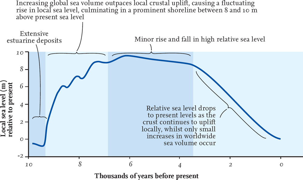
FIG 56. Sea-level curve for the Solway Firth. (Data from Smith et al. 2003, Transactions of the Royal Society of Edinburgh: Earth Sciences, 93, 301–31)
The number of large bays is one of the more obvious features of the coastal strip of Area 1. The main ones are Loch Ryan and Luce Bay, which together define the Rhins of Galloway, and Wigtown Bay further east. Numerous smaller bays are present along the south coast, including the Water of Fleet and Kirkcudbright Bay on the southeast side of Wigtown Bay. In general, these bays are located in the lower-lying ground of this Area, and therefore do not reflect a large difference in rock strength between headland and bay. Instead, they seem to roughly coincide with the large northwest/southeast faults shown in Figure 47, and with the outlets of major rivers. The exception is the Loch Ryan–Luce Bay pair, which may have been the site of a Tertiary river, now partially flooded by the sea.
Igneous rocks underlie some of the more prominent headlands on the west coast of Area 1, such as the Carboniferous vent rocks that make up the Heads of Ayr, a prominent headland some 6 km southwest of Ayr. The vent has been intruded into a colourful mix of Early Carboniferous sediments, including limestone, grey-green shales and red and green sandstones. Ash erupted from the Heads of Ayr vent is thought to underlie the knoll on which Greenan Castle has been built, around a kilometre up the shore towards Ayr. Where Silurian and Ordovician sedimentary rocks have been cut by cliff sections, the result is often rather impressive because of the exposed folding within the bedrock. Particularly spectacular ‘textbook’ examples of rock folds and other structures are found on the Machars peninsula, for example at Back Bay, just south of Monreith on the west coast, and around the Isle of Whithorn in the southeast. The fold structures at Back Bay not only illustrate two fold generations with a second set of folds superimposed on a first, but represent one of the most dramatic large-scale exposures of major re-folded folds in the UK.
Perhaps some of the most dramatic coastal scenery in Area 1 is found on the island of Ailsa Craig (Fig. 50). Despite being only 1.2 km wide, the island is nearly surrounded by 340 m-high cliffs. The height of these cliffs reflects the exposed nature of the island to marine erosion, the strength and resistance of the bedrock to this erosion, and also the topographic high left behind here after the retreat of the last glaciers. For the most part, the foot of these cliffs is now between 5 and 10 m above sea level, and so marks a raised shoreline. A distinctive triangular raised beach is located on the eastern side of the island, fringed by storm ridges and an associated spit. These landform features highlight the importance of prevailing wind and storm direction, as they were caused by the westerly winds and waves since post-glacial times: sediment is deposited on the sheltered side of the island. The importance of exposure is also seen on the Rhins of Galloway, where the exposed western coast is generally rugged with steep cliffs and occasional inlets, in contrast to the calmer eastern coast with its sandy beaches.