

Полная версия
Mountains and Moorlands
Now whatever their origin may otherwise be, it is extremely common to find that mountain masses have the character of dissected plateaux. There is perhaps no better example of this in Britain than the Cairngorms as a whole. The observer standing at any considerable distance from these mountains (so as to be able to see most of the major summits) will inevitably be struck by the fact that the group as a whole presents a nearly level or gently domed-shaped profile. This may be seen particularly well from near Aviemore (see Fig. 3), and it is suggested by the skyline in Pl. 5. In other words, these peaks, so impressive at close quarters, are due to the cutting up of the high plateau by deep and steep valleys. Even on isolated peaks like Lochnagar, the vast summit plateau clearly indicates the remains of one still more extensive.
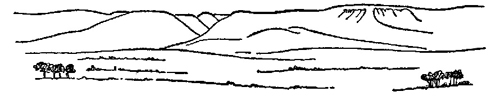
FIG. 3.—Silhouette of the northern face of the Cairngorms—a dissected plateau.
Imagine the processes of erosion and dissection proceeding over many square miles of nearly horizontal strata, until much more has been removed than is left, and it will be possible to understand the origin of the extreme examples of mountain or plateau dissection to be seen in Western Ross and Sutherland. Here, formerly, nearly horizontal layers of Torridonian sandstone covered an ancient surface of hard and resistant crystalline rocks. To-day, such mountains as Suilven and Canisp represent the last remains of these sandstone masses, most of which have long since vanished. In this category also must no doubt be placed Lugnaquilla (3039 ft.) in south-eastern Ireland—the last remnant of rocks overlying a large boss of granite.
There is one other point about the effects of erosion which is worthy of brief mention. If a mountain mass or ridge were composed of uniform materials and if it were equally eroded on all sides, the shape of the mountain would tend to approach more and more closely, as time went on, to that of a perfect cone. This generalised type of mountain is not perhaps very common in Britain—though isolated hills like Muckish and Errigal in Donegal are of this general type as well as many of the rather lumpy mountains in the Scottish Highlands, especially perhaps Schiehallion. The Paps of Jura, illustrated in Pl. 3a, show the disintegration of a quartzite ridge in this way. A common British variant of this simple type is one in which the summit is distinctly flat-topped or tabular. This is particularly to be seen in some of the examples already mentioned. The three most prominent Pennine summits, Cross Fell, Ingleborough (see Pl. 17) and Kinder Scout all have this form as do the Sutherland mountains Suilven and Canisp, and MacLeod’s Tables, west of Dunvegan in Skye. It is due to the presence at the summit level of a horizontal stratum of hard and resistant rock, usually Millstone Grit in the Pennines and Torridonian Sandstone, capped by Cambrian quartzite in Sutherland, the latter containing so much white quartz that the rock may be mistaken for a snow-cap when seen from a distance (see Pl. III).
The Craven Uplands show in a particularly striking manner the dependence of mountain scenery and vegetation on the geological structure. The rocks are horizontally stratified and they consist of an upper zone, mainly of Yoredale sandstones and shales, below which lies a great thickness of Carboniferous Limestone, once called the Mountain Limestone from its association with upland areas in Britain. Where the overlying rocks have been removed by erosion, the hard limestone may form extensive plateaux, and because it is almost pure calcium carbonate, it yields practically no soil on weathering. It is traversed in all directions by deep vertical fissures and is consequently dry (see Pl. XXII). The surface, aptly called “limestone pavement,” is usually devoid of vegetation except where traces of glacial drift occur, but a luxuriant flora lives in the shelter of the fissures. The limestone plateaux are often bounded by almost vertical “scars” (see Pl. XVIII). A very striking type of scenery is thus produced, a feature not only of the Craven Uplands and mid-Pennines in general, but also of large areas in Western Ireland (Clare and Mayo).
In contrast, the Carboniferous Sandstones (including Millstone Grit) and shales are non-calcareous and are almost always covered by the moorland vegetation which is so characteristic a feature of the high plateaux of the northern and southern Pennines. In Craven, where these rocks are exposed along with the limestones, the contrast between the two sorts of rock is often very striking, and is well illustrated in Pl. 4. Thus both the physical and chemical qualities of the rocks may affect the scenery and vegetation.
The simple conical form that is to be expected where rocks of approximately uniform texture are equally eroded on all sides, is lost not only when the harder rock strata occur, but also wherever the mountain is composed of strata that are not horizontal. Thus both Blencathra and Dow Crags in the Lake District show one gently sloping aspect (see Fig. 4) which is that of the “dip” or slope of the rock strata, while on their steep faces the rock weathers into blocks, more or less at right angles to the dip of the strata, so that a
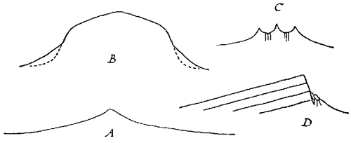
FIG. 4.—Some types of mountain form. A, Symmetrical weathering of uniform rock; B, Recent oversteepening below ancient upper form; C, Ridge with softer interbedded rock; D, Dip and scarp slopes.
steep angle tends to persist. In Wales, Tryfan also shows this type of structure in a still more spectacular manner (see Pl. II) and it is very generally to be seen in the different mountain areas, often recurring, again and again, wherever the rock strata act as guiding planes for the inevitable erosion.
Sometimes hard rocks arranged in this manner overlie much softer ones. Such is the essential structure of Mam Tor, the “Shivering Mountain” in Derbyshire, and also of Alport Castles not far away. In both cases, hard sandstones and grits in the upper part of the escarpment have below them soft shales which are constantly washing and weathering away. Thus, on Mam Tor, the upper parts of the escarpment is constantly being undermined and so are constantly falling. Alport Castles, in contrast, represent an immense wedge of the mountain detaching itself from the face behind and falling outwards with infinite slowness, pushing before it into the valley a great wave of earth, as is well shown in Pl. 6. There are no better examples in Britain of the instability of mountain structures than these two Derbyshire hills.
In other British mountain areas, the comparatively simple arrangements of rocks seen in the examples already discussed are obscured and other considerations become important. An upfold like that met with in the Pennines is called an anticline (see Fig. 1) and a corresponding valley-shaped fold (or depression) would be called a syncline. Now it is a striking fact that the mountain summits very often represent the remains of a syncline. Naturally this is only in areas where great erosion has taken place. The reason for the persistence of the synclinal folds as mountains is that when folding takes place as a result of lateral pressure, the synclinal folds will be compressed and so will tend to become harder. Anticlinal folds, on the other hand, will come under tension and so will tend to crack.
Thus when weathering and erosion takes place, the anticline, being shattered, is more easily attacked and suffers more, while the syncline, being compressed and hardest, therefore tends to be more slowly affected. It is thus logical, if somewhat unexpected, to find that great peaks or perhaps particularly ridges often represent the remains of a syncline, though the synclinal structure may not always be evident because the main ridge of the mountain often represents the long axis of the synclinal fold.
The classical example of synclinal mountain structure, of which a fine picture exists in Lord Avebury’s Scenery of England, is that of Y-Wyddfa, the main peak of Snowdon, as seen from between the Crib Goch and Crib y Ddysgl under suitable conditions—with a powdering of recent snow. This face is usually in shade and not easily photographed to bring out the rock structure, but the essential features are shown in Fig. 5.
Another fine and well-known section illustrating synclinal structure is exposed on the Clogwyn du’r Arddu, to the north-west of the main
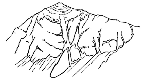
FIG. 5.—Rock structure showing syncline on Y-Wyddfa—the Snowdon summit.
summit, where a great synclinal fold makes up the whole of the precipice. These rather simple illustrations serve to illustrate a very important fact that where great earth-movements have taken place the contortions of the rock strata may greatly affect their hardness and resistance to erosion.
Snowdon itself represents the bottom of a great fold whose crest lay somewhere to the south-east. In that locality some 20,000 ft. of rock must have been removed by erosion. The human mind can hardly appreciate the length of time, not less than hundreds of millions of years, which erosion on this scale must have taken. The rocks now exposed belong to two ancient systems which we have already encountered in discussing an earlier illustration (see Pl. 3b). They are in geological terminology of Ordovician and Silurian age (see Britain’s Structure and Scenery by L. Dudley Stamp). The central core of Wales, as of the Lake District, consists of Ordovician rocks which are solidified volcanic ashes and stones (tuffs) and lava flows, with interbedded marine strata indicating a submarine origin. These make up some of our boldest mountain scenery, though there is nothing to suggest that the individual mountains such as Snowdon, Cader Idris or Scafell have ever been volcanoes. Associated with the Ordovician tuffs and lavas are extensive sedimentary rocks of later Silurian age which are mainly fine grits or shales, and these, though generally softer, are as a rule rather poorer in bases like lime. They form somewhat more rounded hills (sometimes described as moels, their Welsh name), to-day almost always grass-covered like the lower slopes of the Ordovician crags. The general appearance is well shown in Pl. XXIII. Together, the Ordovician and Silurian rocks make up some of the most extensive areas of British upland country, characteristic not only of Wales and the Lake District, but also of the Southern Uplands of Scotland and Southern Ireland.
The mention of volcanic action should not necessarily suggest an identification of parts of a particular mountain with the cone and crater of an extinct volcano. The correct interpretation of signs of volcanic action among British mountains is usually possible only if one keeps clearly in mind the fact that most mountains are likely to be the remnants of larger structures. Usually then it will be vain to look for anything so obvious as the cone and crater of a Vesuvius or a Stromboli. The nearest approach to this sort of structure that we are likely to find in Britain is seen in some of the Laws of Southern Scotland.

FIG. 6.—A Scottish “Law”—eroded remains of ancient volcanic vent. The shaded areas are basalt (lava flows)—the laminated areas are volcanic tuffs (ashes).
These usually represent the vents of small volcanoes which have become plugged with solidified lava whilst the surrounding cone has been more or less completely removed by erosion. A simplified section is given in Fig. 6. One of the most complete examples, Largo Law in Fife, is essentially similar but has two main vents. The figure shows the position of the vents and the lava flows which are marked by “basaltic” rocks. Around these are the remains of the cones formed by tuffs or solidified volcanic ashes and stones. The mineral composition of these volcanic tuffs is characteristic, so that they can be recognised where no volcanic cone is evident. It is this type of identification that is used in the case of the Ordovician tuffs already mentioned, where the scale of output was immeasurably larger and no certain vent can be found.
Igneous rocks apart from volcanic lavas more usually fall into one of two main morphological types. The largest areas are occupied by plutonic rocks, representing enormous masses of molten rock which has solidified without reaching the surface. There are secondly “dykes” and “sills,” both representing intrusions of molten rock among other pre-existing strata. In the case of dykes the intruded material runs through cracks or planes at right angles to the general stratification—in the case of sills the molten rock follows between the bedding planes and therefore runs parallel to the general “dip” of the rock. Sills are often more resistant than the rocks into which they have been intruded, and when this is the case they may form striking cliffs. Especially well-known examples are some of the sills in the Edinburgh district, of which perhaps Salisbury Crags are the most impressive. In Northern England the Whin Sill not only forms natural escarpments on which part of the Roman Wall stands, but it is associated both with a remarkable flora and with a series of majestic cascades in and near Upper Teesdale. Far away on the western side of the Pcnnines, it outcrops again on the great western escarpment, particularly at Roman Fell and in the spectacular amphitheatre of High Cup Nick, where it is eighty feet thick.
Dykes are often on a much smaller scale, but when found among resistant rocks they often give rise to striking gullies and cols. Perhaps the best-known mountain structure of this type is Mickledore, the great gap separating Scafell from Scafell Pike.
The larger intrusions of igneous rock are very often great bosses of granite which may be many miles across. Classical examples are those in Galloway, which give the mountains of Criffel and of Cairnsmore of Fleet. To this type of structure belong the summit of Crib Goch and also Penmaen Mawr in Wales, the latter familiar to every one who drives along the coastal road. Generally similar is the huge granite mass of Dartmoor. In all these cases the granite boss is harder than the surrounding country rock and so has been left more elevated than the areas around. Where the surrounding rocks are hard, however, granite bosses may contribute no noteworthy structure to a mountain region, and this is the case in the Lake District, for example, where the Shap, Eskdale or Ennerdale granites are all relatively inconspicuous among the hard slates into which they were intruded.
Along the western seaboard of Scotland granite intrusions occur among other traces of volcanic or plutonic activity. The Western Isles and many of their mountains include the remains of vast flows of basaltic lavas which formerly stretched from Antrim, through Staffa, Mull and Arran to Skye, and, indeed, as far north as the Faeroe Islands and Iceland. Geologically, these lava beds are of Tertiary Age and very much more recent than the tuffs of the Lake District and Wales. Even to-day the beds lie nearly horizontal, and though they form the well-known columns of Staffa and the Giant’s Causeway and are often exposed in sea-cliffs (those of Eigg and of Portree Harbour, for example), they do not as a whole contribute much to our mountain scenery. Nevertheless, the familiar view of the mountains of Mull, Sgurr Dearg and its neighbours seen from Oban, consists almost wholly of rocks of this type, forced upward by later volcanic action in Central Mull. Still farther north, in Skye, the Storr Rocks (see Pl. IV) and the Quirang are, moreover, both composed of these Tertiary lavas overlying softer Jurassic shales, and the whole of the coastal scenery is dominated by them.
Much more important scenically were the great subsequent upwellings of molten igneous matter in this area, which are associated with the noble mountain scenery of Skye, Rhum and Arran. In Skye, the principal contrast is between the Black Coolin and the Red Hills. The crags of the former are composed mainly of a hard and basic rock called gabbro, with a coarsely crystalline structure that delights the climber’s heart. The Red Hills, in contrast, are granite and this has weathered far more rapidly and uniformly to give mountains of smooth and rounded aspect. The contrast, known to every visitor to Skye, is extremely well shown in the fine photograph (Pl. 1) of Blaven and Ruadh Stac, the former of gabbro and the latter of granite. The gabbro is intersected by igneous “dykes” which, running mainly north-west and south-east, serve to accentuate the differences, for these are more easily eroded than gabbro and so tend to form the gullies in the great gabbro ridges. Pl. VII gives an excellent impression of the distant aspects of the rock and the ridges.
Somewhat similar contrasts are to be seen in Rhum, where the outstanding peaks of Hallival and Askival are composed of ultra-basic and coarsely crystalline rocks of an unusual type. Their craggy outlines contrast noticeably with the grassy and rounded appearance of the hills farther west, such as Fionchre and Bloodstone Hill, both mainly built of more easily weathered basalt. A similar contrast is seen between the peaks of igneous rock and the gentle moorland contours of the Torridonian sandstones in the northern part of the island, which form a foreground as seen from Skye. In northern Arran, too, there were great intrusions of igneous rocks. The granite of Goatfell stands out boldly, as seen from Brodick Bay, against a foreground of softer sandstones.
The igneous geology of these western mountains is extremely complex and cannot adequately be discussed here except where it plays a part in determining the characteristic features of a mountain mass. But a few words may perhaps be spared for Ben Nevis (4406 ft.) which, as the highest mountain in Britain, deserves at least a passing mention. Ben Nevis represents a central plug of rock, surrounded by two cylinders of intrusive granite, that is presumably by two cylindrical faults, filled up from below by molten rock. The cap of the mountain core consists of ancient lavas (Old Red Sandstone Period) overlying Dalradian schists, and it is supposed that this central core of rock must have sunk considerably into the molten rock now represented by the granite cylinders. Going east from Ben Nevis, Carn Mor Dearg lies on the inner cylinder of granite and Aonach Mor (3,999 ft.) on the outer cylinder. From the north-west, both types of granite can be distinguished on the route from Fort William to the summit of Ben Nevis.
A similar complex system centres round Glen Etive, with the Buchailles of Etive representing a cap of rhyolites and tuffs on a core surrounded by cylinders of granite. Ben Cruachan lies wholly on one of the granite intrusions and so too does the greater part of the Moor of Rannoch.
From the point of view of their influence on the animal and plant life, a highly important property of the volcanic and igneous rocks is whether or not they are rich in basic substances like lime, potash and magnesia.
The geological classification expresses these features inversely in terms of the amount of the non-basic material, silica, which is present, as shown in the following table:
Table 1 SILICA CONTENT OF IGNEOUS ROCKS
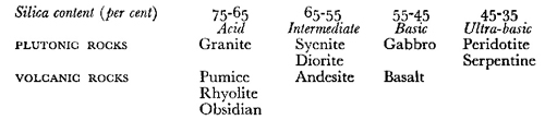
Biologically, the basic and ultra-basic rocks provide habitats which are generally more interesting largely because they yield richer soil. The favourable feature of a high base content is, it is true, often partly counteracted by the hardness of the rocks and an accompanying resistance to weathering and erosion, as in the examples already given from Skye and Rhum. But many British basalts are not only basic but they also weather especially easily to yield a comparatively rich soil. The Ordovician tufls are often intermediate in character and may include much andesitic material. In contrast, most British granites contain on an average over 70 per cent of silica and they yield soils which may consist of little but sand and which, as a result, are correspondingly infertile. The biologist thus soon learns to regard granite areas as a distinctive upland type, just as they are geologically and scenically. On the other hand, he has learnt to approach areas dominated by basic or ultra-basic rocks with a certain amount of optimism. Their more varied vegetation and fauna runs parallel with the higher base-status of the soils and rocks, and the latter, indeed, often contain large amounts of bases such as potash, magnesia and iron oxides instead of the lime that prevails in many sedimentary rocks. By analogy with other parts of the world, it is probable that the presence of certain plants and animals on the basic and ultra-basic rocks is associated with these peculiarities of chemical composition of the latter.
The great variety of rock type and of rock arrangement which runs through the Western Islands is less apparent on the Scottish mainland. There the mountain masses of the Grampians are mainly composed of hard and ancient rocks, so greatly contorted by subsequent earth movement that their arrangement is often obscure and it is consequently less easy to describe in broad general terms their relation to mountain structure. They are geologically, for the most part, schists or gneisses (which are, respectively, metamorphosed and distorted shales or sandstones and grits) or finely crystalline igneous rocks. But the simple principles which have been stressed above are generally applicable when the structure of any individual mountain or upland area is considered. Without considering these in detail, it may be noted that the Grampians include three main areas of differing structural type, which have biological interest. Towards the south and west there is an area in which mica-schists predominate. This is a rock which weathers easily, yielding an open and uniform soil. It is marked by a group of characteristic and somewhat lumpy, grass-covered mountains lying roughly along a curved line between Ben Lawers, Ben Doireann and Ben Alder, which possess a well-recognised biological type.
The chief contrast in the Grampians is, however, between the eastern and western halves of the country. The former, exemplified particularly by the Cairngorms, is mainly a high though deeply dissected plateau, which constitutes the greatest continuous area of high ground in the British Isles. The Cairngorms are evidently in the early stages of a new erosion cycle, and their typical outlines, already discussed in connection with Pl. 5, contrast remarkably with those of Dartmoor, for example, also a granite mass, but one characterised by land-forms indicating far advanced weathering and erosion (see Pl. XXXI).
In the western part of the Highlands, erosion and dissection have proceeded far more effectively, so that more often the mountains are partly isolated peaks or broken ridges. The change has undoubtedly been hastened not only by greater precipitation and glacial erosion in these areas, but also by the presence of numerous faults, running roughly from north-east to south-west, which have offered full play to eroding influences and have given us a series of loch-filled valleys. The most notable of these fault-lines is that of the Great Glen. Nevertheless, in spite of the much greater amount of erosion, the general level of the summits among the western mountains is very uniform and is indicative of that of the original plateau from which they must have been derived.
The Scottish Highlands illustrate very well a point that was emphasised a long time ago by the late Professor J. E. Marr. In general, as upland surfaces recover from disturbances, they will tend to develop systems of gentle slopes and to approach, as Dartmoor is doing, characteristic forms of “subdued relief.” Among the upper levels of our British mountain regions it is possible to see a large proportion of land forms which are predominantly those of subdued relief. This implies that these forms must be of great age, for on account of the great hardness of the rocks, it must have taken an enormous time for the outlines to have “softened” in such an extreme manner. From arguments such as these, it may be assumed that the general form of our mountain regions is often ancient, and this usually applies particularly to the positions of the main summits and the river valleys. Superimposed on these ancient features we have also features which are the result of comparatively recent agencies. Foremost among these are the effects of ice and of glaciation.
