Полная версия
Southern England

FIG 44. Diagram showing the large granite body below the bedrock of Cornwall and Devon, and the way the granite bosses now visible at the surface are upward extensions of this larger body.
Although there was probably some time range in the arrival of different granite bodies in the upper crust, the main episodes took place at the very end of the Carboniferous and during the earliest Permian, roughly 300 million years ago.
The arrival of the granites from below was only one part of the invasion of the upper levels of the bedrock that took place at this time. Widespread mineralisation around the granites has probably been even more important than the arrival of the granites themselves, in terms of human history. The term mineralisation is used to cover the alteration of the solid granite and the surrounding (older) bedrock that has, in some areas, been caused by the movement of very hot and chemically rich water, using the network of cavities and fractures that existed in the rocks. Because of the chemistry of the rocks deep down, many different chemical elements were brought to the upper levels and crystallized there to form new and valuable minerals, or caused alterations of the earlier solid rocks.
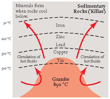
FIG 45. Simple diagram of a slice through the Earth’s upper levels, showing how the temperature patterns around a granite body have been responsible for the distribution of minerals containing the more important chemical elements.
The granites probably solidified in the Earth at temperatures of about 850 °C, and most of the mineralisation happened at rather lower temperatures as the rocks cooled (Fig. 45). Tin, wolfram, arsenic and copper minerals formed at between 500 and 300 °C, whereas silver, lead, zinc, uranium, nickel and cobalt minerals formed at between 300 and 200 °C, and iron minerals between 200 and 50 °C.
The tin of Cornwall was a major reason why some of the early inhabitants of mainland Europe were interested in Britain. In fact there is evidence that tin minerals were being gathered here more than 3,000 years ago, during the Bronze Age. In those days, much of the material was collected from young sands and gravels derived from the weathering and erosion of the mineral-bearing rock, unlike later times when mining techniques were developed to extract tin directly from the bedrock.
Some granite areas contain much more mineralisation than others, and the range of minerals and chemical elements that are present varies greatly. This depends on the temperature of the granite emplacement and the chemistry of the fluids accompanying and following the granite. The Land’s End and Carnmenellis granites are particularly rich in tin, and it is around these granites, in areas near to St Ives, Camborne, Redruth and Helston, that most of the mining has been concentrated. The remains of this mining are often clear to see (Fig. 46), but the presence of the minerals themselves does not generally influence the natural scenery.
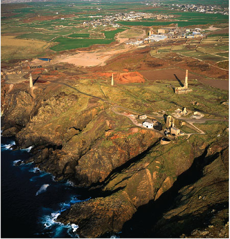
FIG 46. Tin mine workings near Cape Cornwall, west Cornwall. (Copyright Dae Sasitorn & Adrian Warren/www.lastrefuge.co.uk)
In some of the granites, hot fluids from below altered the mineral feldspar (one of the dominant granite minerals) and turned it into the soft clay mineral kaolinite. The china clay industry has developed round the presence of this mineral, which has usually been extracted from the altered granite by washing it out with powerful water jets. This process has changed the scenery dramatically, particularly around the St Austell granite. For every tonne of useable kaolin, 5 tonnes of waste granite material are produced, and heaps of this waste are obvious scenic features in these areas (Fig. 47). The famous Eden Project at Bodelva, near St Austell, has been constructed inside a large former china clay quarry.

FIG 47. China clay excavations at St Austell. (Copyright Dae Sasitorn & Adrian Warren/www.lastrefuge.co.uk)
The older rocks surrounding each of the granite intrusions generally show evidence of alteration that occurred as the mobile granite worked its way upwards from below. This contact metamorphism, often accompanied by the growth of new minerals, is the result of the transfer of heat and introduction of new chemical components from the granite. It has usually resulted in making the rocks more resistant to later erosion at the surface.
Younger episodes
Sedimentary markers
Between 7 and 20 km to the southwest of Exeter, traversed by the A38 and A380 trunk roads, the Great and Little Haldon Hills are capped by a layer of sediments, assigned to the Upper Greensand, and spanning in age the Early/Late Cretaceous boundary (between about 105 and 95 million years ago). These are the westernmost erosional relicts of a continuous sheet of sediment of this age that extended across much of the rest of Southern England. In the Haldon Hills area, the sandy and fossiliferous material seems to have formed near the coastal margin of an extensive Cretaceous sea.
The Haldon Gravels are distinctive deposits that occur above these Cretaceous sediments. They consist largely of flint pebbles and contain sand and mud between the pebbles. Some of the gravels appear to be the result of removal by solution of the calcareous Late Cretaceous Chalk that can no longer be found in its unaltered state so far west. The flint nodules in the Chalk were then left as a layer of much less soluble pebbles. Some of the gravel appears to have been carried to its present position by rivers or the sea, perhaps also with the incorporation of kaolinite clay from the Dartmoor granite. The age of these gravels appears to be early Tertiary, perhaps about 55 million years.
A few kilometres west of the Haldon Hills, northwest of Torquay, the Bovey Formation of early Tertiary age (Eocene and Oligocene, about 45 to 30 million years ago) occurs in a distinct, fault-bounded basin. The formation is more than 1 km in thickness and consists primarily of the clay mineral kaolinite, deposited as mud by local streams, and associated with minor amounts of sand, gravel and peat-like organic deposits of lignite. This sediment fill continues to be a very important material for ceramics, pipes, tiles etc. ranging from high-quality china clay to lower-quality materials. Most of the sediment appears to have been carried into the basin from the area of the Dartmoor granite and its surroundings. The Bovey Basin formed as a result of subsidence along the northwest-to-southeast trending Sticklepath Fault Zone (Fig. 39) which cuts across the whole of the Southwest Region. This fault zone seems to have been active during the accumulation of sediment in the basin and so, at least in this phase of its history, it was much younger than the Variscan structures of the Southwest generally. Further to the northwest along the same fault zone is the smaller Petrockstowe Basin near Great Torrington (see Fig. 38), and, offshore, under the Bristol Channel is the larger Stabley Bank Basin, east of Lundy Island.
About 6 km southeast of St Ives (see Area 1), near the small village of St Erth, a small area is underlain by some soft sands and muds. When first exposed by quarrying, these sediments provided a rich assemblage of fossils that are thought to have lived some 3 million years ago, in latest Tertiary times. The fossils suggest sea depths of between 60 and 100 m, and are now about 30 m above sea level, so they provide a fragment of evidence from a period when the sea was more than 100 m higher than it is now, relative to the land of Cornwall. As will be mentioned below, this deposit is rather similar in its elevation to the most obvious plateau recognised in many of the inland areas, which may also relate to an episode when the sea stood at this level.
Drainage patterns
On the scale of the whole Southwest Region, the main upland areas are Exmoor in the north and the zone of distinct granite domes in the south, extending from Dartmoor to Land’s End.
The highest point of Exmoor is Dunkery Beacon (519 m). Exmoor has been eroded from Devonian bedrock, and may owe some of its elevation to the greater resistance to erosion of this material compared with the Carboniferous material that forms the bedrock further south. Another possible factor is suggested by the remarkable way that many of the river systems of the southwest drain to the south coast, despite their sources being remarkably close to the north coast (Fig. 48). This is the case for the Exe, flowing from Exmoor southwards via Exeter to Exmouth, and, further west, the Tamar, which begins northeast of Bude and flows southwards past Launceston and Tavistock before discharging into Plymouth Sound. It looks as if this part of the Southwest Region has been tilted southwards as these river systems developed on either side of the high ground of Dartmoor, where the granite resisted erosion. A southerly tilt would also be consistent with a preferential uplift of the Exmoor Hills to the north.
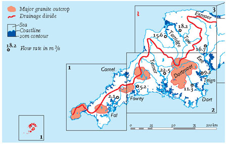
FIG 48. River pathways, mean flow rates (m 3/s) at some river stations, main drainage divide (red line) and main granites of the Southwest Region.
The southern areas of hills correspond so clearly with the areas of granite outcrops that there can be little doubt that the greater resistance to erosion of the granite explains their higher elevations. But how long has this erosion been taking place? Emplacement of the granites was over by the end of Carboniferous times (about 300 million years ago) and there is evidence of pebbles in the New Red Sandstone from the Dartmoor granite and from the altered bedrock close by. Although the precise age of the earliest New Red Sandstone is uncertain, it does not appear to be much younger than the age of granite emplacement. However, it appears that the granites were not being significantly eroded in quantity much before Cretaceous times, 200 million years later and about 100 million years ago. Since then, the granites have been eroded into the present patterns of local hills and valleys, but at very variable rates as climate, coverage by the sea and rates of river erosion changed.
Each of the main granite bodies corresponds closely to an area of high ground, and their maximum heights tend to be greater towards the east (44 m for the Isles of Scilly, 247 m for Land’s End, 252 m for Carnmenellis, 312 m for St Austell, 420 m for Bodmin and 621 m for Dartmoor). This gradient is overall only about 3 m per km. The geophysical data on the large, deep granite body (Fig. 44) recognised below the surface granite bodies do not provide independent evidence for a slope of this sort deep down. Some tilting of the landscape downwards towards the west may have occurred, or the slope may simply reflect the greater proximity of the western granite bodies to the sea and repeated episodes of marine erosion.
Ice Age episodes
Ice sheets do not appear to have covered the present land of the Southwest Region to any important extent during any of the major cold episodes of the Ice Age. In the Isles of Scilly, material deposited directly from a grounded ice sheet has been recognised and is thought to be Devensian (last cold phase) in age (Fig. 49). Various giant boulders derived from metamorphic sources are a notable feature of some localities on the North Devon coast, some of which appear to have come from Scotland. However, it is not clear whether they were transported to their present locations by a large ice sheet or by floating ice.
In spite of the lack of an actual ice sheet, the repeated cold episodes of the Ice Age must have had a considerable effect upon the weathering style of the bedrock, for example influencing the granite tors, mobilising material to move down slopes and changing drainage patterns and the surface blanket of soft materials.
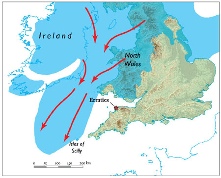
FIG 49. Map showing the greatest extent of the last main (Devensian) ice sheet across England and Wales.
AREA 1: WEST CORNWALL
A remarkable feature of the peninsula of West Cornwall (Figs 50 and 51), as it narrows towards Land’s End, is the contrast between the spectacular coastal scenery and the scenery inland. The rocky coastal cliffs and sharply indented coves reflect West Cornwall’s exposure to the prevailing Atlantic storms, and contrast starkly with the inland scenery of rolling – though often rocky -hillsides, carved into a network of small valleys and streams.
The main features of the inland landscape appear to have formed over millions of years, and ultimately reflect the bedrock pattern that has been inherited from the Variscan mountain building that ended 300 million years ago. In contrast, the coastal landscape is clearly much younger, and much of it has been produced by changes in sea level that have occurred since the last main cold phase of the Ice Age, some 10,000 years ago. There is some evidence of earlier sea levels but this is more difficult to evaluate, as it has generally been removed by more recent erosional events.
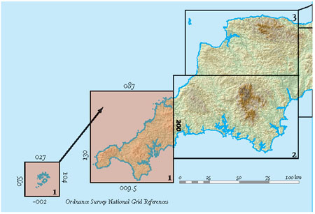
FIG 50. Location map for Area 1.
I have divided West Cornwall into three Landscapes (A to C), each with distinctive bedrock geology (Fig. 52).
Landscape A: Granite areas
The Isles of Scilly (A1; Fig. 53) are formed by the westernmost significant granite bodies of southwestern England. They lie some 45 km southwest of Land’s End, scattered over an area approximately 20 km by 15 km. Most of the 150 islands are little more than bare outcrops of granite, sometimes largely submerged at high tide. The landscape is windswept and mainly treeless, with heathlands where the ground has not been cultivated. Historically the islanders eked out a precarious existence from crofting, until the nineteenth century, when shipbuilding and the growing of flowers became economic. Today most of the cultivated land consists of small fields of flowers edged with evergreen hedges, and horticultural work, along with tourism, has become the mainstay of the economy.
The smaller islands are often arranged in rows, separated by ‘sounds’ (areas of shallow water) that tend to have a northwest-southeast orientation. These sounds must have been valleys before they were drowned by the recent (Flandrian) sea-level rise. Their orientation is similar to that of the valleys and faults of the Land’s End granite, discussed more fully below. Numerous sandy bays and beaches reflect the granite weathering and the transport of the weathered sediment, by storms and tides, to more sheltered parts of the island landscape.
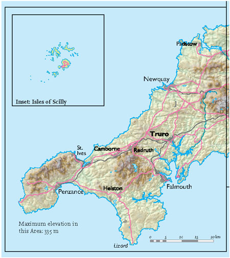
FIG 51. Natural and man-made features of Area 1.
In the general section of this chapter it has been mentioned that the northern Scillies appear to have been invaded by ice late in the history of the last (Devensian) cold phase of the Ice Age (Fig. 49), and this is surprising in view of their southerly location. It appears that when the Devensian ice sheet had grown to its greatest extent, an elongate tongue of ice, perhaps some 150 km wide, extended for nearly 500 km from the Irish and Welsh ice sheets to the edge of the Atlantic continental shelf. This tongue became so large because it was vigorously fed by ice from the high ground of Ireland to the west, and the Lake District of England and the mountains of Wales to the east. The ice extended across the mouth of the Bristol Channel, well clear of the present north Cornwall coastline, before leaving ice-laid sediment on the northern fringe of the Isles of Scilly. South of the island areas that were covered by ice, the granite has been weathered locally into tors.
FIG 52. Area 1, showing Landscapes A to C and specific localities mentioned in the text. Major divisions of Landscape A are identified by A1, A2, A3 etc., and localities are shown as a1, a2, a3 etc.
Land’s End is the westernmost tip of mainland England. The local cliffs are made of granite and clearly show vertical sets of fractures, probably formed when the granite was cooling and contracting (Figs 54 and 55). Apart from the fractures, the granite is massive compared with the strongly layered and deformed rocks into which the main granites were intruded. Most of the northerly inland areas are exposed and windswept moorland, though arable farming for early vegetables has developed in the valleys to the south. The valleys eroded in the Land’s End granite are distinct and often oriented very clearly in a northwest-southeast direction. This orientation is parallel to a large number of faults which appear to have first formed late in the Variscan mountain-building episode. However, they must also have been active much later, after the intrusion of the main granite, because its margin is locally offset by faults with this trend. The movement of superheated water along these fault systems has resulted in mineralisation of the bedrock, altering its resistance to erosion so that valley incision has taken place preferentially in this direction. Tors are largely absent from the Land’s End, Godolphin, Carnmenellis and St Austell granite areas, while they are common weathering features on Bodmin Moor and Dartmoor. This probably reflects a difference in the weathering and uplift histories of the different granite bodies.
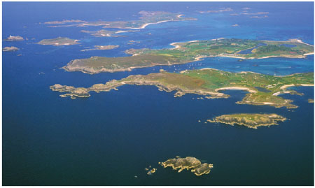
FIG 53. The Isles of Scilly, looking east towards Bryher, Tresco and St Martins. (Copyright Dae Sasitorn & Adrian Warren/www.lastrefuge.co.uk)
The Land’s End granite (A2) forms the bedrock of most of the far southwestern peninsula, which is largely ringed by cliffs. To the east of the granite, St Ives Bay on the north coast and Mount’s Bay on the south coast show how much more readily eroded the Devonian killas is in comparison. Along the north coast of the Land’s End peninsula, the killas is preserved as a screen of land, rarely more than a kilometre in width, but clearly showing distinctive layering, as seen at Gurnard’s Head (a3; Fig. 56). Present coastal erosion may have been slowed at this point by the greater strength of the Devonian where it has been altered close to the granite. Just north of Land’s End point, Whitesands Bay (a1) is one of the only sandy bays to face the open sea to the west. The bay lacks any significant stream system that could have supplied sand to the beach, so it seems most likely that the sand has been carried into this bay by the storms which so often attack this exposed coast.
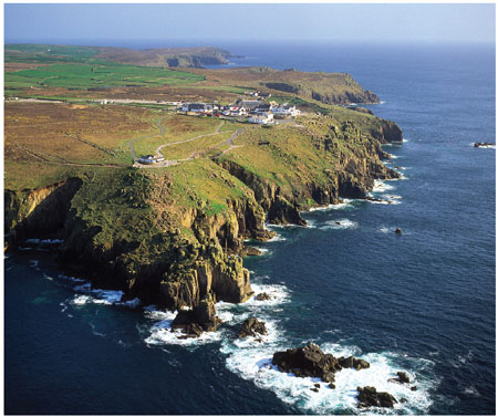
FIG 54. Land’s End peninsula from the air, looking eastwards. Note the lack of clear layering in the granite bedrock and the steep fracture surfaces (joints) that have controlled the form of the cliffs. (Copyright Dae Sasitorn & Adrian Warren / www.lastrefuge.co.uk)
A distinct, though irregular, platform at 100–150 m above sea level rings the area of the Land’s End granite, and tends to be followed by local roads. This may have been formed during an early episode of coastal erosion, when sea level was standing at this height relative to the land (Fig. 57). Some evidence for its age is mentioned below. Its irregularity probably reflects local valley erosion that has taken place since its formation.
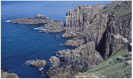
FIG 55. Land’s End cliffs, looking westwards. Again, note the vertical jointing. (Copyright Landform Slides – Ken Gardner)
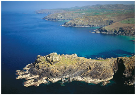
FIG 56. Gurnard’s Head (Fig. 52, a3), west of St Ives, showing the coastline along the northern edge of the Land’s End granite. (Copyright Dae Sasitorn & Adrian Warren/www.lastrefuge.co.uk)
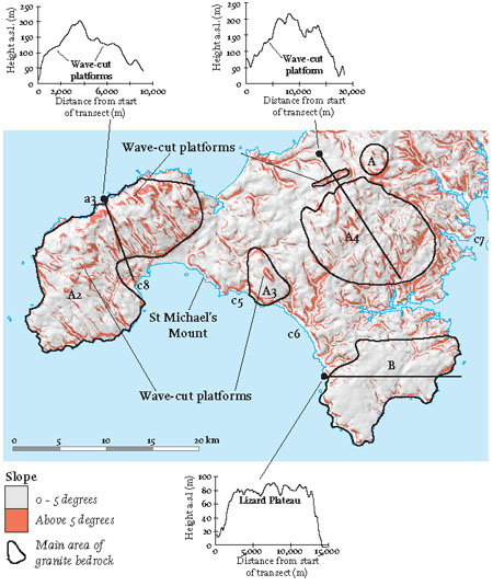
FIG 57. Slope map showing the southwestern part of Area 1. Slopes greater than 5 degrees are coloured red, and the main granite areas and the Lizard Complex are outlined. Topographic cross-sections illustrate wave-cut platforms that are presently inland and show the lack of topography on the Lizard Plateau.
The next main granite bedrock area to the east underlies the Carnmenellis area (A4), although there are other smaller granite areas, such as St Michael’s Mount (Fig. 58), across the bay from Penzance, and the intermediate-sized Godolphin granite (A3), some 8 km to the east. These smaller granite areas show the range in size of ‘feeders’ that branched off from the major granite body that underlies the whole Southwest Region (Fig. 44). In all cases the granite bedrock corresponds to high ground in the landscape – evidence of the greater resistance of the granite in the face of repeated landscape erosion. Derelict mine engine houses litter the landscape, especially northwards near Camborne and Redruth, once prosperous tin-mining centres. To the south, the landscape is more sheltered and fertile, allowing better farming. Trees are rare because of their past cutting for fuel for the mining industry, as well as because of the general exposure of the landscape to the weather.
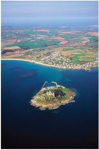
FIG 58. St Michael’s Mount. (Copyright Dae Sasitorn & Adrian Warren/ www.lastrefuge.co.uk)
The same northwest-to-southeast valley pattern that has just been mentioned in the Land’s End granite is also apparent in the area around the Carnmenellis granite, and appears to be the result of preferential stream erosion parallel to the faults trending in this direction (Fig. 59).
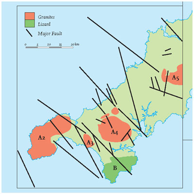
FIG 59. Sketch map showing the orientation of some of the main faults in West Cornwall.
Another similarity to Land’s End is the widespread topographic platform at about 140 m above sea level. This platform is particularly clear north of the Carnmenellis granite but is also obvious in the Godolphin granite (Fig. 57). In the Porthmeor and Camborne areas the platform is particularly distinctive, and the continuity of its landward slope is clear on the slope map. It has generally been assumed that these platforms were cut by storm waves when the sea stood at this level about 3 million years ago. At this time, West Cornwall would have consisted of granite islands, like the present Isles of Scilly, while the surrounding Devonian bedrock (killas) was submerged.