

 полная версия
Narrative of the surveying voyages of His Majesty's ships Adventure and Beagle, between the years 1826 and 1836
After this to new moon the weather was very unsettled, the wind veering between South and W.S.W.; the barometer rising as it veered to the former, and falling as it became more westerly; but on no occasion did it precede the change.
The mean height of the barometer is about 29.5.
The mercury stands lowest with N.W. winds, and highest with S.E.
With the wind at N.W. or northerly the mercury is low; if it falls to 29 inches or 28.80, a S.W. gale may be expected, but it will not commence until the column has ceased to descend. It frequently, however, falls without being followed by this change. In the month of June, at Port Famine, the barometer fell to 28.17, and afterwards gradually rose to 30.5, which was followed by cold weather, in which the thermometer stood at 12°.
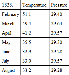
The following Table shews the mean temperature and pressure as registered at the Observatory at Port Famine in the Strait.
The difficulties that present themselves to Navigators in passing round Cape Horn, as well from adverse winds as the severe gales and heavy sea to which they are exposed, are so great, that the Strait of Magalhaens has naturally been looked to as a route by which they may be avoided. Hitherto no chart has existed in which much confidence could be placed; but by the present survey, the navigation through it, independent of wind and weather, has been rendered much easier; since a correct delineation of its shores, and plans of the anchorages, have been made; and in the preceding pages, sufficient descriptions of them have been given to assure the navigator of his place, and furnish him with advice as to his proceedings. The local difficulties therefore have been removed; but there remain much more serious ones, which I should not recommend a large, or even any but a very active and fast-sailing square-rigged vessel to encounter, unless detention be not an object of importance.
For a square-rigged vessel bound through the Strait, the following directions will be useful: —
In the eastern entrance the winds will frequently favour a ship's arrival off the First Narrow; where, if she selects a good anchorage on the bank which bounds the northern side of the channel, she may await an opportunity of passing through the First Narrow and of reaching Gregory Bay; where also a delay may safely be made for the purpose of passing the Second Narrow and arriving at the neighbourhood of Cape Negro; at which place the difficulties and dangers of the eastern entrance cease.
The dangers being carefully placed on the chart, and now sufficiently described, nothing need be repeated here; and indeed much must be left to the judgment and discretion of the navigator.
The tides answer best for vessels entering the Strait at the period of full and change of the moon, since there are two westerly tides in the day. In the winter season, if the morning tide be not sufficient to carry a vessel through the First Narrow, she may return to Possession Bay, select an anchorage, and be secured again before night; or, in the summer, if she has passed the Narrow, and has been enabled to anchor for the tide, there will be sufficient daylight for her to proceed with the following tide to Gregory Bay, or at least to a safe anchorage off the peaked hillocks on the north shore.
I have twice attempted to pass the First Narrow, and been obliged to return to the anchorage in Possession Bay; and twice I have passed through it against a strong breeze blowing directly through, by aid of the tide; which runs, in the narrower parts, at the rate of ten or twelve miles an hour. When the tide and wind are opposed to each other, the sea is very deep and heavy, and breaks high over the decks; it is therefore advisable to close reef, or lower the topsails on the cap, and drift through; for the tide, if at the springs, will generally be sufficient to carry a ship to an anchorage, although, not always to one where it would be safe to pass the night. On this account, it would be prudent to return; for, although the holding ground is exceedingly good, yet, to part in the night, or drift towards, or through the Narrow, could scarcely happen without accident.
In leaving the anchorage in Gregory Bay, attention must be paid to the tide, which continues to run to the eastward in the Second Narrow, three hours after it has commenced setting to the S.W. at the anchorage.
With a leading wind through the Second Narrow, a ship will easily reach an anchorage off Laredo Bay, but, if the tide fails upon emerging from it, she should seek for a berth in the bay to the north of Elizabeth Island, as near to the island as possible, but to the westward of its N.E. end, to be out of the influence of the tide. The depth of water, however, will be the best guide.
Directions for passing round the south side of Elizabeth Island are given elsewhere; and as this part offers some dangers, the chart and the description should be carefully referred to.
The only advice that seems wanting, to improve the directions for the coast from this to Port Famine, is, with a south-westerly wind, to keep close to the weather shore, in order to benefit by the flaws down the valleys; but this must be done with caution, in consequence of the squalls off the high land, the violence of which cannot be well imagined by a person unaccustomed to them.
Of the anchorages between Port Famine and Cape Froward, the only convenient one for a ship is St. Nicholas Bay, to which, if defeated in passing round the Cape, she had better return; for it is easy to reach as well as to leave, and extremely convenient for stopping at, to await an opportunity of proceeding.
From Cape Froward to the westward, unless favoured by a fair wind, it is necessary to persevere and take advantage of every opportunity of advancing step by step. There are several anchorages that a ship may take up, such as Snug Bay, off Woods Bay, near Cape Coventry, in Fortescue Bay, Elizabeth Bay, and York Roads. To the westward, in Crooked Reach, the anchorages are not so good, and excepting Borja Bay, none seem to offer much convenience. Borja Bay, however, is well calculated to supply the deficiency, although for a square-rigged vessel there must be some difficulty in reaching it.
Long Reach is both long and narrow, and ill supplied with anchorages for a ship; such as they are, Swallow Harbour, Playa Parda, Marian Cove, and Half Port Bay, seem to be the best. In thick weather, although the channel is very narrow, yet one side is scarcely visible from the other, and the only advantage it has over other parts of the strait is the smoothness of the water. In Sea Reach there is a heavy rolling swell, with a short and deep sea, which renders it very difficult to beat to windward.
Tamar Harbour, Valentine Harbour, Tuesday Cove, and the Harbour of Mercy, are the best anchorages; and the latter is particularly convenient to occupy, while awaiting an opportunity of sailing out of the strait.
In the entrance, the sea runs very heavy and irregularly during and after a gale; so that a ship should not leave her anchorage in the Harbour of Mercy, without a fair or a leading wind to get her quickly through it.
For small vessels, particularly if they be fore-and-aft rigged, many, if not all of the local difficulties vanish; and inlets which a ship dare not or cannot approach, may be entered with safety, and anchorage easily obtained by them. A large ship will perhaps be better off in entering and leaving the Strait where there is open space and frequently a heavy sea; but for the navigation of the Strait, a small vessel has considerably the advantage. She has also the opportunity of passing through the Cockburn Channel should the wind be north-westerly, which will very much reduce the length of the passage into the Pacific.
One very great advantage to be derived from the passage through the Strait is, the opportunity of obtaining as much wood and water as can be required, without the least difficulty; and another benefit is, that by hauling the seine during the summer months, from January to May, at the mouth of the river or along the beaches in Port Famine, at the first quarter flood, a plentiful supply of fish may be obtained. Excellent fish are also caught at the anchorage with the hook and line, at all seasons, early in the morning or late in the evening. Fish may also be obtained with the seine at any other place where there are rivers. Freshwater Bay and Port Gallant are equally productive. On the outer coast of Tierra del Fuego an excellent fish may be caught in the kelp.
The advantage which a ship will derive from passing through the Strait, from the Pacific to the Atlantic is very great; and it ought to be great to induce the seaman to entangle his ship with the land when fair winds and an open sea are before him. After passing through the Strait, the prevailing winds being westerly, and more frequently from the northward than from the southward of west, they are fair for his running up the coast; or if not, the ship is not liable to receive much injury from the sea, which is comparatively smooth; whereas, to a ship passing round the Horn, if the wind be north-west she must go to the eastward of the Falkland Islands, and be exposed to strong gales and a heavy beam sea, and hug the wind to make her northing. To a small vessel the advantage is incalculable; for, besides filling her hold with wood and water, she is enabled to escape the severe weather that so constantly reigns in the higher latitudes of the South Atlantic Ocean.
Coming from the northward, it will be advisable to keep an offing until the western entrance of the Strait is well under the lee, to avoid being thrown upon the coast to the northward of Cape Victory, which is rugged and inhospitable, and, forming as it were a breakwater to the deep rolling swell of the ocean, is for some miles off fringed by a cross hollow sea almost amounting to breakers.
The land of Cape Victory is high and rugged, and much broken; and if the weather be not very thick, will be seen long before the Evangelists, which are not visible above the horizon, from a ship's deck, for more than four or five leagues.236 Pass to the southward of them, and steer for Cape Pillar, which makes like a high island. In calm weather do not pass too near to the cape, for the current sometimes sets out, and round the cape to the southward; but with a strong wind, get under the lee of it as soon as you please, and steer along the shore. In the night it will be advisable to keep close to the land of the south shore; and if a patent log be used, which no ship should be without, your distance will be correctly known. The course along-shore, by compass, is E. ¾ S.; and if the weather be hazy, by keeping sight of the south shore, there will be no difficulty in proceeding with safety.
The Adventure entered the Strait on the 1st of April, 1830, at sunset; and after passing within half a mile of the islets off the Harbour of Mercy, steered E. ¾ S. magnetic, under close-reefed topsails, braced by, the weather being so squally and thick that the land was frequently concealed from us; but being occasionally seen, the water being quite smooth, and the course steadily steered, with the patent log to mark the distance run, we proceeded without the least anxiety, although the night was dark, and the squalls of wind and rain frequent and violent. When abreast of Cape Tamar, that projection was clearly distinguished, as was also the land of Cape Providence, which served to check the distance shewn by the patent log; but both giving the same results, proved that we had not been subjected to any current; whereas the account by the ship's log was very much in error, in consequence of the violence of the squalls and the long intervals of light winds, which rendered it impossible to keep a correct account of the distance. At daybreak we were between Cape Monday and the Gulf of Xaultegua; and at eight o'clock we were abreast of Playa Parda, in which, after a calm day, the ship was anchored.
In the summer season there is no occasion to anchor any where, unless the weather be very tempestuous, for the nights are short, and hardly dark enough to require it, unless as a precautionary measure, or for the purpose of procuring wood and water; the best place for which is Port Famine, where the beaches are strewed with abundance of logs of well-seasoned wood, which is very superior to the green wood that must otherwise be used.
Notwithstanding that the Adventure experienced no current in the western part of the Strait, there is generally a set to the eastward, which is more or less felt according to circumstances. The direction and strength of the currents are caused by the duration of the gales.
The chart will be a sufficient guide for vessels bound through from the westward as far as Laredo Bay; after which a few directions will be necessary. The land here should be kept close on board, to avoid the Reef off the south-west end of Santa Magdalena. Being abreast of it, bear away, keeping the N.E. extremity of Elizabeth Island on the starboard bow, until you see Santa Marta in one with, or a little to the southward of, the south trend of the Second Narrow (Cape St. Vincent), which is a leading mark for the fair channel until you pass the spit of shoal soundings, which extends across to Santa Magdalena. There are also shoal soundings towards the south-west end of Elizabeth Island; at half a mile off we had five fathoms, – Cape St. Vincent being then the breadth of Santa Marta open to the northward of that island. Keeping the cape just in sight to the northward of Santa Marta, steer on and pass round the low N.E. extremity of Elizabeth Island, off which are several tide eddies. The tide here sets across the channel.
Now steer for the Second Narrow, keeping Cape Gregory, which will be just discernible as the low projecting extreme of the north side of the Second Narrow, on the starboard bow, until you are three miles past Santa Marta; the course may then be directed for the cape, opening it gradually on the larboard bow as you approach it, to avoid the shoal that extends off it.
If you anchor in Gregory Bay, which is advisable, in order to have the whole of the tide for running through the First Narrow, haul up and keep at a mile and a half from the shore. When the north extremity of the sandy land of the Cape is in a line with the west extreme of the high table-land, you will be near the anchorage; then shorten sail, and when the green slope begins to open, you will have fourteen fathoms: you may then anchor or keep away to the N.E., and choose a convenient depth, taking care not to approach the shore, so as to bring Cape Gregory to the southward of S. by W. ¼ W. (by compass). The best berth is with the Cape bearing S.S.W.
Hence to the First Narrow, the course by compass is due N.E. by E.237 The land at the entrance being low, will not at first be perceived; but, steering on, you will first see some hummocky land, making like islands. These are hills on the eastern, or Fuegian side of the Narrow. Soon afterwards, a flat, low sand-hill will be seen to the northward, and this is at the S.W. extremity of Point Barranca. On approaching the narrow, at four miles off, keep a cliffy head, four or five miles within the east side of the narrow, open of the trend of Point Barranca, by which you will avoid the shoal that extends off the latter point. You should not go into less depth than six fathoms. At most times of the tide there are long lines and patches of strong ripplings, through which you must pass. The shoal is easily distinguished by the kelp.
When the channel through the narrow bears by compass N. by E. ¾ E., steer through it; and that, or a N.N.E. course, will carry you through. On each side, the bank extends off for some distance; but by keeping in mid-channel, there is no danger until the cliffy coast be past, when reefs extend off either shore for some distance, particularly off Cape Orange. The N.N.E. course must be kept until the peak of Cape Orange bears south, and the northern Direction Hill W.S.W., or W. by S. ½ S. by compass. Then steer E.N.E. for Cape Possession, taking care not to approach too near to the bank off Cape Orange, or to that on the north side of Possession Bay, for which the chart must be consulted.
For a small vessel, the passage through the strait, from west to east, is not only easy, but strongly to be recommended as the best and safest route. Indeed, I think the passage would be quite as expeditious, and perhaps much safer, to enter the Gulf of Trinidad, and pass down the Concepçion Strait, the Sarmiento or St. Estevan Channels, and Smyth Channel, and enter the Strait at Cape Tamar. In these channels northerly winds prevail, and there is no want of convenient and well-sheltered anchorages for the night, many of which have already been mentioned, and multitudes of others, perhaps much better ones, might be found.
APPENDIX
—TABLES of LATITUDE and LONGITUDE, VARIATION of the COMPASS, TIDE, and HEIGHT.
MAGNETIC OBSERVATIONS, discussed by Major Sabine, R.A., F.R.S.
ZOOLOGY; including Mammalia – Birds – and Shells.
COPIES of ORDERS.
EXTRACTS from a Paper published in the Journal of the Royal Geographical Society.
EXTRACT from a Game-book.
INDEX.
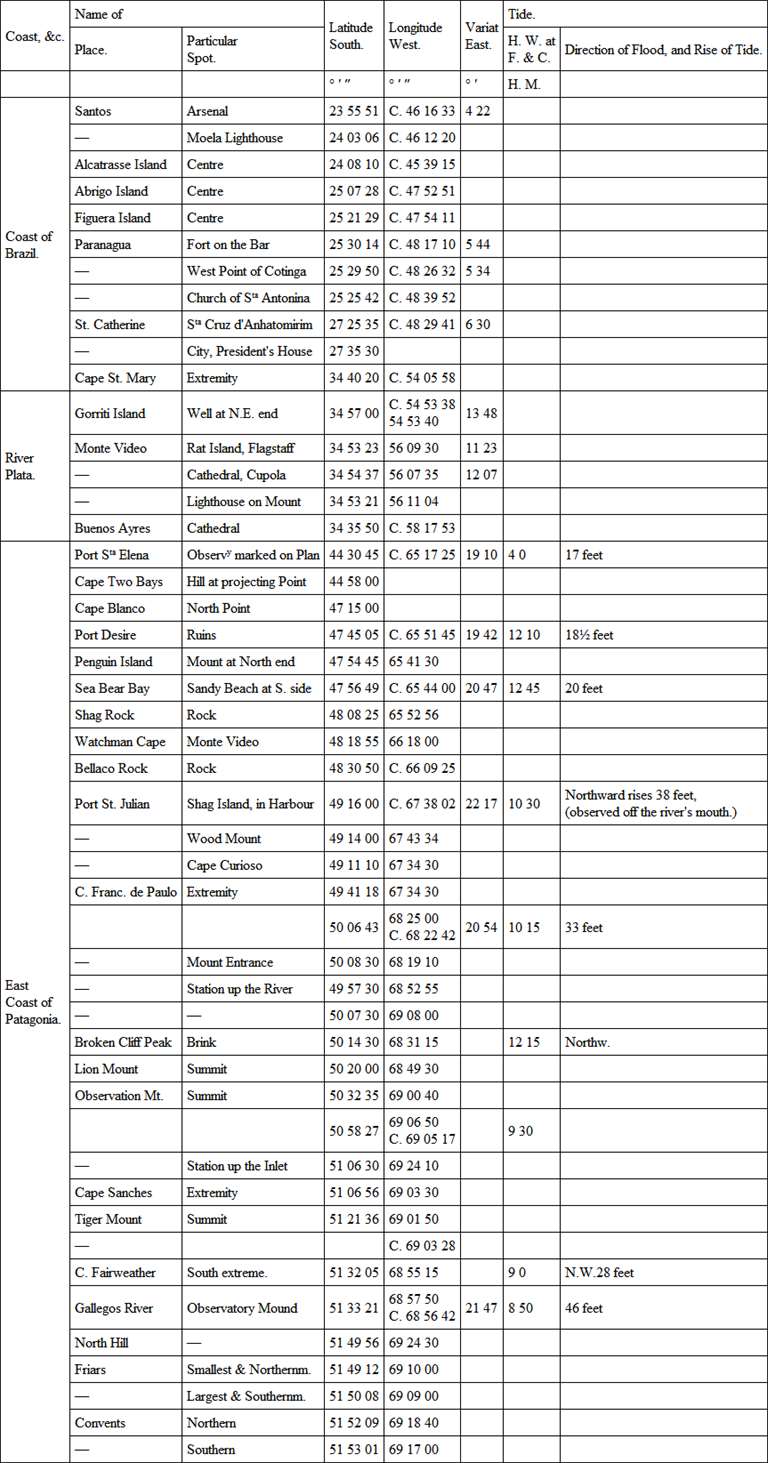
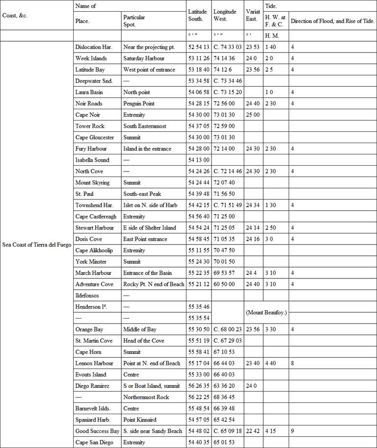
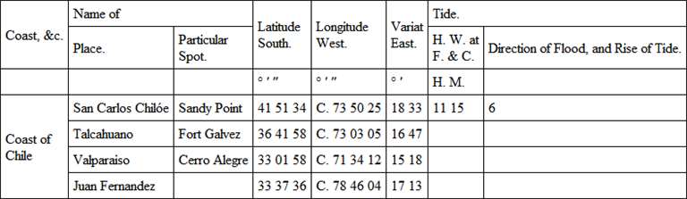
TABLESOFLATITUDE AND LONGITUDE, VARIATION OF THE COMPASS, AND TIDE—ICOASTS OF BRAZIL, RIVER PLATA, AND EASTERN PATAGONIA—The Latitudes to which the character is prefixed, have resulted from Astronomical Observation. The Longitudes which have been determined by Chronometers, are designated by C.; and those by Lunar Distances by. Those without distinguishing marks are the result of Triangulation.
The Longitudes in the following Tables depend upon that of Villegagnon Island at Rio de Janeiro, which was found by fourteen Chronometers from Plymouth to be 43° 05′ 03″ West of Greenwich.
Примечание 1238
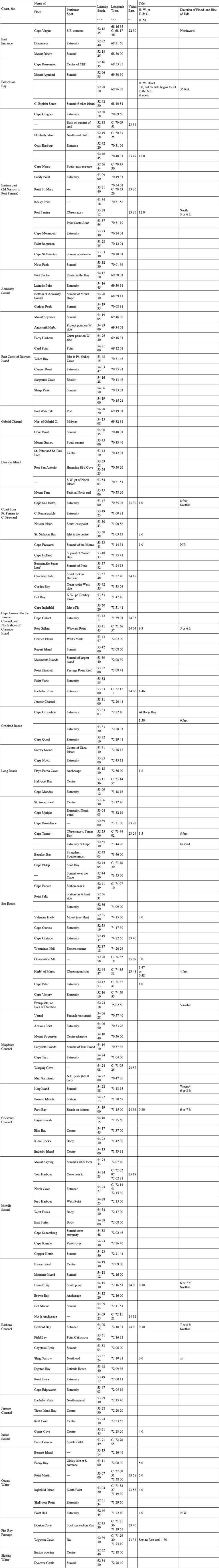
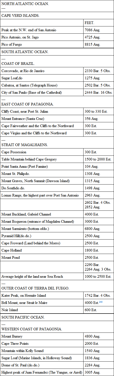
TABLE III—THE WESTERN COAST, AND INTERIOR SOUNDS,FROMTHE STRAIT OF MAGALHAENS TO THE NORTH EXTREMITY OF THE GULF OF PEÑAS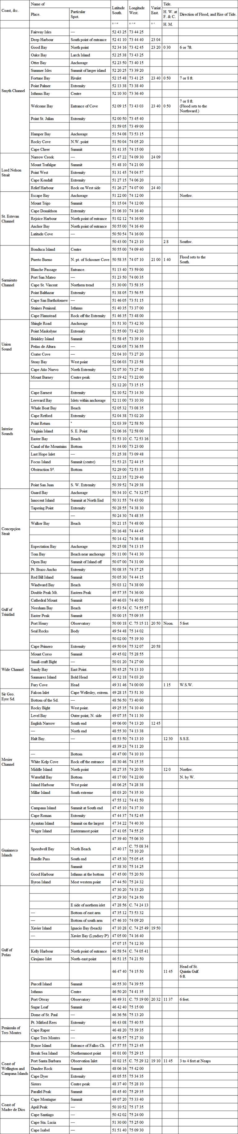
In order to adapt the longitudes of the places mentioned in this Table to the meridians of Port Famine and St. Martin Cove, at Cape Horn, the following corrections239 have been made to Captain Fitz-Roy's chronometrical results, viz: —
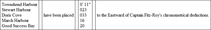
By Captain Fitz-Roy's observations St. Martin Cove would be in long. 67° 31′ 18″, which is 2′ 15″ to the Westward of the mean of upwards of thirty chronometrical results from Monte Video. The difference has, therefore, been equally divided between North Cove and St. Martin Cove; the longitude of the latter being taken at 67° 29′ 03″, and of Port Famine at 70° 54′.
Ang. denotes the height to have been ascertained by Angular Measurement; Bar. by Barometer; and Est. by Estimation.
Примечание 1240
MAGNETIC OBSERVATIONS,DISCUSSED BYMAJOR SABINE, R.A., F.R.S1. Observations of the DipCaptain Fitz-Roy was furnished with two Dip Circles, one by Gambey, and the other by Dollond; the latter supplied by Government, and Gambey's purchased by himself.
Gambey's, being found to give results more accordant with each other than Dollond's, was used at all the stations, except Rio de Janeiro. The Circle was nine and a-half inches in diameter, and was furnished with two needles. This instrument was, in all respects, a very superior one. It was placed for observation on a stand, which raised it from two to three feet above the ground. The needle was observed in eight positions, and as the readings accorded sufficiently well with each other, their arithmetical mean has been taken as the dip resulting from the observation. The eight positions were as follows: 1, with the graduated face of the circle towards the east; 2, with the same towards the west. The needle was then taken out and replaced with the ends of the axle changed, so that each end rested on a different plane to what it did before; it was then observed, 3, with the face of the circle towards the west, and 4, with the same to the east. The poles were then inverted, so that the end of the needle which was before a north pole became a south pole, and the four positions were again repeated. The arc indicated by both ends of the needle was read in every position: an observation of the dip consisted, consequently, of sixteen readings. In the subjoined tabular record these are comprised in four entries, a mean being taken of the arc read at the two extremities of the needle, and of the positions 1 and 3, 2 and 4: 1 and 3 form the column, a; 2 and 4 the column, a′; and the same positions, with the poles reversed, the columns a″ and a″′.
Magnetic Dip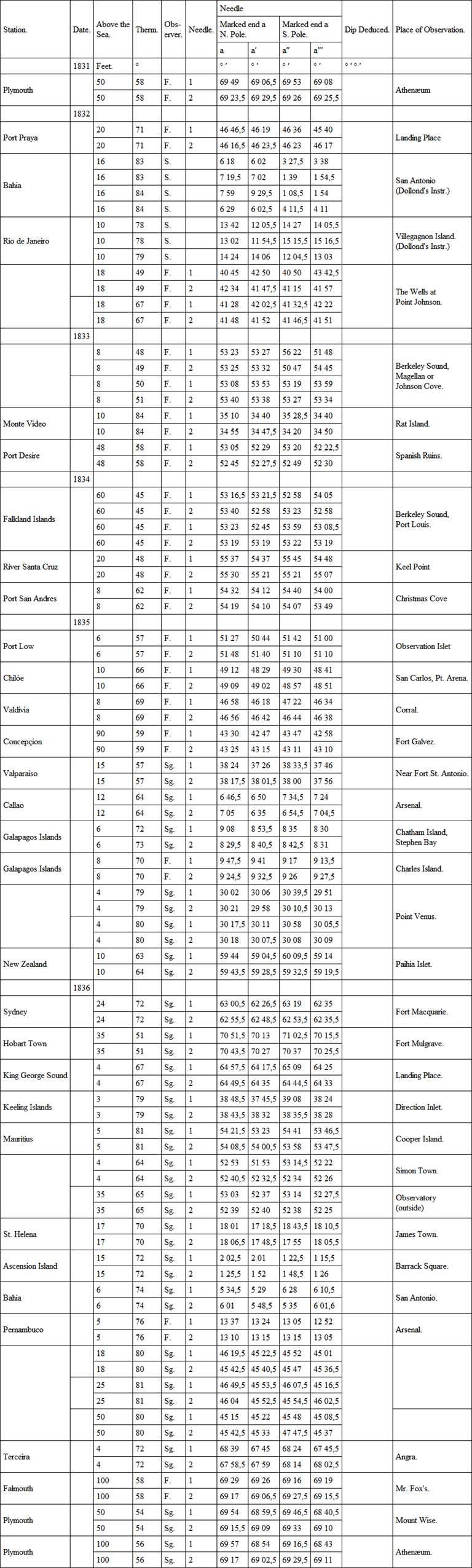
Observers: – F. Capt. Fitz-Roy.S. Lieut. Sulivan.Sg. Mr. Stebbing
2. Observations of Intensity
The method employed by Captain Fitz-Roy to determine the variations of the magnetic force was that of noting the time of vibration of a magnetic cylinder suspended horizontally.
The cylinder was one which had been given by M. Hansteen, in 1826, to Captain Phillip Parker King, R.N., and had been used by him during the survey of the coast of South America, which he conducted from 1826 to 1830. The apparatus in which it was vibrated, both in Captain King's and Captain Fitz-Roy's voyages, was the well-known one of M. Hansteen.
By observations made with this cylinder on the 22d March 1826, and again on the 24th January 1830, in the garden of the Royal Observatory at Greenwich, it appeared that its time of performing 300 vibrations had increased from 734,45 seconds in 1826, to 775,80 seconds in 1831; or 41,35 seconds in 1,770 days. A change of such magnitude in the magnetic intensity of the instrument employed to measure the variations of the terrestrial intensity, and which ought itself, therefore, to be invariable, would, in the generality of cases, have prevented any satisfactory conclusion whatsoever being drawn from the observations. Fortunately from the nature of the duties in which Captain King was engaged, he had occasion to return frequently to the same anchorages, and by his extreme care to repeat observations on every such return, he has provided a means of computing the decrease of the intensity of the cylinder, proportioned to intervals of time, between 1826 and 1831; and of thus introducing compensations for it, which render the results on the whole nearly as satisfactory as if the cylinder had preserved an uniform magnetic condition throughout.
The voyage which Captain Fitz-Roy had to perform promised to furnish few, if any, such opportunities of examining the state of the magnetism of the cylinder, between the departure from and the return to England; and, – as it cannot but be extremely discouraging to officers to make observations which they have reason to apprehend may prove unavailing from defect in the instrument employed, – it must be regarded as exceedingly creditable to Captain Fitz-Roy and his officers, that, with the knowledge of the change which the cylinder had undergone in the preceding voyage, they persevered in diligently observing, and carefully recording, its time of vibration, at most of the principal ports which they visited in their voyage of five years' duration. Nor was it until their return to the Cape Verd Islands, in September 1836, that they could infer, from observations repeated at the same spot as in their outward passage in 1832, that the cylinder had not varied in any thing like the degree that it had done in the preceding voyage, and that the care and pains they had bestowed were therefore likely to be recompensed by success.