

 полная версия
Fifty Years In The Northwest
The legislature of 1869 transferred 44,246 acres, or one-half of the Kandiyohi lands, to the St. Paul, Stillwater & Taylor's Falls railroad.
THE ST. PAUL, STILLWATER & TAYLOR'S FALLS RAILROAD
Part of the lands originally granted to the Stillwater, White Bear & St. Paul railroad were transferred by the legislature of 1869 to the St. Paul, Stillwater & Taylor's Falls railroad. The proceeds of the sale were to be applied to the construction of the above named road. The company was organized under the general laws of the State and incorporated Sept. 23, 1869. The route of the road defined in the articles of incorporation is between St. Paul and Taylor's Falls by way of Stillwater, passing through or near Marine, with a branch road to Hudson, Wisconsin. Length of main line from St. Paul to Stillwater is seventeen and fifty-four one hundredths miles. Hudson branch line from Stillwater junction to Lake St. Croix, three and one-fourth. South Stillwater branch line from Stillwater to South Stillwater, three miles. The first train by this line reached Stillwater from St. Paul Feb. 9, 1872. The capital stock, $1,000,000, may be increased at pleasure. The number of shares of capital stock is 10,000 of $100 each, limit of indebtedness, $1,500,000.
That part of the road to be built from Stillwater to Taylor's Falls up to the present date has not been completed.
THE WISCONSIN CENTRAL (BRANCH) RAILROAD
In 1884 the Wisconsin Central built a branch road from Chippewa Falls via New Richmond to St. Paul, passing into Ramsey county east and south of White Bear. The bridge over the St. Croix river about four miles above Stillwater, belonging to this road, is a fine piece of workmanship, built entirely of iron and resting on solid stone piers. The total length of the structure is 2,400 feet, there being ten spans, each 160 feet long, and a viaduct, 800 feet long, on the Wisconsin side.
The track is 87 feet above low water mark. The entire cost of the bridge was about $197,000. It was damaged by a cyclone in 1885 to the amount of $10,000.
TAYLOR'S FALLS & LAKE SUPERIOR RAILROAD
The franchises and swamp land grant of the Lake Superior & Mississippi railroad pertaining to the Taylor's Falls branch were in 1875, by legislative enactment, transferred to the Taylor's Falls & Lake Superior Company. In 1879 these franchises and lands were transferred to the Minneapolis & St. Louis Railroad Company. In the fall of 1879 the St. Paul & Duluth Company built a branch road to Centre City. In the spring of 1880 the Minneapolis & St. Louis Company built three miles of road southward from Taylor's Falls, accomplishing in that distance as difficult and expensive work of its kind as had been done in the State, the grading being made through the trap rock ledges of the Dalles, and along the face of the nearly perpendicular bluffs overlooking the river. In the summer of 1880 they transferred their franchises and one-half their swamp land grant to the St. Paul & Duluth Company, by whom the road was completed from Centre City to the road already built at Taylor's Falls, Oct. 29, 1880.
CHICAGO, MILWAUKEE & ST. PAUL RAILROAD – RIVER DIVISION
The river division of this road follows the west bank of the river from Dubuque to Hastings, passing through all the river towns. Crossing the river at Hastings it passes through the towns of Newport, Cottage Grove and Denmark, and the cities of St. Paul and Minneapolis, terminal stations. The line from St. Paul to Hastings was built in 1869, by the Chicago & St. Paul Railway Company, under charter granted to the Minnesota & Pacific Railroad Company in 1857. The present management obtained control of the line in 1872. The bridge across the Mississippi at Hastings was constructed in 1878, and was the first iron railroad bridge in the State. In respect to cost and workmanship it ranked with the important structures of the Northwest. The total length of the river bridge is 706 feet, and consists of an iron draw span 300 feet long, two fixed spans each of 150 feet in length, and a combination span on the north shore 106 feet in length. The cost of the structure was $200,000. In 1884 a branch line was extended from Point Douglas to Stillwater.
MINNEAPOLIS, SAULT STE. MARIE & ATLANTIC
The following memorial, introduced by the writer while a member of the state senate of 1877, is the first public mention or suggestion of this road as far as we are aware. It was adopted by the legislature, forwarded to Washington, read and duly referred to the committee on railroads:
STATE OF MINNESOTA.
NINETEENTH SESSION. S.F. NO. 36.
A MEMORIAL
Introduced by Mr. Folsom, Jan. 12, 1877.
TO CONGRESS FOR RIGHT OF WAY AND GRANT OF LAND FOR RAILROAD PURPOSES.
To the Senate and House of Representatives of the United States in Congress assembled:Your memorialists, the legislature of the state of Minnesota, respectfully represent that the rapidly increasing settlements of the Northwest, the surplus agricultural products and material developments demand greater and cheaper facilities than now existing, and a more direct transit to the Atlantic seaboard and European ports, and eastern products transported to the Northwest.
That the saving in the distance to eastern markets of three hundred miles, by a railroad route from St. Paul and Minneapolis to Sault Ste. Marie, will tend to more fully develop the great wheat growing region of Wisconsin, Minnesota, Dakota, and Montana. The surplus of wheat, which forms one of the most reliable exports from our government, in shortening the distance to European markets three hundred miles will give encouragement to this great source of wealth to our whole land, and deserves aid and protection.
That by reason of the facts set forth in this memorial, and many other considerations, the nearest transit makes cheap transportation and thereby develops the country and increases prosperity.
To further these objects, we ask Congress to donate land to aid, and the right of way through government land to build, a railroad from the cities of St. Paul and Minneapolis to the falls of St. Marie's river.
Sept. 20, 1879, a large mass meeting was held at St. Croix Falls, the object being to consider the feasibility of the "Soo" route. Over five hundred persons were present, among them delegates from Minneapolis, St. Paul, Stillwater, and Superior City. The subject was discussed and resolutions passed favoring the building of the road to Sault Ste. Marie via the Dalles of St. Croix.
Not, however, till Sept. 12, 1883, were the articles of incorporation filed in Wisconsin and Minnesota by W. D. Washburn and others of Minneapolis, for the Minneapolis, Sault Ste. Marie & Atlantic Railroad Company.
The road was completed to the "Soo" in December, 1887. At that point it connects with a branch of the Canadian Pacific. The St. Marie river is to be crossed on a union bridge built by the roads centring at that point. It is now under construction, and will cost when completed over a million dollars. The length of the line is about 225 miles. The capital stock is $12,000,000, divided into 80,000 shares of common stock, and 40,000 shares preferred. The board of directors for the first year is composed of the following persons, all residents of Minneapolis: W. D. Washburn, president; H. T. Welles, John Martin, Thomas Lowry, George R. Newell, Anthony Kelly, M. Loring, Clinton Morrison, J. K. Sidle, W. W. Eastman, W. D. Hale, C. A. Pillsbury, and Chas. J. Martin.
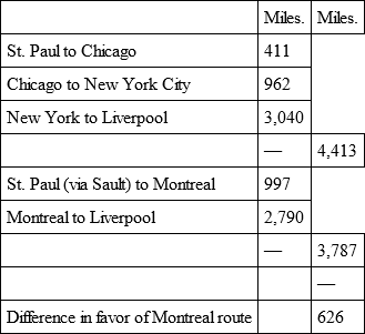
The following comparison of distance will be of interest to the people of the Northwestern States:
CHICAGO, BURLINGTON & NORTHERN RAILROAD
The Chicago, Burlington & Northern Company constructed a road from Chicago to Savannah, Illinois, and from that point up the Mississippi, along its east bank to St. Paul, crossing the St. Croix at Prescott. The road from Savannah to St. Paul is two hundred and eighty-five miles in length, and was completed in 1886. The cost complete, including rolling stock, was $30,000 per mile. The road was built on a grade of nine and eight-tenths feet to the mile, and its curvature nowhere exceeds three degrees in one hundred feet. The St. Croix, Chippewa, Wisconsin, Platte, Grant, and Fever rivers are crossed by iron bridges.
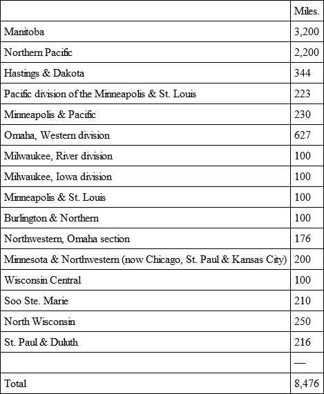
MILEAGE OF ROADS CENTRING IN ST. PAUL AND MINNEAPOLIS IN 1887
CONGRESSIONAL APPROPRIATIONS FOR THE IMPROVEMENT OF THE ST. CROIX RIVER
As early as 1858, when the writer was a member of the Minnesota senate, he introduced a memorial to Congress for the improvement of the St. Croix river, and of the Mississippi at Beef Slough bar, below Lake Pepin. This was the first memorial presented on this subject. Subsequent legislatures continued to memorialize Congress, but it was twenty years of continuous pleading before any attention was paid to the subject. In 1878 Thaddeus C. Pound, representing the St. Croix valley in Congress, secured the first appropriation. Mr. Pound also secured the first appropriation for the Mississippi reservoirs.
The following appropriations were made from time to time: 1878, $8,000; 1879, $10,000; 1880, $8,000; 1881, $10,000; 1882, $30,000; 1883, $7,500.
This money has been expended under the supervision of Maj. Farquier and Charles J. Allen of the United States engineering corps, with headquarters at St. Paul. The improvements carried out consisted in removing snags and all impediments in the channel or along shore, removing sandbars, thus deepening the channel, building wing dams, and riprapping the shores. The work has been well done, and the expenditure is a most judicious one.
INLAND NAVIGATION
As the prosperity of a country depends, next to its natural resources, upon the avenues of communication with other countries, the people of the Northwest naturally took a great interest in the improvement of their waterways. The states lying along the Mississippi and its tributaries found by these streams an advantageous southern outlet for their produce. But much needed to be done in the direction of improving navigation by clearing away obstructions, deepening the channels, and affording facilities for crossing rapids. As the settlements extended toward the great lakes, it became evident that the prosperity of the country would be greatly enhanced by communication with the lakes. In the absence or scarcity of navigable streams this communication, if obtained, must be by the improvement of navigation of the upper portion of these streams having their source near the lakes and their connection by canals with the lakes or their tributaries. By this means it was thought a better route to the Atlantic and to the Eastern States would be afforded for grain and other products than that afforded by the Mississippi. In the Minnesota state legislature of 1875 a bill was introduced making an appropriation of $10,000 for a survey of the route connecting the waters of Lake Superior with those of the St. Croix. This bill met with much opposition, but was finally passed, the amount having been reduced by amendment to $3,000. Lucas R. Stannard and Robert B. Davis were appointed commissioners, and with the meagre amount did all that was possible to be done in surveying the route. As the author of the bill, I insert here, as a matter of history, and as a sufficient explanation of my own views and those of the friends of the measure, a synopsis of the arguments presented to the senate advocating the measure:
"The route from Duluth via the lakes and St. Lawrence, and the Atlantic to England, according to correct computation, is about six hundred miles shorter than the route via Chicago and New York. The northern route is being made feasible by the improvements made by the British government on the Welland canal and Lachine rapids, and by the improvements made by our own government on the St. Clair flats and the Sault Ste. Marie canal, by which a depth of water is obtained sufficient to float vessels drawing twenty feet. This route to Europe will be traversed in much less time than the New York route. Vessels will be constructed for this inland American trade, and starting from the west end of Lake Superior with a cargo of grain that two weeks before was waving in the sunlight on northwestern prairies, will pass direct to Europe without breaking of bulk or reshipping, while the southern route requires reshipments at Buffalo and New York. Figures can scarcely do justice to the vast business that will be transacted on this open route as the northern part of the United States and the adjacent British possessions are settled.
"The opening of this route will tend to create new treaty stipulations and unlooked for interpretations of the old with the Dominion government, and establish commercial confidence and secure trade not realized to-day. Cheap transportation is the demand of the age, and this route will afford to the hundreds of millions of bushels of wheat and the commerce of Central North America the desired outlet to the best markets of the world. To many these ideas may seem chimerical, but we believe that the progress of the country and the development of her commerce in the not distant future will justify them, and that predictions now regarded as fanciful will be fulfilled to the letter.
"Minnesota as a state is just in the age of development. She is rising to power and influence. Much depends upon our legislature, more than depended upon the legislature of New York when, actuated by good counsels it connected the waters of the Hudson with those of Lake Erie by the 'Clinton Ditch,' so called in derision by the enemies of the measure. But the wisdom of Dewitt Clinton, the originator of that famous waterway, advanced the settlement of the great West at least a quarter of a century.
"Minnesota in her location holds the key that will unlock the largest body of fresh water on the globe, and open to it one of the most fertile and extensive wheat growing districts on the continent, a country that will soon vie with the country around the Black sea in the quantity and quality of its grain production.
"Shall we stand idly by whilst our neighboring states are moving to secure cheaper communications with the seaboard states? Cheap transportation, the lever that moves the world, is claiming the favorable attention of Congress, and men and means have been provided to ascertain the most feasible routes on which to bestow her aid for the transferring of the surplus products of the country to the markets of the East.
"The reports made thus far by the national committee make no allusion to Minnesota's great gateway to the East by Lake Superior, nor to the improvement of the Sault Ste. Marie canal. The committee dwelt somewhat elaborately upon the project of connecting the Mississippi with the lakes by means of a canal between the waters of Wisconsin and Fox rivers, neither of them good navigable streams. No authorized survey has ever commended this as a cheap route. Only one plan can be adopted by which a thoroughfare can be made profitable to the government and to the Northwest over this route, and that is to construct a ship canal along the Wisconsin river from the portage to the mouth.
"If the government can be prevailed upon to open up this route no one will deny that it will be of incalculable benefit to the people of Wisconsin, and to those further up the valley of the Mississippi. Let its friends do all they can to push forward the great movement.
"To Minnesotians I would say, let Wisconsin have much of our aid. I trust it will not take thirty-five years of the future to open up what thirty-five years of the past has projected. Wisconsin alone and unassisted ought to have accomplished this great work years ago, if the work could have been accomplished as cheaply as it has been represented.
"Let Minnesota look nearer home. The headwaters of the St. Croix are nearer to Lake Superior than those of any other navigable stream. Large Mississippi boats, whenever occasion has demanded, have made their way to the Dalles of the St. Croix. The falls and rapids above this point for a distance of four miles have a fall of but seventy-four feet, an elevation that could be overcome by means of locks. By means of wing dams at Kettle River falls, and other improvements at no very great cost, the river could be made navigable to the mouth of the Namakagon. This river, though put down as a tributary, is in reality the main stream, and can be navigated to Namakagon lake, which is but thirty miles from Ashland, and can be connected by a canal with Chequamegon bay, or with White river, a distance of only a few miles.
"If we pass up the St. Croix from the mouth of the Namakagon river, we shall find no serious obstructions to navigation till we reach the great dam built by the lumbermen twenty miles below Upper Lake St. Croix. The conformation here is of such a character that an inexhaustible supply of water can be held – more than three times what is held in the celebrated Summit lake in Ohio, which feeds the canal connecting the waters of the Ohio and Lake Erie. It is but a mile from the former lake to the source of Brule river, an affluent of Lake Superior, but as the waters of the Brule are rapid and the channel rocky, and its outlet is on a bleak and unhospitable stretch of lake shore, destitute of any harbor, we prefer the route from the Upper St. Croix lake to the bay of Superior, a distance of about thirty miles, a route well supplied by reservoirs of water, and with no difficult or insurmountable hills to overcome.
"Hon. H. M. Rice, who was one of the commissioners to survey the St. Marie's canal, pronounces this the most feasible and direct route for our contemplated canal.
"Other routes have been proposed, as from the St. Croix to the Nemadji and St. Louis rivers, but of the feasibility of these I am not so definitely informed.
"Believing, gentlemen of the senate, that you are in full accord with me that this great Northwest demands not only state aid in developing our natural resources, but the assistance of the general government, I recommend the proper presentation of this subject before Congress by our senators and representatives until our prayers are granted for the improvement of the same."
In the session of the Minnesota legislature of 1876 I again introduced a memorial to Congress asking for an appropriation of $10,000 to make a government survey of the St. Croix and Lake Superior routes.
George R. Stuntz, the veteran explorer, surveyor and civil engineer, who accompanied the United States reservoir commission to the Upper St. Croix waters, and who had made previous scientific examinations for the purpose of forming a correct idea of the contour of the summit dividing the waters flowing north and south, and of the practicability of constructing reservoirs, and of the cost of connecting the Lake Superior and St. Croix waters, makes the following report, which is valuable for the reliable data given:
"There are evidences that in the glacial period this was the channel through which flowed a river of ice, and that subsequently for a long period a vast volume of water coursed through this channel from Lake Superior to and down the Mississippi. The valley is everywhere of great width in proportion to the present volume of water, showing evidences of currents of great velocity fifty feet above the high water marks of the present time. These ancient banks of the river are composed of heavy drift gravel and boulders bearing the marks of the glacial action and having their origin north of Lake Superior. This valley extends across the height of land in township 45, in range 11 west, and in the northern part of it the Brule river rises and flows north into Lake Superior.
"At the copper range in township 48, range 10 west, section 23, a ledge of trap rock stands in the valley. In the eddy of this rock and extending to the southward or up the present stream is a well defined moraine of large boulders and gravel showing that the glacial river ran south. To the north of this point the Brule river makes a straight cut to the lake through sandy red clay deposits peculiar to that region.
"In this ancient valley the lowest point on the summit at the headwaters of these two streams is about 460 feet above Lake Superior [Lake St. Croix, at Stillwater, is 117 feet higher than Lake Superior] and 346 feet above Lake St. Croix. Upper Lake St. Croix is 12 feet below this summit. The St. Croix river one mile above the mouth of Moose river is 25 feet below this summit. The St. Croix river discharges 15.360 cubic feet of water per minute at the mouth of Moose creek. The Brule river discharges about 5.805 cubic feet of water per minute in the north part of township 46, range 10. The distance from Taylor's Falls to Lake Superior by the valley of the St. Croix and the valley of the Brule river is nearly 150 miles.
"There are several exposures of trap rock along these streams and an abundance of brown sandstone of good quality for building purposes, being easily worked.
"Can Lake St. Croix, at Stillwater, be connected with Lake Superior by canal and slackwater navigation? Yes. This question has been definitely settled by the recent examination of the United States engineers, under the direction of Maj. Chas. J. Allen, of the sources of the St Croix river, with reference to the construction of reservoirs to improve the navigation of that river and the Mississippi.
"By constructing a dam one mile above the mouth of Moose creek, on the St. Croix, of sufficient height to raise the water 25 feet, cutting a canal 75 feet wide, 12 feet deep, 1-1/2 miles long, across the summit, and building a dam in township 46, range 10, across the Brule river, high enough to raise the water to the same height as the dam on the St. Croix, and you construct a lake over thirty miles long, affording uninterrupted navigation across the summit for that distance, and utilize the waters of the St. Croix and its branches and the Brule, and by the capacity before given the amount of water is sufficient to pass vessels through locks 75 feet wide, 300 feet long, 12-1/2 feet lift, at the rate of 3 per hour, or 73 in 24 hours, at the dryest season of the year. This settles the question of practicability.
"The whole improvement will cost less than $8,000,000, and by placing the lowest dam and lock at Prescott so as to always hold Lake St. Croix at the high water mark will give two hundred miles of slackwater navigation connecting the Mississippi river with Lake Superior, accommodating boats of large size and deep draft, propelled by steam, at the usual rates of speed used on the rivers. Average cost per mile, $40,000.
"It would accomplish another object. The improvement of navigation on the Mississippi river by a system of reservoirs on its tributaries would be most effectually accomplished by holding one or two feet of extra head upon each of the thirteen dams proposed, thus storing up during the spring freshets vastly more water than can be held in the small reservoirs on the tributaries of the St. Croix. There are no very large natural reservoirs in the Upper St. Croix valley.
"Hold a three foot head on the lake as a reserve from the spring freshets and you have stored up 34,073,000 cubic yards of water to be used in the dry season in August and September. Continue this plan to the source and you have in the St. Croix valley a continuous reservoir one hundred and fifty miles long. Connect the two systems as proposed above and you have a route furnishing the cheapest transportation that can be had and at the same time obtain a system of large reservoirs to improve the navigation of the Mississippi river.
"This is one of the improvements that the Northwest needs for its present, future and more perfect development.
"The proposition and figures are given, after a series of examinations extending through a period of over twenty-five years, for the purpose of calling out investigation."
THE WATERWAYS CONVENTION OF 1885
Public discussions of the matter in the legislature and in conventions were not entirely in vain. Public attention was aroused and interest awakened in the great question of inland navigation. In 1885 the great waterways convention convened in St. Paul, at the call of Gov. Hubbard, of Minnesota. This convention was attended by over 1,000 delegates from the states of Florida, Louisiana, Missouri, Kansas, Nebraska, Illinois, Iowa, Wisconsin, and Minnesota, and from the territories of Dakota and Montana. Ex-Gov. Bross, of Illinois, acted as temporary chairman. The permanent organization elected Maj. Wm. Warren, of Kansas City, president, Gen. G. W. Jones, of Iowa, vice president, and Platt B. Walker, of Minnesota, secretary.