

 полная версия
Fifty Years In The Northwest
The heretofore mentioned treaties include all the lands within the state of Minnesota originally owned by Indian tribes, except the Red Lake reservation, and for its cession a treaty was negotiated in 1886, which to this date, April, 1888, has not been ratified.
GEN. PIKE AND THE INDIANS
Gen. Zebulon M. Pike, United States Army, was sent by the government in 1805-6 on a tour of inspection, to select sites for forts, and to treat and hold councils with the various Indian tribes of the Upper Mississippi. He met the Sioux in council at the junction of the St. Peter's and Mississippi rivers, Sept. 23, 1805, and informed them that he came to purchase lands for government forts, and to tell them what the Great Father at Washington desired them to know about his people and their government. A part of his speech we subjoin:
"Brothers: You old men probably know that about thirty years ago we were subject to the king of England, and governed by his laws. But he not treating us as children we refused to acknowledge him as father. After ten years of war, in which he lost 100,000 men, he acknowledged us as a free and independent nation. They knew that not many years since we received Detroit, Michilmackinac, and all the ports on the lakes from the English, and now but the other day, Louisiana from the Spanish; so that we put one foot on the sea at the east, and the other on the sea at the west, and if once children are now men; yet I think that the traders who come from Canada are bad birds amongst the Chippewas, and instigate them to make war on their red brothers, the Sioux, in order to prevent our traders from going high up the Mississippi. This I shall inquire into, and so warn those persons of their ill conduct.
"Brothers, I expect that you will give orders to all your young warriors to respect my flag and protection, which I may send to the Chippewa chief who may come down with me in the spring; for was a dog to run to my lodge for safety, his enemy must walk over me to hurt him.
"Brothers, I am told that the traders have made a practice of selling rum to you. All of you in your right senses must know that this is injurious and occasions quarrels, murders, etc., amongst yourselves. For this reason your father has thought proper to prohibit the traders from selling you rum.
"Brothers, I now present you with some of your father's tobacco, and some other trifling things, as a memorandum of my good will, and before my departure I will give you some liquor to clear your throats."
At this conference the Sioux granted to the United States government a tract nine miles square at the mouth of the St. Croix, and a similar tract at the mouth of the St. Peter's, lying on both sides of the Mississippi and including the falls of St. Anthony. Pike says: "They gave the land required, about 100,000 acres of land (equal to $200,000), and promised me a safe passage for myself and any chief I might bring down. I gave them presents to the amount of about two hundred dollars, and as soon as the council was over allowed the traders to present them with liquor which, with what I gave, was equal to sixty gallons." Pike in his journeying through the territory ordered Dickson and others to haul down the British flag. It is on record that the flags were hauled down, but also that they were hoisted again after Pike's departure.
From Pike's own account of one of his inland tours he was hospitably entertained by his red brothers, as the following paragraph from his journal will show:
"After making this tour we returned to the chief's lodge and found a berth provided for each of us, of good soft bear skins nicely spread, and on mine there was a large feather pillow. I must not here omit to mention an anecdote which serves to characterize more particularly their manners. This, in the eyes of the contracted moralist, would deform my hospitable host into a monster of libertinism; but by a liberal mind would be considered as arising from the hearty generosity of the wild savage. In the course of the day, observing a ring on one of my fingers, he inquired if it was gold; he was told it was the gift of one with whom I should be happy to be at that time; he seemed to think seriously, and at night told my interpreter, 'that perhaps his father (as they all called me) felt much grieved for the want of a woman; if so, he could furnish him with one.' He was answered that with us each man had but one wife, and that I considered it strictly my duty to remain faithful to her. This he thought strange (he himself having three) and replied that 'he knew some Americans at his nation who had half a dozen wives during the winter.' The interpreter observed that they were men without character; but that all our great men had each but one wife. The chief acquiesced; but said he liked better to have as many as he pleased."
The Establishment of United States Surveys in the Northwest – A Condensed Statement from the Records of the Books in the Surveyor General's OfficeOn the twenty-sixth day of January, 1796, when the American Congress was in session at Philadelphia, a bill was reported for establishing land offices in the Northwestern Territory. The bill was ably discussed and there was much variance of opinion as to the disposition of the lands to be surveyed and brought into the market. Some favored a proposition to give the lands to actual settlers, and others favored selling the lands at a stipulated price, applying the proceeds to the payment of the national debt. The bill, when agreed upon, bore the following title: "An act providing for the sale of the lands of the United States in the territories northwest of the river Ohio, and above the mouth of the Kentucky river." The bill was approved by President Washington May 18, 1796.
This law established the office of surveyor general with powers specifically limited. It directed him to run lines north and south according to the true meridian, to be known as range lines, and others, crossing them at right angles, to be known as township lines, the townships thus formed to consist of areas six miles square, the whole to be subdivided into 36 sections, each a mile square, each to contain 640 acres of land, as near as may be, and to be subdivided into quarters, containing 160 acres, and these quarters to be further subdivided into forties. Marks were to be established at the corners of every township and section. These surveys were not to conflict with Indian treaty and military land warrants, or the course of navigable waters.
This admirable device for surveying the public lands grew out of a correspondence between Gen. Rufus Putnam and President Washington, in 1875, in which the former proposed the division of the public lands into townships six miles square, to be marked by township and range lines. Perhaps no more convenient and acceptable plan of survey could have been devised. Gen. Benjamin Tupper was one of a company of surveyors in 1796 that established the first lines under this new system. This survey was made in Southeast Ohio.
The first surveyor general's office was opened at Marietta, Ohio, soon after the approval of the bill, and Rufus Putnam was appointed surveyor general. In 1803 he was removed by President Jefferson and the office was located at Vincennes. A year later it was removed to Cincinnati, in 1814 to Chillicothe, in 1829 to Cincinnati, in 1845 to Detroit, and in 1857 to St. Paul, where it has since remained. The act for the survey of the public lands has since been modified and improved. In 1804 an act was approved providing for the marking of quarter sections on the section lines.
By the same law under which the lands were subdivided and opened to the public, one section, No. 16, in every township was reserved from sale for the support of common schools. Two townships were also set apart for the support of a university. This was the beginning of the donations of land for school and other purposes.
THE UNITED STATES LAND OFFICE
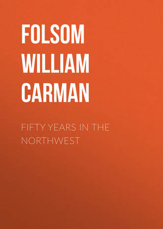
The first government land office in Wisconsin north of Mineral Point was located at St. Croix Falls in 1848. Township plats were received, lands advertised and offered for sale in September, covering the ground where the cities of Stillwater and St. Paul are now located, and adjacent country. The office was removed to Stillwater in 1849, and the land district divided by the St. Croix river. The land office for the east side was located at Willow River in 1849, and there remained till 1860, when it was removed to St. Croix Falls. The following are the receivers and registers:
1848. Samuel Leach, receiver; Charles S. Whiting, register.
1849. Moses S. Gibson, receiver; T. D. Catlin, register.
1853. Otis Hoyt, receiver; John O. Henning, register.
1857. J. D. Reymert, receiver; J.B. Spencer, register:
1859. Orpheus Evarts, receiver; J. B. Spencer, register.
1861. Benj. W. Reynolds, receiver; Michael Field, register.
1864. Hiram Calkins, receiver; Michael Field, register.
1869. Fayette Allen, receiver; Michael Field, register.
1871. Joel F. Nason, receiver; Michael Field, register.
1884. Alvah A. Heald, receiver; Michael Field, register.
1887. Alvah H. Heald, receiver; Wm. M. Blanding, register.
The first entry in the new district, Aug. 17, 1849, was by W. S. Hungerford. Lot 4, Sec. 19, and Lots 1, 2, 3, Sec. 30, T. 34, R. 18, where the village of St. Croix now stands. The second entry was by George Brownell, Lot 3, Sec. 20, T. 24, R. 18. The oldest record to be found in the office is the proving up by James Purinton of his pre-emption, July 24, 1848. The first recorded correspondence is a letter from S. Leach, receiver, to Geo. W. Jones, surveyor general, Dubuque, Iowa. In June, 1863, under the receivership of Mr. Reynolds, the safe in the office was blown open with powder and the contents stolen. Some time afterward, in 1865, fifty land warrants and a bunch of keys from the articles missing were thrown in at the office window. They had the appearance of having been buried in the ground.
FIRST ENTRIES
July 24, 1848. James Purinton, residence, St. Croix Falls. Lot 1, in east fractional part Sec. 23, T. 29 north, R. 20 west, and W. 1/2 of N. W. 1/4 and S. E. 1/4 of N. W. 1/4, Sec. 24, T. 29, R. 20, 137 70-100 acres; price, $1.25; cost, $172 12-100, silver; pre-emption act, 1841. This pre-emption is where the dam and mills have since been erected at North Hudson.
Aug. 12, 1848. Samuel Burkelo, Orange Walker and Hiram Berkey. Lots 7 and 8, west of river, Sec. 6, T. 31, R. 19, 108 25-100 acres; cost $135 43-100, 1/4 gold; pre-emption act, 1840 (Marine Mills).
Aug. 16, 1848. Richard Freeborn. West 1/2 of N. W. 1/4 and N. E. 1/4 of N. W. 1/4, and Lot 3, Sec. 12, T. 28, R. 23, St. Paul; pre-emption act, 1841.
The first land offered at public auction sale was Aug. 27, 1848.
4. Albert Henry Judd, Orange Walker, Samuel Burkelo, Hiram Berkey, George Baldwin Judd, Asa Parker were the purchasers of Lots 5 and 6, Sec. 7, T. 31, R. 19, west of river; cost, $106 46-100, gold.
5. Martin Mower, David B. Loomis; Lots 7 and 8, Sec. 29, T. 31, R. 19, west of river; cost, $54 81-100, 1/4 gold (now Arcola).
6. John Allen; Lots 4 and 5, Sec. 2, T. 29, R. 20, west of river; gold (Allen's Point, now South Stillwater).
7. Eleazer R. Steves; Lots 1 and 2, Sec. 14, T. 29, R. 20, east of river; gold, $9.66; silver, $54.85; $64 51-100 (now Hudson).
8 and 9. Stephen Harris; N. 1/2 of S. E. 1/4 and E. 1/2 of S. W. 1/4, Sec. 22, T. 29, R. 20.
10. Himan W. Greely; E. 1/2 of N. E. 1/4, Sec. 22, T. 29, R. 20, gold.
11 and 12. Albert N. Judd; W. 1/2 of S. E. 1/4 and E. 1/2 of S. W. 1/4, Sec. 22, T. 29, R. 20, gold.
13 and 14. Louis Massey; E. 1/2 of S. W. and Lots 1 and 2, Sec. 24, T. 29, R. 20, silver; east of Lake St. Croix (now Hudson).
15 and 16. Peter F. Bouchea, Lot 1, east of river, Sec. 25, T. 29, R. 20 and Lot 2, Sec. 25, T. 29, R. 20; gold, $63 22-100; silver, $10 – $73 22-100.
17 and 18. John O'Brien; Lot 3, Sec. 26, T. 29, R. 20 and W. 1/2 of S. W. 1/4, Sec. 26, T. 29, R. 20, silver and gold (now Lakeland).
19 and 20. Albert H. Judd; E. 1/2 of N. E. 1/4, and W. 1/2 of N. W. 1/4, Sec. 22, T. 29, R. 20, gold.
21. Himan W. Greely; W. 1/2 of N. E. 1/4, Sec. 22, T. 29, R. 20, gold.
The above are all the purchasers at the first sale of land in the valley at St. Croix Falls. Sale was continued from day to day until townships 25 to 31 of ranges 19 and 20 were offered, covering the settlement of St. Anthony Falls, St. Paul, Cottage Grove, and Point Douglas.
The United States land office was moved from St. Croix Falls to Stillwater in September, 1849. The first public sale of lands at Stillwater was Oct. 9, 1849. The office was held in Stillwater nine years. In October, 1858, it was moved to Cambridge, Isanti county; November 3d the first sale of lands was held at Cambridge. April 7, 1860, the office was burned, many valuable papers were destroyed, and many records were replaced from the archives at Washington. July 5, 1860, the office was moved to Sunrise, and Oct. 8, 1868, it was moved to Taylor's Falls, where it is at the present time (1888).
LIST OF OFFICERS
The records do not show the date of commission of any officer; we gather the dates as near as possible from recorded correspondence.
TERRITORIAL GOVERNMENT OF WISCONSIN
Governors: Henry Dodge, 1836-41; James Duane Doty, 1841-44; N. P. Talmadge, 1844-45; Henry Dodge, 1845-48.
Delegates to Congress: George W. Jones, 1836-37; James D. Doty, 1837-41; Henry Dodge, 1841-45; Morgan L. Martin, 1845-47; John H. Tweedy, 1847-48.
Chief Justice: Charles Dunn, 1836-48.
FIRST LEGISLATURE – REPRESENTATIVES OF CRAWFORD COUNTY
First Session, 1836 – Council: Thomas P. Burnett.6 (Rejected by a ruling of Gov. Dodge, and district left without representation.) House: James H. Lockwood, James B. Dallam.
Second Session, 1837 – House: Ira B. Brunson, Jean Brunet.7
Third Session, 1838 – House: Ira B. Brunson, Jean Brunet.
SECOND LEGISLATURE
First Session, 1838 – Council: George Wilson. House: Alex. McGregor.8
Second Session, 1839 – Council: George Wilson. House: Alex. McGregor, Ira B. Brunson.
Third Session, 1839-40 – Council: Joseph Brisbois. House: Alex. McGregor, Ira B. Brunson.
Fourth Session, 1840 – Council: Charles J. Learned. House: Alex. McGregor, Ira B. Brunson.
THIRD LEGISLATURE – REPRESENTATIVES OF CRAWFORD AND ST. CROIX COUNTIES
First Session, 1840-41 – Council: Charles J. Learned. House: Alfred Brunsou, Joseph R. Brown.
Second Session, 1841-42 – Council: Charles J. Learned. House: Joseph R. Brown, Theophilus J. LaChapelle.
FOURTH LEGISLATURE
First Session, 1842-43 – Council: Theophilus La Chapelle. House: John H. Manahan.
Second Session, 1843-44 – Council: Theophilus La Chapelle. House: John H. Manahan.
Third Session, 1845 – Council: Wiram Knowlton. House: James Fisher.
Fourth Session, 1846 – Council: Wiram Knowlton. House: James Fisher.
FIFTH LEGISLATURE
First Session, 1847 – Council: Benj. F. Manahan. House: Joseph W. Furber.
CRAWFORD, ST. CROIX, CHIPPEWA AND LA POINTE COUNTIES
Special Session, 1847 – Council: Benj. F. Manahan. House: Henry Jackson.
Second Session, 1848 – Council: Benj. F. Manahan. House: Henry Jackson.
First Constitutional Convention, Oct. 5, 1846 – Delegate from St. Croix county, Wm. Holcombe.
Second Constitutional Convention, Dec. 15, 1847 – Delegate from St. Croix county, George W. Brownell.
STATE GOVERNMENT OF WISCONSIN
Governors: Nelson Dewey, 1848-52; L. J. Farwell, 1852-54; W. A. Barstow, 1854-56; Coles Bashford, 1856-58; Alex. W. Randall, 1858-62; Louis P. Harvey, 1862; Edward Salomen, 1862-64; James Q. Lewis, 1864-66; Lucius Fairchild, 1866-72; C. C. Washburn, 1872-74; Wm. R. Taylor, 1874-76; Harrison Luddington, 1876-78; Wm. E. Smith, 1878-82; Jeremiah Rusk, 1882-58.
UNITED STATES SENATORS
Isaac P. Walker, June 8, 1848; Henry Dodge, June 8, 1848; Charles Durkee, Feb. 1, 1855; James R. Doolittle, Jan. 23, 1857; Timothy O. Howe, Jan. 23, 1861; Matt H. Carpenter, Jan. 26, 1869; Angus Cameron, Feb. 3, 1875; Philetus Sawyer, Jan. 26, 1881; John C. Spooner, Jan. 26, 1885.
UNITED STATES REPRESENTATIVES
From districts bordering on the St. Croix: Mason C. Darling, 1848-50; Orasmus Cole, 1850-52; Ben. C. Eastman, 1852-56; C. C. Washburn, 1856-62; Luther Hanchett, 1862-63; Walter D. McIndoe, 1863-68; C. C. Washburn, 1868-72; Jeremiah M. Rusk, 1874-78; Hiram L. Humphrey, 1878-84; Wm. T. Price, 1884-88; Nels P. Haugan, 1888.
District judges presiding in territory originally included in St. Croix county:
Wiram Knowlton, of Prairie du Chien, 1848-50; district – Crawford, Chippewa, St. Croix and La Pointe counties.
S. S. Fuller, of Hudson, 1850-60; district – Pierce, St. Croix, Polk, Douglas, and La Pointe counties.
Henry D. Barron, of North Pepin, 1860-61; district – Pierce, St. Croix, Polk, Douglas, Ashland, and Bayfield counties.
L. P. Weatherby, of Hudson, 1861-67; district – Pepin, Pierce, St. Croix, Polk, Burnett, Douglas, Bayfield, and Ashland counties.
Herman L. Humphrey, of Hudson, 1867-77; district – St. Croix, Pierce, Pepin, Dunn, and Barron counties.
Solon S. Clough, of Hudson, 1864-76; district – Polk, Burnett, Douglas, Ashland, and Bayfield counties.
R. P. Bundy, of Menomonie, 1876-85, re-elected until 1891; district – Buffalo, Dunn, Eau Claire, Pepin, Pierce; and St. Croix counties.
Henry D. Barron, of St. Croix Falls, 1876-82; district – Chippewa, Barron, Polk, Burnett, Douglas, Ashland, and Bayfield counties.
Solon S. Clough, of Superior, 1882-88; district – Ashland, Barron, Bayfield, Burnett, Chippewa, Douglas, Polk, and Washburn counties.
R. D. Marshall, of Chippewa Falls, 1888.
WISCONSIN STATE LEGISLATURE
Representatives of territory originally included in St. Croix county:
First Session, 1848 – Senate: Daniel S. Fenton. Assembly: W. R. Marshall. (Seat successfully contested by Joseph Bowron.)
Second Session, 1849 – Senate: James Fisher. Assembly: Joseph Bowron.
Third Session, 1850 – Senate: James Fisher. Assembly: John S. Watrous.
Fourth Session, 1851 – Senate: Henry A. Wright. Assembly: John O. Henning.
Fifth Session, 1852 – Senate: Henry A. Wright. Assembly: Otis Hoyt.
Sixth Session, 1853 – Senate: Benj. Allen. Assembly: Orrin T. Maxson.
Seventh Session, 1854 – Senate: Benj. Allen. Assembly: Wm. M. Torbert.
Eighth Session, 1855 – Senate: Wm. T. Gibson. Assembly: Smith R. Gunn.
Ninth Session, 1856 – Senate: Wm. T. Gibson. Assembly: Almon D. Gray.
Tenth Session, 1857 – Senate: Wm. Wilson. Assembly: Orin T. Maxson.
Eleventh Session, 1858 – Senate: Daniel Mears. House: James B. Gray, Lucius Cannon.
Twelfth Session; 1859 – Senate: Daniel Mears. House: Moses S. Gibson. Mr. Gibson's seat successfully contested by M. W. McCracken.
Thirteenth Session, 1860 – Senate: Charles B. Cox. House: Asaph Whittlesey.
Fourteenth Session, 1861 – Senate: Charles B. Cox. House: John Comstock.
Fifteenth Session, 1862 – Senate: H. L. Humphrey. House: George R. Stuntz, James W. Beardsley. Mr. Beardsley was elected speaker of the house.
Sixteenth Session, 1863 – Senate: N. L. Humphrey. House: Henry D. Barron, Charles B. Cox.
Seventeenth Session, 1864 – Senate: Austin H. Young. House: Henry D. Barron, Joseph S. Elwell.
Eighteenth Session, 1865 – Senate: Austin H. Young. House: Amos S. Gray (successfully contested by A. C. Stuntz). House: Marcus A. Fulton.
Nineteenth Session, 1866 – Senate: Marcus A. Fulton. House: Henry D. Barron, William J. Copp. Mr. Barron elected speaker of the assembly.
Twentieth Session, 1867 – Senate: Marcus A. Fulton. House: Henry D. Barron, John D. Trumbull, H. L. Wadsworth.
Twenty-first Session, 1868 – Senate: Wm. J. Copp. House: Henry D. Barron, Eleazer Holt, Marcus A. Fulton.
Twenty-second Session, 1869 – Senate: Wm. J. Copp. House: Henry D. Barron, Edward H. Ives, Charles D. Parker.
Twenty-third Session, 1870 – Senate: Edward H. Ives. House: Samuel B. Dressor, Oliver S. Powell, Charles D. Parker.
Twenty-fourth Session, 1871 – Senate: Edward H. Ives. House: Samuel S. Vaughn, Oliver S. Powell, Ruel K. Fay.
Twenty-fifth Session, 1872 – Senate: Joseph E. Irish. House: Henry D. Barron, Oliver S. Powell, John C. Spooner.
Twenty-sixth Session, 1873 – Senate: Joseph E. Irish. House: Henry D. Barron, speaker; James H. Persons, David C. Fulton.
Twenty-seventh Session, 1874 – Senate: Henry D. Barron. House: Samuel S. Fifield, James H. Persons, Harvey S. Clapp.
Twenty-eighth Session, 1875 – Senate: Henry D. Barron, House: Samuel S. Fifield, Thomas S. Nelson, Philo Q. Boyden.
Twenty-ninth Session, 1876 – Senate: Henry D. Barron. House: Samuel S. Fifield, speaker; Christopher L. Taylor, Philo Q. Boyden.
Thirtieth Session, 1877 – Senate: Samuel S. Fifield. House: Woodbury S. Grover, Ellsworth Burnett, Guy W. Dailey.
Thirty-first Session, 1878 – Senate: Dana R. Bailey. House: Canute Anderson, Charles A. Hawn, James Hill.
Thirty-second Session, 1879 – Senate: Dana R. Bailey. House: Wm. J. Vincent, Nils P. Haugen, James Hill.
Thirty-third Session, 1880 – Senate: Sam S. Fifield. House: Nils P. Haugen, James Hill, Lars L. Gunderson.
Thirty-fourth Session, 1881 – Senate: Sam S. Fifield. Assembly: Geo. D. McDill, Franklin L. Gibson, Merton Herrick.
Thirty-fifth Session, 1882 – Senate: James Hill. Assembly: Geo. D. McDill, Franklin L. Gibson, speaker; Olof A. Sangestad.
Thirty-sixth Session, 1883 – Senate: James Hill. Assembly: Canute Anderson, John D. Putnam, Geo. D. McDill, James Johnston.
Thirty-seventh Session, 1884 – Senate: Joel F. Nason. Assembly: Hans B. Warner, Frank M. Nye, Thomas Porter; Charles S. Taylor, J. B. Thayer.
(For thirty-eighth and thirty-ninth Sessions see Addenda.)
TERRITORIAL GOVERNMENT OF MINNESOTA
Governors: Alexander Ramsey, from June 1, 1849, to May 15, 1853; Willis A. Gorman, from May 15, 1853, to April 23, 1857; Samuel Medary, from April 23, 1857, to May 24, 1858.
Delegates to Congress: Henry H. Sibley, Jan. 15, 1849, to March 4, 1853; Henry M. Rice, Dec. 5, 1853, to March 4, 1857; W. W. Kingsbury, Dec. 7, 1857, to May 11, 1858.
Chief Justices: Aaron Goodrich, June 1, 1849, to Nov. 13, 1851; Jerome Fuller, Nov. 13, 1851, to Dec. 16, 1852; Henry Z. Hayner, Dec. 16, 1852, to April 7, 1853 (Judge Hayner never presided at a single term and gave but one decision, which was to pronounce the prohibition law unconstitutional); William H. Welch, April 7, 1853, to May 24, 1858.
Associate Justices: David Cooper, June 1, 1849, to April 7, 1853; Bradly B. Meeker, June 1, 1849, to April 7, 1853; Andrew G. Chatfield, April 7, 1853, to April 23, 1857; Moses G. Sherburne, April 7, 1853, to April 13, 1857; R. R. Nelson, April 23, 1857, to May 24, 1858; Charles E. Flandrau, April 23, 1857, to May 24, 1858.
CENSUS OF THE TERRITORY – AUGUST, 1849
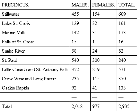
Upon the basis of this population the governor established the following legislative districts:
First district: St. Croix precinct, extending on the west side of the St. Croix and Mississippi rivers to the Iowa line; Second district: Stillwater; Third district: St. Paul; Fourth district: Marine Mills and the country north to the British possessions; Fifth district: St. Anthony Falls; Sixth district: The country east of the Mississippi not embraced in the Fourth district, and extending north to the British possessions; Seventh district: All the territory on the west of the Mississippi river not embraced in the sixth and first districts.
FIRST TERRITORIAL LEGISLATURE. – HELD SEPT. 3 TO NOV. 1, 1849