

 полная версия
Fifty Years In The Northwest
1858. Minnesota admitted as a state. State loan of $250,000 guaranteed. The $5,000,000 loan bill adopted.
1859. Hard times. Work on the land grant road ceases. Collapse of the $5,000,000 scheme. First export of grain this fall.
1860. Federal census, 172,123.
1861. April 13th. President's proclamation for troops received. The First regiment recruits at once. June 22d it embarks at Fort Snelling for the seat of war.
1862. Call for 600,000 men. August 17th, massacre at Acton; 18th, outbreak at Lower Sioux agency; 19th, New Ulm attacked; 20th, Fort Ridgely attacked; 25th, second attack on New Ulm; 30th, Fort Abercrombie besieged; September 1st, the bloody affair at Birch Coolie; 19th, first railroad in Minnesota in operation between St. Paul and Minneapolis; 22d, battle of Wood Lake; 26th, captives surrendered at Camp Release; military commission tries 321 Indians for murder, rape, etc.; 303 condemned to die; December 26th, 38 hanged at Mankato.
1863. Gen. Sibley's expedition to the Missouri river. July 3d, Little Crow killed; 24th, battle of Big Mound; 26th, battle of Dead Buffalo Lake; 28th, battle of Stony Lake. Treaty at crossing of Red Lake river with Chippewas, and cession of Dakotah lands, October 2d.
1864. Large levies for troops. Expedition to Missouri river under Sully. Inflation of money market. Occasional Indian raids.
1865. Peace returns. Minnesota regiments return and are disbanded; in all 25,052 troops furnished by the State. Census shows 250,000 inhabitants.
1866-72. Rapid railroad building everywhere, immigration heavy, "good times" prevail, and real estate inflated.
1873. January 7th, 8th and 9th, polar wave sweeps over the State; seventy persons perish. September, the Jay Cooke failure creates another panic. Grasshopper raid begins and continues five seasons.
1876. September 7th, armed outlaws from Missouri attack a Northfield bank. Three killed, three prisoners.
1877. Minnesota legislature adopts biennial sessions.
1878. May 2d, three flouring mills at Minneapolis explode; eighteen lives lost.
1880. November 15th, hospital for the insane at St. Peter partly destroyed by fire; twenty-five lives lost.
1881. March 1, capitol at St. Paul destroyed by fire.
1886. Cyclone destroys Sauk Rapids. Wisconsin legislature adopts biennial sessions.
THE BOUNDARY QUESTION
The question of the western boundary of Wisconsin had been agitated since the Martin bill for the organization of the State had been introduced in 1846. This bill established the present boundary. The majority of the people residing in the valley of the St. Croix were opposed to it on the ground that the interests of the valley on both sides were identical, and that it was not proper that the two sides should be separated by a state line. The question became a political one, and at the election of delegates for the constitutional convention of Oct. 5, 1846, Wm. Holcombe was elected over Joseph Bowron, as representing the sentiments of the people of the valley as opposed to the proposed boundary line.
In convention Mr. Holcombe advocated a boundary line commencing at Mount Trempeleau on the Mississippi, running due north to Lake Superior. Failing in this, he advocated a boundary line to be established at a point fifteen miles due east of the most easterly point on Lake St. Croix, said line extending from that point due south to the Mississippi and due north to the tributary waters of Lake Superior. In this he was successful, and the constitution in which this boundary line was thus fixed went to the people and was rejected, greatly to the disappointment of the people of the St. Croix valley, who felt that they had been unjustly dealt with. There seems, indeed, to be but little excuse for the attitude of the majority of the citizens of Wisconsin with regard to this boundary. Certainly but little attention was shown to the interests of the people in the western section of the Territory.
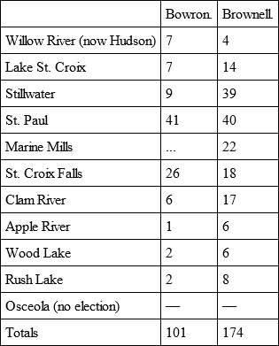
Prior to the meeting of the second constitutional convention, Dec. 15, 1847, public meetings were held at St. Croix Falls and in Stillwater, at which latter place enthusiastic resolutions were passed remonstrating against this unnatural boundary, which resolutions were signed by nearly all the citizens of the St. Croix valley, and a few in and around St. Paul, asking the convention to establish the western boundary on a line running due north from the foot of Lake Pepin to Lake Superior. George W. Brownell was elected from the St. Croix district to the second convention, with instructions to work for this boundary. Joseph Bowron, Brownell's opponent, was defeated by a large majority. The following is the abstract of votes:
Mr. Brownell made strong and persistent efforts to have the boundary line adjusted in accordance with the sentiments of the people of the valley, but in vain. Morgan L. Martin, delegate to Congress from Wisconsin Territory, had framed the bill establishing the present boundary, and it was urged that any effort to change the line would tend to prevent the immediate admission of the State, and it was thought a political necessity that the State should be admitted at once, that it might take part in the ensuing presidential election. Under such pressure the convention made haste to adopt, and the people to accept, a constitution with boundary lines that should never have been made. The State was admitted in time to cast its electoral vote for Gen. Zachary Taylor and Millard Fillmore.
At a meeting held by the people of the St. Croix valley, subsequent to this convention and prior to its adoption by the people, the following resolutions were passed, and we append them as expressing very generally the sentiments of the people of the valley:
Whereas, By the establishment of the St. Croix river as a part of the boundary line between the State and territory of Wisconsin, the inhabitants of our remote settlements are greatly aggrieved, our local rights and privileges neglected and abridged, our geographical, material and natural political alliance with our neighbors of the new territory will be cut off; and
Whereas, Our oft repeated remonstrances and appeals to the authorities of the new state have been unavailing; therefore
Resolved, That the establishment of the St. Croix river as a part of the boundary of the state of Wisconsin, against the will of the inhabitants of the valley of said river, is unjust, unreasonable and contrary to the principles upon which our government is founded.
Resolved, That in establishing the present boundary, our known and acknowledged wishes and interests are invaded by the might of a majority; that as the boundary is now established, so great is the distance and obstacles intervening, severing us, together with the people of Lake Superior, from the seat of government, that we can not enjoy a prompt and equitable share in representation, and we would respectfully admonish our brethren that equal representation involves a principle which is deeply and peculiarly American.
Resolved, That the interests of the inhabitants of St. Croix, being identical from the nature of the staple business of the country, the river being the natural centre to which all the business of the valley tends, a boundary severing the natural ties in connection is uncalled for, inconvenient and vexatious.
Resolved, That the inhabitants of the territory of the whole Northwest are deeply interested in procuring a just and wise alteration of the present line of divisions, because from the geography of the country, the line as now established, we are robbed of a future star in the galaxy of the American sisterhood of states.
Resolved, That we pledge ourselves to stand united and unceasingly use all honorable means in our power to procure the establishment of a boundary east of St. Croix valley.
Resolved, That a committee of three be appointed to prepare and forward a memorial to the present legislature on this subject.
The resolutions as a whole were unanimously adopted.
In accordance with the last resolution the chair appointed Wm. R. Marshall, G. W. Brownell and W. H. C. Folsom, Esqs., a committee.
On motion the secretary was instructed to forward copies of the proceedings of the meeting to the Prairie du Chien Patriot, Galena Gazette and Wisconsin Argus, requesting their publication.
H. H. Perkins,Chairman.R. V. D. Smith,Secretary.No attention was paid to the action of the public meeting. It is possible that none was expected. It was some satisfaction to the people of the valley to give such an expression of their opinion of the wrong done them. The admission of Wisconsin with the St. Croix as a boundary line left the country immediately west of that river virtually without law. Nevertheless, Wisconsin territorial laws were acknowledged west of the St. Croix and were generally considered binding until a new territorial government should be organized. The territorial governor, Gen. Henry Dodge, had been elected United States senator and therefore could not claim jurisdiction over this part of the territory lying beyond state limits. John Catlin, territorial secretary, held that the territorial government still existed in the part of the original territory excluded.
At a public meeting held in Stillwater, Aug. 26, 1848 (a preliminary meeting having been held August 24th, at which an understanding was effected with Mr. Catlin and he invited to exercise authority as a territorial officer), steps were taken for the organization of a new territory, and Mr. Catlin, having removed to Stillwater, issued a proclamation in his official capacity, ordering an election to be held for the selection of a delegate to Congress. To facilitate this movement John H. Tweedy, territorial delegate from Wisconsin, resigned. The election was held Oct. 30, 1848, and H. H. Sibley was elected as a successor to John H. Tweedy, his papers being certified by John Catlin, secretary of Wisconsin Territory. Mr. Sibley proceeded to Washington, presented his credentials and patiently awaited recognition, which was not very speedily accorded, there being considerable discussion as to the right of excluded territory to continued political existence. His admission, on the fifteenth of January, as a delegate, settled the question and established a precedent that the creation of a state government does not deprive portions of the territory not included within state limits of the right to existence and representation. Mr. Sibley ably presented the claims of his constituents and with great difficulty succeeded in procuring the passage of a bill organizing the new territory of Minnesota.
With all respect to the action of Congress in receiving Mr. Sibley as a legally elected delegate (and, under the circumstances, the action seems wise), the question still rises: "Had we a legal territorial government?" If we had, what was the necessity for a new organization? Why could not the excluded territory continue under the old regime, or inherit, so to speak, the old government machinery? If we had no legal existence, by what authority could Mr. Sibley represent us? The Wisconsin territorial government had ceased to exist. Ours had not begun to live.
The territory of Minnesota was created by act of Congress, March 3, 1849, a little over thirty days after the introduction of the bill creating it. There had been some discussion as to the name. In the bill presented by Morgan L. Martin it was named Minnesota. Senator Stephen A. Douglas, chairman of the committee on territories, recommended the passage of the bill, and that the new territory be named Itasca. When the bill was before the house the names Chippewa, Jackson and Washington were proposed, but the name in the original bill was adopted. It is a compound word, taken from the Sioux language, and has for its meaning "Land of sky-tinted water." The news of the passage of the bill reached Stillwater April 9th, and was received with great rejoicing.
The United States land office which had been established at St. Croix Falls in 1848 was removed to Stillwater July 1, 1849. Abraham Van Voorhes was appointed register and William Holcombe receiver.
INDIAN TREATIES
Sept. 23, 1805, at the mouth of St. Peter's river (now Mendota) with the Sioux. (For account of this treaty see "Gen. Pike and the Indians.")
July 29, 1837, at St. Peter (now Mendota), Wisconsin Territory, the Chippewa Indians ceded to the United States the following tract of country: Beginning at the junction of the Crow Wing and Mississippi rivers, between twenty and thirty miles, above where the Mississippi is crossed by the forty-sixth parallel of north latitude, and running thence to the north point of Lake St. Croix, one of the sources of the St. Croix river; thence to and along the dividing ridge between the waters of Lake Superior and those of the Mississippi, to the sources of the Ochasua-sepe, a tributary of the Chippewa river; thence to a point on the Chippewa river twenty miles below the outlet of Lake De Flambeau; thence to the junction of the Wisconsin and Pelican rivers; thence on an east course twenty-five miles; thence southerly on a course parallel with that of the Wisconsin river to the line dividing the territories of the Chippewas and the Menomonies; thence to the Plover portage; thence along the southern boundary of the Chippewa country to the commencement of the boundary line dividing it from that of the Sioux, half a day's march below the falls on the Chippewa river; thence with said boundary line to the month of the Waw-tab5 river, at its junction with the Mississippi; and thence up the Mississippi to the place of beginning.
Henry Dodge,Commissioner.Sept. 29, 1837, at Washington, District of Columbia, the Sioux nation of Indians ceded to the United States all their lands east of the Mississippi river, and all of their islands in the said river, Joel R. Poinsett, secretary of war, commanding, which cession embraced all their land east of the Mississippi and west of the following lines commencing at the Chippewa river, half a day's march below the falls, from thence to Red Cedar river, immediately below the falls; thence to the St. Croix river at a point called the Standing Cedar, about a day's paddle in a canoe, above the lake at the mouth of that river; thence passing between two lakes called by the Chippewas, "Green, Lakes," and by the Sioux, "The Lakes they Bury the Eagles in," thence to the Standing Cedar, that "the Sioux split;" thence to Rum river, crossing at the mouth of a small creek called Choking creek, a long day's march from the Mississippi; thence to a point of woods that project into the prairie, half a day's march from the Mississippi; thence in a straight line to the mouth of the first river which enters the Mississippi at the east side above the mouth of Sac river (Watab river). The above boundary line was established between the Sioux and Chippewa Indiana at Prairie du Chien, Aug. 19, 1825.
William Clark,Lewis Cass,Commissioners.St. Paul, East Minneapolis and Stillwater are embraced within the above limits.
Nov. 1, 1837, at Washington, District of Columbia, with the Winnebagoes.
The Winnebagoes at this treaty ceded all their lands lying east of the Mississippi river, and received in return $200,000. Of this amount $150,000 was reserved to satisfy the claims of Indian traders, and the remaining $50,000 was paid to certain individuals of the tribe. There was set apart the further sum of $100,000, to be paid, by order of the president of the United States, to mixed blood relatives of these Indiana. Simon Cameron, of Pennsylvania, and James Murray, of Maryland, were commissioned to adjust claims, pay debts and partition the amount alloted to the mixed bloods. The Winnebagoes, including mixed blood relatives, numbered over 4,000 souls. The payments and adjustments were made at Prairie du Chien, October, 1838. Soon after complaints were made of the arbitrary and unjust distribution of these funds. The secretary of war, Joel R. Poinsett, countermanded the action of the commissioners and appointed Judge Fleming, of New York, to act as commissioner. The parties were reassembled at Prairie du Chien in September, 1839, and the unpleasant business was in some way adjusted and closed up.
Aug. 2, 1847, at Fond du Lac of Lake Superior, the Chippewa Indians of the Mississippi and Lake Superior ceded to the United States the country beginning at the junction of the Crow Wing and Mississippi rivers, thence up the Crow Wing river to the junction of that river with the Long Prairie river; thence up the Long Prairie river to the boundary line between the Sioux and Chippewa Indians; thence southerly along said boundary line to a lake at the head of Long Prairie river; thence in a direct line to the sources of the (Waw-tab) river; thence down that river to its junction with the Mississippi river; thence up the Mississippi river to the place of beginning.
Issac A. Verplanck,Henry M. Rice,Commissioners.Aug. 21, 1847, at Leech Lake, the Pillager band of Chippewa Indians ceded to the United States the country beginning at the south end of Otter Tail lake; thence southerly on the boundary line between the Sioux and Chippewa Indians to Long Prairie river; thence up said river to Crow Wing river; thence up Crow Wing river to Leaf river; thence up Leaf river to its head; thence in a direct line to the place of beginning.
Issac A. Verplanck,Henry M. Rice,Commissioners.July 23, 1851, at Traverse des Sioux (now St. Peter), the See-see-toan and Wah-pay-toan bands of Dakotah or Sioux Indians ceded to the United States all their lands in the state of Iowa; and the territory of Minnesota, lying east of a line beginning at the junction of the Buffalo river and the Red River of the North; thence along the western bank of said river to the mouth of the Sioux Wood river; thence along the western bank of said Sioux Wood river to Lake Traverse; thence along the western shore of said lake to the northern extremity thereof; thence in a direct line to the junction of Kampeska lake with the Tchan-kas-an-data or Sioux river; thence along the western bank of said river to its point of intersection with the northern line of the state of Iowa, including all the islands in said rivers and lake.
Luke Lea, Commissioner of Indian Affairs,Alexander Ramsey, Governor and Ex-officio Superintendent of Indian Affairs,Commissioners.
A small reservation was set apart for said Indians, which they forfeited by their attack upon the whites in 1862.
Aug. 5, 1851, at Mendota, the Med-ay-wa-kan-toan and Wah-pay-koo-tay bands of Dakotah and Sioux Indians ceded to the United States all of their lands in the territory of Minnesota and state of Iowa.
Luke Lea,Alexander Ramsey,Commissioners.The two treaties made by Commissioners Lea and Ramsey included the following area:
Beginning at the junction of Buffalo river with the Red River of the North, in Clay county; thence along the western bank of the Red River of the north to the mouth of Sioux Wood river; thence along the western bank of Sioux Wood river to Lake Traverse; thence along its western shore to its southern extremity; thence to the head of Sioux river; thence along said Sioux river to the northern line of the state of Iowa; thence along the southern boundary of the state of Minnesota to the Mississippi river; thence up said river to the mouth of Waw-tab river (just north of St. Cloud in Stearns county); thence up that river to its head; thence to the place of beginning. A part of the state of Iowa not included in the above was also ceded to the United States. A large strip of Dakota Territory is included. This last tract includes nearly one-half of the state of Minnesota, containing its now richest and most populous counties.
Sept. 30, 1854, at La Pointe, Lake Superior, Wisconsin, the Chippewas of Lake Superior ceded to the United States all of their lands lying east of a line beginning at a point where the east branch of Snake river crosses the southern boundary line of the Chippewa country, running thence up the said branch to its source; thence nearly north in a straight line to the mouth of East Savannah river; thence up the St. Louis river to the mouth of East Swan river; thence up the East Swan river to its source; thence in a straight line to the most westerly bend of Vermillion river, and thence down the Vermillion river to its mouth.
Henry C. Gilbert,David B. Herriman,Commissioners.The foregoing treaty embraced all of the country bordering upon Lake Superior in the state of Minnesota, including the valuable iron and other mines.
The city of Duluth is within the limits of the cession.
Owing to the efforts of Henry M. Rice, then in Congress, the commissioners were appointed, and to his personal influence with the Chippewas the treaty was made.
Feb. 22, 1885, at Washington, District of Columbia, the Mississippi, Pillager, and Lake Winnibigoshish bands of Chippewa Indians ceded to the United States all the lands owned or claimed by them in the territory of Minnesota, and included within the following boundaries, viz.: "Beginning at a point where the east branch of Snake river crosses the southern boundary line of the Chippewa country, east of the Mississippi river, as established by the treaty of July 29, 1837, running thence up the said branch to its source; thence nearly north in a straight line to the mouth of East Savannah river; thence up the St. Louis river to the mouth of East Swan river; thence up said river to its source; thence in a straight line to the most westerly bend of Vermillion river; thence northwestwardly in a straight line to the first and most considerable bend in the Big Fork river; thence down said river to its mouth; thence down Rainy Lake river to the mouth of Black river; thence up that river to its source; thence in a straight line to the northern extremity of Turtle Lake; thence in a straight line to the mouth of Wild Rice river; thence up the Red River of the North to the mouth of Buffalo river; thence in a straight line to the southwestern extremity of Otter Tail lake; thence through said lake to the source of Leaf river; thence down said river to its junction with Crow Wing river; thence down Crow Wing river to its junction with the Mississippi river; thence to the place of beginning."
George W. Manypenny,Commissioner.All lands in Minnesota Territory east of the foregoing boundary line were ceded to the United States at La Pointe, Lake Superior, Sept. 30, 1854. Several reservations were set aside in each purchase for the future residence of various bands of said Chippewa and Pillager Indians.
It was by the efforts of Henry M. Rice, then in Congress, that the Indians were invited to Washington, and through his personal influence that the treaty was made. Several treaties were afterward made with the Chippewa and Pillager Indians, merely changing or reducing their reservation.
Oct. 2, 1863, at the old crossing of the Red Lake river, in the state of Minnesota, the Red Lake and Pembina bands of Chippewa Indians ceded to the United States all their right, title and interest in and to all the lands now owned and claimed by them in the state of Minnesota and in the territory of Dakota within the following boundaries, to wit: "Beginning at the point where the international boundary between the United States and the British possessions intersects the shore of the Lake of the Woods; thence in a direct line southwestwardly to the head of Thief river; thence down the main channel of said Thief river to its mouth on the Red Lake river; thence in a southeasterly direction, in a direct line toward the head of Wild Rice river, to a point where such line would intersect the northwestern boundary of a tract ceded to the United States by a treaty concluded at Washington on the twenty-second day of February, 1855, with the Mississippi, Pillager and Lake Winnibigoshish bands of Chippewa Indians; thence along said boundary line of said cession to the mouth of Wild Rice river; thence up the main channel of the Red river to the mouth of the Sheyenne; thence up the main channel of the Sheyenne river to Poplar Grove; thence in a direct line to the head of the main branch of Salt river; thence in a direct line due north to the international boundary line; thence eastwardly to the place of beginning."
Alexander Ramsey,Ashley C. Morrill,Commissioners.All the lands included in the foregoing treaty east of the Red River of the North are within the state of Minnesota.