 полная версия
The Ports, Harbours, Watering-places and Picturesque Scenery of Great Britain Vol. 2
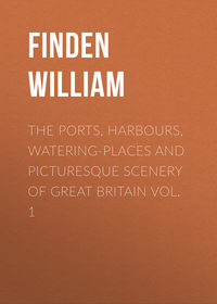
DOVER, FROM THE RAMSGATE ROAD
The most favourable point of view for an artist who is desirous of obtaining a general view of Dover, is certainly that portion of the Ramsgate Road of which Mr. Bartlett has availed himself on the present occasion. Placed at a sufficient elevation to enable him to embrace a wide extent of land and water, he is still sufficiently near the town to secure that distinctness of detail which adds so much to the effect of a landscape. One of the chief points of attraction in Dover must always be the Castle, but as we shall have another opportunity of referring to that structure, in connection with our view of Dover from the Beach, we purpose now to devote our attention to the town itself.
At the period of the Conquest, Dover was unquestionably a place of considerable note. It is mentioned, with Sandwich and Romney, in the Domesday-book, as a privileged port; and is said to have enjoyed, from an earlier period, sundry privileges and immunities in common with those two towns, on consideration of supplying a certain number of ships and mariners for the defence of the adjacent coast. In the reign of King John, Dover received a charter as one of the Cinque Ports; and in several succeeding reigns, its shipping and mariners were frequently employed in the fleets assembled to convey English armies to France. As it was considered the key of England, it was surrounded with walls and strongly fortified; and as it was the principal port in the kingdom for persons taking shipping in proceeding to France, acts were passed in the reign of Edward III. and Richard II., appointing the rate of passage. Henry VIII. expended large sums in the improvement of the harbour, the entrance of which had been much choked up by shingle washed in by the sea. A pier was commenced, and carried on at a great expense, but he died before it was completed; and in the reign of his successor, the work appears to have been almost wholly suspended. In the reign of Elizabeth, further attempts were made to improve the harbour; and in 1606 an act was passed appointing eleven commissioners, who were empowered to receive certain rates, and employ the money in repairing the pier and improving the harbour. In succeeding times various plans have been tried to prevent the increase of the bar, which, after a gale of wind from the seaward, is sometimes increased so much, as to prevent all vessels, except those that are of very light draught of water, from entering or leaving the port. It is high water at Dover pier at sixteen minutes past eleven on the full and change of the moon; and the rise of the water at spring-tides is about twenty feet. Dover is much frequented in summer as a watering-place; and for the convenience which it affords, and the beautiful and interesting scenery in its neighbourhood, it is surpassed by no other town on the coast.
At a short distance from the entrance to Dover Castle is mounted the long brass gun, usually called Queen Elizabeth's pocket-pistol, which was presented to her Majesty by the United Provinces. It is twenty-four feet long; but is so much "honey-combed," that, were it fired, it would be certain to burst. Popular tradition says that it contains an inscription to this effect: —
"Sponge me well, and keep me clean,And I'll throw a ball to Calais green."There is, indeed, an inscription on it in the Dutch language, but though it commemorates the destructive power of this long piece of ordnance, it says nothing which implies that its range was so extraordinary. The distance from Dover Castle to the church of Notre-Dame, at Calais, is rather more than twenty-six miles. This gun was cast at Utrecht in 1544, by James Tolkys, and the verses inscribed on its breech have been translated as follows: —
"O'er hill and dale I throw my ball;Breaker, my name, of mound and wall."About a mile to the southward of the town is the celebrated cliff which is supposed to have been described by Shakspeare in King Lear.
"Gloster.– Dost thou know Dover?Edgar.– Ay, master.Gloster.– There is a cliff, whose high and bending headLooks fearfully in the confined deep:Bring me to the very brim of it.* * * * *Edgar.– Come on, sir; here's the place: – standStill. – How fearfulAnd dizzy 'tis, to cast one's eye so low!The crows, and choughs, that wing the midway air,Show scarce so gross as beetles: halfway downHangs one that gathers samphire; dreadful trade!Methinks he seems no bigger than his head:The fishermen that walk upon the beachAppear like mice; and yon tall anchoring bark,Diminished to her cock; her cock, a buoyAlmost too small for sight: the murmuring surge,That on the unnumber'd idle pebbles chafes,Cannot be heard so high. I'll look no more,Lest my brain turn, and the deficient sightTopple down headlong."DOVER
Dover is in the county of Kent, and lies about seventy-two miles south-south-east of London. The town is situated in a valley, having on one side the cliffs on which Dover Castle is built, and on the other the eminence called the Heights; these are strongly fortified, and form the principal defence of the town and harbour. The greater part of the town lies on the western side of a small stream, called the Dour, which there discharges itself into the sea. The view in the Engraving is taken from the beach, on the eastern side of the harbour, looking towards the north-east. The row of houses seen extending in a line nearly parallel with the beach is called the Marine Parade; and, crowning the cliff, is perceived what of old was termed "the Key and Bar of England," – Dover Castle. Its importance as a place of defence against the attacks of an invading enemy has, however, been seldom proved; and for the last three centuries the best defence of England against the invasion of her foes has been her wooden-walls.
"Britannia needs no bulwark,No towers along the steep;Her march is o'er the mountain wave,Her home is on the deep.With thunders from her native oak,She quells the floods below,As they roar on the shore,When the stormy tempests blow;When the battle rages loud and long,And the stormy tempests blow."The height of the cliff, on which Dover Castle stands, is about three hundred and twenty feet above the level of the sea; and the area of the ground inclosed by the outward walls is about thirty-four acres. It has been supposed that the Romans, in one of Julius Cæsar's expeditions, first built a castle and established a military station at Dover; but this opinion is founded on mere conjecture, and is extremely improbable. That the Romans, at some subsequent period, had a station not far from the present keep is certain; for the remains of the walls and ditch are still perceptible. It however appears to have been but of small size, and was probably only a castrum exploratorum, or look-out station, garrisoned by a small body of soldiers detached from a neighbouring camp. Within the boundary of the exploratory camp the Romans had built a pharos, or watch-tower, the greater part of which is yet standing.
Previous to the Norman Conquest, there was undoubtedly a castle or fortress at Dover, probably near the spot where the keep or principal tower of Dover Castle now stands. Previous to the death of Edward the Confessor it appears to have belonged to Harold, afterwards King of England; for William, Duke of Normandy, who was then probably devising measures to secure to himself the English crown, refused to allow Harold to depart from Rouen, till he had taken an oath to deliver up to him "the Castle of Dover and the well of water in it," on the decease of Edward. After the battle of Hastings, the Conqueror marched without delay to Dover, took possession of the castle, and put the governor to death. It appears that he also burnt the town, which perhaps might not have received him with sufficient humility, in order to terrify others into immediate submission to his authority. The foundation of the present keep of Dover Castle was laid by Henry II. in 1153, the year before he succeeded to the English crown on the death of King Stephen. The ground plan is nearly a square, and the building, in its general appearance, bears a great resemblance to Rochester Castle, which was erected according to the designs of Bishop Gundulph – the architect of the White Tower in the Tower of London – in the early part of the reign of William Rufus. The walls of the keep of Dover Castle are from eighteen to twenty feet thick, and are traversed by galleries communicating with the principal apartments. The summit is embattled; and the top of the northern turret is 93 feet high from the ground, and about 465 feet above the level of the sea, at low water. The view from the top is extremely grand and interesting, including the North Foreland, Reculver Church, Ramsgate Pier, Sandwich, and a great part of the intermediate country, with the straits of Dover, the town of Calais, and the line of the French coast from Gravelines to Boulogne. In 1800, a bomb-proof arched roof was constructed, and several large cannon mounted on it. During the late war the fortifications were greatly strengthened, the old towers on the walls repaired, and additional quarters for soldiers constructed, in order that the garrison, in the event of invasion, might be able to withstand a regular siege.
SANDWICH, KENT
Her walls are crumbling down – the gate,Through which her merchants wont to pourIs all dismantled: adverse fateHas cast a blight upon her shore.Her streets and shipless haven showThe tenure of all things below.The history of Sandwich, as one of the Cinque Ports, presents a striking example of the fluctuation of trade, and the uncertain tenure by which all mercantile property is held, when supported by merely human ingenuity and enterprise. A very slight operation of nature is sufficient to paralyse the hand of ambition, and to strike the once productive landscape with sterility. Harbours, where our forefathers have counted the thickly crowded masts of stately merchantmen, are now deserted or forgotten. Many of the channels through which riches were once poured into this county, have been gradually dried up; while new ports and harbours have been opened on various parts of the coast, where commercial enterprise has fixed her abode. But, like their predecessors, these also may be deserted in their turn, and silently co-operate in that ever-progressive scheme of nature, by which, as the old and familiar scenes of our youth become changed or obliterated, others are called forth to take their place. The existence of a shoal, or the shifting of a sand-bank, may mar or diminish the prosperity of a city; and to the great local changes which this part of the Kentish coast has undergone, the decay of Sandwich, as a harbour, is chiefly to be ascribed. Where fleets of merchantmen once rode in safety; where the busy scenes of lading and unlading once offered pictures of maritime prosperity, the fishing-craft of the place can hardly find anchorage, and all the characteristics of a flourishing port have disappeared; so that it may be affirmed, with a truth too evident, that —
"The balance has shifted – prosperity's rayNo longer enlivens her harbour and bay."The town of Sandwich includes the parishes of St. Clement, St. Mary-the-Virgin, and St. Peter-the-Apostle. St. Clement's Church is a very ancient and spacious structure, with a massive tower, a noble specimen of the Norman style of ecclesiastical architecture. St. Mary's is also a church of considerable antiquity as well as St. Peter's; but both have been considerably damaged by time and accident. The Guildhall is an ancient and handsome edifice. The Free Grammar-School, endowed with exhibitions, was founded in 1563; and among the charitable institutions are the Hospitals of St. Thomas and St. John, in which a number of aged persons of good character, but in reduced circumstances, are comfortably supported. The Hospital of St. Bartholomew is a munificent foundation, from the funds of which sixteen decayed tradesmen of respectable character, and others, members of the corporation, are supported in comparative affluence.
Sandwich was originally enclosed by walls and partly fortified. It had eight gates, one of which, called Fisher's Gate, is considered by architects and antiquaries as well deserving of inspection, for the excellence of its design and workmanship. It illustrates a period when the craft had reached its zenith in this country, and when the Templars – the Vaubans of their day – still exercised the mysteries of architecture.
Ship-building and rope-making, as well as a foreign trade with Norway, Sweden, and Russia, in iron, timber, and hemp, are still carried on in Sandwich though comparatively to a very small extent. The home trade, chiefly with Wales and Scotland, consists of flour, seed, hops, malt, fruit, &c.; but of the once celebrated woollen trade of Sandwich not a vestige is left. The weekly market-days are Wednesday and Saturday, with a cattle-market every alternate Monday, and annual fairs on the second of October and fourth of December.
RAMSGATE, ENTRANCE TO THE HARBOUR
The view of the entrance to Ramsgate harbour, engraved from a painting by E. W. Cooke, is taken from the southward, and its fidelity will immediately be recognised by every one who has seen the place. It is blowing a stiff breeze, which causes a swell; and the fishing smack, seen entering, is lowering her sails, that she may not have too much way when she gets within the harbour. To the left is the lighthouse, which stands near the end of the western pier; and the extremity of the eastern pier is perceived to the right.
The cost of Ramsgate harbour, dock, lighthouse, and other requisite buildings, is said to have amounted to £650,000. The form of the harbour is nearly circular, and its area is about forty-six acres. The length of the eastern pier, following its angles, or "cants" as they are technically termed, is about 2000 feet, and that of the western about 1500. Their general width is about 26 feet, including the thickness of the parapets; and the width of the entrance to the harbour between their heads is 240 feet. The harbour is maintained by a tonnage duty on all ships passing, whether sailing on the east or west of the Goodwin Sands, and by a duty on coals and stones discharged in the harbour.
The light displayed from the lighthouse is stationary, and is only exhibited when there is ten feet water between the pier heads. In the day time a flag is hoisted while there is the same depth of water at the entrance of the harbour. In spring tides, the depth of water increases to sixteen feet in about an hour from the time that the ten-feet signal is displayed; in about two hours to twenty feet; and in three hours, or about high water, to twenty-one feet. In neap-tides the depth of water at those periods respectively is fourteen, seventeen, and eighteen feet between the pier heads.
During the summer, Ramsgate is much frequented by visitors from London, who come by the daily steam-packets to enjoy the benefit of sea-bathing, for which the beach to the southward of the pier affords excellent opportunity. Powerful steam-packets ply every day between London and Ramsgate, and the passage up or down is usually made in seven hours. There are several excellent hotels and many convenient lodging-houses at Ramsgate, and the charges generally are moderate. At the close of the year, when the summer visitants have all retired to their several homes, another description of persons make their appearance at Ramsgate – the Torbay fishermen, who generally establish their rendezvous there from December to June, for the sake of fishing in the North Sea. It seems probable that Ramsgate, as a port, will continue to increase very considerably in importance; and, in the event of a continental war, when steam-vessels are likely to be much employed, its eligibility as a place for the embarkation of troops, and as a packet station, will doubtless not be overlooked. It not unfrequently happens, in stormy weather, that the Dover packets enter Ramsgate with safety, when they cannot approach their own harbour.
The South-Eastern Railway Company have extended their line to Ramsgate, and the route, though rather circuitous, secures a large share of patronage from that portion of the pleasure-seeking visitants of our coasts to whom the stiff breezes and heavy swell, generally found off the North Foreland, are the reverse of gratifying.
George IV., on his departure to visit his Hanoverian dominions in 1821, embarked at Ramsgate; and to commemorate the event, an obelisk was erected by subscription of the inhabitants. The popularity of Ramsgate, as a watering-place, was greatly increased by the partiality evinced for it by her present Majesty, when Princess Victoria, who, with her august mother, the Duchess of Kent, honoured it with several successive visits.
Camden, in his Britannia, gives the people of the Isle of Thanet, and more particularly the inhabitants of Ramsgate, Margate, and Broadstairs, the following character: "They are, as it were, amphibious, seeking their living both by sea and land, and turning to account both elements. They are fishermen and ploughmen, farmers and sailors; and the same man that holds the shafts of a plough, turning up a furrow on land, can also take the helm at sea. According to the season, they make nets, catch cod, herring, mackerel, and other fish; go to sea, and export their own commodities – and those very men also dung the ground, plough, sow, harrow, reap, and house the corn." The inhabitants of Ramsgate, and of the Isle of Thanet generally, no longer retain this amphibious character; the "division of labour," the advantages of which are so strikingly pointed out by political economists in the manufacture of pins, has abridged their multifarious pursuits; the same man does not now till the earth and plough the sea; and few indeed are to be found who can handle an oar as well as a flail: the consequence is, that we have better boatmen and better agriculturists.
BROADSTAIRS. ISLE OF THANET
"True to the dream of fancy, Ocean hasHis darker tints; but where's the elementThat chequers not its usefulness to manWith casual terror?"Campbell.This delightful watering-place, nearly equidistant from Margate on the north, and Ramsgate on the south, enjoys its full share of popularity; and, judging from many recent improvements, offers increasing attractions to the numerous visitors who make Thanet's "sea-girt shore" their summer residence. To those who prefer tranquillity and retirement to scenes of bustle and holiday festivity, Broadstairs will present many advantages over its more gay and animated rivals; and to the studious and contemplative nothing can be more congenial than the society which generally meet once a year in this interesting spot. To the invalid it is favourable from the same causes, offering few temptations to gaiety or indulgence, but affording every facility for retired and intellectual enjoyment. The sea-view is magnificent; and the numerous vessels which are constantly passing and repassing give a most agreeable animation to the waters in front, which are walled in by lofty cliffs, from which the visitor inhales the fresh sea-breeze, as it first strikes the land, and carries its invigorating influence through his frame.
Broadstairs has long been the periodical residence of many distinguished literary men, most of whom have acknowledged the benefit derived from its bracing climate, and verified their opinion by repeated trials. If pure air could be as readily administered as certain medicinal compounds, there would be little necessity for so often deserting the courts and counting-houses of the metropolis in search of health; but so long as this "draught" cannot be made up according to nature's prescription, it is cheering to know that on the coast it may be had ready prepared, and without "mistake" or "adulteration."
It was while overlooking a scene like that which opens upon the visitor at Broadstairs, and while sensibly feeling all the salubrious influence of the breezes, that seemed to welcome and caress him when exchanging the pleasures of town for poetry and contemplation on the coast, that the Bard of Hope broke out into these noble and impassioned lines: —
"Hail to thy face and odours, glorious Sea!'Twere thanklessness in me to bless thee not,Great beauteous being! in whose breath and smileMy heart beats calmer, and my very mindInhales salubrious thoughts. How welcomerThy murmurs, than the murmurs of the world!Tho', like the world, thou fluctuatest, to meThy din is peace, thy restlessness repose.Even gladly I exchange yon spring-green lanes,With all the darling field-flowers in their prime,And gardens haunted by the nightingale'sLong trill, and gushing extasies of song,For these wild headlands and the sea-mew's clang!"Broadstairs appears, in addition to its attraction as bathing-quarters, to have formerly enjoyed a considerable share of trade in the fisheries; but this source of revenue having dried up, recourse was had to ship-building, which is still carried on to a small extent. Its chief dependence, however, is on the number and respectability of its visitors, many of whom retire here for several months annually with their families, and, by a liberal expenditure, do much to support the markets and to encourage local industry. The bathing-place is at the mouth of the harbour, under the cliff, and is provided with every accommodation to be found at the larger watering-places. There are two or more excellent hotels, and two extensive public libraries, commanding magnificent views of the sea and the shipping – from a fishing-boat to a seventy-four – passing to and from the Downs, at all hours of the day. The place is still further enlivened, as well as benefited, by the London steamers, which here land or embark passengers in their way to and from town.
KINGSGATE, NEAR BROADSTAIRS
"Olim Porta fui Patroni Bartholomæi,Nunc Regis jussu Regia Porta vocor,Hic exscenderunt Carolus Secundus RexEt Jacobus Dux Ebor. 30 Junii, 1683."So named in consequence of its having been the point at which King Charles II. and his brother, the Duke of York, disembarked on their way from London to Dover, as recorded in the preceding inscription. It consists of a narrow sloping passage, cut through the chalk cliff, and communicating with the beach for the convenience of the fishery formerly carried on in this neighbourhood. It was originally known as "St. Bartholomew's Gate," from the circumstance of its having been completed, according to tradition, on the festival of that Saint, and therefore placed under hallowed auspices. The eastern side of this portal, opposite the sea, bears, in Saxon characters, God Bless Barth'lem's Gate. It is about a mile from Broadstairs, and in the midst of scenery which Henry Lord Holland did much to embellish by great liberality and a correct taste in architecture. His marine residence here was built after the model of Cicero's villa on the shore of Baiæ, near Naples; but being subsequently purchased by some monied speculator, who had most likely never heard of Cicero, it was despoiled of its rich Italian marbles, curtailed and barbarised in its proportions, and metamorphosed into three insignificant dwellings. Around it were several fantastic buildings, intended to represent various Gothic ruins; the most considerable of which was the convent, containing the remains of a chapel and five cells, which once afforded an asylum to poor families. Nearer the cliff is a rude Gothic structure, erected on the larger of the two tumuli, called Hackendown Banks, which, according to tradition, marks the spot where a sanguinary conflict took place between the Saxons and the Danes, in which the latter were defeated. On opening these barrows, graves were found excavated in the solid chalk, of an oblong oval form, about three feet long, and covered with flat stones. In one of them were discovered three urns of coarse, black, ill-burnt earth, which, on being exposed to the air, crumbled to pieces. On a tablet erected by Lord Holland is a Latin inscription, to the memory of the Danes and Saxons, who here fought a sanguinary battle for the possession of Britain; the natives having before been perfidiously and cruelly expelled. The village of St. Peter, situated on a conspicuously wooded eminence, is much frequented by pleasure parties from the three bathing-places adjacent. The church is a fine, venerable structure, the steeple of which, of great strength and solidity, is remarkable for a rent from top to bottom, occasioned, it is said, by the shock of an earthquake, which was severely felt along this coast in 1580.