Полная версия
How to Draw a Map
Cosmas determinedly went on to discourage any consideration of Greek thought regarding the possibility of people inhabiting the Antipodean side of the spherical earth, for they ‘could not be of the race of Adam’. Did not the scriptures refer to the four corners of the earth? The Apostles were commanded to go out into the world and preach the Gospel to every creature; they could not reach the Antipodes and therefore such a place could not exist.
Now let’s take a look at the early medieval world as portrayed in Christian maps. I use the word ‘Christian’ very loosely, to describe a region and time, as in mapmaking cultures tended to overlap and influence each other. About 1,100 mappa mundi, or world maps, from this period are known to exist. The mappa mundi come in a number of groups, which include zonal maps, a group of diagrammatic maps that divide the world sphere into five climactic zones. Only two of these zones were believed to be inhabited: the northern temperate and the southern temperate, which were separated by an imaginary ocean along the equator.
Zonal maps attempted to fit landforms into the zonal concept, which emphasises the separating equatorial ocean and places north at the top, as we would view a world map today. They looked back to a Greek tradition where human existence was shaped by the natural world, and therefore it was believed that there was an unknown and inaccessible theoretical race occupying the southern temperate zone, which corresponded with the northern temperate zone. For the Christian mind this was an unresolved problem; this race was not mentioned in the Bible, so was it created by God?
Next (though in no particular order) are T-O (sometimes called the ‘Tripartite’) maps These offered a simplified description of geography, showing only the inhabited regions of the world as known to Roman and medieval scholars. The world map was illustrated within a circle, with the three land areas – Europe, Africa and Asia – divided by a T shape, representing water that reached out to a circular ocean. Most of these maps placed east (oriens in Latin) at the top, giving us the term ‘orienting’. These maps also resolved the problem of an unknown race by completely ignoring the possibility, at least geographically. Isidore, Archbishop of Seville (580–636 CE), used this style of map in his epic Etymologiae (‘Origins’), a collection of works from antiquity that would probably have been lost without his efforts.
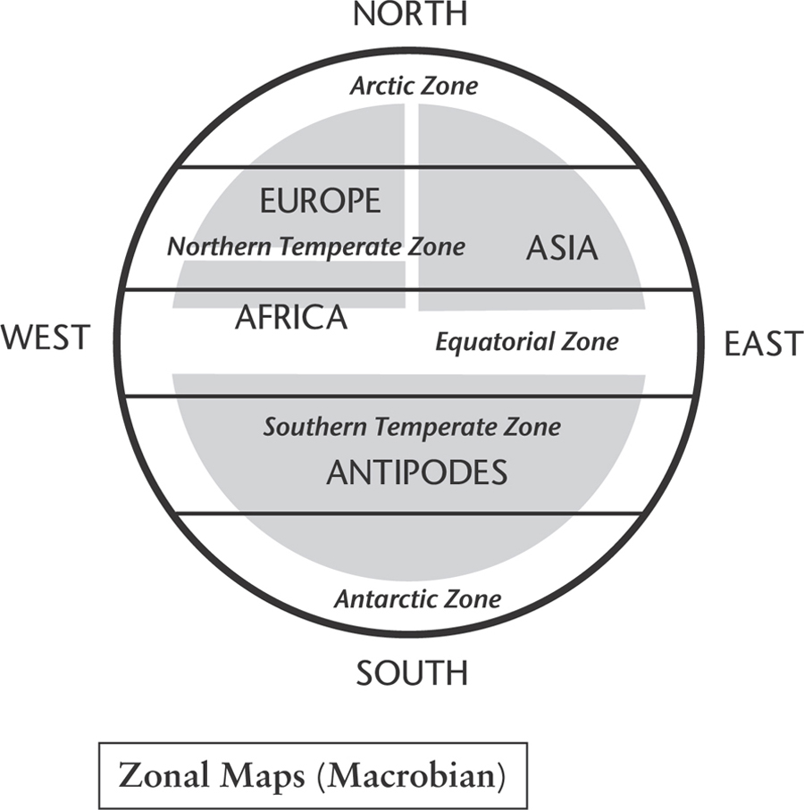
Map 11. These maps are sometimes called ‘Macrobian’, after the Roman administrator and author Ambrosius Aurelius Theodosius Macrobius.
In the maps known as Beatus, or Quadripartite, east is again shown at the top, where the Garden of Eden is located – a focal point of Christian belief. These maps show the three known continents plus a new and unknown continent to the south, hence the name Quadripartite. This fourth continent is often called Antipodes. The Beatus maps are named after Beatus of Liébana, a monk and theologian with a keen interest in geology. In the years running up to his birth in around 730 CE the bulk of Visigothic Spain had been overrun by Muslim invaders of the Umayyad dynasty, with the exception of the kingdoms of north-west Spain, the home of Beatus. The most accurate mapmakers of the day were Arabic, and their maps would have influenced the young monk, who is now best remembered for his work Commentary on the Apocalypse of St John, published in 776 with revisions in 784 and 786. The Beatus maps that now exist are believed to derive from an original now lost to us.
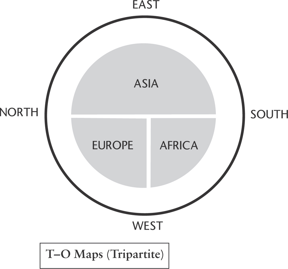
Map 12. These maps illustrated only the habitable portion of the world, as it was known in Roman and medieval times.
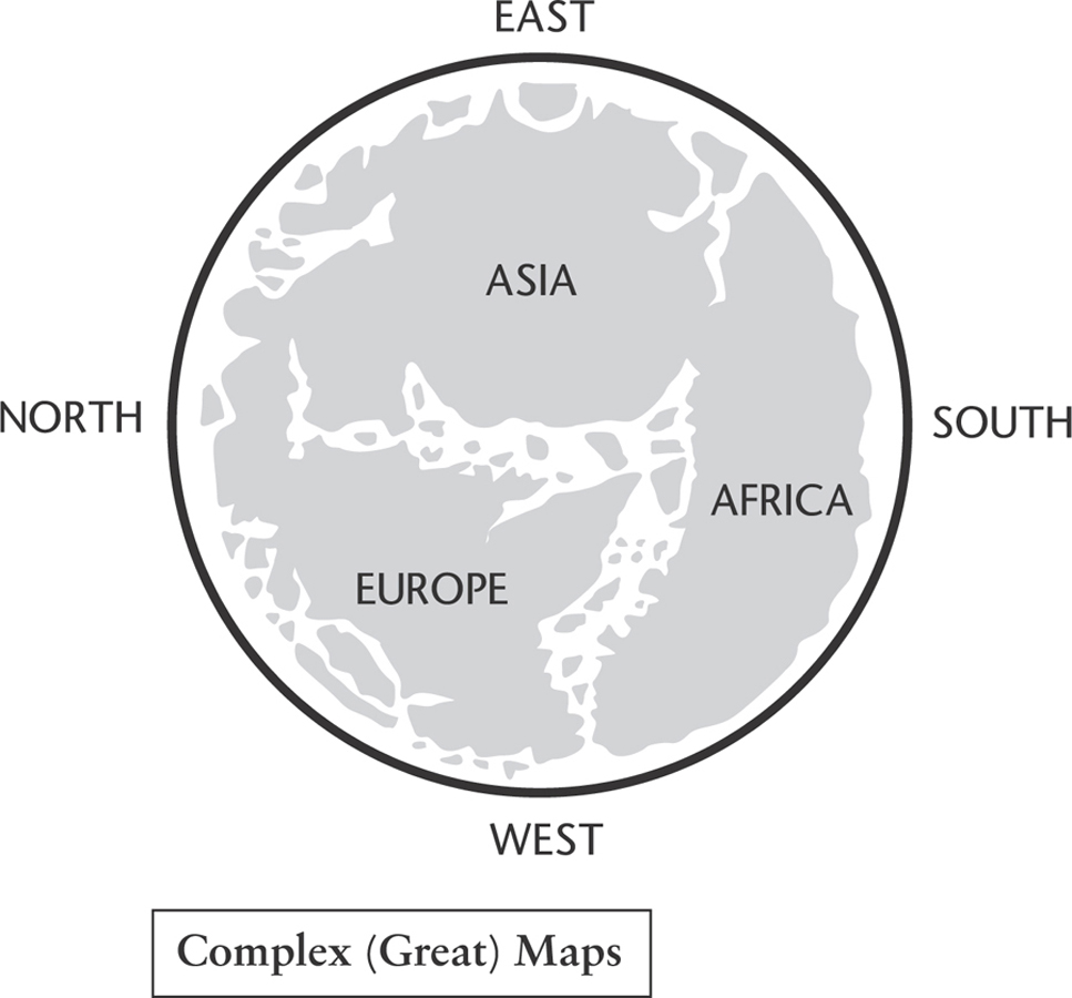
The Complex, or Great, maps are perhaps the most famous manifestations of the mappa mundi world maps. The Ebstorf map, made by Gervase of Ebstorf following the T-0 format in the 12th century, was rediscovered in a convent in Ebstorf in 1843. It was painted on 30 goatskins and showed detailed landforms with illustrations from classical antiquity, as well as images from biblical history. The head of Christ is shown at the top – the east – of the map. The original was lost in an allied bombing raid in 1943, but a number of copies still survive.
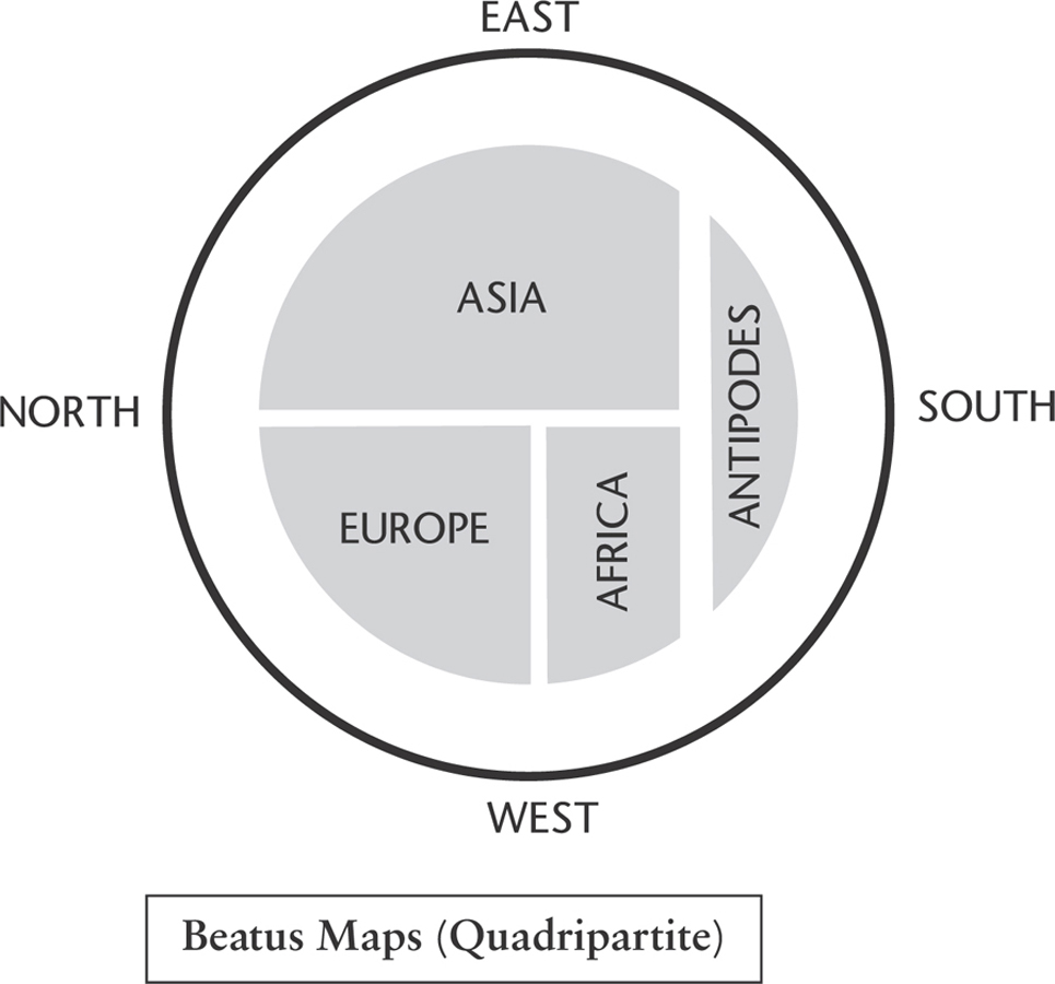
Map 13. These maps represent a kind of amalgam of Zonal and T–O maps and include a fourth, unknown continent, sometimes labelled ‘Antipodes’.
The largest map of this style known to still exist is the Hereford mappa mundi, created around 1300. It is drawn and painted on a single sheet of vellum, 158cm by 133cm, and illustrates fifteen biblical events, five scenes from classical mythology, 420 towns and cities, plus people, plants and animals. Again, east is at the top, with Jerusalem in the centre and the Garden of Eden towards the edge. The map was displayed on the wall of a choir aisle in Hereford Cathedral but was apparently little regarded. In times of trouble – during the Civil War and the Commonwealth in the 17th century, for example – it was hidden beneath the floor of the chantry. During the Second World War the map was hidden again, before being returned to the cathedral in 1946.
A new library to house the map was built with public subscription and large donations from the National Heritage Fund and Paul Getty, which was opened in 1996.*
Despite the cultural revision encouraged by the Christian faith, some classical works still survived across the empire of Charlemagne, which extended across northern and western Europe in the 8th and 9th centuries. Meanwhile, in the Islamic world, a huge amount of classical learning and geography had been preserved by scholars from Baghdad to Córdoba. I call this the Islamic tradition in geography, but it is a very loose description; there was a degree of learning and exchange between this tradition and neighbouring ones; for instance, the Christian tradition and, to a lesser degree, Indian tradition to the east. Al-Mas’udi was a fine proponent of Islamic cartography.
Map 14. These maps show coastal details, mountains, rivers and cities, and may sometimes include figures and stories from history and the Bible.
Al-Mas’udi (896–956 CE), referred to by some as the Arabic Herodotus, was born in 896 CE in Baghdad, descended from Abdullah Ibn Mas’ud, a companion of the Prophet Muhammad. His education took place in and around Baghdad and Basra, learning from well-known and much-admired local literary scholars. He was also influenced by the Mu’tazila school of Islamic theology, which taught that good and evil were not determined by interpretations of revealed scripture, but could be established through ‘unaided reason’, because knowledge was derived from reason, the final arbiter in distinguishing right from wrong.
Al-Mas’udi was thus well equipped to describe and interpret the world he observed in the mid-900s CE and we owe much to the detailed observations he left us as he travelled around the Near East and Persia, North Africa, the Arabian Sea and further afield to the East African coast and to India and Sri Lanka. He took an interest in European affairs and studied the political goings on in Byzantium in particular. In his writings on the latter, in and around the year 947 CE, he uses the name ‘Istanbul’, rather than the usual Constantinople, five centuries before the Ottoman conquest of the city. He was aware of faraway Anglo-Saxon England and the Frankish kingdom with its capital at Paris, listing their kings up to his own time.
Travelling far to the north, he describes the Rus, an account based on personal experience and contacts made on his explorations. He describes the diverse nature of the Rus and the apparent absence of a central authority, with power in the hands of a collection of local rulers instead; they were, as he notes, capable sailors, navigating both their extensive river systems and the open sea. He was well aware that the Black Sea and the Caspian Sea were separate bodies of water, as you can see on his world map.
East of the Rus were the lands of the Kazars, a Khanate made up of a Turkic ruling elite and other diverse ethnic groups who followed various religious traditions. According to Al-Mas’udi, the Kazar rulers converted to Judaism sometime in the 740s CE and encouraged the population to follow their example; what success they had still seems open to debate among today’s scholars.
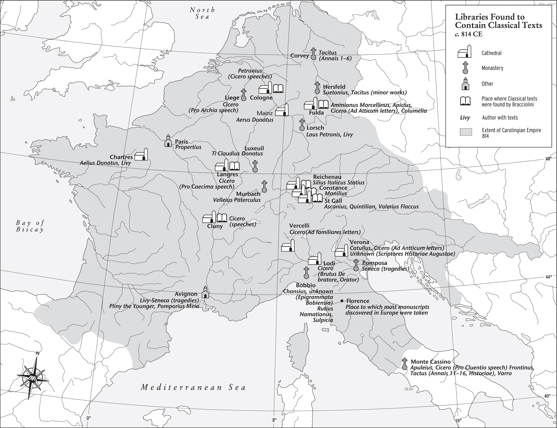
Map 15. Some classical texts survived within the Carolingian Empire and many surviving texts were taken to the city of Florence.
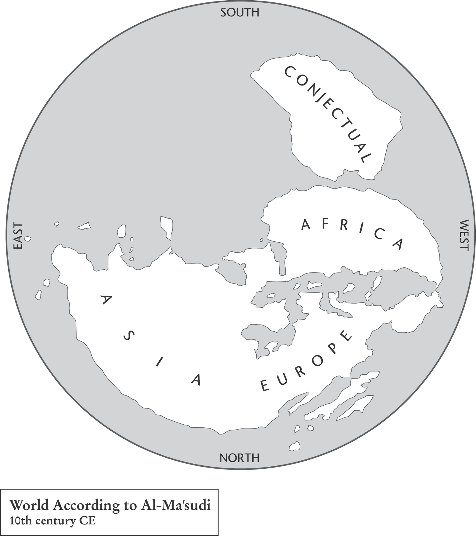
Map 16. Al-Mas’udi was an Arab historian, geographer and explorer. His world map, which followed Arab tradition at the time, viewed the world with south at the top.
Al-Mas’udi went on to describe the Turkic tribes of Central Asia and wrote in some detail on India, its rulers, trade and beliefs. He described China, though in less detail, dwelling at one point on a revolt towards the end of the Tang period, led by a certain Huang Chao, which he describes as leading to a weakening of the dynasty.
Al-Mas’udi was a prolific writer, but the best known of his works is Muruj adh-dhahab wa ma’adin al-jawahir (‘Meadows of Gold and Mines of Gems’), a history that begins with Adam and Eve and takes the reader through the ages to the time of the late Abbasid Caliphate. The same book mentions the story of Khashkhash Ibn Saeed Ibn Aswad, a navigator of al-Andalus (in southern Spain) who sailed across the Atlantic in 889 CE and eventually returned loaded with booty. This story is said to be well known among the people of al-Andalus – a tantalising tradition for succeeding generations of Iberians staring towards that vast western horizon.
He was an expert mineralogist and geologist, proposing a theory of evolution based on his observation of fossils; thus – from minerals to plants to animals to man – his work preceded Darwin by 900 years.
* The map, the cathedral and the town are all well worth a visit. Hereford is also the birthplace of 17th-century actress and Charles II’s mistress Nell Gwynn. I enjoyed a very happy couple of days there, lubricated by good cider.
* * *
I try to spend as much time as I can these days in my little place in Normandy, in the middle of the Cotentin Peninsula – a great place to rest and recuperate. It is an ancient small farm, and the building is long and thin, 25 feet wide and 105 feet long. It is about half a mile from a small village, and Axel, an old and very knowledgeable local worthy, visits from time to time – just to test my wine stock, you understand, and offer advice on anything he might notice. Like most Normans, he is very generous in that way, and I soon come to realise that the shelf I have just put up in the kitchen is in the wrong place. The Normans are an unusual group of people, an amalgam of long-settled farming folk with layers of Franks and later Vikings, the latter in particular. My neighbours, Axel included, lay specific claim to being of Viking descent – an important element of their family inheritance. In Axel’s case, with a face of sun-bleached leather, white bristly hair and bright, clear blue eyes, he might just be right.
Not far from the farm lie the ancestral lands of the Hauteville dynasty. This particular Norman family arrived in southern Italy in 999 CE as mercenaries on behalf of Byzantine and Lombard overlords, and it did not take long for them to see the opportunities the area presented. On hearing the good news, more Normans, well armed and upwardly mobile, were soon on the way, eager to carve out estates for themselves. Unlike the conquest of England, which took less than a decade to consolidate, in Italy and Sicily the process took over 100 years. Eventually the Normans became local lords, and then ‘the power’ in the land.
King Roger II inherited his Italian and Sicilian domains from his father Roger Guiscard, Roger I, Count of Sicily, and in 1130, he established the Kingdom of Sicily. For 24 years he ruled over an unusually diverse state, made up of native Sicilians and south Italians, Arabs, Lombards, Byzantines and Normans, and fought a complicated struggle to control his lands, but in doing so he developed an amazingly inclusive and tolerant society.
Among the citizens of this realm was a certain Abu Abdallah Muhammad Ibn Muhammad Ibn Abdallah Idris al-Sharif al-Idrisi, a name that rolls off the tongue, but let’s call him al-Idrisi for short. Al-Idrisi spent much of his time in the Christian kingdom of Sicily, and consequently the geographic traditions of Islam and Christianity came together in his work. He was born in the North African city of Ceuta, spent part of his early life in al-Andalus and travelled through France and into England, stopping in London and York. I was in York not so long ago, and with an afternoon to spare I walked around the area of the minster and pondered the fact that one of my cartographic heroes had, at least according to some, visited the city. With this thought on my mind I wandered into a fine little place with good beer called The Hole in the Wall, and chose the special of the day, a hearty plateful. It seemed an ancient place located on a medieval plot. What, I wondered, had al-Idrisi chosen from the menu 885 years earlier? What was the special of the day in 1130? He would have seen Normans strutting through the lanes, as they had conquered the place 60 or so years before. His later journeys took him east to Anatolia and North Africa, where he gained first-hand knowledge of those regions. Al-Idrisi chose to settle in Sicily in around 1136 and his skills eventually came to the attention of the royal household. Roger II’s administration was run by a royal chancery, and among its talented staff were Greek, Arabic and Latin scribes who were capable of producing documents to suit the needs of his state and its population, in whatever appropriate language might be needed.
Around 1144, Roger commissioned al-Idrisi to produce what we might now call an atlas. King Roger II had a keen interest in the extent of his domains, which are shown at their maximum reach, in around 1150, drawn in the dark tint on our rendition of al-Idrisi’s world map. In Arabic the work was called Kitāb nuzhat al-mushtāq fī ikhtirāq al-āfāq or ‘Entertainment for He Who Longs to Travel the World’. Al-Idrisi had produced a collection of 70 detailed maps covering the known world, their orientation with south at the top. (If you look at al-Idrisi’s work on the internet, his maps are frequently upside down, with north at the top, to help the modern viewer.) The atlas became known as The Book of Roger, indicating the king’s important role in sponsoring the work. It was created following the Greek tradition, dividing the world into seven climes and moving from west to east, describing each clime in detail. Al-Idrisi referred extensively to previous Arabic geographers in his final compilation. He also relied on his own observations as well as collating the reports of contemporary travellers, many of whom, as you might expect, passed through the ports and towns of Roger’s kingdom, located as it was in the central Mediterranean. The work’s geographical accuracy, an improvement on Ptolemy’s gigantic contribution, corrected the interpretation of the Indian Ocean as enclosed by land and the form of the Caspian Sea, and determined the direction of major European rivers. Further details were added concerning China and Tibet far in the east. In Africa, the lakes near the Mountains of the Moon are shown as the source of the Nile, whose course is tracked to the Mediterranean. The Niger River is also shown, locating the trading city of Timbuktu on the edge of the known world.
The map’s style and draughtsmanship and the choice of colour are a joy to behold. They have a kind of rhythmic quality; to my eye there is a modern feel – perhaps David Hockney’s pool paintings are suggested. I could stare at them for hours. Among all the triumphs of cartographic design, a calculating mind was at work on this map, as al-Idrisi estimated the circumference of the earth to be some 22,900 miles, which was just 8 per cent off from a modern calculation.
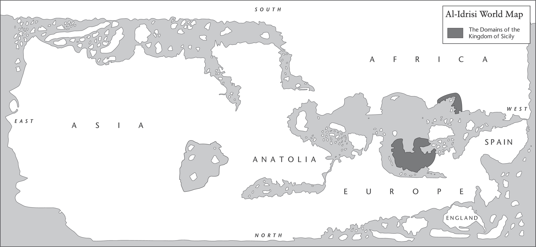
Map 17. Muhammad al-Idrisi was a geographer and cartographer. For much of his life he lived in Palermo, Sicily, at the court of King Roger II.
Al-Idrisi’s work remained a standard for accuracy for almost 300 years after it was written. Geographers and travellers from Islamic traditions, such as Ibn Battuta, Ibn Khaldun and Piri Reis, were influenced by it in creating their own views of the world, while European explorers such as Vasco da Gama and Christopher Columbus also read his work in detail, thus shaping Christian tradition also.
Конец ознакомительного фрагмента.
Текст предоставлен ООО «ЛитРес».
Прочитайте эту книгу целиком, купив полную легальную версию на ЛитРес.
Безопасно оплатить книгу можно банковской картой Visa, MasterCard, Maestro, со счета мобильного телефона, с платежного терминала, в салоне МТС или Связной, через PayPal, WebMoney, Яндекс.Деньги, QIWI Кошелек, бонусными картами или другим удобным Вам способом.