Полная версия
The Isles of Scilly
The next headland round the coast is Peninnis Head, the southernmost point on St Mary’s (Fig. 33). This rocky promontory is important, with habitats that support rare plants and lichens. The impressive weathering of the granite tors and the lack of glacial features also contribute to the geological significance of the site. In the nineteenth century Peninnis ‘was considered one of the pleasantest places on the island by visitors; it was a large open downs with no hedge on the west side of it until you got halfway to Buzza Hill, and it was covered with long heath and wild flowers of various kinds which made it very pleasant in summer time’ (Maybee, 1883). The headland is still popular with visitors, who enjoy the dramatic scenery of massive granite carns eroded into natural sculptures and, among the rocks and tumbled boulders, the squat little lighthouse on the Head overlooking St Mary’s Sound. This is the place where the islanders have lit ceremonial bonfires in the past, and it was also the site for the Millennium beacon on 1 January 2000. There are the usual stretches of coastal grassland and maritime heath over the granite, with western clover Trifolium occidentale and two species uncommon elsewhere, spring squill Scilla verna and wild thyme Thymus polytrichus at one of its few Scilly locations. The most exposed edge of the headland is noted for its rare lichen flora including Ramelina siliquosa, Roccella fuciformis, R. phycopsis, golden hair-lichen Teloschistes flavicans and ciliate strap-lichen. To reach the Peninnis headland there is either the track around the coast or the central track from Hugh Town, King Edward’s Road, bisecting the cultivated centre of the headland, with arable fields and pastureland either side. The soils here are deep and less sandy than elsewhere
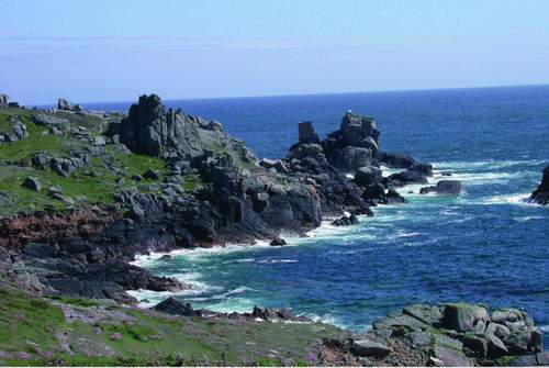
FIG 33. Peninnis Head is a jumble of extraordinary granite tors. May 2005. (Rosemary Parslow)
so a different range of arable weed species is found among the crop: these include some of the goosefoots Chenopodium spp. as well as the ubiquitous corn marigold Chrysanthemum segetum, docks Rumex spp., shepherd’s-purse Capsella bursa-pastoris and sow-thistles Sonchus spp.
Above Hugh Town is the high, rocky promontory of the Hugh, almost completely surrounded by the granite walls of the early fortifications of the Garrison. Here the long history of the Garrison is marked by an array of buildings, defence works and other structures. English Heritage manages most of the historic buildings and walls that form the Ancient Monument. There are some areas of semi-natural vegetation within the fortifications managed by the Wildlife Trust, mainly areas of bracken and bramble thickets, rough heathland and mown grassland. Some of the windbreaks of Monterey pine have died but there are still more pines and other trees on the eastern flank of the promontory. On the slopes of the hill Babington’s leek and balm-leaved figwort both grow among the bracken and bramble. And a few stands of the Nationally Scarce wild leek Allium ampeloprasum can also be found here, probably overlooked because they were assumed to be the commoner Babington’s leek variety. On the exposed southern side of the Garrison there are more maritime habitats from below the walls to the rocky shore (Fig. 34). There is also a row of tiny abandoned gardens perched on the edge of the cliffs. The thin soils on top of the massive granite walls often support a therophyte community (therophyte plants overwinter as seeds and germinate in spring) of dwarfed species of grasses and forbs similar to that seen on natural granite outcrops around the coast. Where they are permitted to flourish, small ferns such as sea spleenwort lodge in the mortar between the granite blocks, as do other plants that are usually found in rock crevices on the cliffs: Danish scurvygrass Cochlearia danica, pearlworts Sagina spp. and thrift Armeria maritima are frequent examples.
Other interesting species of ferns and other plants grow on both sides of the high granite walls. Between the ramparts are mown lawns that in some places are still typical of coastal grasslands with a tight sward of fescues Festuca spp., buck’s-horn plantain Plantago coronopus, sheep’s sorrel Rumex acetosella, small-flowered catchfly Silene gallica, western clover, rough clover Trifolium scabrum and other clovers. Besides the usual resident birds, the coastal area and the shelterbelts are good venues at bird migration times to look out for species such as wheatear, wryneck Jynx torquilla and black redstart Phoenicurus ochrurus. One section of wall near the Woolpack Battery is remarkable for the hundreds of autumn lady’s-tresses orchids Spiranthes spiralis that flourish there just at eye level in late summer.
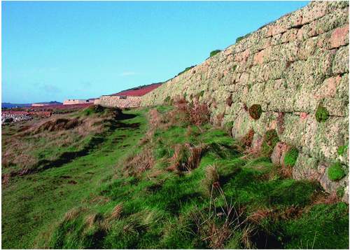
FIG 34. Exposure to southern gales restricts growth on the seaward side of the Garrison walls to lichens, tiny ferns and a few other plants. November 2002. (Rosemary Parslow)
QUARRIES
There are a number of former quarries on St Mary’s. Most are overgrown or incorporated into fields, and many are unlikely to be noticed. One you cannot miss is on the side of Buzza Hill. Rising up from Porth Cressa beach, the hill is a popular vantage point to look out over the town and beach below. The quarry at the foot of the hill is mainly used as an informal picnic or rest area and has a mixture of scrub and rough vegetation as well as grassland in the base. Among the plants that have colonised the walls of the quarry are Hottontot fig and another South African succulent, lesser sea-fig Erepsia heteropetala. Another unusual alien grass, rough dog’s-tail grass Cynosurus echinatus, also grows all along the sides of the track up the hill, usually with greater quaking-grass Briza maxima and tall stands of yellow and occasionally white sea radish Raphanus raphanistrum maritimus. Further up the hill yet another unusual alien called wireplant Muehlenbeckia complexa scrambles over the walls, covering most of the vegetation and even the ground with dense wirelike growths so it becomes a kind of mad sculpture. Once at the top of the hill you reach Buzza Tower (a former windmill restored to commemorate a visit by King Edward VII), surrounded by scrub, tall grasses and herbs. The shrubs include broom (probably native here) as well as gorse and bramble.
At the top of Buzza Hill you will find you are on the edge of Hugh Town again and there are many houses, some of which are guesthouses. Inland at Carreg Dhu (pronounced, and sometimes written, as Crake Dew) is another former quarry. This has now been developed as a garden open to the public (see Chapter 13). There is also the former quarry on the Garrison, which has now vegetated over and is probably generally passed unobserved. Other small quarries exist all around the island, and may have just been used very locally to produce building stone or ram.
PORTHS AND BAYS
Because part of St Mary’s straddles a sand bar there are two bays with sandy beaches, Porth Cressa on the south and Town Beach on the north within the Pool (harbour). Porth Cressa lies between the two headlands of Peninnis, the long promontory stretching to the south, and the Hugh, the hill surmounted by the Garrison with the town creeping up its flanks. Porth Cressa is one of the most accessible and popular bays with families and visitors staying locally, because of its proximity to the town and local amenities (Fig. 35). Although it is usually a sheltered bay, the area has proved extremely vulnerable when there are storms from the south. In the past the sea has broken through on a number of occasions and threatened to wash away the buildings (which are virtually only perched on the former sand dune) and eventually cut through into the Pool on the other side of the island. In recent years major defence works have been carried out along Porth Cressa beach to reinforce the sea bank and protect the town. There is perhaps little of great interest yet along the beach, due to the landscaping when the bank was restored, although arable weeds are reappearing in the flowerbeds and some of the sand-dune plants such as sea radish and yellow horned-poppy Glaucium flavum are colonising the beach defences. Town Beach has slightly more muddy sand, and is where all the mooring lines from the smaller boats in the harbour are stretched ashore.
There are several bays on the east coast of St Mary’s. Old Town Bay is quite rocky but with clear channels into the harbour, sheltered from all directions except southeast. The harbour is only accessible at high tide. Near the narrow sandy beach are patches of tree-mallow Lavatera arborea, smaller tree-mallow L. cretica, sea radish, white ramping-fumitory Fumaria capreolata and other plants
FIG 35. Porth Cressa, July 2006. (Rosemary Parslow)
that flourish in the disturbed sandy ground. The sea wall was rebuilt in 1996 after severe storms caused a great amount of damage.
Porth Minick is quite a small bay and has also had substantial sea defence works to reinforce the sea bank. One of the best stands of sea-kale Crambe maritima grows at the top of the beach, and I once saw an islander collecting leaves of the plants by the sack-load – whether to use as a vegetable or perhaps more likely to feed tame rabbits was not clear. Among the rocks at one end of the beach are clumps of house holly-fern Cyrtomium falcata growing in deep crevices where it has been established for many years among the boulders. Fortunately the beach works stopped just before reaching the fern.
Porth Hellick is a large inlet at the seaward end of the Higher Moors nature trail. There is a narrow sandy beach and below it a rocky bay with pools and shallows that attract many birds; at times rare waders will turn up to feed at low water. Between the reedbed around Porth Hellick Pool and the bay there is a narrow strip of tall grassland with wild angelica Angelica sylvestris, balm-leaved figwort and bracken. The bank of the Porth is densely planted with clumps of spiky rhodostachys Fascicularia bicolor, replacing the New Zealand flax Phormium sp. that formerly grew there to consolidate the low dune. The seaward side of the bank supports common dune plants, marram Ammophila arenaria, sea sandwort Honckenya peploides, sea-kale, yellow horned-poppy and oraches Atriplex spp. This is also a good place to look for the distinctive little striped nymphs of the lesser cockroach Ectobius panzeri. Greek sea-spurrey Spergularia bocconii used to grow near the small granite monument to Sir Cloudesley Shovell at the top of the beach, although it has not been seen there for many years, possibly due to the changes that have been made to the sea bank (recently Greek sea-spurrey has been re-found at other sites on the east coast of St Mary’s). The monument marks the spot where the ill-fated admiral’s body was first buried (it is now in Westminster Abbey) when it came ashore after his fleet foundered in the islands in 1707. Another very beautiful sandy bay on the east side of the island is at Pelistry, with its sparkling white sands and unsurpassed views towards Toll’s Island and a distant view of the Eastern Isles.
There are also sandy bays on the west coast of St Mary’s. Porth Mellon is on the edge of Hugh Town and popular for sailing and other activities. There is a degraded sand dune at the back of the bay with some typical species among the marram grass. The next small sandy bay is Thomas’s Porth, backed by narrow dunes and dune grassland. A little group of small bulb fields above the bay once
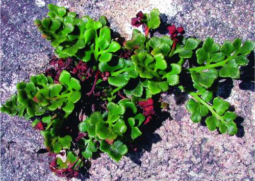
FIG 36. The coastal form of wall rue, with unusually thick and fleshy fronds. St Mary’s, June 2004. (Rosemary Parslow)
grew a crop of the original Sol d’Or narcissus. Among interesting arable species in these fields are fumitories Fumaria spp., small-flowered catchfly and masses of starflowers Tristagma uniflorum. One of the less common Carpobrotus species grows beside the footpath and Babington’s leek grows in the dunes. At Porthloo the grassland behind the dunes is used for boat standing and boat building; occasionally plants such as hairy buttercup Ranunculus sardous and arable weed species can turn up here due to the constant traffic and disturbance. Wall rue Asplenium ruta-muraria grows on a wall near here, the only place the fern is known on St Mary’s (Fig. 36). The fronds are unusually thick and fleshy, probably due to exposure to salt spray. Porthloo is also a geological SSSI, based on the Quaternary sedimentary deposits in the cliffs, the raised beaches, and organic material that includes pollen indicating former arctic tundra conditions in the palaeoclimate of the island.
WETLANDS
On St Mary’s there are two large wetland nature reserves, Higher Moors and Lower Moors. Higher Moors is fed by a stream that arises in Holy Vale and flows down through the Holy Vale nature trail through the tangle of tall elm trees, grey sallow and understorey of wetland plants either side of the raised pathway. The stream continues through an area of rank grassland and yellow iris. In the stream grow tall plants of fool’s-water-cress, water-cress Rorhippa nasturtium-aquaticum and hemlock water-dropwort. Higher Moors nature reserve and SSSI include both the ‘moor’ and Porth Hellick Pool. Access to the reserve is via a path leading from the road to the coast. Within the reserve views can be made from the boardwalk through the reedbed and from two bird hides overlooking the pool. Along the path a line of very large tussock-sedge Carex paniculata plants usually attract attention as they are up to a metre and a half high and have ferns and other plants growing epiphytically on their trunks. It seems quite shocking now to realise that at one time attempts were made to destroy the plants by killing them with herbicide and burning them. Fortunately, in more enlightened times, clearance of vegetation from around the sedges and cutting back the willow carr has encouraged them to spread. There are also some magnificent stands of royal fern as well as the ubiquitous lady fern Athyrium filix-femina throughout the site.
The Lower Moors nature reserve is situated in a low-lying area between Hugh Town and Old Town Bay (Fig. 37). A stream flows through the site to the sea at Old Town. Part of the area is reedbed, part marsh composed of beds of a very lax local variety of sea rush Juncus maritimus (the endemic var. atlanticus, according to
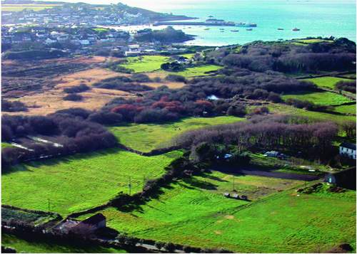
FIG 37. Lower Moors from the air, February 2004. (Rosemary Parslow)
Lousley), and there are areas of grey sallow carr, as well as a small pool and a scrape with bird hides on the bank. The pools and surrounding vegetation attract rare birds in the migration season. There are ditches, wetter areas and more open areas, all of which support a range of typical wetland plants.
There are also a few other small freshwater pools on St Mary’s, although several have generally degenerated into duck ponds. There is a pond beside the road from Porthloo to Rose Hill which, with the two fields on the west and Well Field on the east, is managed by the Isles of Scilly Wildlife Trust as a nature reserve. These fields are composed of a mixture of wetland plants and open grassland. Very little of nature conservation interest remains in the duck pond these days; it has largely been given over to a collection of exotic ducks and a few half-tame moorhens Gallinula chloropus.
Two small freshwater pools at Newford, the Argy Moor pools, drain into the Watermill Stream. Originally designed as ponds as part of a failed attempt to grow flax (presumably the ponds would have been used to steep the plants), the ponds are now very eutrophic due to the large numbers of semi-domestic ducks that frequent the site. There are a number of introduced plants around the ponds and a few marginal species such as soft rush, but there now (2006) appear to be no aquatic plants, although prior to the invasion of water fern Azolla filiculoides there had been a typical aquatic flora (Lousley, 1971). Whether it was the strenuous attempts to get rid of the water fern using herbicides that also eliminated all the aquatic plants, or whether the conditions of the ponds are no longer suitable, is unclear.
Shooter’s Pool, a small pool on farmland behind Lower Moors, is being developed to provide freshwater habitats for birds by the Isles of Scilly Bird Group (in 2005 the pool attracted a black-winged stilt Himantopus himantopus). This pool at one time had a population of the rare lesser water plantain, but this apparently disappeared some years ago. It will be interesting to see whether the plant reappears in future.
CHAPTER 6 The Off-Islands
We’ll rant and roar, across the salt seas
Soon we’ll strike soundings in the Channel of Old England
From Ushant to Scilly is thirty-four leagues.
Spanish Ladies, traditional sea-shanty
IN ADDITION TO St Mary’s there are four inhabited islands in the Isles of Scilly. These are called the ‘off-islands’ by Scillonians. Three were formerly joined to St Mary’s when Scilly was mainly one large island many centuries ago (see Chapter 2). St Agnes has been separated from the rest far longer by a deep channel, St Mary’s Sound, and as a result always seems to have a different ‘feel’ and some differences in the flora that may reflect this longer isolation. None of the off-islands has a large population. The majority of the inhabitants are farmers with some involvement with the sea, boats or fishing, and most rely to some extent on tourism.
BRYHER
Lying just to the west of Tresco is the island of Bryher. The island is only 129 hectares above MHWS, 2km long by 1km wide. Even so, the topography is very varied. At the far northernmost tip is the domed headland of Shipman Head Down, 42 metres high and divided from the extreme rocky promontory of Shipman Head by a narrow channel through which the sea boils at high tide. The bay to the west of Shipman Head Down, Hell Bay, is famed for its restless, dramatic seas (Fig. 38). Dominating the west coast of the island are Gweal Hill
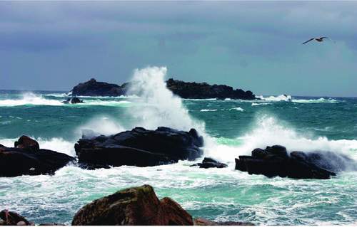
FIG 38. Restless sea in Hell Bay, Bryher, May 2006. (Richard Green)
and Heathy Hill, with bays between, Great Popplestone Bay, Stinking Porth and Great Porth. These end in Stony Porth and the sandy bay and dunes of Rushy Bay in the south of the island, looking across to the island of Samson. The eastern side of Bryher is more sheltered and sandy, with dunes facing Tresco across the shallow channel. Only beyond the post office in the northeast does the coast become rocky, with a rather sinister small rocky islet topped with a gibbet emerging from the sea: this is Hangman’s Island, where apparently Admiral Blake, who put down the Royalist uprising in 1651, hanged some of his men (Vyvyan, 1950). Watch Hill gives a good vantage point for looking out over the island, as does Samson Hill further to the south.
The centre of Bryher is low-lying, mainly arable fields and pastureland. The gardens and grounds associated with the hotel occupy a large site dominating the lower land in this part of the island. Close beside the hotel is Great Pool, a large brackish pool with a fringe of marshy vegetation. Most people visiting Bryher for the first time will either head south to the beach at Rushy Bay, a ‘must’ for naturalists because of the unusual plants that are found there, or will aim for Shipman Head across the top of Shipman Head Down to see the notorious wild seascapes in Hell Bay.
Bryher has many good things to offer, and you do not have to be a naturalist to appreciate the colour and the beauty of the scenery. The island is small enough to get round in a day, although it repays a longer visit. Although Bryher does not have the wealth of bulb-field annuals of other islands it does have some, for example common fumitory Fumaria officinale, which is very uncommon elsewhere in Scilly. The dune grassland behind Rushy Bay supports a great variety of dune species, usually in a very stunted form. There are miniature plants of sea spurge Euphorbia paralias and Portland spurge, common stork’s-bill Erodium cicutarium, forget-me-nots Myosotis spp. and English stonecrop Sedum anglicum, growing virtually in pure sand. Nothing, however, can quite prepare you for the Lilliputian perfection of the rare dwarf pansy, when you eventually find it, growing in the sandy turf and on bare sand. In May the pansy may be in its thousands, but they are often very difficult to find. In the dunes behind the bay there is a population of grey bush-crickets Platycleis albopunctata that live mostly in among the marram grass. The very observant may also find one of the tiny lesser cockroaches scuttling across the sand behind the dunes.
Perhaps the next attraction for the naturalist is the Great Pool and surrounding marshy vegetation (Fig. 39). The pool lies close to the shore at Great Porth and is unique in now being the only true brackish lagoon in Scilly. A leat links the pool to the sea in Great Porth. At times the pool is temporary home to shoals of land-locked grey mullet Chelon labrosus, trapped until the spring tides can release them again. The pool is very shallow and open and the only aquatic plants are those that can cope with the brackish conditions, usually
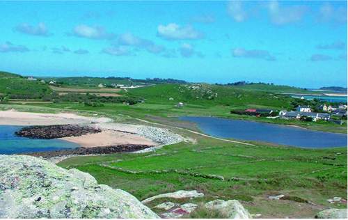
FIG 39. Bryher from Gweal Hill, looking towards the saline Pool and Great Popplestone Bay, June 2002. (Rosemary Parslow).
beaked tasselweed Ruppia maritima and fennel-leaved pondweed Potamogeton pectinatus. Saltmarsh rush Juncus gerardii, sea club-rush Bolboschoenus maritimus and at least one species of spike-rush Eleocharis sp. grow all round the edge of the pool. A few birds frequent the pool. Moorhen usually nest and gadwall Anas strepera, mallard A. platyrhynchos and mute swan Cygnus olor are often seen there. But the salty water restricts the number and species that live in the pool, so dragonflies, for example, cannot breed there. A second very small pool nearby at one time would have been covered in brackish water-crowfoot Ranunculus baudotii and one of the starworts Callictriche sp., but for some years it was planted up with water-lily and other pond plants. Now these have been removed it is returning to its former state.
Close to the pool on the brow of Great Popplestone Bay, as well as elsewhere on short turf, grows a lovely red form of white clover, Trifolium repens var. townsendii, often in its most extreme form with purple-red flowers and almost black leaves. And as you walk over the short turf here the unmistakable scent of chamomile rises about you. Spring squill, which is otherwise uncommon in Scilly, is at its best on Bryher. It grows in the short maritime turf along the slopes above Hell Bay, along much of the west side of the island and also below Samson Hill. Even when the flowers are over, the leaves persist for a while, lying curiously twisted on the ground as though they have been poisoned.