Полная версия
Taming the Flood: Rivers, Wetlands and the Centuries-Old Battle Against Flooding
THE CULTURAL HERITAGE OF RIVERS
It is not only wildlife that is at stake. Rivers represent a cultural heritage as well. Through aeons of geological time, rivers, in the wake of glaciers, have helped shape the very structure of our landscape. When civilization arrived, rivers shaped human history, and humans, in turn, began to shape the rivers.
From the time that the tribal Belgae and then the Romans invaded England, rivers dictated the positions of many towns and villages. It is believed that the great bluestones of which Stonehenge is constructed were floated up the Wiltshire Avon. Christianity came to England up a river, when St Augustine and his forty monks travelled to Canterbury up the Kentish Stour, ‘singing all the way’. Rivers were also highways of terror. The sleek hull of a Viking boat was specially designed to be shallow enough and narrow enough for use on navigable rivers, along which Norsemen brought fire and the sword. Along the waterways was carried most of the stone required to build our medieval cathedrals. When Whittlesey Mere was drained in the 1850s, a heap of dressed stone was found at the bottom of the lake, evidence of a medieval boating accident. It is thought that the cargo was destined for Crowland Abbey.fn5
In the eighteenth and nineteenth centuries the harnessing of water power for mills, and river navigation, interlinked with a new system of canals, laid the foundation for the Industrial Revolution. Through all this change, rivers have continued to flow; but, for those who have eyes to see, the imprint of each generation remains, varying and concentrating the character of each stream that flows past our homes and our lives.
A good example of this is the water mill. The Romans introduced water mills to England, and the Domesday Book records as many as 5,624. All but a hundred of these mill sites can still be accounted for. Up and down rivers and brooks, the remains of some of these and many later water mills can be seen. In some cases, magnificent buildings, complete with all their machinery, still stand. Elsewhere there are just clues to former occupancy: foundations, a silted millrace, or the remnants of a weir, as described by Edward Thomas:
Only the idle foam
Of water falling
Changelessly calling,
Where once men had a work-place and a home.6
All this human interference with rivers, the building of millraces and millponds and, in some cases, quite major diversions of watercourses, did not destroy the essential character of rivers. On the contrary, it added to it, and not just in terms of the quality and character of the landscape, but also from the point of view of the wildlife. A tumbling weir creates the localized conditions of an upland brook wherever it crosses a silty lowland stream. Here grow the willow moss and liverworts found again in abundance only towards the sources of a brook. In the highly oxygenated water below a weir swim the little fish not known for nothing as the ‘miller’s thumb’: the flattened head of the fish was often compared with the thumb of the miller, worn it was said from testing the flour. Perhaps the loveliest of upland specialists associated with weirs and mill sites is the grey wagtail – grey in name, but not in appearance, with the flash of his canary-coloured chest. The grey wagtail nests in ledges and crevices of rock upstream, and finds a similar home in the crumbling walls and vertical structures of water mills. Edward Thomas may not have known that he was also making an ecological point when he pinned down so precisely the atmosphere and feel of these places:

Attractive colonizers of the mill weirs. Grey wagtail and the delicate leaves of skullcap.
The sun blazed while the thunder yet
Added a boom:
A wagtail flickered bright over
The mill-pond’s gloom.7
Some of the wildlife of the water mill may owe its existence to a rather more conscious decision on the part of some long-dead miller. Growing along old millraces or near millponds are some of the stoutest and hoariest of pollard willows, which are the glory of any river bank. This is no accident. The willow was put to many uses by millers. An integral part of mill machinery was a simple spring known as the ‘miller’s willow’. In the most recent mills it was made of steel; but more commonly it was a piece of springy willow wood collected from a convenient pollard. Willow was also used for eel traps, and the fact of a river being carefully directed to drive a water wheel has always made water mills very convenient places to catch eels. The Luttrell Psalter of 1338 illustrates a water mill complete with eel traps which look very much as if they have been made out of pliant willow stems. Many medieval millers paid their rent to the lord of the manor in eels; and when the water mill in the centre of Stafford was pulled down after the Second World War, the laconic miller expressed as his only regret: ‘I shall miss the eels.’
More recently, eel traps have been built into the systems of weirs and sluices of water mills. Yet these structures, too, add variety and local character to rivers. The joints in a timber lock-gate or the eroding mortar of a sluice often provide congenial conditions for gipsywort or skullcap, with its clear blue flowers. Both these delicately proportioned plants have more difficulty competing with other vigorous vegetation on the open river bank than they do in the neat crevices provided for them by mill structures. The structures themselves were often built of local materials. Before the advent of railways, it was cheaper to do this than to import materials from far afield. Later, bricks were commonly imported, but even these, including the splendid ‘blues’ of the industrial Midlands, added their individual stamp to river landscapes. Nevertheless, it is surprising how often local builders simply took advantage of what was at hand. In 1985 a land-drainage scheme was carried out on the river Erewash near Eastwood in Nottinghamshire. This is the river which flows as a constant theme through the novels of D. H. Lawrence. Just opposite the point where the brook that runs past Lawrence’s old home joins the Erewash itself stands a mill sluice. In the normal course of events this would have been ‘tidied up’ – wiped out as part of the scheme and conveniently buried. But in this case the enlightened engineer was concerned to do precisely the opposite, and as the digger pulled back the rubble, an area of wall was exposed, which looked for a moment as if it were made entirely of shiny cream bones. This turned out to be pottery waste, a surviving memorial to a now vanished china factory in the local town. There it now stands, its cracks colonized by ferns and wormwood – nothing especially beautiful in itself, but a piece of history and natural history, with literary associations thrown in.
Builders in the wetlands did more than that, however. They built their homes out of the materials of the river bank itself. Whereas in most parts of England, thatched roofs were made of locally available straw, in the lowlands, especially in East Anglia, the common reed was used – the same plant that provides a home for a whole hierarchy of warblers, moths, and bees. And very good thatch it made. It is still often known as Norfolk reed; and in contrast to ordinary straw thatch, which has a lifetime of thirty years at most, a well-laid thatch of Norfolk reed may last as long as eighty years. In the wettest wetlands of all grows an even tougher thatching material, one of our most ancient natural crops: the giant saw sedge, Cladium mariscus. This, one of the dominant plants of the undrained Fens, can still be seen on the roofs of some of the houses between Ely and Newmarket. In some cases this most durable, but increasingly unobtainable, material is used as a capping ridge to a thatch of Norfolk reed. In other places, where even the Norfolk reed is scarce, the reed is used as a capping ridge to straw thatch. The final flourish in this humanizing of the natural landscape is given by an individual, as the thatcher in Ronald Blythe’s Akenfield explains: ‘We all have our own pattern; it is our signature you might say. A thatcher can look at a roof and tell you who thatched it by the pattern.’8
Elsewhere the landscape has been modified by humans less consciously, by providing congenial conditions for the river water crowfoot. The water crowfoots are a particularly lovely group of river plants. To the non-expert they all look pretty similar: crisp emerald weed buoyed up in the stream and then, in July, a snow in summer of glistening white flowers, which spill over the water in a way that seems to spell out the brief abundance of midsummer. The nine or so different forms and species to be found in England are all specialist. The pond water crowfoot has broad-lobed leaves which float on the still surface, in addition to dissected underwater foliage. At the other end of the scale are crowfoots of fast waters, whose only leaves are bunches of slender threads which run with the current – the ‘crow’s feet’. The river water crowfoot, Ranunculus fluitans, grows in gravel, and dies if it becomes too covered up by silt. Studies made on the river Lugg in Herefordshire show that the rubbly remains of fords or bridges which collapsed long ago have created a gravelly river bed which encourages crowfoot. The Lugg is in general a silty river, although it has natural riffles of gravel where the crowfoot also occurs. Elsewhere, however, known historical fords or bridge sites can be picked out every high summer when the crowfoot blooms – literally, living history. The same effects are visible in the river Wye in Hereford where the site of the early ford below the Bishop’s Palace is picked out in white in July when the water crowfoot is in flower. There is even a gap in the centre with no flowers where the material marking the ford was probably removed at a later date to allow passage for the boats, leaving a silty bottom to the river in that place unsuitable for the growth of water crowfoot.9
Our predecessors’ efforts to farm and drain the land can also be ‘read’, again in white and green, at a very different but particular moment of the year. If you stand on a hill in winter when there is a thaw, or look across an expanse from a motorway, especially in the Midlands, you can hardly miss the pattern of long parallel bands of snow, which are always the last to go from the hollows of the old ridge and furrow. In summer, too, you can read the ridge and furrow in an even more attractive way, although this is possible only on those few fields which have not been ‘improved’ to an all-over green of fertilized rye-grass. In such meadows there is a specialized flora for the damp furrow bottoms, subtly distinct from the flowers and grasses of the dry ridge crowns. The bulbous buttercup (Ranunculus bulbosus) prefers the tops, while the creeping buttercup (R. repens) favours the hollows. Ridge and furrow were formed any time between the early Middle Ages and the nineteenth century, as a result of ploughing up and down fields in parallel lines. This is generally thought to have been done deliberately, to improve drainage in the days before clay and, more recently, plastic field drains. In fields next to a river, the furrows are noticeably at right angles to the stream, although in some other places, where no obvious drainage benefit was gained, ridge and furrow seem to have been simply a by-product of the normal way of ploughing. If you look carefully, you may see some ridge and furrow which lie in a reverse-S pattern, a result of the logistics facing the medieval ploughman, who had to manœuvre eight oxen up and down a field. The Tudor ploughman had better-bred and better-fed beasts; so he required fewer of them to pull a plough, and was able to drive a straighter furrow.fn6
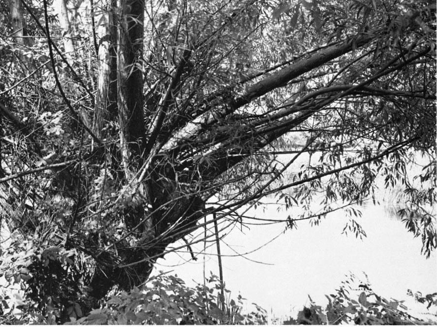
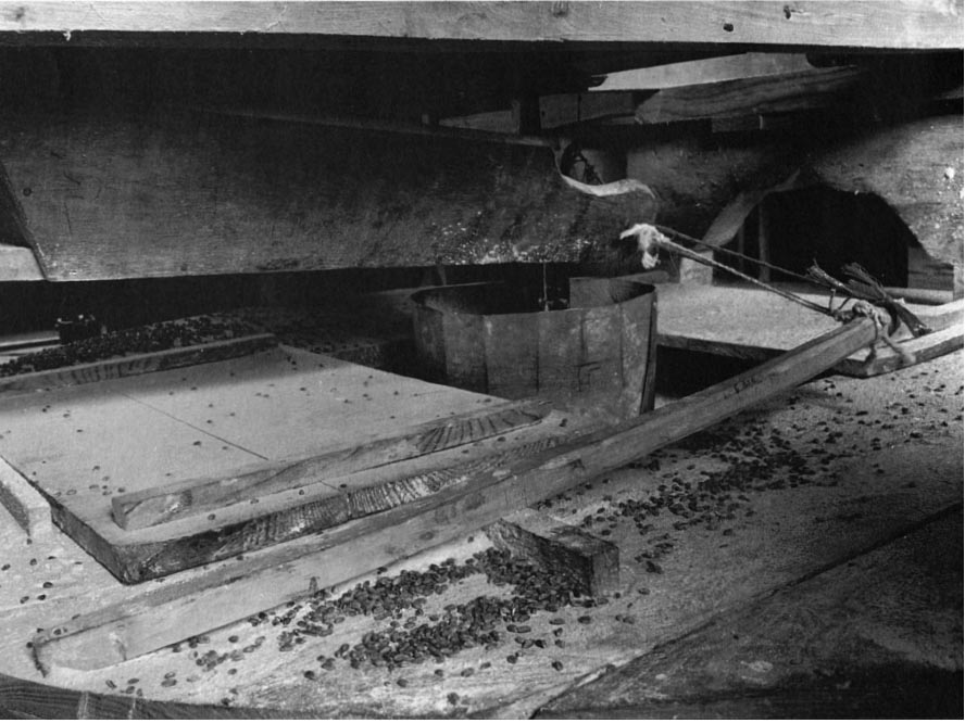
A pollard willow beside a water mill (top). ‘The miller’s willow’, a springy piece of timber, still gathered from the convenient pollard, for use as an essential part of the mill machinery. Charlecote, Warwickshire (bottom).
These are the monuments to generations of individual farmers ploughing and draining their fields. When, in the seventeenth century, the first real drainage engineers arrived, equipped with a literally world-changing technology, they too left their monument, in the shape of an entirely new landscape: the Fens. Despite their new-found power, however, they did not succeed in totally obliterating what had been before. Meandering across the geometrical landscape of straight ditches and square fields which the new engineers and their successors created, the winding courses of the original pre-drainage creeks and rivers can be seen especially clearly from the air. As they flowed on their – as it turned out – not so eternal journey from the hinterland of Ely and Cambridge to the Wash, these rivers deposited silt along their beds; and now, although the rivers vanished centuries ago, this silt stands out, a startling pale-fawn colour, as it snakes across the adjacent black peat of the Fens. Thus you can still pick out with ease the route of the ancient Wellestream, along which, in the fourteenth century, came cargoes of cloth from the Low Countries and silks from Italy, not to mention news of the dawning Renaissance, bound for Cambridge and beyond. Even more astonishing is that you can see the Wellestream more easily with every passing year. This is because the adjacent peat, as it is drained and dried out, wastes away by a process of oxidation on exposure to the atmosphere. Hence the old silt river beds, known in the Fens as ‘roddons’, are rising steadily as ridges above the ever-falling peat. They are landscape ghosts; but instead of fading away, they sharpen ever more clearly into focus.
Rivers have always been boundaries, as well as route-ways. They dictate the shape of many land-holdings, parishes, counties, and even parts of the Welsh and Scottish borders, as is well known to the poor river engineer who has to negotiate with different landowners, not to mention councils, on opposing banks as they try to promote their schemes. With boundaries go hedges, and some of those still remaining have been part of the farmed landscape since Saxon times, or possibly even earlier. Boundary hedges tend to be the oldest hedges, and a number of these are found bordering brooks and streams. Techniques developed by botanists and historians have shown that it is possible to assess the age of a hedge by the number of shrub species it contains.10 So the hedges that most interest the historian are those that most fascinate the botanist. To the layperson they are also arguably the most beautiful, with all the tangled richness and variety of oak, ash, buckthorn, elder, and wild rose. In general, a hedge will contain in a 30-yard length one shrub species for every century of its life. This is not an immutable law, but the correlation has been sufficiently demonstrated to be a valuable guide.
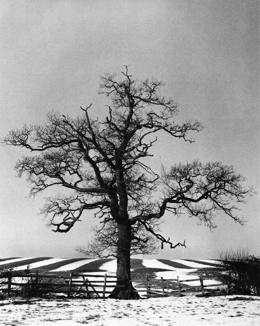
Snow picks out the ancient ridge and furrow, which is overlain by enclosure hedges. Warwickshire.
These are the relationships that print the character on the landscape. It is the same with the various damselflies in their clay and gravel streams, the water mill with its grey willows and grey wagtails, and the crowfoot crowning the ford and the curve in ridge and furrow. This is what the Englishness of England is made of, and it is this sense of place that we are currently in danger of losing, just as we come to understand it more clearly. It is far more important than any particular beetle or bird or ancient monument. The long evolution of the natural system, further evolved by human management, has given brooks and rivers individual characters as distinctive as their names, names which invest the Ordnance Survey map with an idiosyncratic quality ranging from poetry to comedy: the Windrush, the Swift, the Wagtail Brook, the Mad Brook, the Hell Brook, the Piddle, the Wriggle …
Take another look at The Hay Wain. Constable was a miller’s son, and probably knew all there was to know about mills such as Flatford. He was concerned here above all to paint a working landscape, not just a decorative one; and the empty wain is fording the stream to collect more hay from the labourers in the distant field. It was probably there for another reason too. George Sturt, who wrote about his practical experience of running a wheelwright’s shop at the end of the nineteenth century, describes the constant problem of shrinkage of timber wheelstocks in high summer:
Men who used carts knew something about the advantage of a little moisture for tightening wheels. Not for the horse’s sake alone was it that carters would drive through a roadside pond, or choose to ford a stream rather than go over a bridge beside the ford. The wheels were better for the wetting.11
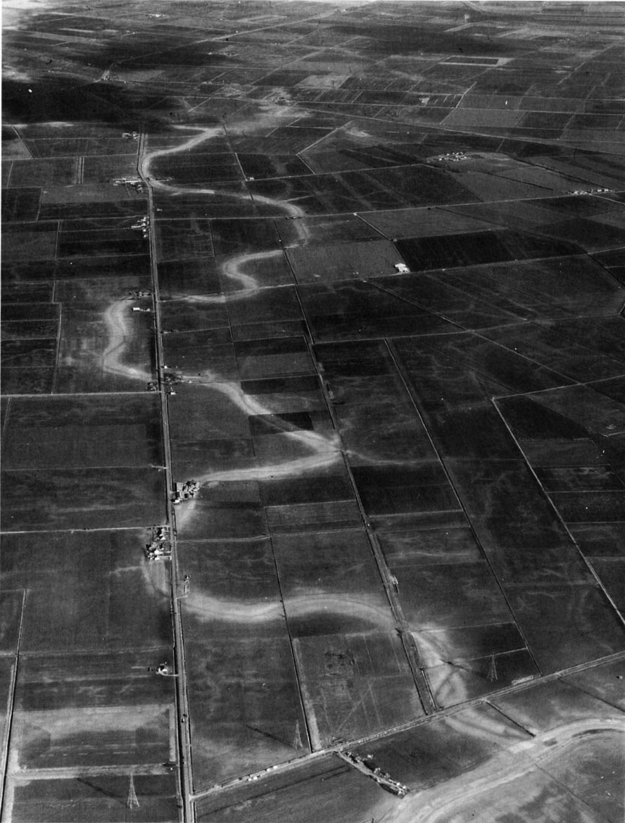
The ghost of a long-vanished river winds across the level geometry of the Fens. The silt bed of the old river now stands out against the adjacent black peat. © Cambridge University Collection of Air Photographs.
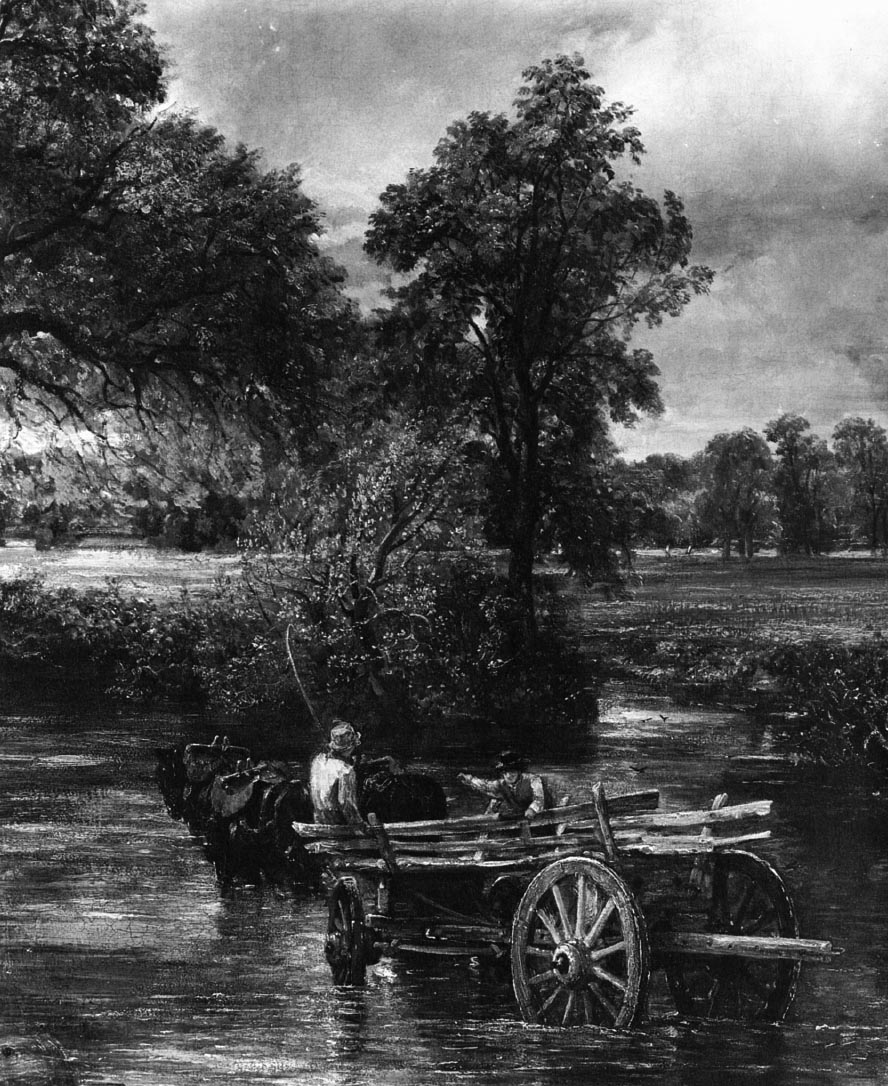
Cartwheels soaking in the river in order to tighten them. Constable’s famous hay wain was part of a working landscape, not simply a picturesque one. © National Gallery.
Sturt and others record how wagons for the Sussex clay country were designed with broad wheels, while those for downland chalk had narrow ones. Taking individual orders from customers, the wheelwright built each cart for the particular conditions of a particular farm. This is taking a sense of the particular about as far as you can go: humanity evolving as harmoniously with the landscape as the mayfly nymph evolved in harmony with its stream. No wonder farmers tell us that they are the creators and guardians of the English countryside.
Now, for the first time in the long history of settling our islands, the guardians have become the destroyers. The landscape that generation after generation created is like a classroom blackboard at the end of a day, on which each lesson has been written without entirely erasing the previous one. Medieval ridge and furrow are overlain by a grid of more recent hedgerows. The winding Wellestream can be glimpsed through the level geometry of the Fens. In the space of a generation, we have set about wiping the blackboard clean.
THE IMPACT OF RIVER MANAGEMENT
Rivers and streams have been straightened and evened out as never before. This work has been carried out by water authorities, internal drainage boards, and many councils, in part to reduce flooding of roads and houses, but largely to increase farm yields. In the years between 1971 and 1980, an annual average of 207,217 acres was estimated to have been drained, of which ‘new’ drainage of wetlands comprised around 20,000 acres per year.12 One straightened stream begins to resemble another. River organisms’ ability to survive the disruption of floods was never evolved to withstand this kind of onslaught. Repeated dredging has removed the weedy margins upon which dragonflies depend. In the last twenty-five years, four dragonfly species have become extinct in England, while many others have shown a marked decline. Reduction of such insect populations will in turn reduce the fish population, which depends on a diversified, rather than a straightened and uniform, channel. With the loss of the fish, we can expect to lose the electric-blue flash of the kingfisher. The dredgings are put in the bottoms of furrows or are used to fill in ponds. With the virtual disappearance of the farm pond, frog populations in some parts of England declined drastically between the 1950s and the 1970s.fn7
Many streams have been stripped of their ancient boundary trees, and the knock-on effect of the drainage schemes has been to encourage farmers to turn their farms into prairies. Between 1946 and 1963, around 85,000 miles of hedges were grubbed out.13 The lowering of water levels to allow ploughing of damp pasture has removed the nesting habitat of many birds that we used to take for granted, such as snipe, lapwing, and redshank. A survey of Oxfordshire in 198214 found only 15 breeding pairs of redshank, compared to 112 pairs in a similar survey in 1939.fn8
Studies have shown that the water vole, ‘Ratty’ of The Wind in the Willows, has become scarce in many areas, due to intensive management of river banks.15 Indeed, Ratty’s emotional, if not his ecological, headquarters, the river Pang between Reading and Newbury, where Kenneth Grahame wrote his classic, has been subjected to a notoriously insensitive drainage scheme.fn9
In some counties, such as Staffordshire, a previously common wetland plant such as reed has become a rare sight. The remains of water mills have been consistently removed; the weirs that hold up river levels have been dismantled; and millponds and millraces have been filled with the dredgings. On the Worcestershire Stour, ten mill sites have been removed in as many years. The ancient fords which hold up the water are dredged out, along with their water crowfoot. In the late 1970s, the Anglo-Saxon ‘stretford’ of Stratford-upon-Avon was taken out.
The inexorable desiccation of the Fens, the Somerset Levels, and the Lancashire mosses is exposing remarkable artefacts of early civilization, long preserved in the wet peat. But in the absence of an effective liaison between drainage engineers and archaeologists, there is a danger that such remarkable finds as the Bronze Age settlement built on a timber ‘island’ recently rescued at Flag Fen near Peterborough could be broken up by diggers or left to crumble on exposure to the atmosphere.16 fn10
Major wetlands are obvious victims of drainage. Casualties since the Second World War have included the river Idle washlands in Nottinghamshire and large parts of Romney Marsh, Otmoor, and the Lancashire mosses. Major debates have been held since the late 1970s over the future of wetlands in Sussex, Somerset, Yorkshire, and East Anglia. Wetlands under threat have included a variety of landscapes: swamps of tall reed or reed sweet-grass; marshes of rush and sedge, which sometimes develop into scrub of willow and bog myrtle; fens, whose lush vegetation is nourished by alkaline groundwater, and which range from open pools, often the remains of peat cutting, to grazed beds of meadowsweet and iris, grading in turn to the wet woodlands known as alder ‘carr’. Additionally threatened are mires such as the mosses of the north-west, whose deep peatlands support sphagnum moss and heather, scattered with glades of birch, the favourite haunt of nightjars. Finally, there are flowery hay meadows and damp pastures, intersected by dykes patrolled by dragonflies in summer and all submerged in winter by the silver flood, which draws in dark clouds of wildfowl and companies of wild white swans. The destruction of such places in our time has been startling.
In 1983 the chief scientist of the Nature Conservancy Council, the Government’s watchdog on conservation, produced a definitive report on the destruction of habitat in Great Britain since 1949.17 Among the casualties wholly or partly attributable to drainage were 97 per cent of herb-rich hay meadows, 50 per cent of lowland fens, and 60 per cent of lowland raised mires, all lost in the space of a generation. In the mid-1980s the Norfolk Broads were losing an average of 1,500 acres per year.fn11
All this has happened because enormous sums of public money available for drainage schemes since the Second World War have combined with a revolution in technology with which we have not yet fully come to terms. I will always remember standing one early spring day near the river Severn, arguing with a drainage officer who had previously maintained watercourses, which were now due to be reshaped as part of an expensive new scheme. This man had as little sympathy for the environment as a pike might have kind feelings towards a minnow. Yet the point he rightly argued was that, for the previous thirty years, he had personally controlled the maintenance of the ditches and hedges of this parish, so why should he now consider newfangled ideas about nature conservation? I looked at what he had created. In spite of his indifference, it was exquisite: the ditch banks were creamy with cowslips and lilac with cuckoo flower. Chiffchaffs were arriving to nest in the spangled scrub of blackthorn. There was a badger sett under some old pear trees. I asked him how he managed the place. It turned out that he had a small dredger, an even smaller budget, and a very primitive brand of mowing machine. With this equipment he had efficiently kept water flowing through his ditches. I lost the argument that day. Within a week the big machines had moved in, and that corner of his parish could have been one of thousands of others in modern England – any place, anywhere.


