

Полная версия
Life in Lakes and Rivers
Table 4. Some dissolved substances in the Tees near the end of the first part, that is above any pollution
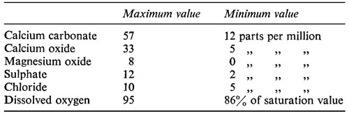
The average amount of calcium is about 12 parts per million, and so the water is soft although the river has been flowing over limestone. But there are big fluctuations in the concentration of all the substances except oxygen, which is plentiful at all seasons and at all times of day and night.
Trout occur in this part of the river and may be taken almost up to the source. They are plentiful but of small size, the average length being but six inches (15 cm.).
The next part of the course extends all the way down to Croft, which is at the point where the river changes in character. The river crosses several geological formations, which affect its nature, but it remains rapid throughout with a bottom of bare rock or stones. There is hardly any rooted vegetation.
The main difference between this and the preceding part of the river is that it receives sewage effluents from towns along its route. The first place of any size is Middleton-in-Teesdale, some twenty-two miles from the source, and the biggest is Barnard Castle, about eight miles farther on. The population connected with the sewage systems of the two places was 1,700 and 5,000 respectively when the survey was made. Below the outfalls there were changes in the flora, and there can be no doubt that these changes were directly attributable to sewage and the products of sewage decomposition. Below some of the larger works the dominant organism on the river bed was the sewage fungus. Father downstream there was a characteristic association of algae, but this finally gave place to the same association as was found in the upper waters, where there was no pollution. Below the smaller sewage outfalls there was no sewage fungus, but there was the characteristic change in the algal community encrusting the stones and boulders. In all this part of the river the amount of sewage was small compared with the volume of water into which it was discharged and pollution was not great. Oxygen concentration in the summer was lower than in the first part of the river (Table 4) but it never reached a seriously low level. Chloride rose, probably as a result of the sewage. The amount of calcium also increased and an average figure just above Croft was 24 parts per million; this rise was probably mainly due to the limestone over which the water had flowed.
Trout occurred throughout this part of the river and reached a greater size than in the first part, 1/4 to 3/4 lb. (120–360 g.) in weight with a few specimens of 3–4 lb. (1.4–1.8 kg.). It contained minnows almost throughout, and grayling in the lower half; thus, although there are no marked physical changes, the river enters the third of Carpenter’s zones in this part of its course.
At Croft, 100 feet (30 m.) above sea level, there are several important changes in the river. It enters a great clay plain, laid down during the Ice Age, and flows across this in a meandering course, though with a fair flow. The stretch is too fast for a typical lowland course judged on purely physical grounds, and it is probably in the third of Butcher’s five zones, for Ranunculus fluitans is one of the commonest plants; but it is in the last of Carpenter’s four classes since coarse fish abound. Other changes are due to the confluence of the River Skerne, a large tributary, which is more calcareous and much more heavily polluted than the Tees. These three factors, different kind of bed, more calcium, and more sewage products, all influence the biology of the river below Croft. but it is not possible to measure exactly how great a part each one plays.
Most of the bed of the river is of medium-sized stones and gravel but there are occasional patches of sand. In water shallower than five feet typical plants are the water crowfoot, Ranunculus fluitans, and various species of pondweed, Pota-mogeton. These plants can colonize the gravel and sand, and when they have formed a large patch they cause a stagnant area on the downstream side. Silt settles here and accumulates rapidly if there is heavy pollution upstream. It is colonized by such plants as Nitella, the stonewort, Elodea, the Canadian pondweed, and Potamogeton crispus, the curly pondweed.
There was usually sufficient water in the Skerne to dilute the sewage it received to below the danger point, but in one summer there was a long hot dry spell as a result of which all the oxygen was used up, and the toxic products of decomposition without oxygen were liberated into the water. The Skerne itself had a thick coat of sewage fungus on its bed, and this organism extended for some distance down the Tees below the confluence of the two rivers. Its range varied widely according to the season of the year. In winter when, owing to the low temperature, the rate of decomposition of sewage is slow, it extended a long way downstream from the mouth of the Skerne, but in summer, when decomposition is more rapid, its range was less.
A green filamentous alga, Cladophora glomerata, the Blanket Weed, abounds where nutrients are plentiful, as they are below a sewage outfall where the organic matter has undergone the initial stages of decomposition. It appeared in the Tees towards the end of May and grew rapidly to form a thick carpet in the shallow water a long way down the river from Croft. Then the first flood in July would usually sweep it all away, and it would be seen no more until the following year. If it lasted long enough, it trapped a deposit of silt and enabled rooted plants to grow in places where otherwise the flow was too fast. Before the estuary was reached the algal community typical of the upper, unpolluted reaches had become re-established on the stones.
Nitrogenous compounds and other products of decomposition were brought into the Tees by the Skerne, and the calcium concentration was increased to some 30 parts per million. There was less oxygen in this stretch during the summer than there was farther upstream, and the lowest value was reached during the time when the development of Cladophora was at its height. The dense growth of this plant, respiring in the hours of darkness, used up much of the oxygen and reduced the concentration to between 50 and 60% of the saturation value. This is well above the point at which deleterious effects on fish are likely, and trout flourished in this, the last freshwater reach of the Tees, not uncommonly attaining a size of 1–11/2 lb. (.45–.75 kg.). Coarse fish, chiefly dace and chub, were abundant, and fishing was a popular pastime.
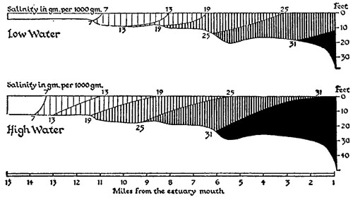
Fig. 12 Longitudinal section of the Tees estuary showing the salinity at high and low tide
In the estuary, surveyed by Alexander, Southgate and Bas-sindale (1935), the most important natural phenomenon is the salinity. The fresh water tends to float on the sea-water and the result is a marked stratification. Figure 12 shows the average conditions at high tide and at low tide, but it gives rather a distorted picture because it is necessary to use such different scales. Horizontally an inch represents about three miles, but vertically it represents only about fifty feet. The surface current of fresh water draws up some water of higher salinity from below it, and to replace this there is an upstream creep of water of high salinity along the bottom. The whole mass moves up and down with the tide as shown in the figure. It is estimated that the mean time for all layers of a body of water to pass through the estuary is about six days in dry weather, decreasing to about two and a half under average winter conditions.
The estuary has been much changed by the hand of man, and it must be admitted with regret that the Tees is typical rather than otherwise of larger British estuaries. From about midway nearly to the sea there is an extensive industrial conurbation. This requires a navigable channel so that its products may be removed by sea, and accordingly the natural tendency of the river to drop silt where it is checked by its meeting with the sea is counteracted by the continual activities of dredgers. The river is a convenient main drain and, at the time of the survey, the sewage from rather more than a quarter of a million people was discharged into it untreated. So were a variety of industrial waste products, of which the most important were tar acids and cyanides. Both these decompose gradually in the water.
Much water is taken in to cool condensers and machinery, and this results in a slight rise in the temperature of the estuary. Oxygen, it need hardly be said, is not plentiful in solution in the water. The amount used up depends on the temperature and also on the salinity, being greatest at salinities of between 15 and 25 parts per thousand. The lowest concentration of dissolved oxygen recorded during the survey was 9% of saturation.
The curly pondweed, Potamogeton crispus, the starwort, Callitriche stagnalis, and the two mosses, Fontinalis antipyretica and Eurhynchium rusciforme, which are abundant throughout almost the whole length of the freshwater part of the river, penetrate a little way into the brackish water. A few seaweeds penetrate a short distance from the sea but only four extend beyond the fringe of the brackish water region. Fucus vesiculosus, one of the brown bladder wracks, extends to beyond the middle point of the estuary, growing on wharves and piles between tidemarks; and three species of filamentous green algae occur throughout the brackish region.
It is difficult to determine exactly which fish dwell permanently in the estuary, as so many of the species recorded are migrants passing through, or casual invaders, but the threespined stickleback appears to be a regular inhabitant, extending down to at least the upper reaches of the polluted part. The effect of the pollution on the fish, particularly the regular migrants, and on the lower animals is described in Chapter 14.
Reviewing the River Tees in the light of the classifications put forward at the beginning of the chapter, we find that it includes all of Carpenter’s classes, for the lowest reach, immediately above the estuary, is dominated by coarse fish. On the other hand the last two classes, numbers 4 and 5, of Butcher’s botanical classification are not represented, for the current is nowhere so sluggish that the water crowfoot ceases to be the dominant plant.
A contrast to the Tees is provided by the south country rivers rising in the chalk downs. Butcher has surveyed the plants of the Itchen, and there was a fisheries research station on the nearby Avon for several years before the war. Much of the gathering ground is chalk down. Rain falling on this sinks in and percolates relatively slowly so that it may not reach a hill-foot spring for months. The effect of heavy rain is, therefore, dissipated and it will not produce a marked flood wave as in the Tees. The other effect of the chalk is, of course, to render the water highly calcareous, and Butcher quotes a figure of 92 parts per million of calcium in the River Itchen.
Then the slope is not so steep. Moon and Green (1940) give a profile of the Avon and show that between Christchurch, which is at the mouth, and Salisbury the fall is about 150 feet in 39 miles, which is a little less than 4 feet per mile (0.075%). The river rises some 20 miles from Salisbury at an altitude of about 350 feet, so this upper reach, for which we have not been able to find accurate data, is somewhat steeper, and the figure for the whole river will be greater, but still far below that of 30 feet per mile (0.57%) for the Tees.
The springs giving rise to the Avon headwaters are usually at the foot of the chalk and often flow in wide valleys floored with gravel. Sometimes the streams have been broadened so that they flow over wide areas in which water-cress is cultivated. In dry weather the water-table often sinks below the surface of the gravel covering the impermeable stratum which is the true valley floor and the stream disappears. Sometimes, owing to the time which rain takes to seep through the chalk, there may be a long interval before the effect of a dry spell or a wet spell is manifest in the river.
Below Salisbury the Avon has been put to a variety of uses by man. One of the characteristic features is water meadows, although the method of farming under which they were engineered is now obsolete. The principle is to take water from the river in a main canal, which can be filled by the manipulation of sluices across its mouth and a barrage across the river. From this main canal the water is led into many subsidiary channels, from which it eventually runs over the land. It is gathered up in a complementary series of collecting channels and led back to the river at a lower level. The advantage of this system was that the grass could be watered at certain critical times of the year, and the farmer was independent of the capricious rainfall of this country. The significance of water meadows in the economy of the river today is that a great deal of flood-water finds its way on to them and runs back to the river slowly. This is a second reason why the effect of flooding is much less fierce in the Avon than in the Tees.
Dams and weirs are thrown across the Avon not only to deflect water for irrigation purposes but also to pen up a head of water to provide power for mills. Weirs and side channels to take excess water when the level of the river is high are usually to be found in connection with mills, and the result is that the river does not flow in a simple single channel but in a maze of anastomosing channels.
The water is rich in nutrient salts and, since there is no great scouring by floods, the rivers flowing from the chalk are heavily overgrown with a variety of aquatic plants. Butcher records that the commonest plants of the River Itchen are: Ranunculus pseudofluitans, water crowfoot, Sium erectum, the lesser water parsnip, and Apium nodiflorum, where the current is fastest; Hippuris vulgaris, the marestail and Sparganium simplex, the simple bur-reed, where it is somewhat less rapid; and Elodea canadensis, the Canadian pondweed, and Calli-triche stagnalis, starwort, in the slowest reaches. The vegetation forms such thick beds that it has to be cut and removed to let the water pass, and also to make fishing possible.
Besides the game fish, for which these rivers are famous, there is a plentiful and varied population of coarse fish.
The Avon has no torrential head-stream region nor a typical meandering lowland reach. The whole river occupies a place somewhere in between these two, but it cannot be made to fit exactly into any of the various schemes of classification. There is no steady loss of gradient from source to mouth, as there is in the theoretical river, but a mosaic of faster and slower reaches due to the various artificial obstructions which man has thrown across the river.
A third river worthy of notice is the Lark, another of those surveyed by the Ministry of Agriculture and Fisheries team in connection with pollution (Butcher, Pentelow and Woodley, 1931). It is a small river rising in the East Anglian heights and flowing in a west by north direction to join the Ouse. The water is highly calcareous like that of the River Avon.
Only a comparatively small portion was surveyed, but this stretch is fraught with interest because it illustrates yet another effect of human interference. It may be remarked here that no south country river of any size is in a ‘natural’ state, and any account of it must dwell at some length on the modifications imposed by man.
The River Lark was once navigable as far up as Bury St Edmunds, though the last few miles were kept open with difficulty because the gradient was rather steep and the amount of water available was small. Eventually river traffic ceased to pay, and the locks fell into disuse. They are now derelict and the river flows in a bed which, having been widened to take barges, is too large for the volume of water which flows down it. This disproportion is particularly marked in one stretch which is now heavily overgrown with two emergent reeds, Glyceria aquatica, reed poa, and Sparganium erectum, the branched bur-reed. These plants probably established themselves first on beds of silt in shallow water. Their gradual spread would impede the current still more and result in further deposition of silt, and the process has continued and was still active at the time when the survey was made. The dense growth of reeds tended to deflect the current to the side, where it encountered and eroded a soft sandy bank, and so made yet bigger the area in which conditions were suitable for reeds. A stage had been reached where, when the reeds began to grow up early in the summer, above them the river flooded even though there had been no unusual rainfall, and below them a miller was hard put to it to obtain sufficient head of water to drive his mill.
Beyond this stretch overgrown with reeds there is a stretch overgrown with submerged pondweeds. In parts of it the current is sufficiently strong to keep a gravel bottom clear of silt and the water crowfoot is the dominant plant. Elsewhere the current is sluggish, the bottom is muddy, and the chief plant is usually Potamogeton lucens, the shining pondweed. In some places it is replaced by a community in which Spar-ganium simplex and Sagittaria sagittifolia, the arrowhead, are the dominant species. There was no evident difference in the river to account for these two distinct communities and at first they provided something of a puzzle. But a study of the activities of the human beings interested in the river at length provided the clue, and it was noticed that the bur-reed-arrowhead community was found in those parts where weed-cutting was most frequent.
Finally the river runs through a stretch of fenland before joining the Ouse, but unfortunately the survey stopped at the head of this stretch. The fenland river offers the extreme example of the lowland course. Left to itself it would follow a tortuous channel beset with marshes and stretches of open water. Changes of course might occur and the stream might split up and lose its identity in a number of small channels as does the Euphrates today. Figure 6 shows the lower part of the Euphrates and the Tigris, and gives a good picture of a lowland course which has hardly been interfered with. In Britain no fenland river is left to itself. The fen soil is valuable for cultivating and the rivers are important as the means whereby the water pumped up out of the fens is got rid of. Vegetation, which would impede the flow of water, is removed and the channels are constantly dredged. Flood-banks are raised on either side, often at some distance from the river’s brim, so that an expansion in width is possible when the river rises above its natural banks. Water left behind by a flood stands for a long period in this land between the river and the flood-bank, and the resulting ‘washes’ are characteristic features of the fenland landscape.
Most waterways were not created by man, though he has modified some of them considerably, but there is one group that owes its existence to human effort – the canals. The Exeter ship canal was built in the sixteenth century and a few artificial waterways persisting to this day date from even earlier times. But the title of ‘father of inland navigation’ is usually bestowed upon the third Duke of Bridgwater, at whose instigation a canal from Worsley to Manchester was built and opened in 1761. The commercial possibilities of this new means of transport were quickly exploited, and in the next forty years nearly 4,000 miles of canal were put into operation. After about 1800 the activity began to wane as the challenge from rail and road became ever greater. Today some of the canals have disappeared and others, though still containing water, are no longer used.
Even a used canal is surprisingly rich in animal life and an unused one is highly productive. Canals are almost confined to the lowlands and so their water is usually hard and rich in nutrient salts. There is sufficient flow to keep these replenished; but there is no danger of excessive flow after heavy rainfall of the kind which may wash away so much plant and animal life from the canal-like stretch of a river.
Furthermore canals link up all the main river systems draining central England. Boycott (1936) writes: ‘And about the middle of last century a snail could start in the Thames at London and travel in uninterrupted water to Norfolk or Leeds or Kendal or Newtown in Montgomery or Hereford or Trowbridge, or by slipping into the upper waters of the Avon in the Vale of Pusey even to Christchurch or Southampton.’
CHAPTER 6
ANIMALS AND PLANTS

The environmental background having been sketched, it is necessary to devote this chapter to an account of the different kinds of animals and plants which occur in fresh water.
We start with four paragraphs written for those naturalists who have not had a biological training, and who have studied only vertebrates. The number of different kinds – or species to use the proper term – is usually much greater in an invertebrate than in a vertebrate group and, since the animals are so much smaller, the differences are less obvious, and sometimes undetectable by the naked eye. Many people are surprised to learn that the word mosquito, for example, covers in Britain no less than forty different species. We have endeavoured to give some idea of the scope of the freshwater fauna by mentioning the number of known species in each group.
Latin names are unavoidable, since only a few species have an English name. Invertebrates are usually referred to by two names, and the first of these, the genus or generic name, corresponds to the surnames in the human community; though the Smith difficulty has been avoided by making a rule that the name of every genus must be different. The second name is the species name, and, like our Christian names, many are used over and over again; for example, lacustris
Конец ознакомительного фрагмента.
Текст предоставлен ООО «ЛитРес».
Прочитайте эту книгу целиком, купив полную легальную версию на ЛитРес.
Безопасно оплатить книгу можно банковской картой Visa, MasterCard, Maestro, со счета мобильного телефона, с платежного терминала, в салоне МТС или Связной, через PayPal, WebMoney, Яндекс.Деньги, QIWI Кошелек, бонусными картами или другим удобным Вам способом.