 полная версия
The Bay State Monthly. Volume 1, No. 6, June, 1884
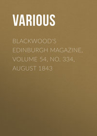
BEACON HILL BEFORE THE HOUSES
BY DAVID M. BALFOURThe visitor to the dome of the Capitol of the State, as he looks out from its lantern and beholds spread immediately beneath his feet a semi-circular space, whose radius does not exceed a quarter of a mile, covered with upward of two thousand dwelling-houses, churches, hotels, and other public edifices, does not in all probability ask himself the question: "What did this place look like before there was any house here?" When Lieutenant-Colonel George Washington visited Boston in 1756, on business connected with the French war, and lodged at the Cromwell's Head Tavern, a building which is still standing on the north side of School Street, upon the site of No. 13, where Mrs. Harrington now deals out coffee and "mince"-pie to her customers, Beacon Hill was a collection of pastures, owned by thirteen proprietors, in lots containing from a half to twenty acres each. The southwesterly slope of the prominence is designated upon the old maps as "Copley Hill."
We will now endeavor to describe the appearance of the hill, at the commencement of the American Revolution, with the beacon on its top, from which it took its name, consisting of a tall mast sixty feet in height, erected in 1635, with an iron crane projecting from its side, supporting an iron pot. The mast was placed on cross-timbers, with a stone foundation, supported by braces, and provided with cross-sticks serving as a ladder for ascending to the crane. It remained until 1776, when it was destroyed by the British; but was replaced in 1790 by a monument, inclosed in a space six rods square, where it remained until 1811. It was surmounted by an eagle, which now surmounts the speaker's desk in the hall of the House of Representatives, and had tablets upon its four sides with inscriptions commemorative of Revolutionary events. It stood nearly opposite the southeast corner of the reservoir lot, upon the site of No. 82 Temple Street, and its foundation was sixty feet higher up in the air than the present level of that street. The lot was sold, in 1811, for the miserable pittance of eighty cents per square foot!
Starting upon our pedestrian tour from the corner of Tremont and Beacon Streets, where now stands the Albion, was an acre lot owned by the heirs of James Penn, a selectman of the town, and a ruling elder in the First Church, which stood in State Street upon the site of Brazer's Building. The parsonage stood opposite, upon the site of the Merchants Bank Building, and extended with its garden to Dock Square, the water flowing up nearly to the base of the Samuel Adams statue. Next comes a half-acre lot owned by Samuel Eliot, grandfather of President Eliot of Harvard University. Then follows a second half-acre lot owned by the heirs of the Reverend James Allen, fifth minister of the First Church, who, in his day, as will be shown in the sequel, owned a larger portion of the surface of Boston than any other man, being owner of thirty-seven of the seven hundred acres which inclosed the territory of the town. His name is perpetuated in the street of that name bounding the Massachusetts General Hospital grounds. Somerset Street was laid out through it. The Congregational House, Jacob Sleeper Hall, and Boston University Building, which occupies the former site of the First Baptist Church, under the pastorship of the Reverend Rollin H. Neale, stand upon it. Next comes Governor James Bowdoin's two-acre pasture, extending from the last-named street to Mount Vernon Street, and northerly to Allston Street; the upper part of Bowdoin Street and Ashburton Place were laid out through it; the Church of Notre Dame des Victoires, formerly Freeman-place Chapel, built by the Second Church, under the pastoral care of the Reverend Chandler Robbins, and afterwards occupied by the First Presbyterian Church, the Church of the Disciples, the Brattle-square Church, the Old South Church, and the First Reformed Episcopal Church; so that the entire theological gamut has resounded from its walls; the Swedenborgian Church, over which the Reverend Thomas Worcester presided for a long series of years, also stands upon it. Having reached the summit of the hill, we come abreast of the five-and-a-half-acre pasture of Governor John Hancock, the first signer of the immortal Declaration of American Independence, extending from Mount Vernon Street to Joy Street, and northerly to Derne Street, embracing the Capitol lot, and also the reservoir lot, for which last two he paid, in 1752, the modest sum of eleven hundred dollars! It is now worth a thousand times as much. For the remainder of his possessions in that vicinity he paid nine hundred dollars more. The upper part of Mount Vernon Street, the upper part of Hancock Street, and Derne Street, were laid out through it. Then, descending the hill, comes Benjamin Joy's two-acre pasture, extending from Joy Street to Walnut Street, and extending northerly to Pinckney Street; forty-seven dwelling-houses now standing upon it. Mr. Joy paid two thousand dollars for it. At the time of its purchase he was desirous of getting a house in the country, as being more healthy than a town-residence, and he selected this localty as "being country enough for him." The upper part of Joy Street was laid out through it. Now follows the valuable twenty-acre pasture of John Singleton Copley, the eminent historical painter, one of whose productions (Charles the First demanding in the House of Commons the arrest of the five impeached members) is now in the art-room of the Public Library. It extended for a third of a mile on Beacon Street, from Walnut Street to Beaver Street, and northerly to Pinckney Street, which he purchased in lots at prices ranging from fifty to seventy dollars per acre. Walnut, Spruce, a part of Charles, River, Brimmer, Branch Avenue, Byron Avenue, Lime, and Chestnut Streets, Louisburg Square, the lower parts of Mount Vernon and Pinckney Streets, and the southerly part of West Cedar Street, have been laid out through it. Copley left Boston, in 1774, for England, and never returned to his native land. He wrote to his agent in Boston, Gardner Greene (whose mansion subsequently stood upon the enclosure in Pemberton Square, surrounded by a garden of two and a quarter acres, for which he paid thirty-three thousand dollars), to sell the twenty-acre pasture for the best price which could be obtained. After a delay of some time he sold it, in 1796, for eighteen thousand four hundred and fifty dollars; equivalent to nine hundred dollars per acre, or two cents per square foot. It is a singular fact that a record title to only two and a half of the twenty acres could be found. It was purchased by the Mount Vernon Proprietors, consisting of Jonathan Mason, three tenths; Harrison Gray Otis, three tenths; Benjamin Joy, two tenths; and Henry Jackson, two tenths. The barberry bushes speedily disappeared after the Copley sale. The southerly part of Charles Street was laid out through it. And the first railroad in the United States was here employed. It was gravitation in principle. An inclined plane was laid from the top of the hill, and the dirt-cars slid down, emptying their loads into the water at the foot and drawing the empty cars upward. The apex of the hill was in the rear of the Capitol near the junction of Mount Vernon and Temple Streets, and was about sixty feet above the present level of that locality, and about even with the roof of the Capitol. The level at the corner of Bowdoin Street and Ashburton Place has been reduced about thirty feet, and at the northeast corner of the reservoir lot about twenty feet, and Louisburg Square about fifteen feet. The contents of the excavations were used to fill up Charles Street as far north as Cambridge Street, the parade-ground on the Common, and the Leverett-street jail lands. The territory thus conveyed now embraces some of the finest residences in the city. The Somerset Club-house, the Church of the Advent, and the First African Church, built in 1807 by the congregation worshiping with the Reverend Daniel Sharp, stand upon it.
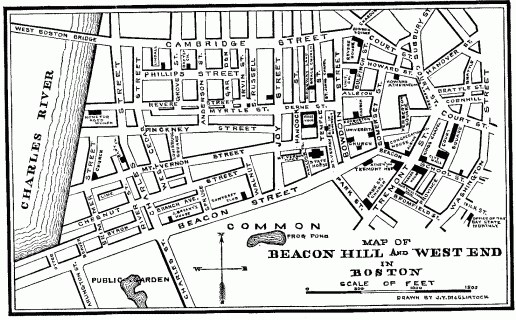
MAP OF BEACON HILL AND WEST END IN BOSTON
Bounded southerly on Copley's pasture, westerly on Charles River, and northerly on Cambridge Street, was Zachariah Phillips's nine-acre pasture, which extended easterly to Grove Street; for which he paid one hundred pounds sterling, equivalent to fifty dollars per acre. The northerly parts of Charles and West Cedar Streets, and the westerly parts of May and Phillips Streets have been laid out through it. The Twelfth Baptist Church, formerly under the pastorship of the Reverend Samuel Snowdon, stands upon it. Proceeding easterly was the sixteen-and-a-half-acre pasture of the Reverend James Allen, before alluded to as the greatest landowner in the town of Boston, for which he paid one hundred and fifty pounds, New-England currency, equivalent to twenty-two dollars per acre. It bounded southerly on Copley's, Joy's and Hancock's pastures, and extended easterly to Temple Street. Anderson, Irving, Garden, South Russell, Revere, and the easterly parts of Phillips and Myrtle Streets, were laid out through it. Next comes Richard Middlecott's four-acre pasture, extending from Temple Street to Bowdoin Street, and from Cambridge Street to Allston Street. Ridgeway Lane, the lower parts of Hancock, Temple, and Bowdoin Streets, were laid out through it. The Independent Baptist Church, formerly under the pastorship of the Reverend Thomas Paul; the First Methodist Episcopal Church, built in 1835 by the parish of Grace Church, under the rectorship of the Reverend Thomas M. Clark, now bishop of the diocese of Rhode Island; the Mission Chapel of St. John the Evangelist, which was erected in 1830 by the congregation of the Reverend Lyman Beecher, just after the destruction of their edifice by fire, which stood at the southeast corner of Hanover and (new) Washington Streets, stand upon it. Next comes the four-acre pasture of Charles Bulfinch, the architect of the Capitol at Washington, also of the Massachusetts Capitol, Faneuil Hall, and other public buildings, and for fourteen years chairman of the board of selectmen of the town of Boston, extending from Bowdoin Street to Bulfinch Street, and from Bowdoin Square to Ashburton Place, for which he paid two hundred pounds, New-England currency, equivalent to six hundred and sixty-seven dollars. Bulfinch Street and Bulfinch Place were laid out through it. The Revere House, formerly the mansion of Kirk Boott, one of the founders of the city of Lowell; Bulfinch-place Church, which occupies the site of the Central Universalist Church, erected in 1822 by the congregation of the Reverend Paul Dean; and also Mount Vernon Church, erected in 1842 by the congregation over which the Reverend Edward N. Kirk presided, stand upon it. Then follows the two-acre pasture of Cyprian Southack, extending to Tremont Row easterly, and westerly to Somerset Street, Stoddard Street and Howard Street were laid out through it. The Howard Athenæum, formerly the site of Father Miller's Tabernacle, stands upon it. Then follows the one-and-a-half-acre pasture of the heirs of the Reverend John Cotton, second minister of the First Church, extending from Howard Street to Pemberton Square, which constitutes a large portion of that enclosure. And lastly, proceeding southerly, comes the four-acre pasture of William Phillips, extending from the southeasterly corner of Pemberton Square to the point of beginning, and enclosing the largest portion of that enclosure. The Hotel Pavilion, the Suffolk Savings Bank, and Houghton and Dutton's stores, stand upon it.
Less than a century ago Charles River flowed at high tide from the southeast corner of Cambridge Street and Anderson Street across intervening streets to Beacon Street, up which it flowed one hundred and forty-three feet easterly across Charles Street to No. 61. When Mr. John Bryant dug the cellar for that building he came to the natural beach, with its rounded pebbles, at the depth of three or four feet below the surface. It also flowed over the Public Garden, across the southern portion of the parade-ground, to the foot of the hill, upon which stands the Soldiers' Monument. A son of H.G. Otis was drowned, about seventy years ago, in a quagmire which existed at that spot. It also flowed across the westerly portion of Boylston Street and Tremont Street, and Shawmut Avenue, to the corner of Washington Street and Groton Street, where stood the fortifications during the American Revolution, across the Neck, which was only two hundred and fifty feet in width at that point, and thence to the boundary of Roxbury. A beach existed where now is Charles Street, and the lower part of Cambridge Street, on both sides, was a marsh.
Less than a century ago, land on Beacon Hill was as cheap as public documents. Ministers are enjoined not to be worldly minded, and not to be given to filthy lucre. But the Reverend James Allen would furnish an excellent pattern for a modern real-estate speculator. In addition to his pasture on the south side of Cambridge Street, he had also a twenty-acre pasture on the north side of that street, between Chambers Street and Charles River, extending to Poplar Street, for which he paid one hundred and forty pounds, New-England currency, equivalent to four hundred and sixty-seven dollars, equal to twenty-three dollars per acre. He was thus the proprietor of all the territory from Pinckney Street to Poplar Street, between Joy Street and Chambers Street on the east, and Grove Street and Charles River on the west; for which he paid the magnificent sum of nine hundred and sixty-seven dollars! It was called "Allen's Farm." The Capitol lot, containing ninety-five thousand square feet, was bought by the town of Boston of John Hancock (who, though a devoted patriot to the American cause, yet in all his business transactions had an eye to profit), for the sum of thirteen thousand three hundred and thirty-three dollars; only twenty times as much as he gave for it! The town afterward conveyed it to the Commonwealth for five shillings, upon condition that it should be used for a Capitol. In 1846, the city of Boston paid one hundred and forty-five thousand one hundred and seven dollars for the reservoir lot containing thirty-seven thousand four hundred and eighty-eight square feet. In 1633, the town granted to William Blackstone fifty acres of land wherever he might select. He accordingly selected upon the south-westerly slope of Beacon Hill, which included the Common. Being afterward compelled by the town to fence in his vacant land, he conveyed back to the town, for thirty pounds, all but the six-acre lot at the corner of Beacon and Spruce Streets, and extending westerly to Charles River, and northerly to Pinckney Street, where he lived until 1635, when he removed to Rhode Island, and founded the town which bears his name.
It will thus be perceived that the portion of Beacon Hill, included between Beacon Street, Beaver Street, Cambridge Street, Bowdoin Square, Court Street, Tremont Row, and Tremont Street, containing about seventy-three acres, was sold, less than a century ago, at prices ranging from twenty-two to nine hundred dollars per acre, aggregating less than thirty thousand dollars. It now comprises the ninth ward of the city of Boston, and contains within its limits a real estate valuation of sixteen millions of dollars. Its name and fame are associated with important events and men prominent in American annals. Upon its slopes have dwelt Josiah Quincy, of ante-Revolutionary fame, and his son and namesake of civic fame; and also his grandson and namesake, and Edmund, equally distinguished; Lemuel Shaw, Robert G. Shaw, Daniel Webster, Abbott Lawrence, Samuel, Nathan, and William Appleton, Samuel T. Armstrong, Mrs. Harrison Gray Otis, J. Lothrop Motley, William H. Prescott, Charles Sumner, John A. Andrew, John C. Warren, Mrs. Sarah J. Hale, Lyman Beecher, William E. Channing, and Hosea Ballou. Lafayette made it his temporary home in 1824, and Kossuth in 1852. During the present century, the laws of Massachusetts have been enacted upon and promulgated from its summit, and will probably continue so to be for ages to come.
BRITISH FORCE AND THE LEADING LOSSES IN THE REVOLUTION
[From Original Returns in the British Record Office.]COMPILED BY HENRY B. CARRINGTON, U.S.AAt Boston, in 1775, 9,147.
At New York, in 1776, 31,626.
In America: June, 1777, 30,957; August, 1778, 33,756; February, 1779, 30,283; May, 1779, 33,458; December, 1779, 38,569; May, 1780, 38,002; August, 1780, 33,020; December, 1780, 33,766; May, 1781, 33,374; September, 1781, 42,075.
CASUALTIES.
Bunker Hill, 1,054; Long Island, 400; Fort Washington, 454; Trenton, 1,049 (including prisoners); Hubbardton, 360; Bennington, 207 (besides prisoners); Freeman's Farm, 550; Bemis Heights, 500; Burgoyne's Surrender, 5,763; Forts Clinton and Montgomery, 190; Brandywine, 600; Germantown, 535; Monmouth, 2,400 (including deserters); Siege of Charlestown, 265; Camden, 324; Cowpens, 729; Guilford Court House, 554; Hobkirk's Hill, 258; Eutaw Springs, 693; New London, 163; Yorktown, 552; Cornwallis's Surrender, 7,963.
HISTORICAL NOTES
BIRD AND SQUIRREL LEGISLATION IN 1776
"Whereas, much mischief happens from Crows, Black Birds, and Squirrels, by pulling up corn at this season of the year, therefore, be it enacted by this Town meeting, that ninepence as a bounty per head be given for every full-grown crow, and twopence half-penny per head for every young crow, and twopence half-penny per head for every crow blackbird, and one penny half-penny per head for every red-winged blackbird, and one penny half-penny per head for every thrush or jay bird and streaked squirrel that shall be killed, and presented to the Town Treasurer by the twentyeth day of June next, and that the same be paid out of the town treasury."
BARRINGTON, RHODE ISLAND
At the meeting of the town held on the fourteenth of March, 1774, James Brown, the fourth, was the first on the committee to draw up resolves to be laid before the meeting respecting the infringements made upon the Americans by certain "ministerial decrees." These were laid before a meeting held March 21, 1774, and received by the town's votes, as follows:—
"The inhabitants of this Town being justly Alarmed at the several acts of Parliament made and passed for having a revenue in America, and, more especially the acts for the East India Company, exporting their tea into America subject to a duty payable here, on purpose to raise a revenue in America, with many more unconstitutional acts, which are taken into consideration by a number of our sister towns in the Colony, therefore we think it needless to enlarge upon them; but being sensible of the dangerous condition the Colonies are in, Occasioned by the Influence of wicked and designing men, we enter into the following Resolves;
"First, That we, the Inhabitants of the Town ever have been & now are Loyal & dutiful subjects to the king of G. Britain.
"Second, That we highly approve of the resolutions of our sister Colonies and the noble stand they have made in the defense of the liberties & priviledges of the Colonys, and we thank the worthy Author of 'the rights of the Colonies examined.'
"Third, That the act for the East India Company to export their Tea to America payable here, and the sending of said tea by the Company, is with an intent to enforce the Revenue Acts and Designd for a precedent for Establishing Taxes, Duties & Monopolies in America, that they might take our property from us and dispose of it as they please and reduce us to a state of abject slavery.
"Fourth, That we will not buy or sell, or receive as a gift, any dutied Tea, nor have any dealings with any person or persons that shall buy or sell or give or receive or trade in sd Tea, directly or indirectly, knowing it or suspecting it to be such, but will consider all persons concernd in introducing dutied Teas … into any Town in America, as enemies to this country and unworthy the society of free men.
"Fifth, That it is the duty of every man in America to oppose by all proper measures to the uttermost of his Power and Abilities every attempt upon the liberties of his Country and especially those mentioned in the foregoing Resolves, & to exert himself to the uttermost of his power to obtain a redress of the grievances the Colonies now groan under.
"We do therefore solemnly resolve that we will heartily unite with the Town of Newport and all the other Towns in this and the sister Colonies, and exert our whole force in support of the just rights and priviledges of the American Colonies.
"Sixth, That James Brown, Isaiah Humphrey, Edwd Bosworth, Saml Allen, Nathaniel Martin, Moses Tyler, & Thomas Allen, Esq., or a major part of them, be a committee for this town to Correspond with all the other Committees appointed by any Town in this or the neighboring Colonies, and the committee is desird to give their attention to every thing that concerns the liberties of America; and if any of that obnoxious Tea should be brought into this Town, or any attempt made on the liberties of the inhabitants thereof, the committee is directed and empowered to call a town meeting forthwith that such measures may be taken as the publick safty may require.
"Seventh, That we do heartily unite in and resolve to support the foregoing resolves with our lives & fortunes."
JOHN ROGERS, ESQUIRE
A descendant of John Rogers, of Smithfield farm, came to America in the early emigration. Can any one give any information as to the life and death of a son, John Rogers, Jr., of Roxbury?
Answer.—John Rogers, Jr., or second, was born at Duxbury, about February 28, 1641. He married Elisabeth Peabody, and, after King Philip's War, removed to Mount Hope Neck, Bristol, Rhode Island, about 1680. He again removed to Boston in 1697; to Taunton in 1707; and to Swansea in 1710. He became blind in 1723, and died after nine days' sickness, June 28, 1732, in the ninety-second year of his age, leaving at the time of his death ninety-one descendants, children, grandchildren, and great-grandchildren. He was buried at Prince's Hill Cemetery, in Barrington, Rhode Island, where his grave is marked by a fine slate headstone in excellent preservation.
M.H.W.
PUBLISHERS' DEPARTMENT
We propose to make THE BAY STATE MONTHLY an interesting and valuable addition to every library—prized in every home—read at every fireside. We want all who sympathize with our work to express their goodwill by ordering the publication regularly at their book-seller's, or at the nearest news stand, or, better yet, remit a year's subscription to the publishers. After all, financial sympathy is what is needed to encourage any enterprise. Next in importance is the contribution of articles calculated to interest, primarily, the good citizens of this Commonwealth.
And one feature will be to develop the Romance in Massachusetts Colonial and State History. Articles of this character are specially desired. In the meanwhile, the publishers invite contributions of works upon local history, with view to a fair equivalent in exchange. New England town histories and historical pamphlets will be very readily accepted at a fair valuation.
The encouragement given to THE BAY STATE MONTHLY warrants the publishers in assuring the public that the magazine is firmly established. Many of the leading writers of the State have promised articles for future numbers.
IF you have a son settled in California, farming or cattle-raising, or among the Rocky Mountains, or in some wild mining camp exposed to every temptation, or, perhaps, on some lonely prairie farm, away from neighbors, send him THE BAY STATE MONTHLY for one year. It will come to him like a gentle breeze from his native hillside, full of suggestive thoughts of home.
In the announcement of THE BAY STATE MONTHLY, and the issue of the first number, it was perfectly understood that the enterprise was a bold piece of magazine work.
The purpose was to begin the year with the first number, and that was carried out. No apology is made for neglect of notices, whether of review, or otherwise. In fact, it was not supposed that the readers would care for editors, if, only, they had fresh matter for their perusal.