Полная версия
Meru Mountains. Hyperborea and Aryan ancestral homeland
The hymn of Ardvisura Anahita to the holy Avesta river has these lyrics:
3. “The large river, known afar, that is as large as the whole of the waters that run along the earth; that runs powerfully from the height Hukairya down to the sea Vouru-Kasha.
4. she, Ardvi Sura Anahita, who has a thousand cells and a thousand channels…
5. “From this river of mine alone flow all the waters that spread all over the seven Karshvares; this river of mine alone goes on bringing waters, both in summer and in winter.
In exalting the holy river flowing to the north into the Vourukasha Sea, the author of the hymn gives praise to those who bring it offerings on the “Hara summit,” on the “Hukairya summit” of the ancestors of the Aryans, Jima (Yama) and Paradatta.
In addition, the latitude of the Northern Uvals is 60° north and they are not only the principal divide of the Russian plains and the border between north and south, but the year there is divided into six light and six dark months. The North Star and Big Dipper there are high in the sky, and if you go down toward the sea you can also see the northern lights. A long winter is normal on these latitudes where the first snow is often in the latter half of September, and the last snow can be at the end of May, so that “the average period of safe growth of plants is equal to four months".Relevant here is Herodotus’ comment that “in all the countries named (by the Ripei Mountains) the winter is so harsh that hard frosts last eight months. During that time, even if you pour water on the ground there will be no mud, unless you light a fire… Such cold weather lasts in those countries an entire eight months, the other four months not being warm either”. Besides, it is interesting that the presence of hornless cattle in the Kirov and Perm districts confirms Herodotus’** comments about hornless bulls in the lands by the Ripei Mountains,33 which he believes is due to the harsh climate in these areas.
Turning once again to Indo-Iranian epic tradition, we should stress one more interesting detail: the hymns of Avesta, Rigveda and Mahabharata, authors of antiquity, and medieval Arab travellers all speak of riches of the Hara and Meru, Ripei (Hyperborei), and Kukaiya Mountains. Herodotus writes: “There is apparently very much gold in northern Europe. I cannot say for sure how it is extracted. According to legend, one-eyed Arimaspi people steal it from griffins.”
Is there any truth to stories about gold in the river beds, the countless treasures of these mountains if we regard the Northern Uvals as the legendary mountains? Let us look at reference literature. The Brokhaus and Efron encyclopedia says that the banks and river beds of the Mera, Volga (by Kostroma), Unzha and their tributaries have such an abundance of pyrites (fool’s gold) that it is enough lor industrial use. At the end of the 19th century peasants collected rock-ore washed up by the rivers and brought them to local factories.36 The Vurlam River flowing from the Northern Uvals to the south and its tributaries carry their waters through fields containing golden sand.
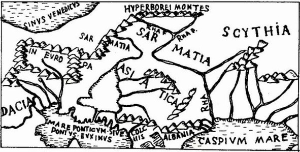
Part of the map in Ptolemaeos’ Geography, published in Rome in 1490
Relevant here is some information about the mineral resources of the Northern Uvals, the Timan mountain ridge, and other elevations in the northern European part of the Soviet Union. Many of them were most likely well known and used back in ancient times. They are sheet mica, mountain wax, tar, oilstone, rock salt, cuprous limestone, malachite, iron, copper, tin, silver, gold, precious stones such as diamond, zircon, ilmenite, spinel, amethyst, garnet, rock crystal, agate, beryl, chalcedony, amber. This list could be continued, but suffices to prove that the rivers flowing in “golden beds” and mountains “rich in precious stones” are not myths.
The mysterious holy mountains of Indo-Iranian mythology, Scythian legends and stories by ancient writers, begin to seem quite real as virtually everything said about Hara and Meru, the Ripei (Hyperborei) mountains applies to the Northern Uvals:
1. Like the legendary mountains, the Uvals extend from west to east.
2. Like these mountains, they are the border of the north and south, and are the main divide of rivers of the south and north that flow from the Uvals.
3. As in these mountains, the North Star and Big Dipper can be seen high in the sky all year.
4. As true of these mountains, the shores of the freezing White and Barents seas lie behind the Uvals. Here the polar day and the polar night are both half a year long. The northern lights can be seen on the sea shore.
5. There is only one place in the Soviet Union where the direction of the predominant air masses in the winter is clearly oriented from the northeast to the southwest. Starting out in the Kara Sea, running along the western extremity of the Northern Urals, and skimming over the Northern Uvals,40 this powerful current “is the same northeast wind invariably mentioned in connection with the Hyperborei and Ripei mountains and the related problems”.
6. Rivers flowing from the Northern Uvals do often have gold in, their beds, or beds lined with pyrite (fool’s gold) which resembles gold.
7. The Northern Uvals and the Timan mountain ridge are rich in a variety of minerals.
8. The Northern Uvals are covered with luxuriant forests and an endless variety of herbs and grasses. Fir, linden, elm, alder, and birch trees, black and red currants, Cornelian cherries, honeysuckle, rose hips, and thickets of hop grow on their slopes. These places have always been famous for abundance of animals, birds and fish: all this is mentioned in ancient and medieval literature as applied to the Ripei Mountains.
Among what has been said of holy mountains in the Indo-Iranians (the Ripei Mountains of the Scythians), and what we have not as yet linked with the Northern Uvals, there is another important detail – their altitude. Indeed, the Hara, Meru and Ripei mountains are described as very high, whereas the Northern Uvals today are no ' more than 500 meters above sea level. But it must be kept in mind that the singers of Mahabharata always described Hara and Meru as covered with forests and teeming with animals and birds.Consequently, they could not be very high.
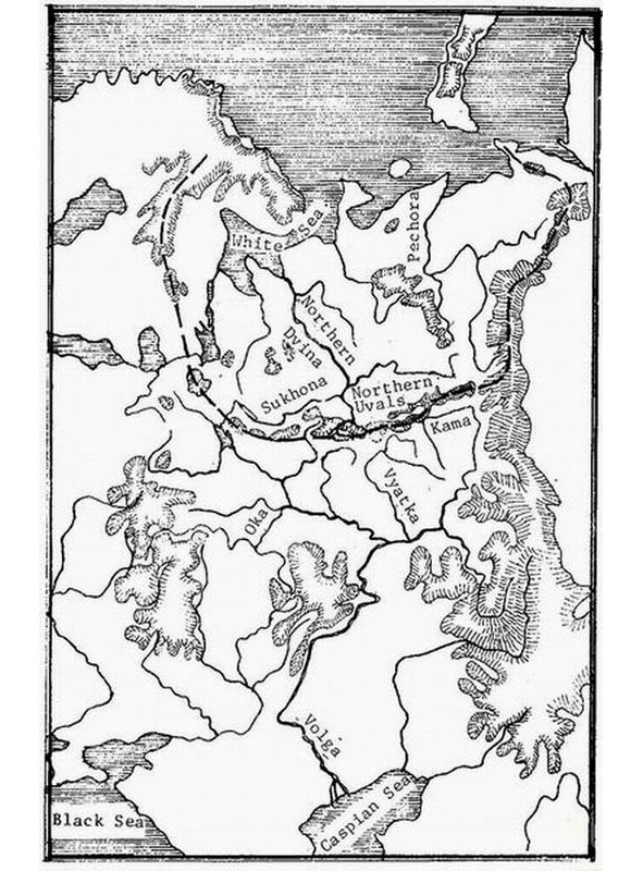
Main watershed of the northern and southern rivers of the Eastern Europe.Fig.Vinogradov G.I.
Just what are the Northern Uvals like? Let us refer to E. Murzaev’s Dictionary of Folk Geographical Terms which says that an “Uval” (hill) in the vicinity of the White Sea is a steep and tall river bank, a mountainous ridge along a valley.44 The river valleys of the Northern Uvals divide are deep and steep canyons with sides up to 80 and more meters high. The Sukhona drop on the section from Totma its month is over 49m, here it is as rapid as a mountain river.45 We know the altitude of mountains is not stable – over the millennia elevation parameters change, they become bigger or smaller. According to geological data, the ancient river valleys of the divide were 80—160 meters lower than they are today. Researchers unanimously agree that deep-set ancient valleys were caused by vertical tectonic movements of relatively large amplitude – 200—400 m46. Hence, we cannot say with certainty how high the Northern Uvals were 3,000—5,000 years ago, that is3 in Indo-Iranian antiquity, whose lower level it is impossible to chronologies precisely.
Finally, the question of cradle of the Indo-Iranian peoples is still open. Most Soviet researchers link the formation of the Indo-Iranian group with the southern half of the European part of the Soviet Union – the reaches of the lower Don. the northern Black Sea and Volga areas, etc.47 In antiquity the Uvals were indeed located north of the sources of rivers flowing on these lands, and they blocked the way to the shores of the White and Barents seas, which is probably why the legends said the mountains were impassable.
There is one more point: precisely in the watershed section of the Northern Uvals, to this day, there are many place names of intriguing similarity to Indo-Iranian words: Harino, Harovo, Harina Mountain, Harenskoye, Harinskaya, Harinovskaya; Mandara, Man-darovo, Mandra (and the Mandara mountain in the Mahabharata); Ripino, Ripinka, Ripa (and Ripei Mountains), etc. Just as interesting are river names in the region, names of still unknown origin: Indola, Indomanka, Indocap, Sindosh, Varna, Striga, Svaga, Svatka, Hvarze-nta, Harina, Pana, Kobra, Tora, Arza. (To the best’ of the author’s knowledge the possible connection between the hydronyms of this area and Indo-Iranian languages has not yet been studied). Besides, as late as the early 20th century the weaving and embroidery designs used by Russian peasant women still preserved the tradition of geometric ornamentation which originated in the most ancient Eurasian cultures of the Copper and Bronze ages, and primarily in the ceramic ornamentation of the Andronovo farming-stock breeding culture of the 17th-12th centuries B.C. which many researchers believe was an Indo-Iranian (Aryan) group.
Ah this gives reason to surmise that the holy mountains of Hara and Meru in Indo-Iranian mythology, the Hyperborei and Ripei Mountains mentioned by the Scythians and authors of antiquity, were the elevations of the northeastern European part of the Soviet Union – the Northern Uvals.
In conclusion, the Northern Uvals, especially in their eastern and central regions, remain practically unexplored by archeologists.
Hopefully, in the near future they can expect new and fascinating discoveries helping to raise the curtain covering the history of many peoples inhabiting our continent.
Where are you, Mount Meru?
In the far north, where the land is covered with snow most of the year, great and endless mountains stretch from west to east. Around their golden peaks, the sun makes its annual journey, seven stars of Ursa Major sparkle above them in the dark of night, and in the center of the universe is the North Star. From these mountains all the great earthly streams rush down, only one of them flows south, to the warm sea, and others – to the north, to the white ocean. On the tops of these mountains forests make noise, marvelous birds sing, wonderful animals live and rivers flow in the golden channels. But it wasn’t given to a mere mortal to ascend upon them, only the most daring and wise ones transgressed the limit set for people and left forever in a blessed country, the shores of which were washed by the waters of the dairy ocean. The mountains that separate the north and the “white” sea from all other lands are called the Meru Mountains, and the greatest of them is Mandara. Over the mountains Meru lasts six months day and six months – night, there the waters freeze, taking on a bizarre shape, there, in the sky above the ocean, rainbow-colored water drops sparkle, and only birds and great sages – “rishis” know the way to this land. This is the story of the distant northern country, of the ancient ancestral home of the Vedas hymns – the oldest sacred monument of the Indians. A strange, unexpected tale, it is not clear how it was born in distant, hot India, this story would have sounded if it had not lived among the most ancient legends of another southern country – Iran.
The Avesta, the sacred monument of the Iranian peoples, in its most ancient part Bundakhishna, which tells about the creation of the world, also tells about the distant northern ancestral home of the Iranians – the land of gods and ancestors, where the ranges of High Hara – Hara Berezaiti stretch from west to east with their main peak mountain Hukayrya. And above High Hara also seven stars of the Big Dipper and the North Star, set in the center of the universe, sparkle. From here, from the golden peaks originate, all the earthly rivers and the greatest of them are the pure Ardvi River, flowing with a noise into the white sea of Vourukash. Over the mountains of Vysokaya Khara, the Rapid Sun is always circling, and half a day lasts here for a year, and half a year – night. Only the brave and strong in spirit can pass these mountains and get into the happy country of the blessed, washed by the waters of the white-fronted ocean. Again these fabulous golden mountains, covered with dense forests, where the sacred plant of catfish, or haoma, grows, and from which violent rivers flow down in the golden channels. Where, how, when did the Indians and Iranians learn about the countries of cold and snow, freezing waters and the northern lights? When and where were you able to see the North Star high above your head? Scientists have been asking these questions for a century now. At the beginning of the 20th century, a book by Bal Gangadhar Tilak “The Arctic Homeland in the Vedas” appeared. He believed that the ancestors of the Indians lived in the Arctic, from where, in the 8—6 millennium BC, they left to the south under the influence of the onset of cold weather.
More than 100 years have passed since the publication of the book of Tilak, and the debate about where the Indians’ ancestral home was, where the sacred mountains eru and Hara Berezaiti rise, do not stop. But today, most scientists have come to the conclusion that the Indo-Iranian (Aryan) community was formed somewhere in the southern Russian steppes in the third – beginning of the second millennium BC. Soviet researcher B.V. Hornung suggested that the “cradle of Indo-Iranian linguistic and cultural-historical unity” was in the Middle Volga.
Scientists now know that the ancient Indo-Iranians (Aryans) were farmers and pastoralists, they sowed bread, grazed cattle and, settling in ever wider spaces, moved to the east, and west, and north, and south. And somewhere exactly in the north of their ancestral home there should have been those very sacred mountains that sang the hymns of the Avesta and the Rig Veda. But where? Ancient Greek authors also wrote about the great northern mountains, who believed that these mountains, which they called the Riphean Mountains, occupied the entire north of Europe and were the northern border of Great Scythia. So they were depicted on one of the first maps of the earth – a map of the 6th century BC Hecateus of Miletus. Herodotus wrote about the distant Northern Mountains stretching from west to east. Doubting the incredible, fantastic magnitude of the Riphean Mountains, Aristotle, nonetheless, believed in their existence and was convinced that it was from these mountains that all the largest rivers of Europe flow accept the Istros – Danubes. Behind the Riphean Mountains, in the north of Europe, the ancient Greek and Roman geographers placed the Great Northern, or Scythian, ocean.
But where exactly are the Northern Mountains – this question remains open to this day. Perhaps the creators of ancient Aryan hymns sang these ridges of the Urals, as well-known Soviet scholars G.M.Bongard-Levin and E.A. Grantovsky think? Indeed, the Ural Mountains are located in the north with respect to India and Iran; they are rich in gold and gems and stretch far to the freezing North Sea.
Yes, only the Avesta, the Veda, and ancient historians constantly repeat that the great mountains stretched from west to east, divided the land to the north and south, and the Urals – this is the border of west and east. And, finally, neither the Don, nor the Dnieper, nor the Volga originates from the Ural Mountains, and the sacred river Ardvi, flowing into the “white ocean”, is difficult to find on the spurs of the Urals. He does not divide the “earthly waters” into those that flow to the south, and those that rush to the north. But this is a distinguishing feature of the Meru Mountains and High Hara. Or did the ancient Aryans mix up east and west with north and south in their travels? Unlikely! They knew geography for their time very well, and it was more than difficult to frighten the sides of sunrise and sunset. And if neither the Veda singers, nor the creators of the Avesta, nor the ancient authors were mistaken, and did these mountains really exist in northern Europe, stretching like a bow curved towards the south, from west to east? And, probably, they have not gone anywhere in the 3—4 thousand years that separate us from the time when the ancient Aryans began their journey to India and Iran. And one thing remains – a little closer look at the map of our homeland. Here is the Black, Azov and Caspian Seas, steppes scorched by the sun; great rivers flow here from the north – the Dnieper, Don, Volga. And here is the north of the European part of the country. Cold and inhospitable White and Barents Seas, Arctic Ocean.
Many rivers flow here from south to north and among them the mighty, full-flowing Northern Dvina, which flows into the White Sea. The vast East European Plain is replete with elevations: Central Russian, Valdai, Volga… Among them, the arc consisting of the mountains of the Kola Peninsula, small elevations of the west of the Vologda Region does not immediately catch the eye. Northern Uvals and the Northern Urals, stretching from west to east for 3,700 kilometers and really separating the coast of the White and Barents Seas from the rest of Europe.
Part of this huge arc, and a very significant one, are the Northern Uvals, reaching two thousand kilometers from the west to the east, and reaching the Northern Urals. They are not high; the highest point here is only 293 meters above sea level. Of course, not the Pamir, not the Himalayas, but… it is here that the watershed of the rivers of the Caspian and White Seas is located. It is here, on the Northern Uvals, that the south of Unzha and Vetluga, the Kama and Vyatka, the rivers of the Great Volga basin, begin, and only a few kilometers from them begins its rapid movement north, to the White Sea, the South river, which merges with River Sukhona, forms the Small Northern Dvina. The second major watershed section also fits into the arc of the North Russian Uplands. This is the area of the White Lake, where the source of the high-water Sheksna flowing south, and Onega and Sukhona to the White Sea.
What is the Northern Uvals? “Damn… In the area of the White Sea,” as stated in the “Dictionary of Popular Geographic Terms” by E. M. Murzaev, “the steep and high coast of the river, mountainous ridge accompanying the valley.”
On the watershed section of the Northern Uvals, where the mountains seem to cut the rivers into southern and northern, the river valleys are deep, up to 80 meters or more canyons with steep banks. The Sukhona River (part of the small Northern Dvina) on the stretch from the city of Tot’ma to the mouth resembles a mountain river with its swiftness, because its fall here exceeds 49 meters, and in the vicinity of the village of Opoki, the banks height exceeds 80 meters. Sukhona has about 130 tributaries. The channels of the rivers flowing in the regions of the Northern Uvals are usually lined with pure orange-yellow micaceous sand, and the high steep banks surrounding them are made of orange mica sand, bright red plastic clay, red coarse-grained and yellow sandstone. How not to be born here the legends of rivers flowing in the “golden” channels, among the “golden” mountains!
Of course, they may object: “How is it, because the mountains Meru and Hara Berezaiti are Great, the highest in the world, higher than the sky and even higher than the sun, and here are some 293 meters?” This is probably due to the fact that when a person leaves the homeland, its image – where the brightest sun, the greenest grasses, the cleanest rivers and the highest mountains – lives in legends and songs. Century after century, those from the Aryans who then were to become part of the great peoples of India and Iran went farther south-east. They met on their way the highest mountains of the world, and the image of the Great Mountains of the land of their ancestors was painted with new colors. High Hara and Meru, sung by the forefathers in their sacred hymns, of course, could not be lower than the Pamirs and the Himalayas, they should have been the highest in the world, higher than the sun.
But remember: in the hymns of the Vedas and in the Avesta, the peaks of these mountains are covered with dense forests, where wonderful birds sing, where various animals live, where a wonderful hopping haoma-soma grows. It turns out that there were not so high forested areas inhabited by the beast and bird Meru and High Khara. And what about the Northern Uvals? Three quarters of them are covered with forests. And what forests! Here and spruce, and fir, and linden, and maple, and elm, and elm, and bird cherry, and alder, and birch, and aspen, and even oaks. It is at 60 degrees north latitude! Various shrubs grow in these places: red and black currants, dogrose, dogwood, honeysuckle, viburnum and hops in abundance. And in the forest meadows – magnificent forbs. As early as the beginning of the 20th century, these places were famous as rich hunting grounds, abundant in animals, birds, and fish. But it is in the summer. In winter, a snowstorm sweeps, a piercing northeast wind howls on the northern slopes of Uvals, whirls, covering everything around with flakes of snow, a blizzard. It turns out that the Aryans carried away in their new hot homeland the memory of the merciless, deadly north wind – Vayu, reigning on the slopes of the Meru Mountains. But before those who, having won the battle with the winds and snow, overcame this mountain barrier, the vast expanses of the sea opened up, fantastically frozen waters, and sparkled in their honor, illuminating the path further, the light of the northern lights.
The memory of the mountains lives in the hymns of the Veda and the lines of the Avesta, in the names of the villages and villages of the Russian North. Listen to them: Mandara – Mandarovo, Mundora – Mundorka and Mount Mandara “Vedas”; Harino – Harovo, Kharachevo – Harinskaya, Harlovo – Kharapikha, Kharkhorino – Harionovo and High Hara Avesta; Ripino – Ripinka, Ripina, Ripa and the Riphean mountains of the ancient Greeks. And also Svyatogorye, Semigorye and many villages and villages with the names of Gora (mountain) or Gorka (slide). Dvina flows into the White Sea. Or is it just a consonance of Dvina – Ardvi? Or maybe not? After all, the residents of the Kharovsky district, where the Kharovsky ridge stretches, call sand the strange word “hara”. In Sanskrit (Indo-Iranian language), “hara” is yellow, golden, orange, reddish, sunny…
Several years ago, teachers of the Russian language from around the world came to the ancient Russian city of Vologda from the University of Peoples’ Friendship named after Patrice Lumumba. And in the museum halls, looking at the patterns of embroidery and weaving made at the turn of the 19th and 20th centuries by North Russian peasant women, the young Indian said in surprise: “There is almost nothing new for me here. All this I have seen many times at home. But that shocked me the most. Explain how our embroideries could get to you?”.
The Russian North is the sacred ancestral home of the Aryans!
“The discovery of Zharnikova” – this is how modern scholars call the theory, which is proved by the candidate of historical sciences, art critic, who lives and teaches in Vologda, Svetlana Vasilyevna Zharnikova. The author of monographs and articles on the history and art of the Russian North, she is firmly convinced that in ancient time, different processes took place in the northern Polar Regions than those described by orthodox science. We asked about this and much more today the author of the discovery.
– Svetlana Vasilievna, tell us what the essence of the enormous research that you conducted is and what it crowned with!
– First, a little from the history of the issue. The fact is that the polar theory of the formation of human civilization appeared long ago, back in the nineteenth century. At the beginning of the twentieth century, the first serious studies on this topic appeared, for example, in 1903, the Indian scientist Tilak wrote his book “The Arctic Homeland in the Vedas”. Long-term studies of the Indian and Iranian holy books of the Vedas and Avesta led him to a startling conclusion: the homeland of the ancestors of the Indo-Iranians or, as they were called, Aryans was in northern Europe, somewhere near the Arctic Circle. A little later, the Russian scientist Jelachich published his book: “The Far North as the birthplace of mankind.” In it, he, in fact, deepened and developed Tilak’s ideas. The stumbling block of historians’ disputes was the question: where were the original lands of the Aryans, where is their ancestral home.