

Полная версия
Archaic roots of traditional culture of the the Russian North. (Collection of scientific articles)
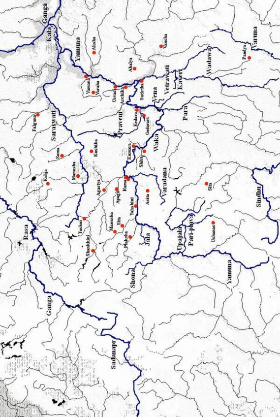
On the Voronezh River there is also another large city in the south of Russia – Lipetsk. This name is not in the Mahabharata. But there is the city of Mathura (Matura), also one of the seven sacred cities of the ancient Aryans. It was located on Kurukshetra (Kursk field) east of the Yamuna (Oka). But even now, the Matyra River flows into the Voronezh River near Lipetsk. Epos says what to capture the city of Matura Krishna first had to master the five elevations in his vicinity. But today, like many thousands of years ago five hills north of Lipetsk continue to dominate the valley.
Quite possible, that numerous information on ethnogenesis, saved by Mahabharata, will help archaeologists in identifying those archaeological cultures of Eastern Europe, which bear their conditional archaeological names so far. So according to the Mahabharata, in 6, 5 thousand BC: «all these panchals are descended from Duhshanta and Paramestkhin». Thus, the emergence of a tribe or people is confirmed, called by archaeologists the «Jenevites,» immediately before their invasion of the Volga-Oka interfluve, because Duhshanta directly preceded Samvarana.
Once Gavrila Romanovich Derzhavin wrote: «The River of times in its aspiration takes away all the affairs of people.»
We are faced with an amazing paradox, when real rivers seemed to stop the flow of time, returning to our world those people who once lived along the banks of these rivers, and their affairs. They returned our Memory to us.
Krinits (sacred reservoirs of the Aryans)
About the location of the sacred mountains Meru and Khary described in Indo-Iranian (Aryan) mythology
The location of the legendary Hara and Meru, the holy northern mountains of the Indo-Iranian (Aryan) epos and myths is one of the many riddles in Eurasian ancient history that has been troubling researchers for over a century and prompting ever more, sometimes totally contradictory, hypotheses. As a rule, they are believed to be the Scythian Ripei or Hyperborei mountains mentioned by the authors of antiquity. Over 80 years ago The Arctic Home in the Vedas, by the outstanding Indian political figure, Bal Gangadhar Tilak, launched a series of publications related to this subject in one way or another and continued to this day. The answer has never been found, as obvious from the two most recent publications – a book by G. Bongard-Levin and E. Grantovsky From Scythia to India (1983), The Ethnogeography of Scythia by I. Kuklina (1985). The two socalled Ripei Mountains locations, which the books propose, are mutually exclusive, though the authors proceed from the same ancient myths, historical sources and data.
Bongard-Levin and Grantovsky, analyzed the Avesta, Rigveda, Mahabharata, the works of Herodotus, Pomponius Mela, Plinius, Ptolemaeos, and the information provided by medieval Arabian travelers, ibn-Faldan, ibn-Batuta, and concluded that the geographical characteristics, repeated without exception in every source, are factual a/id indicate that the Ripei Mountains, Hara and Meru were the Urals, since only they possess nearly all the specific features attributed to the holy northern mountains: high altitude, natural resources, proximity to northern seas, etc.
Kuklina, the author of The Ethnogeography of Scythia, disagrees entirely, and argues that «it is apparently necessary to first distinguish the concept of the mythical northern mountains from that of mountains north of Scythia where many rivers began. Both of them were named Ripei. However there is no doubt that only the latter mountains can be localized, whereas the former, connected with the far north and Hyperborei, should be sought for in the myths of Indo-lranian peoples». Kuklina backs up her conclusions with a large number of comments by ancient authors – Pseudo Hippocrates, Dionisius, Eustaphius, Vergilius, Plinius, Herodotus, etc. – about the northern mountains called Ripei. She then cites, from Bongard-Levin and Grantovsky, examples of amazing similarities between Scythian polar concepts and ancient Indian and ancient Iranian «Arctic» tradition.
Kuklina draws the following conclusion: the northern mountains and the entire
«Arctic» cycle are merely a myth, a retelling of what was learned from native Siberians. She feels the Ripei Mountains were actually the Tien Shan Mountains, as they are the only latitudinal watershed range in this part of Eurasia, are very high, and are north of India and Iran, etc.
Here it is necessary to single out the following groups of information about the Ripei Mountains, Hara and Meru, identical in the writings of medieval Arab travelers, authors of antiquity, in Scythian and ancient Iranian mythological tradition. This information is also noted by the authors of From Scythia to India and the author of The Ethnography of Scythia.
1. The Ripei Mountains, Hara and Meru extended from the west to the east, separating north from south;
2. In the north, beyond the Ripei Mountains, Hara and Meru, is the Arctic or Kronian, or Dead or Milk Ocean, or the huge Vourukasha Sea that receives the rivers flowing from these mountains to the north;
3. The Ripei Mountains, Hara and Meru are a divide, as they separate rivers flowing to the south and flowing to the north;
4. From the summits of the Hara, Meru and Ripei Mountains, spring a) the heavenly Gang, b) holy Ratha, c) Rusiya River, d) all of Scythians big rivers except the Ister-Danube;
5. In these northern lands one can always see high in the sky the North Star and the Big Dipper;
6. The day there lasts half a year and the night half a year, and in the winter a cold northeast wind blows, causing much snow;
7. Rivers originating in these mountains have golden beds, and the mountains themselves contain countless riches;
8. The mountains are covered with forests, they abound with animals and birds and are very high and impassable;
A land of happiness lies beyond the Ripei Mountains, Hara and Meru.
Kuklina does not believe that the northern mountains were the Urals, and has reason to note essentially insurmountable contradictions: ancient writers indicate unequivocally that the Ripei Mountains extended latitudinal, which is not true of the Ural Mountains; the Ural Mountains are located to the east or northeast of Scythia which was in the Black Sea area, certainly not to the north; the Ural Mountains are not the divide from which Scythian rivers emerged.
It is hard to disagree with this. But while Kuklina finds contradictions in the hypothesis of the authors of From Scythia to India, she also faces practically irreconcilable contradictions. First, although the Tien Shan Mountains extend latitudinal, they are definuely not the divide of rivers flowing into northern and southern seas. True, the source of the great Syrdarya is in these mountains, but it flows into the Aral Sea which can hardly be called Lhe Arctic or Dead Ocean. As for the other rivers in Central Asia (those flowing to the north), none of them takes its waters to the sea, which does not in any way correspond to Indo-Iranian poetic mythical or Scythian tradition. Although the divide of Central Asian and Kashgarian rivers is in the Tien-Shan Mountains, those flowing south do not reach the sea, but are all tributaries of the lone Tarym River that disappears in the Takle-Makan desert, an unlikely place for rivers with golden beds, a six-month day and six-month night. The North Star and Big Dipper are not high in the sky, and many more things are lacking that apply specifically to the northern mountains. Thus, we are confronted with the paradox: the Urals are not the Ripei Mountains of the Scythians or the holy Hara and Meru of the Indo-Aryans, but neither does the Tien-Shan Range tally with the traditional descriptions. The author of The Etknogeography of Scythia believes that the Northern mountains were only a myth: ".there is no doubt about it that the Indo-Iranians did not live in areas near the Polar Circle but obtained realistic information about polar phenomena mixed with legends about the northern mountains (italics) and the gods from their northern neighbours.»
However, it is highly improbable that different peoples originated a myth with quite concrete geographical characteristics – length, latitudinal orientation, wind direction, long winter, northern lights, etc. – that were not based on reality. This is the entire stranger in view of the following circumstances: according to Mahabharata and Rigveda the country of Harivarsha was in the north and was the abode of Rudra-Hara. «The stylite with blond braids», the «holy sovereign Hari-Narayana, boundless Purusha, radiant eternal Vishnu, the brown bearded Ancestor of all creatures.» The north was the home of the god of wealth, Kubera, of the «seven Rishi» who were the sons of the creator Brahma. These brothers were revered as seven Prajapati – the «rulers of all creatures», the forefathers and ancestors embodied in the seven stars of the Big Dipper. The north was also the location of the «pure, wonderful, meek, desirable world» where «well-wijhing people are reborn», and in general «the northern part of the world, more beautiful and pure than any other,» and «the day of the gods» is the sun’s route to the north.
It seems Kuklina is far from correct when she asserts that the northern mountains of the Indo-Iranian epos were totally fictitious and that there is no point in looking for them on the map. However, it is also hard to agree with the authors who claim the Hara and Meru Mountains were the Urals; the concept holds too many contradictions.
No doubt it is necessary to look once again at the ancient sources, especially since more and more researchers are convinced that the authors of antiquity must and should be believed. For instance, M. Agbunov, on the basis of paleo-graphic data on changes in the Black Sea coastline, concludes that «the works of ancient authors are, as a rule, a reliable source and merit more attention and trust… it should be stressed that most of the concrete historical and geographical descriptions by ancient authors are absolutely correct.» In this case we can use such an authoritative source as Ptolemaic» Geography, specially since it is referred to by the authors of From Scythia to India and the author of The Ethnogeography of Scythia.
But because the text, as we saw earlier, can be interpreted in different ways to prove contradictory conceptions, let us look at Ptolemaeos’ map, or rather at that part of Geography (published in Rome in 1490) where a mountain range is shown in the north and called Hyperborei Monies.
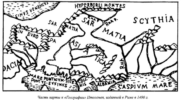
Part of the map of Geography by K. Ptolemy 1490
This was the part in Ptolemaeos’ work that Bongard-Levin and Grantovsky called a mistake, claiming that Ptolemaeos put non-existent mountains in the north.
When we compare the map of the European part of the Soviet Union with Ptolemaeos’ map, we can see genuine geographical sites such as the Baltic, Black, Azov and Caspian seas, and the Volga running into the Caspian and called Rha, (Called Ra by some authors) the ancient Avesta name. We also see all the more or less significant elevated areas up to the Southern Urals, which are separated by a considerable distance from the Hyperborei Montes that Ptolemaeos marked in the north and that extend latitudinally, and that are the starting point of two sources of the holy river of the ancient Iranians-Rahi. This map indicates that Ptolemaeos, and probably geographers of antiquity long before him, make a distinction between the Hyperborei and the Ripei mountains, and the Urals.
Was Ptolemaeos correct or incorrect, were there such elevations in the north that were the starting point of the Volga (Manu authors note that in ancient times people did not know the true source of the Volga. See V. M. Beilis. Al-Idrisi…) and Kama rivers? The map of the USSR shows objectively that there were such elevations-the Northern Urals (Hills). Located in the northeastern European part of the Soviet Union they extend 1,700 kilometers from west to east, and through the Timan mountain ridge combine into a single system with the Northern Urals (In Ptolemaeos Geographical Guidebook §5 gives the coordinates of the Hyperborei Monttanian in northen Europe (63—64° northern latitude), that is, the latitude of the Norhtern Urasls).
One of the Soviet Union’s most prominent geomorphologists, Yu. Meshcheryakov, wrote the following in his fundamental study, Relief of the USSR, published in 1972: «The world divide that borders the Arctic Ocean basin is farthest away from the ocean to the south, deep inside Eurasia, the Asian part of the USSR. The maximum distance from the ocean to the divide -3,000—3,500 kilometers – is marked on the meridians of Baikal-Yenisei… Going through the Urals, the dividing line suddenly approaches the coast, and with inike Northern Uvals it is only 600—800 kilometers from the shore». The author goes on to say that the Northern Uvals are the main divide of northern and southern seas in the Russian plains. While he calls them the «principal orthographically anomaly of the Russian plains», he notes the paradox that «the highest elevations (Middle Russia, Volga region) are in the southern part of the plains, they are not the main dividing lines, yielding the role to the insignificant, relatively small Northern Uvals.»
Meshcheryakov also points out that unlike most of the Russian plains’ elevations which are oriented meridianally, «The origin of the inverse morphostructure of the Northern Uvals remains unclear. This elevation does not have a meridianal, but a sub-latitudinal direction».
He writes of a «close, organic tie between’ the undulating deformations of the Urals and Russian plains,» and stresses that "…the Timan mountain ridge starts from the orographical junction of the «Three Rocks» (Konzhakovsky Rock- 1,569 meters, Kosvinsky Rock-1,519 meters and Denezhkin Rock- 1,492 meters). This wide and elevated section of the Urals is on the same latitude as the Northern Uvals and joins them forming a single latitudinal elevated zone». The work also notes the same origin of the Northern Uvals, Galichskaya and Gryazovetsko-Danilovskaya elevations, or those latitudinal elevations in the northeastern European part of the Soviet Union that unite into a single bulge the elevations of Karelia, the Northern Uvals and Northern Ural mountains, that is, the part of the range that runs in a north-northeastern direction.
Thus, the Northern Uvals – the main divide of northern and southern rivers, the basins of the White and Caspian seas – are the precise location Ptolemaeos cited for the Hyperborei (or Ripei) Mountains, the source of the holy river Rha.
However, according to the same Avesta tradition, its source is in the mountains of High Hara – Hara Berezaiti, on the «golden summit of Hukairya». Of interest in this connection is what Al-Idrisi (12th century) wrote about the Kukaiya Mountains that he places in the far northeast of the oecumene and «that could be connected with the Ripei Mountains noted by ancient geographers, primarily Ptolemaeos», and the Hukairya Mountains of Avesta. Dwelling on the Kukaiya Mountains, the source of the Rusiya River, Al-Idrisi points out that: «Six big rivers flow into the aforementioned Rusiya River; their sources are in the Kukaiya Mountains. These are big mountains extending from the Black Sea to the edge of the inhabited Earth… They are very big mountains; no one can climb them because of the extremely cold weather and the constant abundance of snow on their peaks.»
If we accept the Ripei (Hyperborei) and Kukaiya mountains as the Northern Uvals, the six rivers are readily found. The Volga (Rusiya) is indeed the drainage point of six rivers that flow from the Uvals – the Kama, Vyatka, Vetluga, Unzha, Kostroma and Sheksna (Yu. Meshcheryakov stresses the ancient origin of the river network at the divide).
Thus, if we regard the Kama as the source of the Volga, as was the case in ancient tradition, then the Volga (Rha) of Ptolemaeos and Avesta, indeed, begins in the Northern Uvals (especially since the actual sources of the Volga are in the Valdai elevation which is included in the southern part of the bulge described).
They are also the starting point of the biggest river in the Russian North -the great and deep Northern Dvina which runs into the White Sea and has over a thousand tributaries. One of them, the Emtsa River, does not freeze over in the winter due to the hot springs in its canyon.
The hymn of Ardvisura Anahita to the holy Avesta River has these lyrics:
«The large river, known afar, that is as large as the whole of the waters that run along the earth; that runs powerfully from the height Hukairya down to the sea Vouru-Kasha.
She, Ardvi Sura Anahita, who has a thousand cells and a thousand channels.
«From this river of mine alone flow all the waters that spread all over the seven Karshvares; this river of mine alone goes on bringing waters, both in summer and in winter. (Aban yast)
In exalting the holy river flowing to the north into the Vourukasha Sea, the author of the hymn gives praise to those who bring it offerings on the «Hara summit,» on the «Hukairya summit» of the ancestors of the Aryans, Jima (Yama) and Paradatta.
In addition, the latitude of the Northern Uvals is 60° north and they are not only the principal divide of the Russian plains and the border between north and south, but the year there is divided into six light and six dark months. The North Star and Big Dipper there are high in the sky, and if you go down toward the sea you can also see the northern lights. A long winter is normal on these latitudes where the first snow is often in the latter half of September, and the last snow can be at the end of May, so that «the average period of safe growth of plants is equal to four months».
Relevant here is Herodotus’ comment that «in all the countries named (by the Ripei Mountains) the winter is so harsh that hard frosts last eight months. During that time, even if you pour water on the ground there will be no mud, unless you light a fire… Such cold weather lasts in those countries an entire eight months, the other four months not being warm either».
Besides, it is interesting that the presence of hornless cattle in the Kirov and Perm districts confirms Herodotus’ comments about hornless bulls in the lands by the Ripei Mountains, which he believes is due to the harsh climate in these areas. (Report about hornless Perm cattle that give high-fat milk (4.7 percent) and fare well in frosts and With amounts of food).
Turning once again to Indo-Iranian epic tradition, we should stress one more interesting detail: the hymns of Avesta, Rigveda and Mahabharata, authors of antiquity, and medieval Arab travellers all speak of riches of the Hara and Meru, Ripei (Hyperborei), and Kukaiya Mountains. Herodotus writes: «There is apparently very much gold in northern Europe. I cannot say for sure how it is extracted. According to legend, one-eyed Arimaspi people steal it from griffins.»
Is there any truth to stories about gold in the river beds, the countless treasures of these mountains if we regard the Northern Uvals as the legendary mountains? Let us look at reference literature. The Brokhaus and Efron encyclopedia says that the banks and river beds of the Mera, Volga (by Kostroma), Unzha and their tributaries have such an abundance of pyrites (fool’s gold) that it is enough lor industrial use. At the end of the 19th century peasants collected rock-ore washed up by the rivers and brought them to local factories.
The Vurlam River flowing from the Northern Uvals to the south and its tributaries carry their waters through fields containing golden sand.
Relevant here is some information about the mineral resources of the Northern Uvals, the Timan mountain ridge, and other elevations in the northern European part of the Soviet Union. Many of them were most likely well known and used back in ancient times. They are sheet mica, mountain wax, tar, oilstone, rock salt, cuprous limestone, malachite, iron, copper, tin, silver, gold, precious stones such as diamond, zircon, ilmenite, spinel, amethyst, garnet, rock crystal, agate, beryl, chalcedony, amber, etc. This list could be continued, but suffices to prove that the rivers flowing in «golden beds» and mountains «rich in precious stones» are not myths.
The mysterious holy mountains of Indo-Iranian mythology, Scythian legends and stories by ancient writers, begin to seem quite real as virtually everything said about Hara and Meru, the Ripei (Hyperborei) mountains applies to the Northern Uvals:
1. Like the legendary mountains, the Uvals extend from west to east.
2. Like these mountains, they are the border of the north and south, and are the main divide of rivers of the south and north that flow from the Uvals.
3. As in these mountains, the North Star and Big Dipper can be seen high in the sky all year.
4. As true of these mountains, the shores of the freezing White and Barents seas
lie behind the Uvals. Here the polar day and the polar night are both half a year long. The northern lights can be seen on the sea shore.
5. There is only one place in the Soviet Union where the direction of the predominant air masses in the winter is clearly oriented from the northeast to the southwest. Starting out in the Kara Sea, running along the western extremity of the Northern Urals, and skimming over the Northern Uvals, this powerful current «is the same northeast wind invariably mentioned in connection with the Hyperborei and Ripei mountains and the related problems».
6. Rivers flowing from the Northern Uvals do often have gold in, their beds, or beds lined with pyrite (fool’s gold) which resembles gold.
7. The Northern Uvals and the Timan mountain ridge are rich in a variety of minerals.
8. The Northern Uvals are covered with luxuriant forests and an endless variety of herbs and grasses. Fir, linden, elm, alder, and birch trees, black and red currants, Cornelian cherries, honeysuckle, rose hips, and thickets of hop grow on their slopes. These places have always been famous for abundance of animals, birds and fish: all this is mentioned in ancient and medieval literature as applied to the Ripei Mountains.
Among what has been said of holy mountains in the Indo-Iranians (the Ripei Mountains of the Scythians), and what we have not as yet linked with the Northern Uvals, there is another important detail – their altitude. Indeed, the Hara, Meru and Ripei mountains are described as very high, whereas the Northern Uvals today are no ' more than 500 meters above sea level. But it must be kept in mind that the singers of Mahabharata always described Hara and Meru as covered with forests and teeming with animals and birds.
Consequently, they could not be very high.
Just what are the Northern Uvals like? Let us refer to E. Murzaev’s Dictionary of Folk Geographical Terms which says that an «Uval» (hill) in the vicinity of the White Sea is a steep and tall river bank, a mountainous ridge along a valley.
The river valleys of the Northern Uvals divide are deep and steep canyons with sides up to 80 and more meters high. The Sukhona drop on the section from Totma its month is over 49m, here it is as rapid as a mountain river.
We know the altitude of mountains is not stable – over the millennia elevation parameters change, they become bigger or smaller. According to geological data, the ancient river valleys of the divide were 80—160 meters lower than they are today. Researchers unanimously agree that deep-set ancient valleys were caused by vertical tectonic movements of relatively large amplitude – 200—400 m. Hence, we cannot say with certainty how high the Northern Uvals were 3,000—5,000 years ago, that is3 in Indo-Iranian antiquity, whose lower level it is impossible to chronologies precisely.
Finally, the question of cradle of the Indo-Iranian peoples is still open. Most Soviet researchers link the formation of the Indo-Iranian group with the southern half of the European part of the Soviet Union – the reaches of the lower Don. the northern Black Sea and Volga areas, etc. In antiquity the Uvals were indeed located north of the sources of rivers flowing on these lands, and they blocked the way to the shores of the White and Barents seas, which is probably why the legends said the mountains were impassable.