

Полная версия
Archaeology of the Indo-European Fatherland
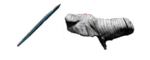
The fact that the world of the Paleolithic man was much more complex and spiritually richer than we had previously imagined evidenced by the highly developed and specialized stone industry, and complex constructions of bone-sod houses, and thousands of drilled polished beads, spears and bracelets from mammoth tusks in the graves of Sungir, musical instruments and statues of Mezin and much more.
As noted earlier, already in the Upper Paleolithic we meet with a peculiar contrast of red and white: the whiteness of the bones was contrasted with the saturated color of the engraved ornaments worn by red ocher. In the graves of Sungir, the bottom was sprinkled with white matter (chalk or lime) and «already on the white layer of the grave densely showered with bright red ocher.
«Researchers noted what exactly red color played a huge role in cult rites and aesthetics of this period. Red dyes were used even in mustier (up to 50 thousand BC), and for a very long time there was a belief that ancient people used only natural dyes. As a result of research, it was found that by firing glandular nodules in different modes, red dyes of various shades were obtained already in the Upper Paleolithic.
N. D. Praslov writes: «… in general, it can be stated that more than 20 thousand years ago primitive people used a wide range of dyes, at least four primary colors: white, ocher, red and black. Especially rich colors are red paint.»
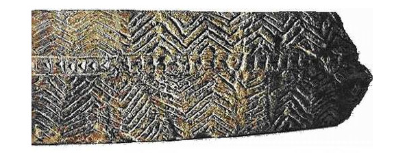
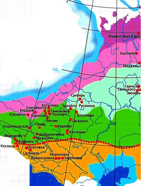
It should be noted that in the textile decor of many peoples of Eurasia, such a traditional combination of red and white survived to the 20th century. And this is especially characteristic of East Slavic ornamentation in general and North Russian, in particular. It is in such a strict and ancient red-white color scheme that the ornaments of «a charming complex of swastika signs in the patterns of North Russian skilled craftswomen» are made, in which, according to V. A. Gorodtsov, «a vivid memory of the most ancient universal symbols is hiding.» – the researcher exclaims. And this is not surprising. Having studied the Mezin Upper Paleolithic site, I. G. Shovkoplyas believed that the commonality of ornamental complexes indicates the affinity of the groups using these complexes. He believed that the population of Kostenki II on the Don, the Mezinsk site in the Dnieper and the East Siberian sites of Malta and Buret was closely related. He’s writing: «… a very distant resettlement of certain groups of East European Late Paleolithic population, possibly also originating from the Middle Dnieper basin (the Middle Dnieper ethnocultural region), probably, the location of Malta and Buret sites in Eastern Siberia should also be explained, extremely close and even identical in many manifestations of their material and spiritual culture (flint tools, bone products, character of dwellings, etc.) with sites of the Middle Dnieper basin, first of all with the same Mezinsk. Not excluded that the inhabitants of the sites of the
Mezin culture in the Middle Dnieper basin, on the one hand, and the named Siberian sites – on the other, had a common origin and even for some time constituted one population group at an early stage of their history. " 26 To the cited above, it should also be added that the inventory of the Upper Paleolithic Buzovaya site, located 175 km. from the Arctic Circle, which is 25—29 thousand years away from us, has much in common with the complex of the lower layer Kostenki I, 12 on the Don and dates back to the same time that, according to the conclusions of I. G. Shovkoplyas testifies to the genetic kinship of human groups that left these sites. At present, for most researchers, the population of the Urals at the end of the Mologo-Sheksna time seems indisputable.
Ornaments Kostenki II on the Don
Ornaments Malta Buret
Ornaments Kargopol
The exceptional development and perfection of the norms of ornaments, sculptures, relief’s dating back to this time convince that their roots should be sought in the more ancient Mousterian era, in that period of the Mikulinsk interglacial (130—70 thousand years ago), when human groups already mastered the Pechora basin and the coast of the Arctic Ocean and when the climate of the north of Eastern Europe did not differ from the modern climate of England and Southern Germany.
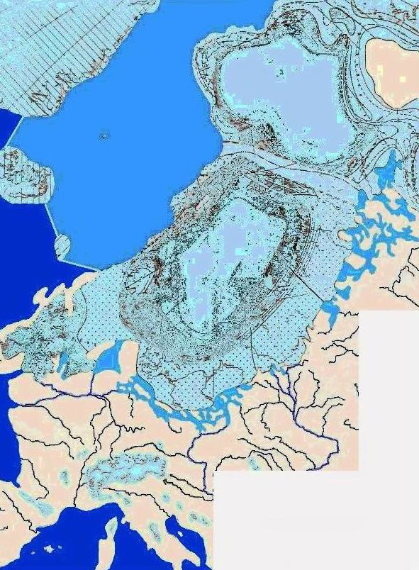
Ice sheet during the maximum stage of the Valdai glaciation The discovery in the last decades of first-class Paleolithic monuments in the north of the European part of our country (Bear Cave is located at 65° N), with lots of flint inventory and even wall painting, is an outstanding event.
It shows once again that in the ancient Stone Age human groups widely populated the north of Eastern Europe, those territories of the future Arkhangelsk, Vologda, Kostroma, Vyatka regions and the Komi Republic.The warm young Sheksninsky time was replaced about 20—18 millennia ago by a sharp cooling when the overgrown Scandinavian ice sheet reached its maximum development. The data of modern science indicate that the limit of the distribution of the Valdai glaciation went in the latitudinal direction from Vilnius to Smolensk, and then to the northwest to the Rybinsk Reservoir, Lake Kubensky and Nyandoma. Further to the northeast, the border is not reliably established.
At this time, in the territory of England and Ireland, free of glacier, stretched the tundra and subarctic meadows. Birch woodland (park tundra) was common in Western Europe, and the woodlands with birch and birch-pine forest stands occupied most of Central Europe and then a relatively narrow strip along the coast of the future Baltic Sea, and then Baltic glacial lake, to the northeast. Real forests or as they are called «typical forest boreal formations», in the western and middle parts of Europe at that time there were very few and they were mainly in the valleys of large rivers and intermontane basins.
Within the Russian plain, forests occupied, unlike Western Europe, a large area in the form of a wide strip crossing it in the direction from the southwest to the northeast. These were birch, pine, spruce and fir forests.
Paleogeographers note that: «in a number of areas there already existed forests with the participation of broad-leaved species such as oak and elm …vegetation of the steppe type was widespread in the southern part of the Russian Plain. It is interesting to note that during the maximum of the Valdai glaciation, when almost the entire territory of England was covered with a glacier, and habitable sections were tundra and arctic meadows, primitive people and animals such as the wolf, cave bear, woolly rhinoceros, reindeer, bull and mammoth lived only 50 km. from the edge of the glacier. At the same time, meadow steppes with spruce-birch and pine forests were widespread in the Upper Volga basin. In the Oka basin, during the maximum glaciation, spruce-pine forests of the north-taiga type were noisy. In the area of the village of Pokrovskaya on the Puchka River (near Lake Kubensky, at 60°N), directly at the edge of the glacier, about 38 species of flowering and spore plants grew and the woodland consisted of birch, spruce, larch. Need to mark, that the actual tundra type of vegetation in Eastern Europe was a relatively narrow strip along the border of the Scandinavian ice sheet. But in Central Europe the tundra occupied, apparently, «the entire strip between the Scandinavian ice sheet in the north and the Alpine glacier in the south, and in the Atlantic part their distribution was even greater.»
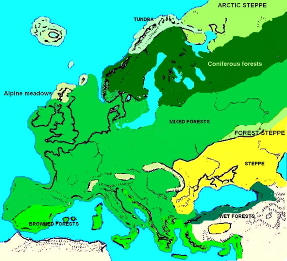
If during the period of the maximum stage of the Valdai glaciation (20—18 thousand years ago) almost the entire territory of Western Europe, with the exception of the south-west of France, the upper reaches of the Danube and the foothills of the Eastern Carpathians, was occupied by subarctic meadows and tundra with birch and deciduous woodlands, then in Eastern Europe from the upper Dniester began a wide strip of meadow steppes with pine, deciduous and birch forests, passing through the Pripyat basin, Middle Dnieper, the middle course of the Oka. Expanding in the direction from southwest to northeast, in the northwest it reached the Upper Volga (in the Yaroslavl region) and the middle Vychegda in the north. The entire southeast of Eastern Europe at that time was occupied by cereal steppes, reaching in the northeast up to 55° N, in a number of areas there were forests with the participation of broad-leaved species such as oak and elm. Thus, plant zones were located in the submeridian direction, «sharply different from basically the breadth of zonality of the modern vegetation cover of Eurasia, „that“ can be considered as one of the most characteristic features of the nature of Europe in the era of glaciation.»
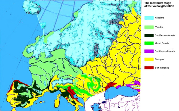
Vegetation. Maximum Valdai Glaciation
In most of the European territory of our country, there was no glacier during the maximum of the Valdai glaciation. And of course, in the presence of those natural conditions that existed then, it is unlikely that the population left these lands. Experts believe that during the peak of the Valdai glaciation during the period of the greatest cooling, the outflow of the population from the territories bordering the edge of the glacier went «south to the mountains, south-west to the territory of the Central Massif of France and along the Sudeten and Carpathians towards the Russian Plain», with its meadow steppes and forests, and hence with an abundance of food. However, it should be noted that the entire territory of the Baltic States, Northern Belarus, the North-West of Smolensk, Leningrad, Novgorod and a significant part of the Tver regions were covered with glacier and their settlement occurs only at the end of the Late Glacial, at the turn of the Paleolithic and Mesolithic. It remains to be assumed that with climate change worsening, and then with the advent of the glacier, the population who left these territories, to a large extent advanced to the east of the Russian Plain and the Urals, and part of it went to the Trans-Urals, to the lands of Western Siberia and further east, up to Altai. Maybe, it was then that the division of the unified boreal parent language into three independent branches occurred – the Early Indo- European language, which continued to develop in Eastern Europe, the Early Uralic language, which was formed in the Trans-Urals and early Altai language.
Paleolithic sites in Eastern Europe
Mesolithic
About 13.5 – 13 thousand years ago, global warming began and 12 millennia ago, a new postglacial time begins – the Holocene. In the north of the European part of our country, its beginning was noted, as in Western Europe, by a transition zone, an important property of which was the presence of sharp climatic fluctuations: warming belling (12,400 – 12,000 years ago), cooling of the average Dryas (12,000 – 11,800 years ago), warming Allered (11,800 -11,000 years ago), cooling of the Late Dryas (11,000 – 10,300 years ago), Polovtsian warming (10,300
– 10,000 years ago), Pereyaslav cooling (10,000 – 9,500 years ago).
Already 11,900 – 10,300 years ago, summer temperatures in Europe were approaching modern. 31 This time was marked in Eastern Europe by a significant reduction in the area of the glacier. So already about 13600 years ago, the Klimetsky island on Lake Onega was abandoned by a glacier, and the Luga glacier zone was formed about 13,200—1,300 years ago. At 8 kb the eastern border of the glacier was on the border of Karelia and Finland.
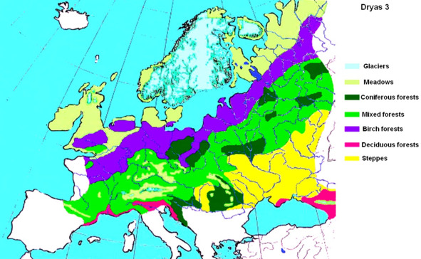
Dryas vegetation
Subsequently, there was an increase in heat supply, up to the so-called Holocene climatic optimum, which came about 8 thousand years ago. Already 12
thousand years ago, on the site of the current swamps of the Yaroslavl and Leningrad regions, spruce, birch and pine forests grew and after 2—3 millennia – linden and elm. During the late glacial warming, birch, pine and spruce forests spread on the territory of the Russian Plain; in the south of the Pskov region there were thermophilic plants, for example, sea buckthorn. The White Sea has been freed from mainland ice and in the next millennium it was connected with the Barents Sea by two straits. In the north of the Pechora lowland 10—9 thousand years ago, woody vegetation developed the territory, moreover, «it was established that the degradation of the last ice sheet of the Pechersk Lowland, as well as of the entire north-east of the European territory of the USSR, occurred in an unusual way, fundamentally different from the degradation of the Scandinavian ice sheet.»
Researchers suggest that the destruction of the ice sheet was accompanied and may have been caused by processes of a seismic nature, catastrophic earthquakes. The Baltic is getting warm. On the island of Gotland over a period of time from 9700 to 9000 years ago, temperatures increased by 15° C, reaching modern values. Since the end of 7 thousand BC forests of the northern taiga appearance has advanced to the Barents Sea, the tundra on the continent has completely disappeared. In the place of modern middle taiga, southern taiga forests appeared with the participation of oak, elm, maple, and hazel. In relation to the current situation, the northern border of the middle taiga has advanced 450—550 km to the north. Broad-leaved forests in the west of the Russian Plain have grown to a strip width of 1200—1300 km. in the meridional direction. Dark coniferous spruce taiga occupied an area three times smaller than at present. Between 8,200 and 6,000 years ago, deciduous forests advanced south, and the zone of real steppes was limited only to a narrow strip of the Black Sea coast.
In the forest belt of Eastern Europe in the Holocene begins a new period of the Middle Stone Age or Mesolithic (10—5 thousand years BC) – the time of settlement and development of the northern and north-western territories. Ice liberation took place in many ways. Modern researchers suggest that there was an influx of population from the south-west from the Volga-Oka and Baltic-Dnieper regions.
This is not unexpected after all; people followed a long beaten path. Recall that analyzing the inventory of the Upper Paleolithic sites of the Dnieper (Mezin culture), Don (Kostenki), Siberia (Malta and Buret) and Pechora (Buzovaya site), the researchers suggested a genetic relationship between the human groups that left these sites. In addition, significant areas of the north of the Russian Plain, located between the eastern border of the glacier (Mologa blade) and the Ural Range, covered and at the peak of the glacier with mixed forests and meadow grass steppes, hardly abandoned by humans. In the Mesolithic era with improved climatic conditions, with the increase in the zone of broad-leaved forests, the population in these territories should naturally increase, because it is broad-leaved forests that «have high biological productivity and extremely favorable conditions for the extraction of plant and animal food».
During the Mesolithic, almost the entire territory of the Leningrad, Novgorod, Tver, Yaroslavl, Kostroma, Vologda regions, Karelia and a significant part of the Arkhangelsk region were in the subzone of deciduous forests.
Holocene vegetation
In the Mesolithic era, man develops the Arctic. A large number of sites of this time were identified in the basin of the Northern Dvina, Vychegda, Pechora.
Already 12—11 millennia ago, human groups mastered the Arctic coast of the Kola Peninsula. At the turn of 7—6 BC Mesolithic settlements appear in the West Siberian Arctic, in Taimyr, in the Lena, Indigirka and Kolyma basins. Mastering new territories, tribes or groups of tribes transferred their labor skills, cultural traditions, rituals and rituals that developed long before the Mesolithic period to great distances.
In the northern part of Eastern Europe, 8900—8300 years ago, «areas are distinguished that are separated by a line from the Kola Peninsula to the Urals, to a latitude of 60° N and further to Lake Baikal. To the north of this line during the indicated period it was warmer (in places more than 5° C), than now, south is colder.»
The same situation persists in the following time 4 – 3 thousand BC, when thermophilic vegetation has spread widely, and climate warming and mitigation «was not observed everywhere, but in a number of regions of the northern hemisphere, approximately between 45 and 70° north latitude, south was a relative cooling strip».
It was during this period, called the Atlantic, that a maximum of broad-leaved, which appear in the north of Eastern Europe already in the second half of the boreal, i.e. in 8 thousand BC.
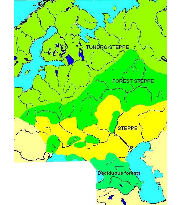
Natural areas in the Paleolithic
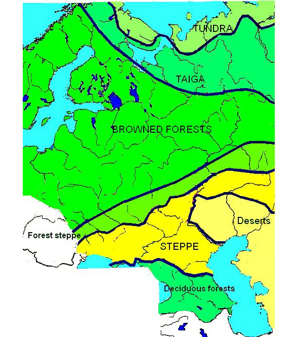
Natural areas in the Mesolithic
S. V. Oshibkina writes that: «Natural conditions, according to most researchers, were especially important in the early period of history, when they determined the economic activity of a person, although they probably had no decisive significance in the historical development of society. There is an opinion that the most significant restructuring of society took place at the boundary between the Paleolithic and Neolithic and was associated with sharp changes in natural conditions at the beginning of the postglacial period.»
Many modern researchers believe that during the Middle Stone Age -Mesolithic in the north-west of Eastern Europe, there was a significant influx of population from the south-west from the Volga-Oka and Baltic-Dnieper regions, where, based on the Late Paleolithic Swider culture, new ones arise, already Mesolithic cultures. At the same time, a number of archaeologists believe that the origins of Swidersk culture, the finale of which falls on the beginning of 8 thousand BC, should be sought in the southeast among the Late Paleolithic cultures of the Kostenkovsk-Borshevsky region on the Don.
It was previously noted that 25—29 thousand years ago, there was a certain connection between the Don Paleolithic cultures and sites on the Pechora River (Kostenki I, 12 and Byzovaya site). Currently, the question of the origins of the wider Late Paleolithic culture remains debatable, but researchers believe that the population that left the monuments of witness culture, at the beginning of 8 thousand BC migrates north and northeast.
Based on the Swider culture in the Volga-Oksk interfluve in the middle of 8 thousand BC the so-called Butovo culture, represented by four groups: Meshchera, Pereyaslavl, Kostroma and Lower Oka.
It should be noted that monuments with Butovo elements were found in the Novgorod region, in the Middle Volga region and in the Sukhona river basin.
«The economic structure of the Late Butut tribes is based on hunting. The population at this time, according to paleographers, lived in dense broad-leaved forests. The main object of hunting was probably forest fauna – elk, bison, red deer, wild boar, etc.»
From the second half of 7 thousand BC and until the second half of 6 thousand BC in the Volga-Oka basin, the Yenev culture tribes spread, coming from the territory of the Upper Dnieper and ousting the Butovites from their original territory to the north and northeast. But already in the second half of 6 thousand BC the descendants of the exiled Butovites in turn oust the Yenev population and return to their original lands. At the same time, a population of Ust-Kama culture appears on Kama, supposedly related to Yenev culture advanced east from the basin of the Upper Dnieper.
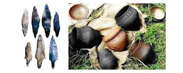
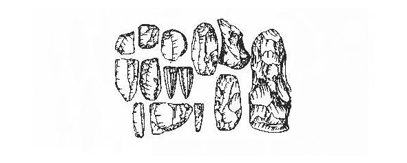
Products of the Swider culture
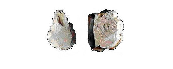
Products of Butovo culture
Products of Yenevskaya culture
Products of Ust-Kama culture
In general, the Mesolithic era differed from the Paleolithic exceptional mobility of the population. So already in 7 thousand BC according to modern anthropologists based on the study of the bone remains of the Oleneostrovsky burial ground, in the region of Lake Onega, a mixture of northern and southern Caucasoids took place.
Significant advancement of the North European population to the south at the turn of the Mesolithic and Neolithic eras is evidenced by the data cited by D. I. Telegin. Comparing the burial rite of the north and south of Eastern Europe, he notes that for the northern latitudes, already from the Paleolithic, the burial of the dead in an elongated position on the back, in contrast to those crouched in the south. So all the skeletons of Sungir (24 thousand BC) lay on their backs in an elongated position. In the Mesolithic Oleneostrovsk burial ground (7 thousand BC) on Lake Onega there are 118 burials elongated on the back, and only 14 on the side. In the burials of the Popovo burial ground (on Lake Lache, the right bank of the Kinem River) of the second half of 7 thousand BC all the dead lay in an extended position on their backs.
D. Ya. Telegin notes what if for the south of Eastern Europe throughout the Mesolithic era the dominant position in the burials was a position crouched on its side, then, during the transition to Neolithic time, a sharp change is noticed in the burial rite, «when the elongated back position becomes prevailing in the position of skeletons throughout the study area. He’s writing: «It seems to us that the reasons for such dramatic changes in the funeral ritual of the population of Eastern Europe on the verge of eras should be sought, firstly, in changing the composition of the population itself, and secondly, in changing his ideology. Moreover, at different times, these factors played, obviously, far from the same role: during the transition from the Mesolithic to the Neolithic, the first factor probably prevailed (i.e., population change.) … So, according to the definition of anthropologists, the Mesolithic population of Ukraine, who left the Voloshsky-Vasilievsky-type burial grounds with burials buried on their sides, belongs to the Mediterranean race, while the Neolithic tribes who replaced it are characterized by all the signs of the Late Cro-Magnon type (the so-called subglacial North European type.). It is to these tribes that the numerous burial grounds of the Dnieper-Donetsk culture belong, where the skeletons lay in an extended position in rows. Consequently, a noticeable sharp change in the rite of burial here is associated with a change in population.»
So, in the Dnieper at the boundary of the Mesolithic and Neolithic (at the end of 7 – beginning of 6 thousand BC), a new population comes from the northern regions. At the same time, even in Pechora appear groups that came from the southwest.
More than a hundred sites of the Mesolithic era are open in the Vologda Oblast. S. V. Oshibkina notes that the sites of the Sukhona River basin (Kolupaevskaya on the Staraya Totma River and Yasnopolyanskaya on the tributary of the Sukhona River, Sombol River) existed surrounded by forests of pine (27%), birch (25%), linden (33%), oak (1%), hazel (2%), and the percentage of linden increases over time. S. V. Oshibkina emphasizes that: «As established by M. I. Neishtadt, the period of domination of broad-leaved species and alder falls on 2500 – 7700 years from our days or 5700 – 500 years BC.»