

 полная версия
History of New Brunswick
Another large lake called Washademoak, lies a little below the Jemseg, and is separated from the Grand Lake by a range of highland. This lake is from twenty-four to thirty miles long, and from two to three miles wide. A stream falls into this lake, called the Washademoak river, which rises near the bend of the Peticodiac. It has a settlement along its banks, called New-Canaan. There is a mixture of intervals and upland along this settlement, well covered with timber of various kinds. The Washademoak lake is well settled, and empties into the St. John, opposite Long Island.
The Parishes on the western side of the river are Gagetown and Hampstead. Gagetown is regularly laid out, and is the county town. It has a handsome Church, with a settled Pastor; a Court-House and Gaol, with several fine private buildings. As was observed before, several fine Islands lie in this county, one of them, named Long Island, is six miles in length and well improved. It has a neat Church, in which divine service is occasionally performed. It has likewise a tavern, with as good accommodations and as well kept as any in the country. The streams in this county on the western side of the river, have nothing peculiar to merit a particular description. Gagetown Creek runs past the Township of that name, and facilitates the navigation of that part of the country, and the Ocnabog is the tunnel through which the waters of a small lake of that name are discharged into the Saint John. I must not forget to notice that in front of Gagetown there is a bend in the river, which some ill natured person has saddled with the forbidding name of "No Man's Friend" although there is nothing unfriendly about the place, and it should rather be called "Pleasant Reach" as the adjoining country is very pleasant.
A new Parish has lately been erected in this County, called Brunswick, which lies back of Waterborough and Wickham, and comprehends the settlement of New-Canaan and the district adjoining.
SECTION IVKing's CountyLies likewise on both sides of the river Saint John, and is bounded on the North by a line running South West and North East, from the South point of Spoon Island in the river Saint John. On the East by Northumberland and Westmorland. On the West by Charlotte, and on the South by the County of Saint John. It contains seven thousand nine hundred and thirty inhabitants.
It comprehends the Long Reach, the Kennebeckasis and Belisle, and is divided into the following Parishes – Westfield, Greenwich, Kingston, Springfield, Norton, Sussex, and Hampton. Kingston has a Township regularly laid out, which bears the name of the Parish. It has a neat Church, with a resident Minister, and a number of neat buildings, which make a fine appearance. The Court-House, however, is a considerable distance from the Town. The settlers in most parts of this Parish have the appearance of comfort and affluence, although the land is inferior in fertility to most of the other Parishes. The Parish of Sussex has a Church with a resident Minister, and an Academy for the instruction of the Indians, but little good has accrued to these wanderers from that Institution. A beautiful strip of land lies in this Parish called the Vale of Sussex, which is highly cultivated and covered with excellent houses and barns. – Agriculture is in general well attended to, and its effects are evident in independent farmers, good stocks of cattle and an air of comfort and cheerfulness, the sure returns of industry and husbandry. The roads and bridges are in good order and well attended to. The great road of communication passes through this Vale to Westmorland.
The river Kennebeckasis intersects this county, and falls into the Saint John, near the Boar's Head. This is a considerable stream, and has several Islands scattered through its course. It is navigable upwards of twenty miles for vessels of any burthen, and sixty miles farther for small vessels and boats. It is well adapted for Ship-building, having abundance of excellent timber in its neighborhood, and several vessels are annually built here for the merchants of Saint John.
The Nerepis another considerable stream, falls into the Saint John at the foot of the Long Reach. This river runs a considerable distance into the country and has a settlement along its banks.
There are two quarries of excellent Plaster of Paris on the river Kennebeckasis. There is likewise a salt spring in this part of the country, from which small quantities of salt have been made by the Indians and Inhabitants settled near the place, which has proved of an excellent quality for the table, and there can be no doubt of its possessing valuable medicinal qualities; but no attention has yet been paid to analyse it. Great quantities of sugar are extracted from the sugar maple in this county, upwards of ten thousand pounds have been made in a year, of that valuable article in one Parish.
Several of the Parishes in this county have Churches, some of which have stated Pastors, and others are supplied occasionally.
SECTION VSaint JohnThis County is bounded northerly by a line running East North East, and West South West, from the southernmost point of the Kennebeckasis Island. Westwardly by a North line from Point Lepreau. Eastwardly by Hopewell Township, and on the Southward by the Bay of Fundy. It has four Parishes. The City of Saint John, Portland, Lancaster, and Saint Martins. It contains a population of twelve thousand nine hundred and seven inhabitants. This county has several fine harbors; the principal of which is the harbor of Saint John, at the mouth of the Saint John river and which was noticed in the description of the city. This harbor has a valuable fishery for Salmon, Herring, and Shad. Formerly from two to three thousand barrels of Shad, twenty thousand barrels of herrings, and a vast quantity of Salmon were taken here annually; but the fishery has fallen off very much of late years. A Cod fishery might also be prosecuted to advantage not far from Partridge Island, but this is totally neglected. The other harbors are Quaco, Musquash, and Dippoo harbor, down the Bay, which have nothing particular. They have water sufficient for vessels of four hundred tons burthen.
The lands, in the county and along the sea-board are not so good for farming as those in the interior. They are generally very rocky and uneven. In many places they are mere barrens being covered with a stunted growth of shrubs. There are however good spots intermixed, and many places that formerly appeared doomed to sterility have been brought under a good state of cultivation. Great improvements have lately been made in farming in this county. Many new settlements have been formed and are rapidly improving. Several merchants and persons of property in the city of Saint John have lately improved farms in its vicinity; particularly on the Marsh and at Loch Lomond. It will certainly be a great advantage to the Province, if men who possess capital, employ a part of it in improving the country. By this means many poor districts of sterile land may be reclaimed, and improved by the wealth of the city; to the great advantage of individuals, and benefit of the settlement where such improvements are made: as the citizen will lay out from year to year, no more than he can spare from his other pursuits, and this when the land is once brought to a good state of cultivation will richly repay him: while the indigent settler will have labour brought home to his own door to enable him to subsist while he improves a small spot for himself, which without such a resource he could not attempt.
A great strip of Marsh lies contiguous to the city, some of which is dyked and yields excellent grass. The whole district is rapidly improving to the great advantage of the city. Several wealthy citizens have lately made great improvements here, and some fine seats are nearly completed.
The Parish of Portland contains old Fort Howe. This Fort is situated on a rugged hill at the mouth of the river Saint John, and completely commands the harbour. Portland is well built up, but the road near the Fort is very narrow, and in a wretched state, considering that it is the only thoroughfare from the city, to the Indian House, so called; which is situated in front of the bay, just above the falls, and where vessels and boats come too, going and coming to wait for the tide, and where passengers from all parts of the river land, and frequently walk over the tongue of land to Saint John, which is a little more than a mile. Passengers likewise going up the river in the Steam-Boat or Sloops, usually ride or walk from Saint John to the Indian House, and baggage and goods of all descriptions, are transported above the falls by this route, which keeps the road continually thronged, and points out the necessity of having a good and safe communication in such a public place. There is no public place of worship in Portland of any denomination: the inhabitants resort to the different places of worship in the city.
The settlements of Quaco, Manawagonish, Musquash, &c. are in a flourishing state. Considerable progress has been made in Agriculture, and there is reason to believe the country round the Bay shore is rich in minerals. Manganese has been found at Quaco, and the adjoining district, which has been sent to the United States, and is said to be of a good quality.
SECTION VIHaving in the preceding sections briefly described the five Counties lying along the river St. John; I shall now proceed with the three remaining, commencing with
CharlotteThis County is bounded by the Bay of Fundy on the south, by the St. Croix river, and the Bay of Passamaquoddy on the west and south west, on the east by a north line from Point Lepreau, and on the north by a west line commencing in the said north line thirty-three miles from Point Lepreau, and contains nine thousand two hundred and sixty-seven inhabitants.
It is divided from the United States by the river St. Croix, commonly called the Schoodick, which is the line in this quarter that divides the territories of His Britannic Majesty from the District (State) of Maine. It comprehends several large Islands in the Bay of Passamaquoddy, and is divided into the following Parishes: – St. Andrews, St. Stephens, St. Davids, St. Patricks, St. Georges, Pennfield, Campobello, West Isles, and Grand Manan.
The Parish of St. Andrews, besides the town of that name already described, possesses many advantages for trade, being situated very conveniently for navigation. It has several Saw-Mills, and a great quantity of boards, planks, &c. are shipped from that port.
St. Stephens likewise furnishes vast quantities of sawed lumber. The mills in this parish on the river Schoodick are very numerous. More than four million feet of boards and planks are cut in this Parish annually. Ship-building is likewise carried on to considerable extent. Large quantities of shingles and small lumber of different descriptions are also furnished here for exportation. There is a Methodist Chapel with a stated Minister in this parish. The country is considerably improved, having several good farms. It has likewise a good herring fishery at the falls of the Schoodick.
St. Davids has likewise some good saw-mills. It also furnishes masts, and squared timber for shipping. The land in this Parish is of an excellent quality, and produces wheat, oats, Indian corn, potatoes, &c. in great abundance.
The Parishes of St. Patricks, St. George, and Pennfield, have each a number of saw-mills, and furnish large quantities of sawed lumber of the best quality – the country being well stocked with excellent pine. Considerable quantities of scale fish are also caught and cured here. Great improvements are likewise making in Agriculture in these Parishes, particularly in Pennfield, which produces wheat in great perfection. The settlers in this Parish are good farmers, and are making great improvements.
The Parishes of Campobello and Deer Island comprehend the Islands so called. Campobello includes the Islands on the south east side of Passamaquoddy river. It contains several thousand acres of land fit for cultivation. Many of the inhabitants are employed in the fishery along the shores. Great quantities of cod and other fish are taken about the Island, and sold uncured to the Americans. Formerly most of the gypsum exported from this Province was landed on this Island where it was shipped on board American vessels for Philadelphia and New-York.
Grand-Manan is likewise a considerable place for fishing, Ship-building, &c. and is of considerable importance in a nautical point of view, as it lies near the entrance of the Bay of Fundy. It is fourteen miles long and seven miles broad. The Northernmost point is in latitude 44° 54′ longitude 66° 45′ west.
The rivers Maggagaudavick and Digdaguash, lie in this county, and are of the utmost advantage in transporting the lumber from the interior. On each of these streams mills are erected. The Maggagaudavick runs a great distance into the country, and communicates with a chain of lakes, down which lumber is floated from a great distance. There are several falls in the Maggagaudavick – those near the mouth are nearly forty feet.
Several Islands lying in Passamaquoddy Bay are within the limits of this county. Some of them are of considerable importance, on account of the fishery, and as affording harbors for shipping.
SECTION VIIWestmorlandIs bounded eastwardly by the line of Nova-Scotia, and the Gulph of St. Lawrence; northerly, by a west line running into the country from the northernmost point of Shediac Island; westwardly, by a line beginning at a point in the north boundary of St. John County; north, from Quaco head, and running north till it meets said west line; southerly, by St. John County and Chignecto. It contains nine thousand three hundred and three inhabitants.
This County is situated at the head of the Bay of Fundy, and joins Nova-Scotia. The line between the Provinces is the narrowest part of the isthmus between the Bay of Fundy and Bay Verte. A small stream over which there is a bridge – forming the separating line. It contains the following Parishes: – Westmorland, Sackville, Hillsborough, Hopewell, Moncton, Dorchester, Salisbury, and Botsford.
A considerable part of this county was formerly settled by the Acadians or French neutrals, whose descendants are still numerous in this and the adjoining County of Northumberland, being spread along the seaboard, to the Bay of Chaleur. They have settlements at Memramcook, Peticodiac, Bay Verte, Cocagne, Bucktouche, Richibucto, &c. – where there are several large Chapels, which are usually supplied with Romish Missionaries, who are supported by tythes from the French Catholics. But the most thriving class of settlers are the English, chiefly from Yorkshire, or their descendants. They are in general good farmers and attend chiefly to husbandry. Indian corn is but little cultivated in this county, the climate being too cool and temperate for that plant to thrive well; but wheat, oats, potatoes, &c. flourish here in great perfection. This is the finest part of the Province for stock; from the extensive tracts of salt marsh which lie in this county, many thousand acres of which are dyked and produce abundant crops. Butter and cheese are made and exported from this county in large quantities. The cattle are superior to any in the country from the great attention that has been paid by the inhabitants to crossing and improving the breed. During the American war nine hundred head of cattle, and eight hundred firkins of butter, were sent from this county to Halifax, and other places in one year, and although the demand has fallen off since the peace, there are still large droves taken from Cumberland to Halifax, and St. John – and likewise large quantities of butter and cheese.
The tides at the head of the Bay rise to a great height. They come in with successive swells of the water called the Boar, which at spring tides roll in with amazing velocity in waves about three feet perpendicular. The noise of the Boar is heard a great distance, and animals immediately take to the highland, and manifest visible signs of terror if near it. The spring tides at Cape Chignecto, Cape Enrage, and Cumberland bason, are from forty-five to fifty-five feet. Common tides at Cape Chignecto, thirty-six feet; at Cape Enrage, forty feet; at Fort Cumberland, forty-five; and at Bay Verte, from eight to ten feet perpendicular.
The shores from Cape Chignecto and Martin's Head to the Joggins, or land of Grindstones, are high, bold and rocky. On other parts of the coast they are not so elevated, but abound in most places with valuable stones of different kinds, fit for building and other purposes. Great quantities of Grindstones are made in this county, and furnish a valuable article for exportation. Nearly twenty thousand were formerly exported from this place annually, to the United States, and other places, but this branch of trade has fallen off considerably of late years.
Fort Cumberland formerly called Beausejour, is situated on the Missaguash river in this county. It was the first post fortified by the French in this Province, and was for a long while a great annoyance to the English settlers, till it was taken by Colonel Monckton, in 1755, who placed a British Garrison in it. The works are at present much decayed, a few soldiers are however still stationed in it.
The several parishes in this county are in a flourishing state. Some of them have neat places of worship with stated Ministers, and others are visited occasionally. Westmorland in general, is well settled, with a substantial yeomanry, and although it does not make such a figure in a bustling trade as some of the other counties, it is silently enriching itself with the slow but sure returns of Agriculture, and fast rising into importance.
The rivers in this county are the Peticodiac, Memramcook, and Missaguash with several other streams which run a considerable distance into the country. Some of them are well settled along their banks. The main road from Saint John to Cumberland follows the Peticodiac nearly throughout its whole course.
There are no sea-ports in this county of consequence. Dorchester has but little trade, and Chediac, is near the lines in Northumberland, although the river runs into this county and facilitates the export of its produce.
SECTION VIIINorthumberlandJoins Westmorland on the southward, and is bounded eastwardly by the Gulph of Saint Lawrence, and Bay of Chaleur. On the northwestward by the Bay of Chaleur to the river Ristigouche, and westwardly by a continuation of the western boundary line of Westmorland. The population of this county amounts to fifteen thousand eight hundred and twenty-nine.
This extensive county lies along the Gulph of Saint Lawrence having a great extent of sea-coast. It includes several large bays and rivers, and comprises more than one third of the Province. It contains the following Parishes: – Newcastle, Chatham, Ludlow, Northesk, Alnwick, Carleton, Beresford, Glenelg, Saumarez, Wellington, and Nelson. It is a great lumbering county, and furnishes more squared timber annually than the whole Province besides: The pine is of the best quality, and found in immense quantities along the numerous streams and rivers with which this part of the country abounds. The lumber shipped from this county generally commands a better price in the British market than from any other part of the Province. The principal port for shipping is Miramichi, which is crowded with vessels during the summer and autumn. The river has two main branches called the northwest and southwest. Vessels load in different parts of the river, and rafts are brought to the shipping with the greatest ease. Shipping go up the river as far as Fraser's Island for cargoes and farther on the northwest, where there are several trading establishments. Newcastle is a considerable place for loading, and although it may be considered the county town, has nothing particular. About two miles below this place there is a trading establishment belonging to Mr. Abrahams, and two miles farther down is the establishment of Rankin, & Co. Indeed wherever there is a convenient cove, vessels lay and load. Chatham four miles below Newcastle on the opposite side of the river, is also a considerable shipping place. It has a Church with several fine stores and buildings. There are but few places along the entrance of this river but what are convenient for shipping. Upwards of three hundred sail load annually at Miramichi. The timber is paid for part in specie, and part in British and West-India goods and provisions.
A stranger would naturally suppose, that such a trade must produce great riches to the country; and that great and rapid improvements would be made. That large towns would be built – that the fair produce of such a trade would be seen in commodious and elegant houses, extensive stores and mercantile conveniences, in public buildings for ornament and utility, good roads and improved seats in the vicinity of the sea-ports, with Churches, Kirks, Chapels, &c.: All these with many other expectations would be but a matter of course. But here he would not only be disappointed, but astonished at the rugged and uncouth appearance of most part of this extensive county. There is not even a place that can claim the name of a town. The wealth that has come into it, has passed as through a thoroughfare to the United States, to pay for labour or cattle. The persons principally engaged in shipping the timber have been strangers who have taken no interest in the welfare of the country; but have merely occupied a spot to make what they could in the shortest possible time. Some of these have done well, and others have had to quit the trade: but whether they won or lost the capital of the country has been wasted, and no improvement of any consequence made to compensate for it, or to secure a source of trade to the inhabitants, when the lumber shall fail. Instead of seeing towns built, farms improved, and the country cleared and stocked with the reasonable returns of so great a trade; the forests are stripped and nothing left in prospect, but the gloomy apprehension when the timber is gone, of sinking into insignificance and poverty. Formerly the woods swarmed with American adventurers who cut as they pleased. These men seeing the advantages that were given them, and wishing to make the most of their time, cut few but prime trees, and manufactured only the best part of what they felled, leaving the tops to rot; by this mode more than a third of the timber was lost. This with their practice of leaving what was not of the best quality after the trees were felled, has destroyed hundreds of thousands of tons of good timber: And when this was stopped by permitting none but British subjects and freeholders to obtain licenses, the business was not much mended as any person wishing to enter into the trade could, by purchasing a small sterile spot for a small trifle (provided he was a British subject) get in the way of monopolizing the woods. These are some of the causes that have and still do operate against the prosperity of the country. Men who take no interest in the welfare of the province, continue to sap and prey on its resources.
The other sea-ports in this county are Saint Peters, Richibucto, and Ristigouche, at which places there is a considerable trade carried on in squared timber, &c. but they have nothing of consequence to merit a particular description. Besides the Miramichi already described, this county is watered by several considerable rivers, the principal of which is the Ristigouche, which falls into the Bay of Chaleur, and communicates by a short portage with Grand River which falls into the Saint John fifteen miles above the great falls. The smaller rivers are numerous, some of them have settlements along their banks and others are but little known. The inhabitants are a mixture of Europeans and Americans. A number of the descendants of the French neutrals are settled in this county, particularly on the river Cocagne where there are several villages with Catholic Chapels; they are also settled at Buctouche, Richibucto and along the sea-board as far as the Bay of Chaleur. They are generally agriculturalists and quiet orderly settlers.
Having thus gone briefly through the different counties, I shall conclude this chapter with a statement of the distances of the principal points on the Great Road of communication from St. John to Quebec:
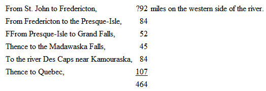
making in the whole a distance of four hundred and sixty-four miles from the sea-board to Quebec, according to the present routes; nearly two thirds of which is along the great river St. John.