

Полная версия
The Hebrides
The Hebrides do not occupy a grand plinth in scientific history as do the Galapagos, but, like all other archipelagos, they have their own endowment of nature and well-kept secrets to be discovered and enjoyed. The Galapagos are celebrated for their biology, but their geology (Simkin, 1984) is far less illustrious than that of the Hebrides. In studies of evolution and biogeography, the oceanic islands are unmatched by islands, like the Hebrides, that are strung along the continental edges. However, in studies of geology, ecology and animal behaviour, the continental edge is of the greatest interest. For example, the natural environment of the British Isles can be described as ‘maritime’, when compared with continental Europe. In greater detail, the western seaboard, including the Hebrides, when compared with the bulk of mainland Britain, is termed ‘oceanic’, because the communities of plants and animals there thrive in moist, mild conditions, or are greatly affected by the sea. It is this contrast of living conditions and life forms which has broadly attracted biologists to the Hebrides, while the geologists have been attracted to the Pre-cambrian and Tertiary rocks which are poorly represented in Britain south of the Great Glen. There are ample opportunities to observe how the structure of habitats changes from south-east to north-west, and also how each island has acquired its own rock base and complement of living things. Indeed, each island has its own unique and rich potential for the study of natural processes.
Island Races
Every island has a ‘gene pool’ and, between the islands and the mainland ‘reservoir’, there is a constant but usually small ‘gene flow’. Each island is a unique assembly of species, which have been brought together by natural or man-assisted colonisation over long periods of time. Genetically, it is important to distinguish between ‘relict’ species which were present on the land before it became an island, and the colonisers which arrived after the land became an island. Small founder groups of either category possess fewer alleles of each gene than the large mainland populations from which they derive. When the founder group has grown and becomes established, the island species can have different frequencies of the different morphs than in the parent population. This is the theory anyway—in reality the situation is much more complex.
In the Hebrides, the islands became colonised from the south as the British Isles emerged from the retreating ice sheet. As time advanced more and more plants and animals arrived. Changes in sea level destroyed ‘land bridges’, thus isolating fragments of erstwhile mainland populations. The flora and fauna resulting from natural colonisation and physical isolation have been further complicated by man-assisted colonisation. Again in theory, many original colonisers of the north of Scotland may have been eliminated from the mainland by species which arrived later but did not reach the islands. The Hebrides, therefore, may possess relict life forms, such as the fossorial bee (Colletes floralis), the arctic charr (Salvelinus alpinus), and the plant Koenigia islandica. The Soay sheep (Ovis aries) of St Kilda is an outstanding example of a domesticated animal introduced by man to Britain in neolithic times, which became extinct as a breed (superseded by improved breeds of sheep) in all areas except the remotest and most inaccessible of islands, Soay at St Kilda.
The distribution of species in the Hebrides, therefore, begs many questions of when and how they came to be there. Analysis of pollen from peat and the beds of lochs have shown much of the time-scale and species of colonisation of the islands by vegetation; the affinities of most plant species to ‘oceanic’ and ‘continental’ biomes have been described; problems of taxonomy have arisen and identification of rare or key species has been questioned when voucher specimens and satisfactory records were lacking. However, the biogeography, taxonomy, and genetics of the Hebridean flora and fauna is still a wide-open field for research. This work is closely linked to the need for more information on the invertebrate fauna—and, with new techniques such as ‘genetical fingerprinting, in the revision of existing information on the entire biota.
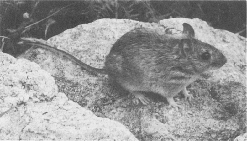
St Kilda field-mouse (Photo D. MacCaskill)
The flora and fauna of the Hebrides are rich in distinct island taxa: the St Kilda sub-species hirtensis and the Rum sub-species hamiltoni of the field mouse (Apodemus sylvaticus), (Delany, 1970); dark Hebridean forms of the dark green and the small pearl-bordered fritillaries (Argynnis aglaia and A.selene), the common blue (Polyommatus icarus), the grey mountain carpet (Entephria caesiata), the twin-spot carpet (Perizoma didymata), the mottled beauty (Alcis repandata), and the lesser yellow underwing (Noctua comes). Distinct forms of the bumble bee Bombus jonellus and the dragonfly Sympetrum nigrecens occur in the Hebrides. Amongst birds, the St Kilda wren (Troglodytes t. hirtensis) is distinct from that of the Hebrides (T.t.hebridensis), and in fact more closely resembles the Fair Isle wren (T.t.fridariensis), which in turn is distinct from the Shetland wren (T.t.zetlandicus). Starlings (Sturnus vulgaris) from Shetland and the Outer Hebrides are thought to be distinct from the race occupying the rest of Britain.
Professor R.J. Berry (1979, 1983) has examined the genetical and evolutionary significance of the Hebrides, where in his own words ‘genes and geography meet’. He concludes:
The physical tides that have caressed and pounded the Western Isles have biological parallels: waves of animals and plants have beaten on the islands and formed their biological environment in the same way that the waves of rock, ice and water have determined their geographical limits. And just as the physical waves have laws which must be obeyed, so the interactions of drift, migration, and selection have forged the genetical constitution of the island races; and as the incoming tide cleans the sands and rocks over which it passes, but leaves unexplained features in secluded eddies, so the biological tides have left us with many genetical puzzles. The scientist believes as an article of faith that these eddies can be explained as knowledge accumulates, though some will remain as statistical anomalies of history.
Grand Relationships
We have used the example of genetical evolution and change to set the islands in the light of scientific discovery. We see the Hebrides not simply as the beautiful physical shapes they are, but as complete little worlds in themselves—each a unique repository of life. But there are also the rocks and the puzzles they hold. We try to interpret the genesis of the Hebrides from the Geological Record and find, in the great span of geological time, that part of the earth’s surface which was destined to become the British Isles, moved northward across the surface of the globe from tropical to temperate latitudes. Having done so, and assumed its present geographical stance, the crustal plates parted and the British Isles were formed. This is a spellbinding story captured forever within the rocks of Ireland and Western Scotland, including the Hebrides. The disentanglement of the rocks on the north-west seaboard of Scotland, which plumb the depths of 3000 million years, is a wonderful achievement, and now part of classical geology of world-wide significance. The dynamic, three-dimensional perception of geological processes over such long periods of time, punctuated as they were by upheavals of the earth’s crust such as the Grenville and Caledonian orogenies and the Moine Thrust, are so complex as almost to defeat lay presentation.
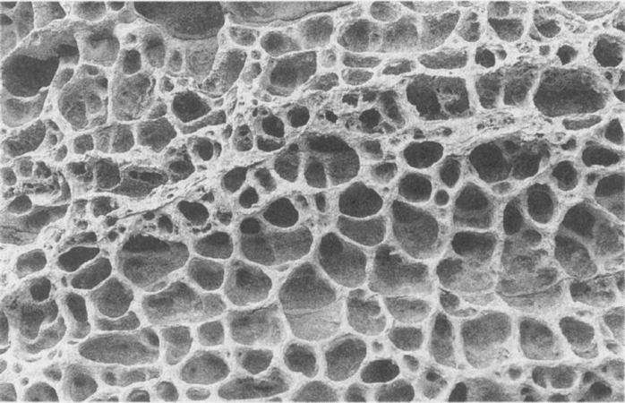
Looking like a living tissue, the Jurassic sandstone at Elgol, Skye has been eroded by the sea into this delicate, pale yellow, lacunary web (Photo J. M. Boyd)
The coral islands of tropical seas display a biological process in which living corals extract lime from the sea water and build enormous reefs which, following changes in sea level, become raised islands or coastal platforms. In the Hebrides, there is at work a similar grand relationship between sea, land, and air, in which marine invertebrates and algae provide a vital link in the accretion of shell sand. Since the end of the last ice age, about 10,000 years ago, vast quantities of lime have been extracted from the sea-water by countless generations of shell-forming animals, whose remains have been ground in the surf and cast up by sea and wind upon the rocky shores. Spacious coastal platforms of dunes and machair (Hebridean maritime grassland) have been formed in the southern Outer Hebrides, Tiree and Coll, enriching both the natural and human ecology of these islands (See here). The whole process is supported by untold numbers of animals and plants of many different kinds. A thimbleful of shell sand, spread and magnified, will reveal the fragmented shells of a host of humble creatures, each of which makes its tiny but vital contribution to the grand scheme.
Islands for Science
The Hebrides, therefore, have a potential for research in fundamental, natural processes, and none have been used more than Rum and St Kilda for this purpose. In the 1950s, both of these islands were recognised as outstanding for their unique flora and fauna. They have concise temperate/maritime ecosystems and classical geology, and are laboratories for long-term ecological research. Accordingly, they were made National Nature Reserves in 1957 and have been centres for research ever since.
Studies of the fundamental biology of large herbivores—the red deer on Rum and the Soay sheep on St Kilda—have been central research endeavours, which have provided an understanding not only of the animals themselves, but of the ecology of their whole island. The research on the red deer on Rum has been done in controlled conditions, which would be hard to obtain among wild deer on mainland deer forests. This has revealed the precise structure and dynamics of the deer population, and the behaviour of stags and hinds, through entire life-spans. At St Kilda, the mechanism of natural control of numbers of a free-ranging (unmanaged) population of Soay sheep has been studied over thirty years. These sheep have survived in their island home for probably over 1,000 years, and the mechanism of control of numbers seems to protect them and their habitat from degradation through overpopulation and inbreeding.
Twenty-two species of seabird breed in the Hebrides. St Kilda alone has fifteen species and possibly holds over a million seabirds in summer. The oceanic seabirds—petrels, auks, gannets and kittiwakes—have the mystical beauty of all truly wild creatures. They live most of their lives far upon the face of the wide ocean, and in summer they gather in their thousands for a great carnival of nesting. The beauty and excitement of the birds wheeling and darting in the splendour of sunlit cliff and chasm brings awe and rapture to the dullest of hearts. For those who brave the benighted tops of Rum or the cliff terraces of the outliers there is a contrast equally as moving—the weird, dark world of the night-flying petrels.
The study of the seabirds poses physical as well as intellectual problems. Simple routines of counting the birds and interpreting the census data are difficult to achieve with any degree of consistency between counts. Nonetheless, in the past thirty years, marine ornithologists throughout the world have greatly improved census methods of many species which present different technical problems. For example, gannets and fulmars nesting in the open require different techniques from burrowing puffins, and both are different from night-flying petrels. To detect changes in the size of the populations, a sustained census effort is required over decades, and this needs forward planning and the handing on of the techniques to successive workers.
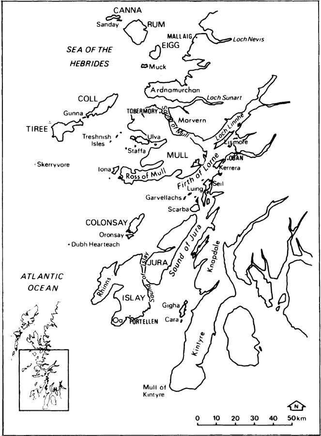
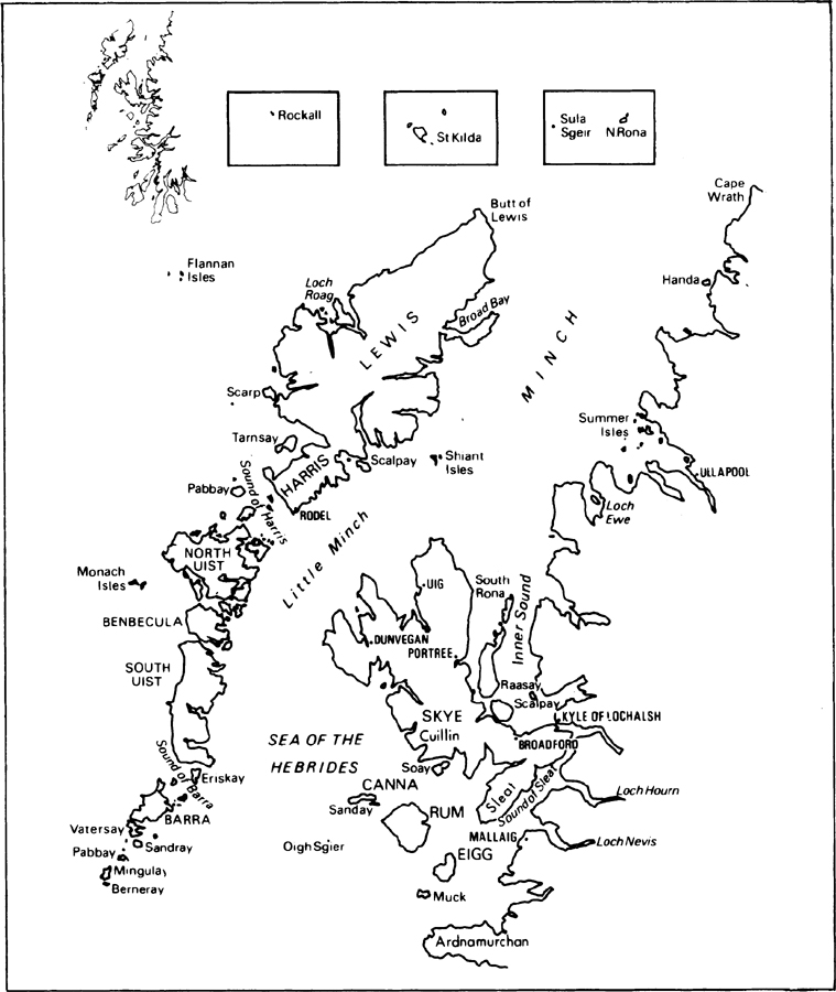
Figs. 2 a & b Location maps of the Outer and Inner Hebrides
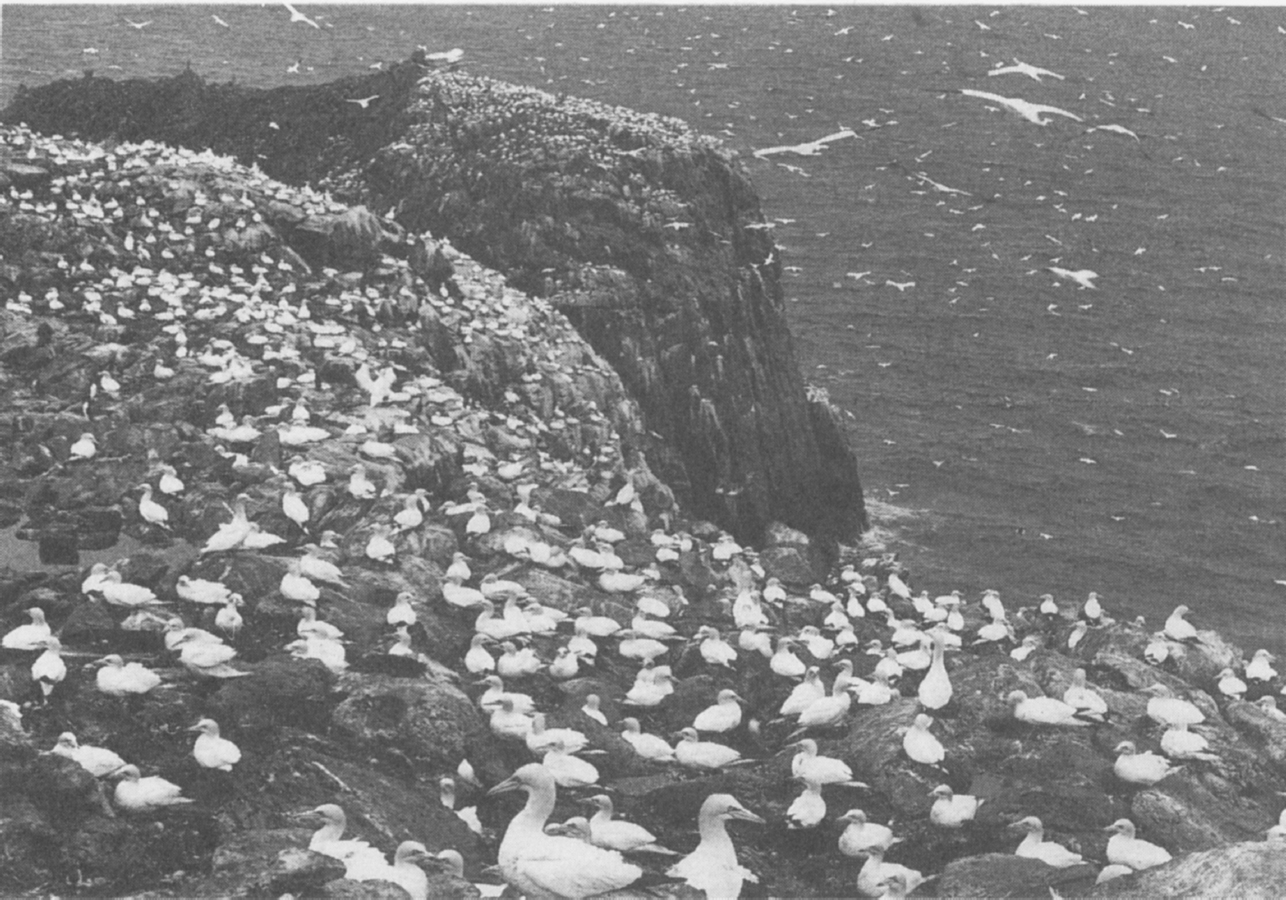
The south-east face of Sula Sgeir showing the northern limits of the gannetry in 1962 (Photo J. M. Boyd)
The seabirds of the Hebrides are a major part of Britain’s heritage of wildlife, requiring study for its own sake. However, the status of the seabird populations can also be an indicator of the health of their environment. Through the food chain which starts with the microscopic life in the sea and passes through invertebrates and fish, the seabirds can become the repository of pollutants such as polychlorinated biphenols (PCB’s) and heavy metals. Such pollutants are likely to affect the breeding performance of the seabirds and the golden eagles and sea eagles which feed upon them in the Hebrides. In the case of a Chernobyl-like nuclear fall-out in the north-east Atlantic, St Kilda might prove an invaluable nuclear sensor. The great puffineries are rich in marine organic debris gathered from a wide area of ocean. They are grazed heavily by sheep which could become contaminated. The concentration of radio-active material in the individual seabird might be very small, but that in the bone marrow of the lambs may be much greater. Is it too imaginative to see the seabird-sheep islands as future sensors of the marine environment?
CHAPTER 1
Geology
What happens to us
Is irrelevant to the world’s geology
But what happens to the world’s geology
Is not irrelevant to us.
We must reconcile ourselves to the stones,
Not the stones to us.
Hugh MacDiarmid
Natural history starts with the elements of fire, earth, air and water all of which long pre-date life on the face of the Earth. No clear understanding of the origins and nature of life can be obtained without knowledge of the rocks, weather and conditions of the seas and freshwaters. It is on the interface between these elements that all life has sprung and been maintained throughout aeons of time, and nowhere is this truth more explicit than in an archipelago. There, among the islands, the grand relationship between land, sea and sky is obvious and makes a deep appeal to the human mind. Islands are a source of inspiration and happiness; their beauty is enshrined in a multitude of native island cultures all over the world and appreciated by historian, artist and scientist alike. The Hebrides are no exception. In them it is possible to trace the connections between these base elements and the lives of the wild creatures and human beings that spring from them, and to see the islands as one large system with its own in-built stops and balances in terrain, weather and ocean. Let us start with the rocks.
The span of geological time represented in the rocks of the Hebrides is almost as great as anywhere in the world. Though we know that planet Earth is some 4,600 million years of age, in human terms, the Lewisian gneiss formed some 3,000 million years ago is as old as time itself, while on the beds of the sea and the deep lochs the rocks of the future are being formed from the erosion products of by-gone glaciers, rivers and the sea. The cycle of regeneration and decay of hard rock seems timeless when compared with the timespan of human life.
In this vast interval of time, that part of the crust upon which the Hebrides now stand underwent a gradual transposition from tropical to temperate latitudes. Some ages of peace and tranquility are marked by the depositions of the sedimentary rocks: the Torridonian sandstone eroded from a range of mountains and deposited in predominantly desert conditions, 1,000 to 800 million years ago; the sandstones, shales and limestones of Cambro-Ordovician/Dalradian age, 600 to 450 million years ago; and the limestones and mudstones of the Jurassic, deposited in shallow lacustrine or estuarine conditions c. 150 million years ago (called not after the island of Jura, but the Jura Mountains in France).
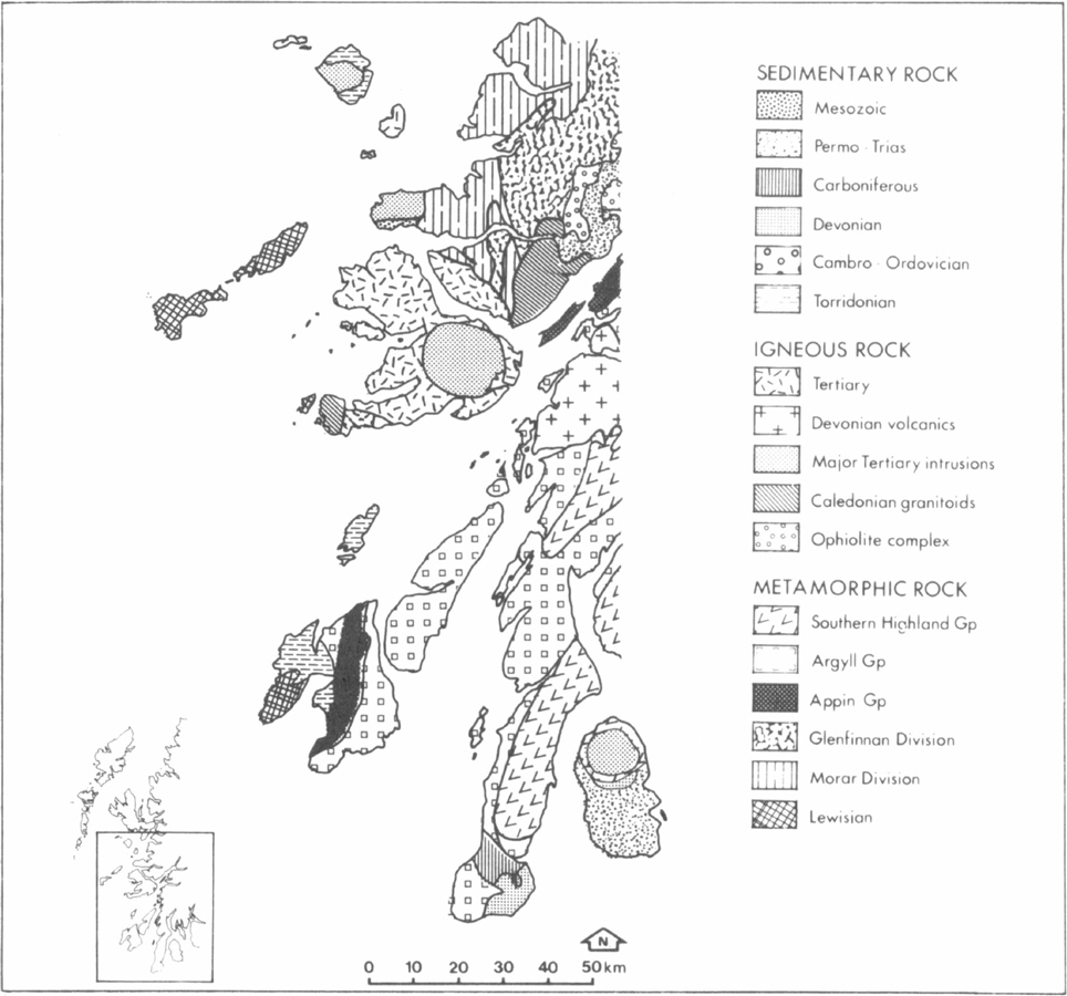
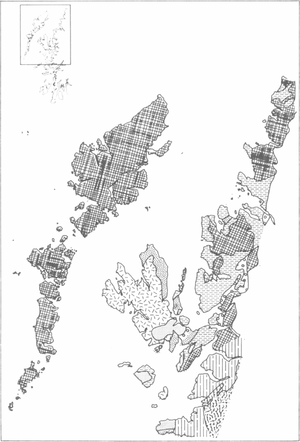
Fig. 3 a & b Geological maps of the Outer and Inner Hebrides (Smith and Fettes, 1979, Craig (ed) 1983)
Between these periods of quiescence there were periods of profound crustal movement as blocks of continental crust fractured, jostled and were transported on plates of underlying crust, though the first of these hardly touches the Hebrides. During the Grenville mountain building about 1,000 million years ago, rocks which were probably the equivalent of the Torridonian strata far to the east of the present outcrops were compressed, deeply buried and heated in the crust, baked and altered to form the schists and metasandstones of the Moine Supergroup. These metamorphic rocks together with unaltered Torridian in turn formed a land surface on which were deposited limestones, shales and sandstones of Cambrian and early Ordovician age.
The second great upheaval was the Caledonian mountain building, 650 to 400 million years ago, when the rocks of the mainland were again folded and altered to form the rocks of mountains now occupying Scandinavia, Scotland and eastern USA. Moine rocks were heated and altered again, while Cambrian strata became the schists of the Dalradian Supergroup. Into the folded and refolded rocks, huge masses of molten crust were emplaced as granite, now widespread in the Highlands and represented in the Hebrides in the Ross of Mull. Along the western seaboard, however, rocks of the metamorphic mountains were thrust upwards and outwards in a dislocation of up to 80km. This is known as the Moine Thrust which runs on the land surface from Loch Eribol to the Point of Sleat in Skye. To the west of the Thrust, the Lewisian, Torridonian and Cambro-Ordovician rocks are in unmoved (and unaltered) sequence; to the east of the Thrust, within the Caledonian mountain belt, lie the Moines of Sleat and western Mull and the Dalradian of eastern Mull, Jura and Islay.
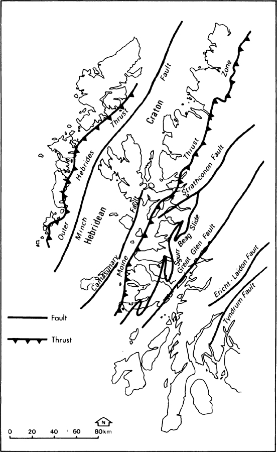
Fig. 4 The main geological faults of the Hebrides and West Highlands (Craig (ed) 1983)
The mountains formed from this orogeny were subsequently eroded to form the Old Red Sandstone (ORS) c. 350 million years ago, a vast continental fluviatile and lacustrine deposit. Orkney is composed almost entirely of ORS but only small outcrops occur in the Hebrides—sediments in Kerrera and Seil, and lavas at Loch Don in Mull.
The third upheaval was the rift of the European and Greenland continental plates which created the British Isles, the continental shelf and the Hebrides, but not as we know them today. This rifting, which began 70 million years ago and still continues today, was accompanied by much volcanic activity, the thrusting up of masses of gabbro and granite, the outblasting of vast quantities of dust, ash and cinder and the outpouring of basalt lavas. These are the Tertiary volcanic complexes of Arran, Mull, Ardnamurchan, Rum Cuillin, Skye Cuillin and St Kilda, with associated plateau lavas in North Skye, Canna, Eigg, Muck, West Mull and Morven. They are related to other such centres in Ireland (Giant’s Causeway), Faeroe Islands and Iceland, where the volcanic activity still continues. The islands as we know them today have been evolved through a northward drift of the crustal plate(s) of the planet from which the British Isles were formed, from a latitude of 30°S to the present latitude of 55°N. Throughout the drift, the palaeogeography was also continuously transformed by mountain building of the type described above, erosion, sedimentation, and volcanic activity. The genesis of the British Isles throughout geological time has been described simply by J.P.B. Lovell (1977).
Geological Framework
The solid geology is shown in Fig. 3 and Table 1.1. The Hebrides lie at the south-eastern margin of a crustal plate which included much of the material which forms Greenland and eastern Canada (Fig. 5). This plate broke and the parts drifted away from each other, ‘floating’ for tens of millions of years on the plastic sub-crust. The great trough between the parts now holds the Atlantic Ocean. This common basement between the Old and New Worlds contains some of the oldest rocks known to science, c. 3,000 million years old, from which younger rocks such as the Torridonian sandstone have been derived, and upon which the sandstones and other younger rocks are placed. In the Outer Hebrides, Tiree, Coll, Iona and Sleat in Skye the gneiss forms the present-day land surface—all the younger rocks have been removed by epochs of erosion. Elsewhere, the basement is covered by an array of younger rocks, or has been penetrated or pushed aside by great intrusions of magma and covered by extrusions of lava.
EraPeriodAge (m.y.)RocksIslandsPre-Cambian+3000–600Lewisian+2800–1200acid & basic gneisses, granites, limestonesN. Rona, Lewis, Harris, Uists, Barra, Coli, Tiree, Skye, Raasay, S. Rona, lona, IslayTorridonian1000–800sandstonesHanda, Summer Isles, Raasay, Scalpay, Skye, Soay, Rum, lona, Colonsay, lslayRocks east of the Moine Thrust affected by the Grenville Orogeny, c. 1000m.y.Moine1000–700schists,Skye, MullSupergroupgranulitesPalaeozoic600–230Cambro-Ordovician600–500piperock, serp. Skye grit, Durness limestoneRocks east of the Moine Thrust affected by the Caledonian Orogeny, 500–400m.y.Dalradian Supergroup+600–500quartzites schistsLismore, Kerrera, Seil, Garvellachslimestones, slatesLuing Scarba, Jura, Islay, GighaSilurian440–400nonenoneDevonian400–350conglomerateKerrera, SeilCarboniferous350–270lava, sedimentsJuraPermian270–225sandstones, conglomerateLewis, Raasay, MullMesozoic230–65Triassic225–180sandstones, conglomerateLewis, Raasay, Skye, Rum, MullJurassic180–135sandstones, limestonesShiants, Skye, Raasay, EiggCretaceous135–70sandstoneSkye, Mull, Eigg, Raasay, Scalpay, SoayCainozoic70–0Tertiary70–1Eocene70–40basalts, granites, syenites, gabbros, dolerites, rhyolitesShiants, Skye, Raasay, Rum, Eigg, Canna, Muck, Mull, Treshnish Is., Staffa, St Kilda, OighsgeirOligocene40–45erosion pdtswidespreadMiocene25–11erosion pdtswidespreadPliocene11–1erosion pdtswidespreadPliocene11–1erosion pdtswidespreadQuaternary1–PresentPliestocene0.6–0.013erosion pdtswidespreadHolocene0.013–0erosion pdtswidespreadshell sandwidespreadTable 1.1 The distribution and age in millions of years (m.y.) of the rocks of the Hebrides.
The major faults in northern Britain run from south-west to north-east (Fig. 4). The Southern Uplands Fault and the Highland Boundary Fault do not affect the Hebridean shelf; the Great Glen Fault (GGF), the Moine Thrust (MT), the Camasunary–Skerryvore Fault (C–SF) and the Outer Hebrides Thrust (OHT) all have an important bearing on the Hebrides. The GGF runs from Shetland to north Ireland, passes between Lismore and Kingairloch, through south-east Mull and just to the north of Colonsay; to the east there are the Caledonian granites with the Dalradian schists, slates and quartzites; to the west there is the Moine Supergroup of schists, bounded in the west by the Moine Thrust and interrupted in the south by the Tertiary complexes of Mull and Ardnamurchan. The only terrestrial sections of the GGF in the Hebrides are from Duart Bay to Loch Buie in Mull, which is an area of great interest with faulted Liassic sediments folded in Tertiary times around the Mull volcanic centre.