

Полная версия
Natural History in the Highlands and Islands
CHAPTER 2
RELIEF AND SCENERY
LET US look at a physical map of Scotland and allow ourselves to make a tour of the Highlands as observers of country rather than as naturalists making detailed studies of habitats. We shall then be able to see those habitats with eyes wider open for the comparative sense we shall have gained. It will be convenient to divide the Highlands into five zones to which we cannot fairly give definite boundaries, though the zones themselves are significant in natural history. The divisions are my own and do not carry the weight of the acceptance of a committee of biologists. I should call them:
1 The southern and eastern Highland fringe which is in effect a frontier zone.
2 The Central Highlands, which may be likened to a continental or alpine zone.
3 The Northern Highlands, a zone with sub-Arctic or boreal affinities.
4 The West Highlands south of Skye, which may be called the Atlantic or Lusitanian Zone.
5 The Outer Hebrides and islands of Canna, Coll, Tiree, and such small islands as the St. Kilda group, the Treshnish group, the Flannans, North Rona and Sula Sgeir; an oceanic zone.
THE SOUTHERN AND EASTERN HIGHLAND FRINGE
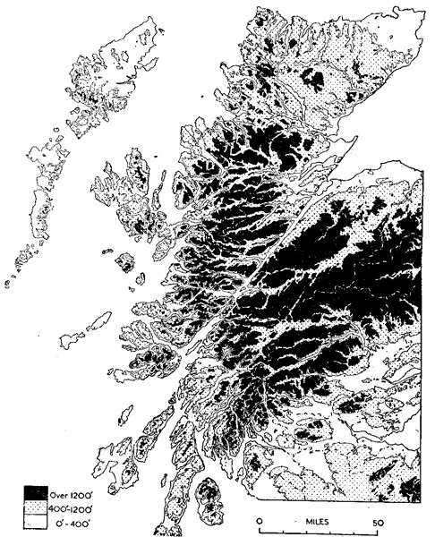
FIG. 4.—Generalized relief features of the Highlands By courtesy of the Land Utilisation Survey of Great Britain
This zone follows the line of the Highland Border Fault from Helensburgh almost to Stonehaven, and then turns at right angles north-westwards to include the middle Dee. The Lochnagar massif, 3,786 feet, may properly belong to the Central Highland zone, but it is a good pivotal point and its long southern slopes all drain into the eastern plain below the Highland Border Fault. From Lochnagar we can cross to Pitlochry and thence to Loch Tay and south-westwards to the head of Loch Lomond and to the sea at the head of Loch Fyne.
The land to the south and east of this zone is highly productive agricultural ground which shows some of the best farming in Scotland.
The zone itself is largely occupied by sheep farms which graze the Blackface breed, but the farther north-eastwards we go from Cowal to the Glens of Angus the better are the sheep, and the same hills on which they graze become easier and better grouse moors. That part of the zone east of the Tay Valley has a very high value as grouse moors for they are among the best in the kingdom. There are also deer forests in the area—west of Loch Lomond where cattle and sheep are also grazed, the Forest of Glenartney, south of Loch Earn and east of Loch Lubnaig, and Invermark Forest south of Lochnagar and in the upper reaches of the Glens of Angus.
The changing nature of this zone within historical time may be gathered from such names on the maps as Forest of Alyth and Forest of Clunie. There would be a large number of trees there hundreds of years ago, but the word forest would be given in the particular connotation of a large uncultivated tract, a usage of the word with which we are more familiar in the Highlands where a deer forest may be practically treeless. The Forests of Clunie and Alyth are now places of rearing farms for cattle and sheep, though, of course, there are still large areas of grouse moor. The golden eagle has gone from here, no longer tolerated by grouse-shooters and the farmers, and the country is not rough enough to give it sanctuary. But in Invermark Forest at the head of the Angus Glens the eagle is given protection. One might say that the red deer have gone from the forests of Clunie and Alyth, and so they have as full residents. This, however, is a frontier zone by our definition, and in winter and hard weather the stags come down the long glens of Glen Isla, Glen Fernait and Atholl. It is in this zone that there is so much outcry against the deer, which become such predatory bands on young corn crops, fields of turnips and potato clamps. A fair amount of coniferous timber is grown in this northeastern area of the frontier zone because the climate is fairly dry and the drainage good.
Dunkeld is one of the gateways to the Highlands proper, at the foot of Strathtay. From Dunkeld to Pitlochry we are in a valley made famous by an earlier Duke of Atholl in his zeal for planting. Larch became one of our most important conifers after the Duke had planted it so extensively during the 18th century. It is interesting to note, also, that it is in this afforested country that the new hybrid between the European and Japanese larch has occurred by a fortunate accident. The hybrid, with its hardiness and immunities, is expected to be a notable forester’s tree in the future. All this area and that already described carries a big stock of roe deer. Despite its unpopularity with the forester, the roe happily persists, apparently as strong as ever.
West of Dunkeld we are into Strath Bran, still timber country, grouse moors and rearing farms. The fauna of Highland hills are constantly pressing down into this zone and are as surely being scotched before the plain of Strathmore is reached. Peregrine falcons, wild cats, eagles, foxes, red deer—all these come through and rarely return. There are no high tops in this area until the head of Glen Almond where the summit of Ben Chonzie, 3,048 feet, dominates everything else in the district; yet there is big country here which the relative smoothness of the hill faces tends to emphasize. The streams have good brown trout and the valleys are always well wooded among the numerous farms. The bird population is rich and varied.
West again, we come into the Forest of Glenartney with its two sharp peaks of Ben Vorlich, 3,224 feet, and Stuc a’ Chroin, 3,189 feet, which are visible from Arthur’s Seat, Edinburgh. Glenartney is the most southerly of the deer forests proper, and though the high country of the two peaks is very suitable for deer, the winter trek of the animals makes the forest harder and harder to maintain in an age when the voice of agriculture is clamant.
The country now is getting much wilder and the easily walked slopes of good heather are giving way to some bare rock faces, to wetter sedgy hills and birch woods rather than conifers. Such is the country either side of Loch Lubnaig where the Forestry Commission is changing the face of the hillsides. The varied scheme of plantings here can serve as a model to confound those who hold that forestry spoils scenery. The same kind of country exists in the Trossachs round Loch Katrine of tourist fame. A Highlander hesitates to call the Trossachs Highland but there is no doubt of the beauty of the scenery. Birch and oak woods line the shore of the loch and hold a good number of black grouse still.
We now come to Loch Lomond, beginning at the foot of Glen Falloch as a narrow and quite uninteresting loch. It becomes more impressive the farther south we go down its twenty-odd miles. The shores are fringed with birches and oaks, and on the west bank particularly there are some fine groups of deciduous trees. Spring and autumn in this region have a charm beyond that of many Highland areas—and autumn, be it known, is a time when Scotland is at her most magnificent. If Ben Lomond looks splendid seen across the loch from Tarbet or Luss, a still finer view can be obtained from the other side where there is no road except the transverse one from Loch Katrine to Inversnaid Lodge, which can be reached also from Aberfoyle. The view westwards from above Inversnaid includes a group of “Munros”1 draining to Loch Sloy—Ben Vorlich (another of the name) with its two peaks, and Ben Vane and Ben Ime. This is the scene of a hydro-electric project and a road is to be made into the area which will certainly allow more people to see the fine scenery than have been able heretofore. This group of hills is in the West of Scotland fair and square and has a high rainfall. The most southerly of the group is Ben Arthur (the Cobbler), 2,891 feet, where there is much bare rock and excellent climbing. At the foot of the sedgy slopes of this hill we are on the west coast at the head of Loch Long. The role of frontier zone is practically lost here, for there is not the rich agricultural land immediately to the south. There is water, and, as the foot of Loch Lomond is reached, the industrial area which is but an extension of Glasgow.
Glasgow is fortunate in its landowners to the north. On both sides of Loch Lomond fair access is given to all, and every attempt is made to preserve the natural woodland and the forest fauna. The Loch Lomond-Trossachs area has priority as a projected national park area. The area would link up with the National Forest Park already established by the Forestry Commission west of Arrochar, and which now includes the privately-given peninsula between Loch Goil and Loch Long. This extremely broken stretch of Highland country, ironically called Argyll’s Bowling Green, is within a few miles of the busy industrial Clyde. The establishment of a national park, and the faithful implementation of the Town and Country Planning Act which is now in force in Scotland, should ensure to Glasgow an area of pristine beauty with a rich natural history, much of which yet awaits patient investigation.
THE CENTRAL HIGHLAND ZONE
This area gives the nearest approach to continental and alpine conditions that we have in Scotland. The southern boundary may be made a line drawn from Lochnagar to the head of Loch Lomond, including the high hills on the north side of Loch Tay. The western boundary would be a line from Loch Lomond through Ben Nevis to Carn Eige and Mam Soul, thence almost due east across the Great Glen at a point just south of Urquhart Castle. This northern line would continue from that point to Tomintoul, one of the highest inhabited villages in Scotland, at 1,280 feet; and the line from Tomintoul to Lochnagar could well form the short eastern boundary. The south-western and north-western corners of this arbitrarily delimited zone are the least typical, in that they lose the plateau-like quality of the Central Highlands proper, but on reflection I should not like to include the peaks round the head of Glen Lyon in the West Highland zone, nor do I think the triangle of country north of the Great Glen may rightly be said to have the sub-arctic-heath complex of vegetation like that of the Northern Highlands. Between 80 and 90 per cent of the ground in this central zone is above the 1,000-foot contour. Arable farming is scarcely practised except in the narrow straths. The farms of Glen Moriston constitute one of the incongruities of the north-western corner of our area, much more so than those of Cromdale and Boat of Garten on the northern edge east of the Spey, for these latter are typical upland farms. The slopes of the hills are mainly of good heather and after 2,500 feet become alpine desert.
The Central Highland zone has its particular interest for naturalists who may be specialists in some branches. There is the botanical field of the high tops, among which Ben Lawers, 3,984 feet, has always held a special place. The schistose of which this hill is composed breaks down easily, and there are exposures of other rocks as well, providing soil which allows a greater variety of alpine plants to grow than on some other summits. The richness of Ben Lawers is also due, probably, to the likelihood of the summit escaping the last glaciation.
The Cairngorm region is of special interest to ornithologists wishing to study the snow bunting and dotterel. The ptarmigan (Plate XVIIb) is common there and the golden eagle (Plate XIIIa) enjoys practical sanctuary, for even sheep-farming is absent from much of the area. The Cairngorm tops are our most considerable arctic relic. The ancient pine forests at the eastern and north-western foot of the Cairngorms are also a relic of a past age and contain the Scottish crested tit (Plate XV) and the Scottish crossbill. The entomologist also finds these forests of special interest. The central Highland area contains some of the biggest deer forests in Scotland, such as Blackmount in Breadalbane of over 80,000 acres (Pl. XV, p. 108), the Forest of Mar, which is almost as large, and the wonderful deer country between Loch Ericht and Loch Laggan, which includes Ben Alder, 3,757 feet.
Our central zone holds the upper reaches of three large river systems—the Dee which flows eastwards from the Cairngorms and the Grampians; the Spey which rises from tiny Loch Spey in the Corrieyairick Forest north of the high top of Creag Meagaidh above Loch Laggan; and the Rivers Garry, Tummel and Tay flowing southwards, joining and continuing as the Tay outside the central alpine zone. The much shorter River Spean which flows westward from Loch Laggan has now disappeared because of the erection of a hydro-electric dam and aqueducts at the foot of Loch Laggan. The Spey, rising at 1,142 feet on the backbone of Scotland, runs 120 miles in a north-easterly direction to the sea in the Moray Firth. It gathers its waters from the Monaliadh hills, from the Grampians and the Cairngorms, the largest area of long-snow-lying country in the Highlands. The River Truim, the Spey’s first large tributary, runs through Badenoch, one of the barest parts of the Highlands. It rises near the Pass of Drumochter, 1,500 feet, which takes the main road from Perth to Inverness. Badenoch has the appearance of a devastated countryside; an appearance partly due to nature and partly to the destructive hand of man several hundred years ago. This area was fought over many a time and bands of broken men were burnt out of their retreats just as the last wolves were a century or two later. The rock is a dull grey and apt to break down into a shaley scree. To my mind, the Forests of Drumochter and Gaick, a little to the east, are the most depressing part of the Highlands. The hills are big humps without individuality, there are screes but not fine cliff faces, and trees are few and far between. Even the weather has a habit of being leaden. The practice of burning heather is always obvious in that no hill face seems to bear an unbroken dark green surface of untouched heather.
West of the road, in the upper Spey Valley region and south of Loch Laggan, the hills become sharper and more shapely and there is a good deal of natural birch, among which are many stands of coniferous timber which in no way spoil the landscape. The Spey and the Truim join above Newtonmore, and from there until the Spey leaves the central zone, the straths and the slopes to over 1,250 feet hold large stands of planted coniferous timbers. There is still plenty of natural birch and juniper scrub as far as Aviemore and beyond. We are in a very beautiful area which is one of the most popular holiday resorts in Scotland for those who like quiet, a mixture of woodland and high hill and a sharp healthy climate of low summer rainfall. At Aviemore the Valley of the Spey widens, and if the observer climbs the wooded hillock of Craigellachie south-west of the village, he will see the old Scots pine forests of Rothiemurchus (Plate 16) and Glenmore as the floor of a great basin formed by the Cairngorms and the little range of hills to the north which culminates in Meall a’ Bhuachaille, 2,654 feet. Loch Morlich (Plate 2) lies in the middle of the basin and its bright sandy shores at the eastern end are visible. The dark green of the timber stretches through the pass or bealach at the foot of Meall a’ Bhuachaille into the Forest of Abernethy (Plate 17). The old trees have suffered more heavily here and have been replaced by plantations of Scots pine, but Abernethy is still beautiful and the birch and juniper take away the grim formality of the solid stands of planted timber.
The Cairngorms, which form the heart and the most extreme alpine conditions of our central zone, are fairly easily reached from Aviemore by means of the track and the pass known as the Lairig Ghru. The Lairig splits the granite massif of the Cairngorms into two halves at a height of 2,750 feet, and is the most spectacular part of the Cairngorms seen from Aviemore or farther west of the Spey. Ben Macdhui, 4,296 feet (Plate 20), is on the east side and Braeriach and Cairntoul on the west side of the pass. The summit of the Lairig is also the county boundary between Inverness-shire and Aberdeenshire. Just south of the summit are the very small lochans known as the Pools of Dee. The water is extremely clear and probably originates from springs. This is the source of the Dee which in twelve miles becomes a considerable river at the Chest of Dee. By time the Linn of Dee is reached (the uppermost limit of salmon in the river) we are into forest again, mostly planted Scots pine until we get below Braemar, where Ballochbuie still holds a fine show of the old pines. These are part of the Royal property at Balmoral.
The Grampian Hills south of the Cairngorms give a sense of vastness. Ben Iurtharn, 3,424 feet; Glas Thulachan, 3,445 feet; and the tops of Beinn a’ Ghlo, 3,671 feet; all these and many another 3,000-footer can be easily climbed on a pony, and once on those clean, smooth summits the pony can be let out to a gallop, so different are they from the sharp peaks, the broken ground and the boggy approaches to the high hills of the West. This country is remote from everywhere and since, once there, it is difficult to get lower than 1,500 feet, there is a great exhilaration in movement through these hills. The snow lies long up here but in summer there is a wealth of excellent grazing for deer, sheep and cattle. I have found patches of beautiful brown soil as high as 1,800 feet. One of the best routes into the Cairngorms is up Glen Tilt from Blair Atholl, past the Falls of Tarf. It is a long and arduous defile or U-shaped glacial valley for most of the way until the Bynack Shieling is reached at 1,500 feet. After that there is the sense of height and space, and the high hills of the Cairngorms lie ahead in a much more picturesque group than when seen from the west. This time it is the noble Glen Dee which splits the massif rather than the sharp nick of the Lairig Ghru. Trees are few up here, though the narrow dens which cut down to the Tarf from Fealar and round about have plenty of small birches, and curiously enough there are a few well-grown spruces at the Bynack Shieling; out of which spruces one day I frightened a capercaillie (Plate XIc). He must have come out of the wooded area of the Dee below Derry Lodge, where this bird is relatively common. The Forest of Mar was one of the places where the caper was reintroduced (unsuccessfully) in the early 19th century.
THE NORTHERN HIGHLANDS, A ZONE OF SUB-ARCTIC AFFINITIES
The northern end of Drum Albyn and its coasts becomes definitely a harder country north of Loch Carron than the West Highland Atlantic zone. The large island of Skye, set athwart the Minch, has an undoubted effect of checking the flow of warm water of the North Atlantic Drift. The coasts of the North-West have several long sea lochs, but the coast as a whole is tighter-knit than the islands and coasts of the Atlantic zone which fans out from the Firth of Lorne into the Atlantic Ocean.
The rocks of the northern zone on the western side are mostly very hard, and poor in such minerals as make good soil; they are Lewisian gneiss, Torridonian sandstone and quartzite; these three have little either of calcium or of fine particles which will become clay and contribute to the soil picture. Furthermore, where the bed rock itself is not showing through (and often it is over 50 per cent of the landscape) the ground is covered with peat which has no bottom of shell sand or clay which, on disintegration or removal of the peat, might become productive soil. Sand dunes occur on the coast at only a few places such as Gairloch, Gruinard Bay, Achnahaird on the north coast of the Coigach peninsula, across Rhu Stoer and at Achmelvich, and at Sandwood Bay a few miles south of Cape Wrath. None of these are of shell sand.
It is a hard, rocky coast to which a multitude of short, rapid rivers run from Drum Albyn—the Laxford from Loch Stack and Loch Mor into Loch Laxford; the Inver from Loch Assynt into Enard Bay; the Kirkaig out of the lochs below Suilven; the Polly, the Kannaird, the Broom and the Dundonnell Rivers; the superb Gruinard River which is only six miles long on its run from Loch na Sheallag; the Little Gruinard, even shorter, coming from the Fionn Loch which is one of the most famous trout lochs in the North; and the River Ewe, only two miles long after it leaves Loch Maree, but very broad; the Kerry River running into Gairloch, famed for its pearls; and the Applecross River which drains much of the peninsula of that name. Most of these rivers are noted for salmon and sea trout, though some are curiously poor. As things stand at the moment the rivers of this region, so variable in their flow from day to day, make up in economic value for the poverty of the land for agricultural and pastoral purposes and for general lack of timber.
The boreal or sub-arctic affinities of the northern zone are most marked on the two geological formations already named, the gneiss and the sandstone. Each rock has its very distinctive form and each contributes to what is probably the wildest scenery in Scotland except for the small area of the Cuillin Hills of Skye (Plate IIIa). But here in the interplay of gneiss, sandstone and quartzite the naturalist may walk for a week or more and see no human habitation other than an occasional stalker’s cottage. So rough and wild is the country that habitations unconnected with sport are difficult to find away from the sea’s edge. The outcrop of limestone in the Assynt district allows the exception of the crofting townships of Elphin and Cnockan to which allusion was made in the first chapter.
The Lewisian gneiss of the mainland rises to greater heights in the general run of the country than it does in the Hebrides, except in Harris and at one place in South Uist. Also, it is not hidden under such a blanket of peat as in Lewis. The gneiss country of Sutherland and Ross is one of a myriad little hills of great steepness, with little glens running hither and thither among them. The lochans are seemingly countless and most of them have a floor of peat. The gneiss hills themselves are like rock buns, looking as if they had risen in some giant oven and set into their rough shapes. This ground holds up the water in pockets in the rock and allows the formation of cotton sedge bogs and such very shallow lochans as grow water lobelia and water lilies. When these lochans are near the sea and grow reeds the bird life is rich. Greenshanks (Plate XIIb) are common in the gneiss country—say one pair to 3,000 acres, which is quite twice as many as may be found on the adjoining Torridonian sandstone. Heather (Calluna) is not common on the gneiss; the complex is one of dwarf willow, sedge and poor grasses. Also, this type of vegetation does not appreciably alter in the altitudinal range of the gneiss. For example, I could find no major difference in sample patches in the Gruinard Forest at the foot of Carn nam Buailtean at 600 feet, and at the top of Creag Mheall Mor in the Fisherfield Forest at over 2,000 feet. The hills maintain over all their mottled pattern of green and grey, and when the snow is on the tops there is never the distinctive line at about 1,750 feet which is commonly seen on the Torridonian formation.
The gneiss is difficult country to walk through: by keeping to the little glens it is impossible to steer a straight course for any distance and no one would attempt to go in a straight line over the hills. On the upper gneiss country where many detours are necessary round rock faces and soft spots, a speed of one mile an hour is quite good going. It is also quite easy to lose one’s self, for these little round hills are all very much alike.
The crofting townships on the gneiss are strictly coastal. Their arable grounds (Plate 7b) are usually tiny patches of an acre or less in the hollows or in the less steep faces of the rocks. Loch Laxford, a sea loch, shows some typical low gneiss country with crofts at Foindlemore and Fanagmore.
The gneiss tends to get higher the farther it goes inland. A’ Mhaighdean (the maiden) reaches 2,850 feet above the Dubh Loch in Ross, 10–12 miles from the sea as the crow flies. It forms a high cliff face on this hill of exceptional grandeur, a rare thing for the formation on the mainland. Its sea cliffs are nowhere impressive here because they are never sheer or higher than a couple of hundred feet. Even the Torridonian, a formation which one might expect to make magnificent cliffs, does not provide these in any quantity at the sea’s edge. The island of Handa, near Scourie and opposite Fanagmore at the mouth of Loch Laxford, is a splendid exception. The Torridonian rock is stratified horizontally, so the vertical breaks make nesting ledges for sea birds such as guillemots, razorbills and kittiwakes. There are sheer cliffs of nearly 400 feet on Handa, and in the little screes of earth among these, now covered with fescue and scurvy grass, there are large colonies of puffins and fulmar petrels. The white-tailed sea eagle nested on Handa until the second half of the 19th century. Handa is one of the few places on the Torridonian sandstone which provide true sea-bird cliffs. No other place on the formation can compare with it for numbers of auks, except perhaps Clo Mor, about four miles east of Cape Wrath, where there is a cliff of over 800 feet.