 полная версия
Man on the Ocean: A Book about Boats and Ships
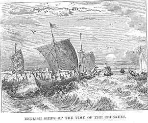
The result of all this was that there was a great moving, and, to some extent, commingling of the nations. The knowledge of arts and manufactures was interchanged, and of necessity the knowledge of various languages spread. The West began constantly to demand the products of the East, wealth began to increase, and the sum of human knowledge to extend.
Shortly after this era of opening commercial prosperity in the Mediterranean, the hardy Northmen performed deeds on the deep which outrival those of the great Columbus himself, and were undertaken many centuries before his day.
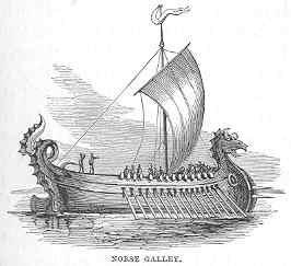
The Angles, the Saxons, and the Northmen inhabited the borders of the Baltic, the shores of the German Ocean, and the coasts of Norway. Like the nations on the shores of the Mediterranean, they too became famous navigators; but, unlike them, war and piracy were their chief objects of pursuit. Commerce was secondary.
In vessels resembling that of which the above is a representation, those nations went forth to plunder the dwellers in more favoured climes, and to establish the Anglo-Saxon dominion in England; and their celebrated King Alfred became the founder of the naval power of Britain, which was destined in future ages to rule the seas.
It was the Northmen who, in huge open boats, pushed off without chart or compass (for neither existed at that time) into the tempestuous northern seas, and, in the year 863, discovered the island of Iceland; in 983, the coast of Greenland; and, a few years later, those parts of the American coast now called Long Island, Rhode Island, Massachusetts, Nova Scotia, and Newfoundland. It is true they did not go forth with the scientific and commercial views of Columbus; neither did they give to the civilised world the benefit of their knowledge of those lands. But although their purpose was simply selfish, we cannot withhold our admiration of the bold, daring spirit displayed by those early navigators, under circumstances of the greatest possible disadvantage—with undecked or half-decked boats, meagre supplies, no scientific knowledge or appliances, and the stars their only guide over the trackless waste of waters.
In the course of time, one or two adventurous travellers pushed into Asia, and men began to ascertain that the world was not the insignificant disc, or cylinder, or ball they had deemed it. Perhaps one of the chief among those adventurous travellers was Marco Polo, a Venetian, who lived in the latter part of the thirteenth century. He made known the central and eastern portions of Asia, Japan, the islands of the Indian Archipelago, part of the continent of Africa, and the island of Madagascar, and is considered the founder of the modern geography of Asia.
The adventures of this wonderful man were truly surprising, and although he undoubtedly exaggerated to some extent in his account of what he had seen, his narrations are for the most part truthful. He and his companions were absent on their voyages and travels twenty-one years.
Marco Polo died; but the knowledge of the East opened up by him, his adventures and his wealth, remained behind to stir up the energies of European nations. Yet there is no saying how long the world would have groped on in this twilight of knowledge, and mariners would have continued to “hug the shore” as in days gone by, had not an event occurred which at once revolutionised the science of navigation, and formed a new era in the history of mankind. This was the invention of the mariner’s compass.
Chapter Five.
The Mariner’s Compass—Portuguese Discoveries
“What is the compass?” every philosophical youth of inquiring disposition will naturally ask. We do not say that all youths will make this inquiry. Many there are who will at once say, “Oh, I know! It’s a needle with a card on the top of it—sometimes a needle with a card under it—which always points to the north, and shows sailors how to steer their ships.”
Very well explained indeed, my self-sufficient friend; but you have not answered the question. You have told us what a compass is like, and one of the uses to which it is applied; but you have not yet told what it is. A man who had never heard of a compass might exclaim, “What! a needle! Is it a darning needle, or a knitting needle, or a drawing-through needle? And which end points to the north—the eye or the point? And if you lay it on the table the wrong end to the north, will it turn round of its own accord?”
You laugh, perhaps, and explain; but it would have been better to have explained correctly at first. Thus:—
The mariner’s compass is a small, flat bar of magnetised steel, which, when balanced on a pivot, turns one of its ends persistently towards the north pole—the other, of course, towards the south pole; and it does this in consequence of its being magnetised. A card is fixed above, sometimes below, this bar of steel (which is called the needle), whereon are marked the cardinal points—north, south, east, and west—with their subdivisions or intermediate points, by means of which the true direction of any point can be ascertained.
“Aha!” you exclaim, “Mr Author, but you yourself have omitted part of the explanation. Why is it that the magnetising of the needle causes it to turn to the north?”
I answer humbly, “I cannot tell;” but, further, I assert confidently, “Neither can anybody else.” The fact is known, and we see its result; but the reason why magnetised steel or iron should have this tendency, this polarity, is one of the mysteries which man has not yet been able to penetrate, and probably never will.
Having explained the nature of the compass, as far as explanation is possible, we present our reader with a picture of one.
It will be seen that there are four large points—N, S, E, and W—the cardinal points above referred to, and that these are subdivided by twelve smaller points, with one little black triangular point between each, and a multitude of smaller points round the outer circle. To give these points their correct names is called “boxing the compass,”—a lesson which all seamen can trip off their tongues like A, B, C, and which most boys could learn in a few hours.

For the sake of those who are anxious to acquire the knowledge, we give the following explanation: Let us begin with north. The large point midway between N and E (to the right) is north-east. The corresponding point midway between N and W (to the left) is north-west. A glance will show that the corresponding points towards the south are respectively south-east and south-west (usually written S.E. and S.W., as the two former points are written N.E. and N.W.). Now, to read off the compass with this amount of knowledge is very simple. Thus: North, north-east, east, south-east, south, south-west, west, north-west, north. But be it observed that, in the language of the sea, the th is thrown overboard, except when the words north and south occur alone. When conjoined with other points they are pronounced thus: nor’-east, sou’-east; and so on.
To come now to the smaller subdivisions, it will suffice to take a quarter of the circle. The point midway between N.E. and N. is “nor’-nor’-east” (N.N.E.), and the corresponding one between N.E. and E. is “east nor’-east” (E.N.E.). These points are again subdivided by little black points which are thus named:– The first, next the N., is “north by east” (N. by E.); the corresponding one next the E. is “east by north” (E. by N.). The second black point from N. is “nor’-east by north” (N.E. by N.), and the corresponding one—namely, the second black point from east—is “nor’-east by east” (N.E. by E.). Thus, in reading off the compass, we say—beginning at north and proceeding to east—North: north by east; nor’-nor’-east; nor’-east by north; nor’-east; nor’-east by east; east nor’-east; east by north; east;—and so on with the other quarters of the circle.
So much for “boxing the compass.” The manner in which it is used on board ship, and the various instruments employed in connection with it in the working of a vessel at sea, will be explained shortly; but first let us glance at the history of the compass.
It is a matter of great uncertainty when, where, and by whom the mariner’s compass was invented. Flavio Gioia, a Neapolitan captain or pilot, who lived about the beginning of the fourteenth century, was generally recognised throughout Europe as the inventor of this useful instrument; but time and research have thrown new light on this subject. Probably the Neapolitan pilot was the first who brought the compass into general notice in Europe; but long before 1303 (the year in which it was said to have been invented) the use of the magnetic needle was known to the Chinese.
Loadstone, that mineral which has the mysterious power of attracting iron, and also of imparting to iron its own attractive power, was known to the Chinese before the year 121, in which year a famous Chinese dictionary was completed, wherein the word magnet is defined as “the name of a stone which gives direction to a needle.” This proves not only that they knew the attractive properties of the loadstone, and its power of imparting these properties to metal, but also that they were aware of the polarity of a magnetised needle. Another Chinese dictionary, published between the third and fourth centuries, speaks of ships being guided in their course to the south by means of the magnet; and in a medical work published in China in 1112, mention is made of the variation of the needle, showing that the Chinese had not only used the needle as a guide at sea, but had observed this one of its well-known peculiarities—namely, the tendency of the needle to point in a very slight degree away from the true north.
In the thirteenth century, too, we find mention made of the needle by a poet and by two other writers; so that whatever Flavio Gioia may have done (and it is probable he did much) in the way of pushing the compass into notice in Europe, he cannot be said to be the inventor of it. That honour doubtless belongs to the Chinese. Be this as it may, the compass was invented; and in the fourteenth century it began that revolution in maritime affairs to which we have alluded.
The first compasses were curiously formed. The Chinese used a magnetised needle, which they placed in a bit of rush or pith, which was floated in a basin of water, and thus allowed to move freely and turn towards the poles. They also made needles in the form of iron fish. An Arabian author of the thirteenth century thus writes:– “I heard it said that the captains in the Indian seas substitute for the needle and reed a hollow iron fish magnetised, so that, when placed in the water, it points to the north with its head and to the south with its tail. The reason that the iron fish does not sink, is that metallic bodies, even the heaviest, float when hollow and when they displace a quantity of water greater than their own weight.”
The use of the compass at sea is so simple, that, after what has been said, it scarcely requires explanation. When a ship sets sail for any port, she knows, first of all, the position of the port from which she sets sail, as well as that to which she is bound. A straight line drawn from the one to the other is her true course, supposing that there is deep, unobstructed water all the way; and if the compass be placed upon that line, the point of the compass through which it passes is the point by which she ought to steer. Suppose that her course ran through the east point of the compass: the ship’s head would at once be turned in that direction, and she would continue her voyage with the needle of the compass pointing straight across the deck, and the east and west points straight along it.
But various causes arise in the actual practice of navigation to prevent a ship keeping her true course. Winds may be contrary, and currents may drive her either to the one side or the other of it; while land—promontories, islands, and shallows—compel her to deviate from the direct line. A vessel also makes what is called “leeway;” which means that, when the wind blows on her side, she not only advances forward, but also slides through the water sidewise. Thus, in the course of a day, she may get a considerable distance off her true course—in sea parlance, “make a good deal of leeway.”
To perform the voyage correctly and safely in the face of these obstacles and hindrances is the aim and end of navigation; and the manner of proceeding is as follows:—
The hour is carefully noted on setting sail, and from that moment, night and day, to the end of the voyage, certain observations are made and entered in the ship’s journal, called the log. Every hour the rate at which the ship is going is ascertained and carefully noted. The point of the compass towards which the ship is to be steered is given by the captain or officer in command to the steersman, who stands at the wheel with a compass always before him in a box called the “binnacle.” The course is never changed except by distinct orders from those in command; and when it is changed, the hour when the change is made and the new course to be steered are carefully noted down. Thus, at the end of the day, or at any other time if desired, the position of the ship can be ascertained by her course being drawn upon a chart of the ocean over which she is sailing,—correct charts, or maps, being provided by the captain before starting.
The estimate thus made is, however, not absolutely correct. It is called the “dead-reckoning,” and is only an approximation to the truth, because allowance has to be made for leeway, which can only be guessed at. Allowance has also to be made for variations in the rate of sailing in each hour, for the winds do not always blow with exactly the same force during any hour of the day. On the contrary, they may vary several times within an hour, both in force and in direction. Those variations have to be watched and allowed for; but such allowance may be erroneous in a greater or less degree. Currents, too, may have exerted an unseen influence on the ship, thus rendering the calculation still less correct. Nevertheless, dead-reckoning is often the only guide the sailor has to depend upon for days at a time, when storms and cloudy skies prevent him from ascertaining his true position by other means, of which we shall speak presently.
Of course, in the early days of navigation there were no charts of the ocean. The navigator knew not whither he was hurrying over the wild waste of waters; but by observing the relative position of some of the fixed stars to his course while sailing out to sea, he could form a rough idea of the proper course to steer in order to return to the port whence he had started.
The compass, then, shows the sailor the course he has been going, and the log (of which more presently) enables him to ascertain the rate at which he has proceeded; while his chronometers, or time-keepers, tell him the time during which the course and rate of sailing have been kept up. And many a long cruise on the unknown deep has been successfully accomplished in days of old by bold seamen, with this method of dead-reckoning; and many a mariner at the present day depends almost entirely on it, while all are, during thick, stormy weather, dependent on it for days and sometimes weeks together.
The log, to which we have referred, is the instrument by which is determined the rate at which a ship is progressing. It is a very simple contrivance: a triangular piece of wood about the size of a large saucer, with a piece of stout cord fastened to each corner, the ends of the cords being tied together, so that when held up, the “log,” as it is called, resembles one of a pair of scales. One of the cords, however, is only temporarily attached to its corner by means of a peg, which when violently pulled comes out. One edge of the triangle is loaded with lead. The whole machine is fastened to the “log-line,”—a stout cord many fathoms long, which is wound on a large reel.
“Heaving the log,” as we have said, takes place every hour. One sailor stands by with a sand-glass which runs exactly half a minute. Another holds the wooden reel; and a third heaves the log overboard, and “pays out” line as fast as he can make the reel spin. The instant it is thrown the first sailor turns the sand-glass. The log, being loaded on one side, floats perpendicularly in the water, remaining stationary of course; while the man who hove it watches sundry knots on the line as they pass over the stern of the ship, each knot representing a mile of rate of speed in the hour. As the last grain of sand drops to the bottom of the glass the first sailor gives a sharp signal, and the second clutches and checks the line, examines the knot nearest his hand, and thus knows at once how many knots or miles the ship is sailing at that time. The sudden stoppage of the line jerks the peg, before referred to, out of the log, thereby allowing the other two fixed cords to drag it flat and unresisting over the surface of the sea, when the line is reeled up and put by. The flight of another hour calls for a repetition of the heaving of the log.
As scientific knowledge advanced, instruments of peculiar and more complicated form were devised to enable navigators to ascertain more correctly their position on the surface of the sea; but they did not, and never will, supersede the method by dead-reckoning—for this reason, that the latter can be practised at all times, while the former are useless unless the sun, moon, or stars be visible, which in some latitudes they are not for many days and weeks, when clouds and fogs shroud the bright sky from view.
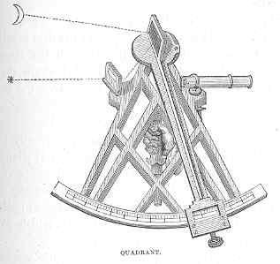
The Quadrant is the chief of those instruments. It is represented on next page. To give a succinct account of this would take up more space than we can spare. It may suffice the general reader to say that by observing the exact position of the sun at noon, or of the moon or a star, in relation to the horizon, the precise latitude of a ship—that is, her distance north or south of the equator—is ascertained. The method of “taking an observation” is complicated, and difficult to explain and understand. We refer those who are curious on the point to treatises on navigation.
Chronometers are exceedingly delicate and perfect time-keepers, or watches, which are very carefully set at the commencement of a voyage. Thus the time at the meridian whence a vessel starts is kept up during the voyage. By means of an observation of the sun with the quadrant, or sextant (a somewhat similar instrument), the true time at any particular point in the voyage may be ascertained. A difference is found to exist between the time at the spot where the observation is taken, and the time of the chronometer. A calculation founded on this difference gives the ship’s longitude—that is, her distance east or west of the meridian that passes through Greenwich. That meridian is an imaginary line drawn round the world longitudinally, and passing through the north and south poles, as the equator is a line passing round it latitudinally.
When a ship’s latitude and longitude have been ascertained, and a line drawn through the first parallel to the equator, and another line through the second parallel to the first meridian, the point where these two lines intersect is the exact position of the ship upon the sea.
The size and form of ships having gradually improved, the compass and other scientific appliances having been discovered, cannon also and gunpowder having been invented, seamen became more courageous and venturesome; and at last the Portuguese nation began that career of maritime enterprise which won for it the admiration of the world.
About the beginning of the fourteenth century (1330), the Canary Islands, lying off the west coast of Africa, were re-discovered by the accident of a French ship being blown off the coast in a storm, and finding shelter amongst them. This group had been known to the ancients under the name of the Fortunate Islands, but had been forgotten for more than a thousand years. During the course of the century the Spaniards plucked up courage to make discoveries and settlements upon them, although by so doing they were compelled to undergo that much-dreaded ordeal—sailing out of sight of their once fondly “hugged” land!
In the beginning of the next century arose a prince, Don Henry, son of John the First of Portugal, whose anxiety to promote discovery, and to find a passage by sea round the coast of Africa to India, induced him to send out many expeditions, all of which accomplished something, and many of which added very extensively to the geographical knowledge of the world at that time. Navigators, sent out by him from time to time, discovered the Madeira Islands; sailed along the western coast of Africa a considerable distance; ascertained the presence of gold-dust among the savages on the Gulf of Guinea; discovered the Azores, besides numerous other islands and lands; crossed the equator, and approached to within about eighteen hundred miles of the south-most cape of Africa.
The discovery of gold-dust stirred up the energies of the Portuguese in a remarkable degree, and caused them cheerfully to undertake ventures which, without that inducement, they would probably never have undertaken at all. Moreover, they had now learned to quail less at the idea of losing sight of land; and towards the end of the fifteenth century (1486), Bartholomew Diaz, an officer of the household of John the Second, achieved the grand object which had long been ardently desired by the Portuguese—he doubled the great southern cape of Africa, which King John named the “Cape of Good Hope,” although Diaz had named it the “Cape of Tempests.” The circumstance is thus alluded to by a poet of that period—
“At Lisboa’s court they told their dread escape,And from her raging tempests named the Cape.‘Thou southmost point,’ the joyful king exclaimed,‘Cape of Good Hope be thou for ever named!’”Chapter Six.
Boats, Model-Boat Making, etcetera
Leaving the subject of ancient ships and navigation, we shall now turn our attention to the more recent doings of man on the ocean, and, before entering into the details of ships and ship-building, devote a little time and space to the consideration of boats.
There are great varieties of boats—as regards shape, size, material, and use—so that it is not easy to decide on which we shall first fix our attention. There are large and small, long and short boats; flat, round, sharp, and bluff ones,—some clumsy, others elegant. Certain boats are built for carrying cargo, others for purposes of war. Some are meant for sailing, some for rowing; and while many kinds are devoted to business, others are intended solely for pleasure. Before we refer to any of these, perhaps our young readers will not object to be told how to construct:—
A Model BoatWe need scarcely say that it is not expedient for a boy to attempt to build a model boat in the same manner as a regular boat-builder constructs one for actual service. It would be undertaking an unnecessary amount of labour to lay a keel and form ribs and nail on planks in the orthodox fashion, because, for all practical purposes, a boat cut out of a solid block of wood is quite as useful, and much more easily made.
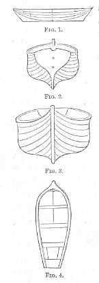
The first thing you have to do, my young boat-builder, then, is to go and visit a harbour or beach where varieties of boats are to be found, and, having settled in your mind which of them you intend to copy, make a careful drawing, in outline, of its form in four different positions. First, a side view, as in Figure 1. Then the stern, with the swelling sides of the boat visible, as in Figure 2. The bow, as in Figure 3; and a bird’s-eye view, as in Figure 4. The last drawing can be made by mounting on some neighbouring eminence, such as a bank or a larger boat, or, if that is impossible, by getting upon the stern of the boat itself, and thus looking down on it. These four drawings will be of great service in enabling you to shape your model correctly; for as you proceed with the carving you can, by holding the model up in the same position with any of the drawings, ascertain whether you are progressing properly; and if you get the correct form of your boat in these four positions, you will be almost certain to make a good boat. If, on the other hand, you go to work without drawings, the probability is that your boat will be lopsided, which will prevent it from floating evenly; or crooked, which will tend to check its speed in sailing, besides being clumsy and not “ship-shape,” as the sailors have it.


